By Duane and Tracy Marsteller, February 6, 2022
Town of New Hope Marker side
| Near Main Drive/New Hope Highway, 0.2 miles south of Johnson Avenue, on the right when traveling south. |
| On Ikard Road, 0.3 miles north of Nebo Road, in the median. |
| On Beth Road just west of New Market Road (County Road 100), on the right when traveling east. |
| On Winchester Road south of Old Mountain Fork Road, on the right when traveling south. |
| On Hidden Lake Drive SE at Old Big Cove Road, on the right when traveling west on Hidden Lake Drive SE. |
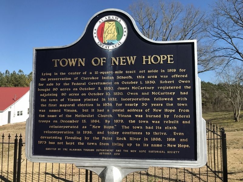
| Near County Route 63, 0.2 miles south of County Route 53, on the right when traveling south. |
| Near County Road 54 at County Route 59, on the right when traveling west. |
| On County Road 54 at County Route 59, on the right when traveling west on County Road 54. |
| On Alabama Route 28, 0.1 miles west of Jefferson Road (County Road 57), on the right when traveling west. |
| On County Road 63 at Bee Lane, on the left when traveling north on County Road 63. |
| On Bee Lane (County Road 38) 0.1 miles east of County Road 63, on the right when traveling east. |
| On Shiloh Church Road (County Road 82) 0.6 miles north of County Road 55, on the left when traveling north. |
| Near Highway 172/241, 0.1 miles north of Elliot Drive. |
| On U.S. 278 at milepost 66,, 0.2 miles north of Road 2, on the right when traveling north. |
| Near West Main Street (Alabama Route 205) at Lombardy Street, on the right when traveling west. |
| On West Main Street (Alabama Route 205), on the right when traveling west. |
| On Shoal Creek Trail NE, 0.1 miles east of North Main Street (Alabama Highway 69), on the left when traveling east. |
| Near Brashiers Chapel Road, 0.1 miles east of Cobb Road, on the left when traveling east. |
| On Fry Gap Road (County Route 48) 0.1 miles west of Rock Hill Road, on the right when traveling east. |
| On Shoal Creek Road at Brentwood Lane, on the right when traveling east on Shoal Creek Road. |
| On Old Bethel Road, 0.2 miles north of County Route 111, on the left when traveling north. |
| On Browns Valley Road at Robert Circle, on the right when traveling north on Browns Valley Road. |
| On Florida Short Route/Gunter Avenue (U.S. 431) at Lurleen B Wallace Drive, on the right when traveling south on Florida Short Route/Gunter Avenue. |
| On Iberville Drive north of Cadillac Avenue, on the left when traveling north. |
| Near Virginia Street just east of Murphy Street. |
| On Dr Martin Luther King Jr Avenue at Cassidy Street, on the right when traveling north on Dr Martin Luther King Jr Avenue. |
| Near Gayle Street at Montgomery Street, on the right when traveling south. |
| Near Virginia Street, 0.1 miles east of South Ann Street. |
| Near Virginia Street at Owens Street, on the right when traveling west. |
| On South Ann Street, 0.1 miles north of Virginia Street, on the right when traveling north. |
| Near Virginia Street, 0.1 miles east of South Ann Street. |
| On Holt Road (Local Route 1800), on the right when traveling north. |
| On Government Street (U.S. 90) at South Scott Street, on the right when traveling east on Government Street. |
| On Bay Bridge Cutoff Road, 0.1 miles north of Chin Street, on the left when traveling south. |
| On Dauphin Street west of South Claiborne Street, on the right when traveling east. |
| On Virginia Street, on the right when traveling west. |
| Near Old Shell Road (County Road 70) east of Cosgrove Drive, on the right when traveling east. |
| Near Fincher Road east of Stadium Road. |
| On Moffett Road (U.S. 98) at Sun Valley Drive, on the right when traveling west on Moffett Road. |
| On Wulff Road, 0.2 miles south of Moffett Road (U.S. 98), on the left when traveling south. |
| On Perryville Road south of County Road 30, on the left when traveling south. |
| On Wright Street (County Road 38) 2.6 miles west of South Butler Springs Road (County Road 7), on the right when traveling west. |
| Near Folmar Parkway south of Bill Joseph Parkway, on the right when traveling south. |
| On U.S. 331, on the right when traveling south. |
| On Old Pike Road, 0.1 miles north of Cedar Pines Road, on the right when traveling north. |
| On Wares Ferry Road (County Route 64) 0.4 miles east of Dozier Road, on the left when traveling east. |
| On Lincoln Road, 0.1 miles north of Harrison Road, on the right when traveling north. |
| Near Upper Wetumpka Road at North Ripley Street, on the left when traveling east. Reported missing. |
| Near Upper Wetumpka Road. |
| On Coosa Street at Tallapoosa Street, on the right when traveling north on Coosa Street. |
| Near Stella Street at Clarmont Avenue, on the right when traveling north. |
| On Lincoln Road, 0.1 miles north of Harrison Road, on the right when traveling north. |
| On Lincoln Road, 0.1 miles north of Harrison Road, on the right when traveling north. |
| Near Upper Wetumpka Road. |
| Near Greenwood Cemetery Road, 0.5 miles east of Lincoln Road. |
| On Cong W L Dickinson Drive (County Road 21) north of Gunter Park Drive, on the right when traveling north. |
| On Gunter Park Drive at Cong W L Dickinson Drive (County Road 21), on the right when traveling west on Gunter Park Drive. |
| Near Columbus Street east of North Ripley Street, on the right when traveling west. |
| Near Upper Wetumpka Road west of Vonora Avenue, on the right when traveling east. |
| On Avenue of the Waters, 0.1 miles east of Marler Road (County Route 37), on the right when traveling west. |
| Near Briar Lane, 0.1 miles west of Ryan Road, on the right when traveling west. |
| On Mobile Highway (U.S. 31) at Windham Road, on the right when traveling north on Mobile Highway. |
| On Naftel Ramer Road (County Road 61) at Smiley Ferry Road, on the right when traveling north on Naftel Ramer Road. |
| On Evergreen Road at County Road 55, on the right when traveling south on Evergreen Road. |
| Near Clements Street, 0.1 miles east of Washington Street, on the left when traveling east. |
| Near Clements Street, 0.1 miles east of Washington Street, on the left when traveling east. |
| On Columbus Road (State Highway 14) at Old Garden Road, on the right when traveling north on Columbus Road. |
| On Alabama Route 17, 0.2 miles south of Iron Bridge Road, on the right when traveling south. |
| Near Lower Vienna Road west of State Highway 14, on the right when traveling west. |
| On Tennille Road (County Route 4421) at County Route 4418, on the right when traveling south on Tennille Road. |
| On Salem Road, 0.1 miles west of County Road 7702, on the right when traveling west. |
| On County Road 2290, 0.8 miles north of Little Oak Road (County Road 2238), on the right when traveling north. |
| On County Road 6600 at County Road 6602, on the right when traveling north on County Road 6600. |
| Near U.S. 165. Reported damaged. |
| On Sandfort Road (County Road 22) at Dusty Road, on the right when traveling west on Sandfort Road. |
| Near Montevallo Road (State Highway 119) 0.2 miles south of Woodbrook Trail. |
| On County Road 24, on the right when traveling south. |
| On Mellow Drive north of U.S. 31, on the right when traveling north. |
| On County Road 47 at Whisenhunt Road, on the right when traveling north on County Road 47. |
| On Alabama Route 25, on the left when traveling south. |
| On Helena Road (County Road 261) at Cemetery Circle, on the right when traveling north on Helena Road. |
| On Co Rd 17, 0.1 miles north of Cedar Grove Parkway, on the right when traveling north. |
| On County Road 17 north of Longmeadow Road, on the right when traveling north. |
| On County Route 42, 1 mile south of Alabama Highway 25, on the left when traveling south. |
| On Alabama Route 25 at County Route 469, on the left when traveling south on State Route 25. |
| On County Route 280, on the left when traveling north. |
| On McGowin Road, on the left when traveling north on McGowin Road. |
| On Liberty Road at U.S. 411, on the right when traveling west on Liberty Road. |
| On Holly Hill Road (County Route 7), on the right when traveling south. |
| On West 4th Street at Woodlawn Avenue, on the right when traveling west on West 4th Street. |
| On East Ft. Williams Street east of North Broadway Avenue (Alabama Route 21), on the left when traveling east. |
| Near East Ft. Williams Street east of North Broadway Avenue (Alabama Route 21), on the left when traveling east. |
| On Horseshoe Bend Road (Alabama Route 49) at Church Road, on the right when traveling south on Horseshoe Bend Road. |
| Near Battlefield Park Tour Road. |
| Near U.S. 82, 0.8 miles east of Roberts Road when traveling east. |
| On Bear Creek Road, 0.1 miles west of Argonne Forest Drive, on the right when traveling west. |
| On Kirkbride Lane at Harper Court, on the right when traveling west on Kirkbride Lane. |
10986 entries matched your criteria. Entries 201 through 300 are listed above.
⊲ Previous 100 —
Next 100 ⊳