By William Fischer, Jr., March 12, 2010
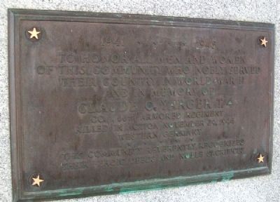
Beaverdam & Vicinity World War II Memorial (Rear)
| On West Street/Napoleon Road at Lincoln Highway (Ohio Route 696), on the left when traveling north on West Street/Napoleon Road. |
| On Lake Street at County Line Road, on the right when traveling east on Lake Street. |
| On East Jefferson Street (Ohio Route 103) west of Huber Street, on the right when traveling east. |
| On Lincoln Highway (Ohio Route 66) at North Main Street (Ohio Route 66), on the right when traveling east on Lincoln Highway. |
| On East Main Street at Roger Street, on the right when traveling east on East Main Street. |
| On East 2nd Street east of N Main Street, on the left when traveling east. |
| On North McClure Road, 1 mile south of Ohio Route 81, on the left when traveling south. |
| On Elm Street, on the left when traveling east. |
| On Reservoir Road, 0.3 miles east of Metzger Road, on the right when traveling east. |
| On Central Avenue, in the median. |
| On Rockport Road just east of Port Street, on the right when traveling east. |
| On North Main Street (Ohio Route 117) near West 6th Street, on the right when traveling north. |
| On West Main Street (Route 39) west of North Market Street, on the right when traveling west. |
| On U.S. 224 at Ohio Route 58, on the right when traveling east on U.S. 224. |
| On Walnut Boulevard east of Hulbert Avenue, in the median. |
| Near Main Avenue south of West 44th Street, on the left when traveling north. |
| On Main Avenue at West 44th Street, on the left when traveling north on Main Avenue. |
| On Main Avenue north of West 44th Street, on the left when traveling north. |
| On Ohio Route 193 south of Grand Army of the Republic Highway (U.S. 6), on the right when traveling south. |
| On Grand Army of the Republic Boulevard (U.S. 6) at Ohio Route 534, in the median on Grand Army of the Republic Boulevard. |
| On East Jefferson Street at South Chestnut Street (Ohio Route 46/307), on the right when traveling east on East Jefferson Street. |
| On U.S. 322, 0.1 miles west of Ohio Route 193, on the left when traveling west. |
| On Richland Avenue at Plains Road (Ohio Route 682), on the left when traveling south on Richland Avenue. |
| On South Green Drive, 0.1 miles east of Richland Avenue (U.S. 50), on the right when traveling east. |
| On High Street (Ohio Route 13), on the right when traveling south. |
| On East Main Street, on the right when traveling east. |
| Near Lock 2 Road, on the right when traveling east. |
| Near Lock 2 Road (County Road 70) east of Quelhorst Road, on the right when traveling east. |
| On New Bremen New Knoxville Road (County Road 65A) north of Kettler Road (County Road 74), on the right when traveling south. |
| On Arch Street at Main Street (Ohio Route 147), on the right when traveling north on Arch Street. |
| On Fair Street, on the right when traveling west. |
| On Guernsey Street north of 34th Street, on the right when traveling north. |
| On Guernsey Street at 34th Street, on the right when traveling north on Guernsey Street. |
| On Zane Highway just north of Grant Avenue, on the right when traveling north. |
| Near Allen Avenue at Philip Street. |
| On Walnut Avenue, in the median. |
| On West Main Street (U.S. 40) at North Market Street, on the right when traveling west on West Main Street. |
| Near Anderson State Road (County Route 48), on the left when traveling east. |
| On Anderson State Road (U.S. 50), on the right when traveling south. |
| On South Main Street, on the right when traveling north. |
| Near North High Street (U.S. 68). |
| On High Street (Ohio Route 129/177) at Monument Street, on the right when traveling west on High Street. |
| On Clark Street at Manchester Avenue, on the right when traveling north on Clark Street. |
| On Oxford Street at Hamilton-Richmond Road, on the left when traveling north on Oxford Street. |
| On Tylersville Road, 0.9 miles east of I-75 Exit 22, on the left when traveling east. |
| On Cemetery Drive Southeast, 0.1 miles south of 4th Street Southeast, in the median. |
| On Alliance Road Northwest (Ohio Route 183) 0.5 miles south of Bridge Street, on the right when traveling east. |
| On East Street (Ohio Route 559) at Cherry Street, on the right when traveling north on East Street. |
| On Jefferson Street at Plum Street, on the right when traveling north on Jefferson Street. |
| On North Main Street (U.S. 68) at West Court Street, on the right when traveling south on North Main Street. |
| On U.S. 68 at Pearce Place, on the right when traveling south on U.S. 68. |
| On Scioto Street (U.S. 36) at Ames Avenue, on the right when traveling east on Scioto Street. |
| On Main Street (U.S. 68), on the right when traveling south. |
| Near Urbana Woodstock Pike (County Route 2), on the right when traveling west. |
| On McConkey Road (County Route 369), on the left when traveling south. |
| On Mount Moriah Drive, in the median. |
| On Ohio Route 28 west of Goshen Road, on the left when traveling west. |
| On Goshen- Belfast Road (County Route 57), on the right when traveling south. |
| On Broadway Street at 2nd Street, on the right when traveling west on Broadway Street. |
| On Ohio River Scenic Byway (U.S. 52) at Market Street, on the left when traveling east on Ohio River Scenic Byway. |
| On Susanna Way, on the right when traveling east. |
| On Susanna Way, on the right when traveling east. |
| On Fayetteville Pike (Ohio Route 123), on the left when traveling south. |
| On Fayetteville Pike (Ohio Route 123), on the left when traveling south. |
| On First Street (Ohio Route 132), on the left when traveling south. |
| On East Main Street (Ohio Route 3) at South Walnut Street, on the right when traveling east on East Main Street. |
| On Graveyard Lane (County Route 209) at New Burlington Road (County Route 5), on the left when traveling north on Graveyard Lane. |
| On Truesdell Street (Ohio Route 730), on the left when traveling east. |
| On Rombach Avenue (U.S. 22) at Park Drive, on the right when traveling east on Rombach Avenue. |
| On East Main Street (U.S. 22) at South Walnut Street, on the right when traveling east on East Main Street. |
| On Market Street at Plymouth Street, on the left when traveling east on Market Street. |
| On Main Street, on the right when traveling north. |
| On Lincoln Highway (U.S. 30) at North Market Street (State Route 45), on the left when traveling east on Lincoln Highway. |
| On Pritchard Avenue, on the left when traveling east. |
| On Pritchard Avenue, on the left when traveling east. |
| On Wells Avenue (Ohio Route 45) 0.1 miles north of Mill Street, on the right when traveling north. |
| On East Mansfield Street at Washington Square, on the left when traveling east on East Mansfield Street. |
| On South Sandusky Avenue at Washington Square, on the right when traveling north on South Sandusky Avenue. |
| On North Sandusky Avenue (Route 4/100) 0.1 miles north of East Perry Street, on the right when traveling north. |
| On North Seltzer Street at Union Street, on the right on North Seltzer Street. |
| On North Seltzer Street at Union Street, on the left when traveling north on North Seltzer Street. |
| Near Northfield Road (Ohio Route 8) at Applegate Road, on the right when traveling north. |
| Near East 9th Street at Larry Doby Way, on the left when traveling north. |
| Near West 3rd Street at West Lakeside Drive. |
| Near East 9th Street at Larry Doby Way, on the left when traveling north. |
| On East 9th Street, on the right when traveling north. |
| Near East 9th Street at Larry Doby Way, on the left when traveling north. |
| On Chestnut Hills Drive near Denton Drive, on the right when traveling south. |
| On Brecksville Road (Ohio Route 21) south of Sunset Avenue, on the right when traveling south. |
| On York Road at Moore Drive on York Road. |
| Near York Road at Barron Drive. |
| On Hathaway Road, on the left when traveling east. |
| On East Main Street (Ohio Route 121) at East Park Drive, on the right when traveling west on East Main Street. |
| On Duffield Street (Ohio Route 726), on the right when traveling south. |
| On Palestine – Union City Road (County Route 30), on the right when traveling north. |
| On N. Clinton Street (Ohio Route 66), on the right when traveling north. |
| On North Bryan Street north of West Arthur Street, on the left when traveling north. |
| On Dublin Road (Ohio Route 257) at Front Street (County Route 150), on the right when traveling north on Dublin Road. |
849 entries matched your criteria. The first 100 are listed above.
Next 100 ⊳