After filtering for Kansas, 226 entries match your criteria. Entries 101 through 200 are listed.⊲ Previous 100 — The final 26 ⊳
Native Americans Topic
By William Fischer, Jr., October 25, 2013
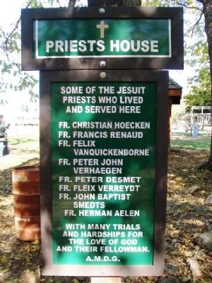
Priests House Marker
| 101 ► Kansas, Linn County, Centerville — Priests House — |
| 102 ► Kansas, Linn County, Centerville — Saint Kateri Tekakwitha Onkweonweke Katsitsiio Teotsitsianekaron — (The Fairest Flower That Ever Bloomed Among The Red Men) — 1656 - 1680 (Died at Age 24) — |
| 103 ► Kansas, Linn County, Centerville — St. Mary's Mission — St. Philippine Duchesne Memorial Park — |
| On 1525th Road, on the left when traveling west. | |||
| 104 ► Kansas, Linn County, Centerville — St. Philippine Duchesne Memorial and Historical Park — |
| Near West 1525th Road. | |||
| 105 ► Kansas, Linn County, Trading Post — Sounds of the byway...moccasins and tears. — Frontier Military Historic Byway — |
| 106 ► Kansas, Logan County, Oakley — Inhabitants of the Kansas Plains — |
| On U.S. 83 at 2nd Street, on the left when traveling north on U.S. 83. | |||
| 107 ► Kansas, Lyon County, Emporia — Prairie Passages — |
| On Industrial Road at U.S. 50, on the left when traveling south on Industrial Road. | |||
| 108 ► Kansas, McPherson County, Elyria — 33 — Kansas Indian Treaty — |
| On Old U.S. 81, 0.3 miles south of Comanche Road, on the right when traveling south. | |||
| 109 ► Kansas, McPherson County, Elyria — Sora Kansas Creek — Santa Fe Trail — 1822 - 1872 — |
| On Old U.S. 81, 0.3 miles south of Comanche Road, on the right when traveling south. | |||
| 110 ► Kansas, Meade County, Meade — 78 — The Lone Tree Incident — |
| On U.S. 54 at milepost 42.5, on the right when traveling east. | |||
| 111 ► Kansas, Miami County, Osawatomie — The Potawatomi Trail of Death — Indiana to Kansas — September 3, 1838 to November 4, 1838 — |
| On 6th Street at Lincoln Avenue, on the left when traveling north on 6th Street. | |||
| 112 ► Kansas, Miami County, Paola — Baptiste & Mary Ann Peoria — |
| On Peoria Street at Silver Street, on the right when traveling east on Peoria Street. | |||
| 113 ► Kansas, Mitchell County, Cawker City — 36 — Waconda (Great Spirit Spring) |
| On U.S. 24, 2 miles east of Cawker City, on the right when traveling east. Reported missing. | |||
| 114 ► Kansas, Mitchell County, Cawker City — Waconda Springs — |
| On Wisconsin Street (U.S. 24) 2.3 miles east of Ash Street, on the right when traveling east. | |||
| 115 ► Kansas, Mitchell County, Glen Elder State Park — Waconda Springs / Glen Elder State Park — |
| 116 ► Kansas, Montgomery County, Caney — Black Dog Trail Campsite — |
| On 4th Avenue near Ridgeway Street, on the right when traveling east. | |||
| 117 ► Kansas, Montgomery County, Caney — Captain Richard C. Mason — PeaRidge Battlefield Arkansas 1862 — |
| 118 ► Kansas, Montgomery County, Elk City — Elk City Kansas — |
| On East Hickory Street (County Road 5250) 0.1 miles west of U.S. 160, on the right when traveling west. | |||
| 119 ► Kansas, Montgomery County, Independence — 56 — Drum Creek and the Civil War — |
| On Main Street (U.S. 160) at 4410th Street, on the left when traveling east on Main Street. | |||
| 120 ► Kansas, Morris County, Council Grove — Council Grove — Flint Hills Scenic Byway — |
| On Main Street (U.S. 56) near Neosho Street (Kansas Highway 177), on the left when traveling west. | |||
| 121 ► Kansas, Morris County, Council Grove — 21 — Council Grove — |
| 122 ► Kansas, Morris County, Council Grove — Council Oak — August 10, 1825 — |
| On Main Street (U.S. 56) near Union Street, on the left when traveling east. | |||
| 123 ► Kansas, Morris County, Council Grove — Council Oak — |
| On Main Street (U.S. 56) near 2nd Street, on the left when traveling east. | |||
| 124 ► Kansas, Morris County, Council Grove — Council Oak Acorn — Arbor Day 1931 — |
| On Columbia Street at Adams Street, on the right when traveling west on Columbia Street. | |||
| 125 ► Kansas, Morris County, Council Grove — Father Juan Padilla Monument — |
| On 900th Road, 1 mile west of Neosho Street (Kansas Highway 177), on the right when traveling south. | |||
| 126 ► Kansas, Morris County, Council Grove — Guardian of the Grove — Created by — Thomas Mark Sampsel — |
| On Main Street (U.S. 56) at Union Street, on the right when traveling west on Main Street. | |||
| 127 ► Kansas, Morris County, Council Grove — Kaw House Reconstructed — |
| On Mission Street near Huffaker Street, on the right when traveling north. | |||
| 128 ► Kansas, Morris County, Council Grove — Kaw Mission — A School for the Kaws — |
| On Mission Street near Huffaker Street, on the right when traveling north. | |||
| 129 ► Kansas, Morris County, Council Grove — Madonna of the Trail — |
| On Main Street (U.S. 56) at Union Street, on the left when traveling east on Main Street. | |||
| 130 ► Kansas, Morris County, Council Grove — Morris County 4-H Fairgrounds Circle of History — |
| On U.S. 56, on the left when traveling east. | |||
| 131 ► Kansas, Morris County, Council Grove — Old Bell — 1863 — |
| On North Belfry Street near Columbia Street, on the right when traveling north. | |||
| 132 ► Kansas, Morris County, Council Grove — Pioneer Cowboy Jail — City Calaboose Since 1849 — |
| On Main Street (U.S. 56) at 5th Street, on the left when traveling east on Main Street. | |||
| 133 ► Kansas, Morris County, Council Grove — Santa Fe Trail / Council Grove — 1822 - 1872 — |
| On Main Street (U.S. 56) near 2nd Street, on the left when traveling east. | |||
| 134 ► Kansas, Neosho County, Chanute — Osage City — |
| On Santa Fe Avenue at Little Turkey Creek, on the right when traveling south on Santa Fe Avenue. | |||
| 135 ► Kansas, Neosho County, Erie — 52 — Mission Neosho — |
| On Pratt Road (U.S. 59) at 160th Road (Kansas Highway 146), on the right when traveling north on Pratt Road. | |||
| 136 ► Kansas, Neosho County, Erie — 52 — Osage Nation — |
| On Pratt Road (U.S. 59) at 160th Road (State Highway 146), on the right when traveling north on Pratt Road. | |||
| 137 ► Kansas, Neosho County, Parsons, Lincoln Township — Oak Grove & the Osage Trail — |
| On 20th Road, 5.5 miles east of Ottawa Road (U.S. 59), on the right when traveling east. | |||
| 138 ► Kansas, Neosho County, St. Paul — 51 — Osage Catholic Mission — |
| On Washington Street (State Highway 47) near Udall Road, on the right when traveling east. | |||
| 139 ► Kansas, Ottawa County, Delphos — Pike's Route — |
| On 42nd Road at Victory Road, on the right when traveling south on 42nd Road. | |||
| 140 ► Kansas, Pawnee County, Burdett, Browns Grove — Confrontation Ridge, April 14, 1867 — The Army / The Cheyenne & Lakota — |
| On North Road near U.S. 156, on the right when traveling west. | |||
| 141 ► Kansas, Pawnee County, Fort Larned National Historic Site — Doesn't Every Fort Have a Wall? — |
| 142 ► Kansas, Pawnee County, Larned — Ak'a Onikashin ga • People of the Southwind — |
| On State Highway 156, on the left when traveling west. | |||
| 143 ► Kansas, Pottawatomie County, Belvue — 19 — The Vieux Crossing — |
| On Camp Creek Road at U.S. 24, on the right when traveling east on Camp Creek Road. | |||
| 144 ► Kansas, Pottawatomie County, Saint Marys — The Great Military Road — |
| On East Bertrand Avenue (U.S. 24) at Grand Avenue, on the right when traveling east on East Bertrand Avenue. | |||
| 145 ► Kansas, Pottawatomie County, St. Marys — Indian Pay Station Museum — St. Marys Historical Society — |
| On Mission Street, on the right when traveling east. | |||
| 146 ► Kansas, Pottawatomie County, St. Marys — Potawatomi Pay Station & St. Marys Mission — |
| On West Bertrand Avenue (U.S. 24) west of North 6th Street, on the right when traveling west. | |||
| 147 ► Kansas, Pottawatomie County, St. Marys — 18 — St. Marys — |
| On East Bertrand Street (U.S. 24) at Grand Avenue, on the right when traveling east on East Bertrand Street. | |||
| 148 ► Kansas, Pottawatomie County, Wamego — 107 — Vieux Cemetery — |
| On Oregon Trail Road, 0.8 miles west of Onaga Road, on the right when traveling west. | |||
| 149 ► Kansas, Pottawatomie County, Westmoreland — Archeological Site 14-PO1311 — |
| On The Road to Oz Highway (State Highway 99), on the left when traveling south. | |||
| 150 ► Kansas, Rawlins County, Atwood — 85 — Frontier in Rawlins County — |
| On Lake Road at North 2nd Street, on the left when traveling east on Lake Road. | |||
| 151 ► Kansas, Republic County, Republic — US Flag Raised over Pawnee Republic — |
| Near Pawnee Trail. | |||
| 152 ► Kansas, Republic County, Scandia — 34 — Country of the Pawnee — |
| On U.S. 36 near Cloud Street, on the left when traveling west. | |||
| 153 ► Kansas, Rice County, Lyons — 68 — Coronado and Quivira — |
| On Avenue M (U.S. 56) at 12th Road, on the left when traveling west on Avenue M. | |||
| 154 ► Kansas, Rice County, Lyons — Cow Creek Station — |
| On Avenue M (U.S. 56) near 12th Road, on the left when traveling west. | |||
| 155 ► Kansas, Rice County, Lyons — Fray Juan de Padilla — |
| On Avenue M (U.S. 56) near 12th Road, on the left when traveling west. | |||
| 156 ► Kansas, Rice County, Lyons — Rice County Historical Mural — |
| On West Avenue South south of West Main Street (U.S. 56), on the right when traveling south. | |||
| 157 ► Kansas, Riley County, Manhattan — Harahey — |
| 158 ► Kansas, Russell County, Russell — The Arrival of the Railroad — |
| On Wichita Avenue (Business U.S. 40) east of Jay Street, on the left when traveling east. | |||
| 159 ► Kansas, Saline County, Salina — Col. William A. Phillips — Founder of Salina, Kansas — Col. 3rd Cherokee Indian Reg. — |
| On Oakdale Drive, on the left when traveling south. | |||
| 160 ► Kansas, Scott County, Scott City — 81(A) — El Quartelejo — |
| On U.S. 83, 0.5 miles north of Kansas Highway 95, on the left when traveling north. | |||
| 161 ► Kansas, Scott County, Scott State Park — Battle Canyon, 1878 — |
| 162 ► Kansas, Scott County, Scott State Park — 81(B) — El Cuartelejo — |
| On West Scott Lake Drive, on the right when traveling north. | |||
| 163 ► Kansas, Scott County, Scott State Park — El Cuartelejo Archeology — |
| 164 ► Kansas, Scott County, Scott State Park — El Quartelejo — |
| On West Scott Lake Drive, on the right when traveling north. | |||
| 165 ► Kansas, Scott County, Scott State Park — Plains Apache at El Cuartelejo — |
| 166 ► Kansas, Scott County, Scott State Park — Pueblo Floor Plan — |
| 167 ► Kansas, Sedgwick County, Park City — 64 — Indian Treaties of 1865 — |
| On Broadway south of 63rd Street, on the left when traveling north. | |||
| 168 ► Kansas, Sedgwick County, Wichita — "Minisa" Bridge — 1932 — |
| On West 13th Street North at the Little Arkansas River, on the right when traveling west on West 13th Street North. | |||
| 169 ► Kansas, Sedgwick County, Wichita — 1854 Treaty Oration Excerpt — Chief Seattle of the Suquamish — American Indian Trail Walk Path — |
| 170 ► Kansas, Sedgwick County, Wichita — Bicentennial Flag Memorial — Introduction — |
| 171 ► Kansas, Sedgwick County, Wichita — Buffalo — The Source of Life — Plains Indians Life, Beliefs and Practices — |
| 172 ► Kansas, Sedgwick County, Wichita — Ceremonial Pipes — The Ceremonial Pipe — Plains Indians Life, Beliefs and Practices — |
| 173 ► Kansas, Sedgwick County, Wichita — Chiefs — A Title of Honor — Plains Indians Life, Beliefs and Practices — |
| 174 ► Kansas, Sedgwick County, Wichita — Circle of Life — |
| 175 ► Kansas, Sedgwick County, Wichita — Dream Animals — The Strength of the Shield — Plains Indians Life, Beliefs and Practices — |
| 176 ► Kansas, Sedgwick County, Wichita — Eagles — Lords of the Air — Plains Indians Life, Beliefs and Practices — |
| 177 ► Kansas, Sedgwick County, Wichita — Keeper of the Plains — |
| On Seneca Street near Central Avenue, on the right when traveling north. | |||
| 178 ► Kansas, Sedgwick County, Wichita — Keeper of the Plains — Blackbear Bosin — American Indian Trail Walk Path — |
| 179 ► Kansas, Sedgwick County, Wichita — North High School Indian Head — |
| On 13th Street North at Rochester Street, on the right when traveling west on 13th Street North. | |||
| 180 ► Kansas, Sedgwick County, Wichita — Stars and Stripes (1818) — |
| 181 ► Kansas, Sedgwick County, Wichita — Stories — The Wisdom of Storytelling — Plains Indians Life, Beliefs and Practices — |
| 182 ► Kansas, Sedgwick County, Wichita — Tipis — A Mobile World — Plains Indians Life, Beliefs and Practices — |
| 183 ► Kansas, Sedgwick County, Wichita — Tribes — Plains Indians Life, Beliefs and Practices — |
| 184 ► Kansas, Sedgwick County, Wichita — Way of the Horse — A Race of Mounted Warriors — Plains Indians Life, Beliefs and Practices — |
| 185 ► Kansas, Sedgwick County, Wichita — Women — Esteemed Partners — Plains Indians Life, Beliefs and Practices — |
| 186 ► Kansas, Sedgwick County, Wichita, Riverside — Ceremony — Sacred Songs and Objects — Plains Indians Life, Beliefs and Practices — |
| 187 ► Kansas, Sedgwick County, Wichita, Riverside — Confluence of the Big and Little Arkansas Rivers — |
| On Stackman Drive at Sim Park Drive, on the right when traveling north on Stackman Drive. | |||
| 188 ► Kansas, Sedgwick County, Wichita, Riverside — Warriors — Their Natural Weapons — Plains Indians Life, Beliefs and Practices — |
| 189 ► Kansas, Shawnee County, Topeka — 15 — Capital City of Kansas — |
| On SW 10th Avenue at SW Harrison Street, on the right when traveling east on SW 10th Avenue. | |||
| 190 ► Kansas, Shawnee County, Topeka — Charles Curtis — Vice-President of the United States — 1929-1933 — |
| 191 ► Kansas, Shawnee County, Topeka — Charles Curtis — Vice-President , United States — 1929 - 1933 — |
| 192 ► Kansas, Shawnee County, Topeka — 120 — Fool Chief's Village — |
| On NW Menokin Road at U.S. 24 on NW Menokin Road. | |||
| 193 ► Kansas, Shawnee County, Topeka — Home of Charles Curtis — |
| On SW Topeka Boulevard (U.S. 75) at SW 11th Street, on the right when traveling south on SW Topeka Boulevard. | |||
| 194 ► Kansas, Shawnee County, Topeka — Kansas Children — |
| 195 ► Kansas, Shawnee County, Topeka — Kansas History — |
| 196 ► Kansas, Shawnee County, Topeka — Mission Kitchen Garden — |
| 197 ► Kansas, Shawnee County, Topeka — Potawatomie Baptist Manual Labor Training School — |
| 198 ► Kansas, Shawnee County, Topeka — The Kansa Tribe — |
| 199 ► Kansas, Shawnee County, Topeka — Trails across Kansas — |
| 200 ► Kansas, Shawnee County, Topeka — Ward-Meade Home — 1870 — |
226 entries matched your criteria. Entries 101 through 200 are listed above. ⊲ Previous 100 — The final 26 ⊳