Civil War Dead
An estimated 700,000 Union and Confederate soldiers died in the Civil War (1861-1865). As the death toll rose, the U.S. government struggled with the urgent but unplanned need to bury fallen Union troops. This propelled the . . . — — Map (db m98502) HM WM
This site marks the first interment in
Forest Home Cemetery in August, 1850
This memorial is dedicated in
recognition of Forest Home Cemetery’s
continued commitment to preserve and
maintain the history of this community
Memorial Day May . . . — — Map (db m98580) HM
On Forest Home Avenue at 26th Street, on the left when traveling west on Forest Home Avenue.
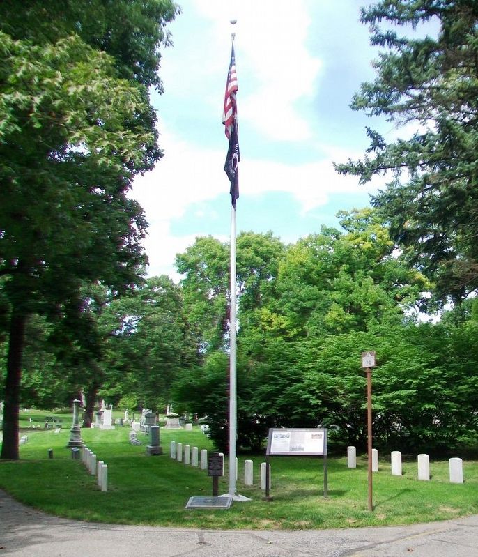
This is the final resting place for nearly one thousand men who fought for the Union in the Civil War, the most in any private cemetery in Wisconsin. Represented are dozens of Wisconsin volunteer units and those from at least 25 other states and . . . — — Map (db m98598) HM
When the Civil War broke out in 1861, enlisted in the 24th Reg. Wis. Vol. Inf. Participated in all the battles in which his regiment was engaged.
Was wounded at the Battle of Chic[k]amauga Ga. Sept. 19. 1863.
Again sever[e]ly wounded at the . . . — — Map (db m98611) WM
On West Bluemound Road, 0.2 miles east of Hawley Road, on the right when traveling east.
Consecrated on 1857 by the Most Rev. John Martin Henni, first archbishop of Milwaukee, Calvary Cemetery is the final resting place for more than 300 Union Civil War veterans including two Medal of Honor recipients: Boatswain’s Mate John Breen, USS . . . — — Map (db m119965) HM WM
Four score and seven years ago our fathers brought forth on this continent, a new nation, conceived in Liberty, and dedicated to the proposition that all men are created equal.
Now we are engaged in a great civil war, testing whether that nation, . . . — — Map (db m38459) HM
On Mitchell Boulevard near General Wolcott Boulevard, on the right when traveling south.
The National Asylum for Disabled Volunteer Soldiers was established by Congressional legislation and approved by President Abraham Lincoln on March 3, 1865. Its purpose was "...to care for him who shall have borne the battle..." as stated in . . . — — Map (db m77416) HM
"The markers in this memorial area
honor veterans whose remains
have not been recovered or
identified, were buried at sea,
donated to science, or cremated
and the ashes scattered." — — Map (db m38437) HM
Near North Lake Drive at East Locust Street, on the right when traveling north.
The last of a group of Indian Mounds formerly located on a Stone Age village site near this spot and destroyed in recent years. Several were of larger size. Also the last of many fine groups of burial, linear, and animal shaped mounds formerly . . . — — Map (db m68031) HM
On East Norwich Avenue at South Barland Avenue, on the right when traveling east on East Norwich Avenue.
Lake Protestant Cemetery was founded as a farm cemetery in the 1840s on Jared Thompson’s land and was incorporated in 1855. This three-quarter acre cemetery is divided into forty-two lots. The earliest burial dates to 1846, and the most recent . . . — — Map (db m155525) HM
Near North 87th Street, 0.5 miles north of West Watertown Plank Road, on the right when traveling north.
The ground before you contains the mortal remains of approximately 200 souls who died at the Milwaukee County Asylum / Hospital for the Insane. These burial grounds were open from March 1880 – November 1914. Patients without financial means or . . . — — Map (db m51465) HM
On North 87th Street, 0.2 miles north of West Watertown Plank Road, on the left when traveling north.
This site, also known as Potter’s Field was originally a pasture on the Milwaukee County Farm. Between 1872 and 1974, this four acre field became the final resting place for 4000 of the estimated 7500 children and adults buried on the Milwaukee . . . — — Map (db m51464) HM
On West Capitol Drive at U.S. 45, on the right when traveling west on West Capitol Drive.
This acre was purchased from Mr. Clarke Brookins by the Oak Hill Burying Ground Assoc. Burials began in 1839. Civil War vets Johann Bahler and Dr. Levi Halsted are buried here with other Wauwatosa pioneers. — — Map (db m46668) HM
Patriot James Morgan was born April 5, 1748, in Frederick County, Virginia. At the age of 30, Morgan enlisted in the Revolution for a three-month tour in Colonel John Evan’s Virginia Regiment. He served with General McIntosh’s campaign in the Ohio . . . — — Map (db m31763) HM
On South 84th Street just west of Dairy Lane, on the right when traveling east.
Ho-Chunk histories indicate that this area has long been an important gathering place known as Tee Sisikeja (Bad Waters Village). Here, ancestors of the Ho-Chunk constructed burial sites for loved ones in the form of mounds, a practice that dates . . . — — Map (db m208429) HM
Near East Montgomery Street, 0.4 miles east of Angelo Road (Wisconsin Highway 21).
On the 223 acres which surround this peaceful place, many hundreds of children whose young lives were touched by tragedy and misfortune lived here at the Wisconsin Child Center, formerly known as the State Public School for Dependent and Neglected . . . — — Map (db m26634) HM
At this site approximately 4,500 years ago, Wisconsin Indians gathered to bury their dead. Because of their use of copper tools, weapons and ornaments, this group became known as the Old Copper people. They fashioned spearpoints, knives and . . . — — Map (db m58143) HM
On Thelen Avenue south of West 13th Street, on the right when traveling south.
In this area, part of the Statesburg settlement, are the graves of Hendrick Aupaumut and Jacob Konkapot, Stockbridge Indians of Massachusetts. Captain Aupaumut won the notice of George Washington. Able tribal counselor, he served as envoy to western . . . — — Map (db m22449) HM
Near Church Place, 0.1 miles south of Freistadt Road, on the right when traveling south.
History of the Cemetery Outhouse
The Cemetery Outhouse is a typical building from the turn-of-the-century (i.e. 1900). Because of the more or less "public" use of this building it was partitioned into two sections. One entrance was for the . . . — — Map (db m95658) HM
Recovered from Lake Michigan 1900
Erected to the Memory
of the
Passengers and Crews who lost
their lives in the wrecks of the
Steamers Toledo and Niagara
wrecked off Port Washington, WIS.
1856 — — Map (db m118457) HM
On County Highway CC at 70th Avenue, on the left when traveling north on County Highway CC.
The restoration of this church and cemetery is in memory of the early pioneers who brought with them their Christian faith upon which they built their homes and communities.
Established 1872
Dedicated to early pioneers
This Swedish . . . — — Map (db m39752) HM
On County Road T south of Trout Creek Road, on the left when traveling north.
Early Norwegian immigrants settled Central Wisconsin in the mid-1800s and brought with them the traditional church architecture still found in the hills and fjords of their native land. South New Hope Church was chartered in 1888 when synod debates . . . — — Map (db m156507) HM
On South Lake Avenue (State Highway 13) north of Walnut Street, on the right when traveling north.
On July 27, 1894 forest fires racing through dry timber slashings descended on Phillips from three directions. Within a matter of hours the city of 2500 persons lay in smoldering ruins. More than 400 homes, the business district, a new tannery and . . . — — Map (db m47236) HM
John M. Anderson, elephant trainer with the Great Wallace Circus Show, died in Racine on June 3, 1898 at the age of 54 when he was killed by his elephant. — — Map (db m109266) HM
Mound Cemetery derives its name from the fourteen prehistoric Indian mounds found here.
On February 3, 1851 this land was purchased by Norman Clark and James Kinzie of the village of Racine, from Joseph Ouilmett the Indian of Wausau, . . . — — Map (db m68645) HM
On South Sylvania Avenue, 0.2 miles south of Braun Road, on the right when traveling south.
(obverse)
Patriot Helmont Kellogg was born on March 17, 1762 in New Hartford, Connecticut.
Helmont served four different hitches in the Connecticut Militia during the Revolution; as a drummer in 1777 in Colonel Adam's Regiment; for . . . — — Map (db m54068) HM
Near State Highway 80, 0.4 miles north of County Highway CC, on the right when traveling north.
In 1858 the land for St. Patrick's Church and Cemetery was donated to the congregation by Charles and Catherine Shields. The first church was erected in 1867. In 1904 an addition was added to accommodate a growing congregation. In 1924 the old . . . — — Map (db m42000) HM
On Brown Church Drive at Wisconsin Highway 130, on the right when traveling west on Brown Church Drive.
This land was purchased from Benjamin Winterburn in three parcels; the first in 1863 for plat 1 of the cemetery.
This was divided into 45 lots which were sold at $5.00 each. Land for the church site was purchased and the church was built in . . . — — Map (db m66803) HM
On Bradford Clinton Townline Road, 0.5 miles east of O'Riley Road, on the left when traveling east.
Philip Allen was born in Bridgewater, Massachusetts on July 9, 1757. At the outbreak of the revolution, 18-year-old Allen enlisted as his brother’s substitute in Captain Packard’s company of Colonel David Brewster’s regiment. Allen served in at . . . — — Map (db m33614) HM
On Water Street (State Highway 113) east of Mound Street, on the right when traveling east.
At this site was the village of Chief Car-A-Maue-Nee of the Winnebago Indians. Across the St. was his Council House in the midst of 7 effigy Earth mounds representing animals. In this area were about 90 effigies and conical mounds, second largest of . . . — — Map (db m65670) HM
Man Mound
has been designated a
National Historic Landmark
The Man Mound is nationally significant as a rare example of a human-shaped Effigy Mound. Effigy Mounds are earthen sculptures created in the shapes of . . . — — Map (db m141035) HM
Near Man Mound Road, 0.5 miles east of Trapp Road, on the right when traveling east. Reported permanently removed.
This huge likeness of a man is thought to represent a powerful Indian God. The aborigines who made it may have been the Effigy Mound Builders. These Indians lived here about 1000 years ago. Nearly 900 of their earthworks have been found in Sauk . . . — — Map (db m182854) HM
Near South 9th Street south of Panther Avenue, on the right when traveling south.
Within these fifteen acres of ancient woodland and winding stream lie 18 rare Indian burial mounds, dated about 500-750 A.D. Their prehistoric builders, ancestors of the Wisconsin Woodland Indians, are called the Effigy Mound People because . . . — — Map (db m32363) HM
Near Wisconsin Route 35 east of Hawk Street, on the right when traveling east.
Based on archaeological evidence, the first known inhabitants of Wisconsin were the Paleo-Indians and Archaic cultures. They lived as hunters and gatherers between 10,000 and 3000 years ago. They were followed by the Woodland culture which . . . — — Map (db m238865) HM
On County Road U, 0.6 miles south of County Road N, on the left when traveling south.
Nicholas and Hely Schwalen were among the first farmers in St. Croix County. They emigrated from Honsfeld, Prussia, in present day German-speaking Belgium. The brothers arrived in Racine, Wisconsin in 1848 and steadfastly worked their way to St. . . . — — Map (db m46122) HM
This German Evangelical Church was built in 1890. At that time every church had its cemetery. This small collection of gravestones represents our Heritage Center Church Cemetery. The stones are all from New Richmond. The tall memorial marker for . . . — — Map (db m158278) HM
On Great River Road (State Highway 35) 0.4 miles north of Main Street (State Highway 82), on the left when traveling north.
Named De Soto 1855.
The first Winnebago chief Winneshiek fought with British at Mackinac 1812, at Sandusky 1813 and helped McKay take Prairie du Chien from U.S. in 1814. He died at Lansing Iowa in 1848. Legend since 1855 claims his burial . . . — — Map (db m24712) HM
On Irish Ridge Road, 0.5 miles west of Parker Road, on the left when traveling west.
In 1867-68, at this site, on land donated by Patrick Donohoe in 1861, early Irish immigrants built a white frame church dedicated to St. Patrick. The location was called "Bad Axe" the original name of Vernon County.
The Church was dedicated in . . . — — Map (db m39239) HM
On County Highway UU, 0.8 miles west of Orlando Road, on the left when traveling west.
August 2 1832 twenty
picked Sacs were station-
ed here to decoy the US
Army northward and per-
mit the Indian main body
with women and children
to escape across the riv-
er. Fourteen of the out-
post were shot here wh-
ile . . . — — Map (db m32171) HM
On Dodge Street near Warren Street, on the right when traveling west.
The first cemetery in Lake Geneva. In 1837, seven men who were early landowners in section 36, gave land to the village for public purposes. They wanted areas for parks, churches, schools, & a cemetery. Thomas McKaig was hired to survey the land. . . . — — Map (db m241429) HM
On East Main Street at North Wakely Street, on the left when traveling east on East Main Street.
Two Revolutionary war veterans, Eli Pearce and Israel Ferris, are buried in this cemetery.
Born August 24, 1760, in Middleborough, Massachusetts, Eli Pierce enlisted April 13, 1776, and served six months in Col. Christopher Lippett's Rhode . . . — — Map (db m43483) HM
On Brookfield Road, 0.5 miles south of Capitol Drive.
Burial place of Yankee, English and German settlers. Part of Pioneer Joseph Ewbank land grant.
Noted grave: Nathan Hatch, Revolutionary War soldier who came west with sons, Hiram and Edmund, in 1840’s. Remains possibly moved from earlier family . . . — — Map (db m43582) HM
On Pilgrim Square Parkway, 0.1 miles north of West North Avenue, on the left when traveling north.
Burial place of Yankee and English settlers. It was first called Dixon or East Side Cemetery.
This was also the site of the first Dixon school house, which was burned and relocated south of North Avenue in the 1860’s.
This land was deeded . . . — — Map (db m43581) HM
On Brookfield Road, 0.5 miles Capitol Drive, on the right when traveling north.
Buried here is PVT. NATHAN HATCH, patriot who fought four tours of duty in the Continental Army 1776-1781
Born 16 Nov. 1757 at Attleboro, MA, he first enlisted July 1776 in Capt. Isaac Hodges Co. as Pvt. He was discharged Nov. 1780. He moved to . . . — — Map (db m33027) HM
Near Main Street (County Route VV) north of Huntington Street.
The two mounds in front of you are the only remaining Native American mounds in Merton. While surveying Merton in 1851, Increase Lapham found several other mound groups, including a very large bird-shaped effigy mound approximately 1/4 mile to the . . . — — Map (db m233299) HM
On North Cape Road at West Ryan Road, on the right when traveling south on North Cape Road.
Dedicated to Muskego’s most illustrious pioneer and first European settler, Luther Parker, who brought his wife Alletta and five children to Muskego by horse and wagon in 1836. Luther Parker was one of several responsible for secession of Waukesha . . . — — Map (db m43612) HM
On Janesville Road near Tess Corners Road, on the right when traveling east.
In 1857, twelve German families started a Protestant Mission church. They brought their Christian faith and German language from the old country to what is now Muskego. Their services were conducted in German and held once a month in a rented, one . . . — — Map (db m102113) HM
On Maple Avenue at Main Street, on the right when traveling north on Maple Avenue.
Melinda Ann (Warren) Weaver, B. Feb. 25, 1813 in New York State, married an English immigrant, John Weaver, in 1833. In the fall of 1836, with Melinda 7 months pregnant & leading two children the Weaver family took an Erie Canal boat to Buffalo, & a . . . — — Map (db m32873) HM
On Maple Avenue, 0.1 miles north of Main Street, on the right when traveling north.
Named for English martyr and saint. The parish was organized in 1842. The first church, 1844, stood at the southwest corner of God’s Acre. The first grave was there opened in that year. The edifice was dedicated by Bishop Jackson Kemper in 1866. The . . . — — Map (db m235805) HM
On Maple Avenue, 0.5 miles north of Main Street, on the right when traveling north.
This cemetery has multi names, most recent being “Redeemer United Church of Christ Cemetery”
Other names included “Zion Cemetery” “German Cemetery” “The German Zion Evangelical Church Cemetery” & . . . — — Map (db m43606) HM
John Dodge, one of Vernon’s four founding fathers, settled on this land in the fall of 1836. He purchased the land from the Federal government Sept. 20, 1838. Dodge made his home here until his death Aug. 29, 1858. The cemetery was established as a . . . — — Map (db m43588) HM
Near South Prairie Avenue, 0.2 miles north of Progress Avenue.
Erected to the memory of
1799 - Lyman Goodnow - 1884
First conductor of Wisconsin's underground railroad
In 1842 he conveyed Caroline Quarrels,
an escaped slave, to Canada and freedom. — — Map (db m44584) HM
Near Mill Street (Wisconsin Route 161) 0.5 miles west of North Main Street (Wisconsin Route 49).
Riverside Cemetery
While the Riverside Cemetery was not officially established until 1860, records indicate that a desire had been expressed to establish a cemetery at this location as early as 1857, while Mary McIntire (1816-1856) was the . . . — — Map (db m230890) HM
On State Highway 110 at Schoneck Road, on the left when traveling south on State Highway 110. Reported permanently removed.
Chief Waupaca, better known as Sam Wapuka, was a friendly Potawatomi Indian who lived in this vicinity about the time the first white men arrived. Although he was friendly to the settlers, his tribesmen were bitterly opposed to the invasion of the . . . — — Map (db m20634) HM
Near 6th Avenue at Beechnut Drive, on the left when traveling south.
The Whistler Mound Group and Enclosure originally consisted of 70 conical or round burial mounds and a low, earthen double enclosure. The site has never been scientifically investigated so the exact date of construction is unknown. Archaeologists, . . . — — Map (db m18192) HM
Near North Lake Street, 0.1 miles north of County Highway PP, on the right when traveling north. Reported permanently removed.
In 1730 the French Government decided to destroy the Fox village on the shore of this lake because of the depredations of the Foxes on the fur traders. Capt. Morand came up the river with a large force of French soldiers and Menominee warriors. The . . . — — Map (db m237968) HM
Near North Lake Street, 0.1 miles north of Jacobsen Road (County Highway PP), on the right when traveling north.
Prehistoric Indian Mound Replica
The last Indian mound of its kind in this area was located near this spot and known locally as the Hill of the Dead (Little Butte des Morts). This large mound, about sixty feet long, thirty feet wide, and . . . — — Map (db m71214) HM
Smith Park marks the northern limit of a large group of Native American burial mounds that once extended across the southeast shore of Doty Island. Three Effigy mounds are preserved here. The mounds were built between AD 700 and . . . — — Map (db m34399) HM
On North Clayton Avenue north of West American Drive, on the right when traveling north.
Near here is the "lost cemetery" of Saint Malachy Catholic Church (1849-1857), a mission church of log construction that served the local Irish community and Catholic Indians. Irish immigrants had come to Menasha to build dams, locks, and canals on . . . — — Map (db m20681) HM
Near Waukau Road (State Highway 116) 0.2 miles north of County Road E, on the right when traveling north.
The first section of the 20 acre Omro cemetery was donated by Milo Bushnell in 1846. In 1851, the Omro Cemetery Association was formed and this group superintended the growth of the cemetery in the years that followed. In the early 1880s, an effort . . . — — Map (db m162298) HM
On Grandview Road, 0.4 miles west of U.S. 45, on the right when traveling west.
Born on June 3, 1760, at Branford, Connecticut, Samuel N. Rogers, Sr., served several terms of enlistment with Captain Peck’s Company, Col. Roger Enos’ Regiment of the Connecticut Militia from 1777 to 1781. Following the war, he moved to New York . . . — — Map (db m11043) HM
On Bluff Drive, 1.3 miles west of County Highway E, on the right when traveling west.
These Indian burial sites are believed to be from descendants of the Winnebago and Prairie Band Potawatomi People.
The Potawatomi tradition was to build a grave house over the burial site. These grave houses are meant to deteriorate naturally . . . — — Map (db m6103) HM
On Day Road at Mill Creek Drive, on the left when traveling south on Day Road.
On January 13, 1906, forefathers from Norway established the church. The first pastor to serve was Reverend J.C. Hougum.
The church building was constructed in 1907 by Jorger Erickson, Knute Evenson, Ole Gunderson, Knute Jonsrud, Ole Jorstad, . . . — — Map (db m5045) HM
On 1st Avenue at East Jackson Street, on the left when traveling south on 1st Avenue.
This cemetery is the final resting place of men, women and children who settled Pittsville and the surrounding area. Some tombstones have weathered, some broke; some graves were never marked. Some stones were moved, but time and nature cannot remove . . . — — Map (db m7616) HM
Near Wisconsin River Drive (State Highway 73) north of Jefferson Avenue, on the right when traveling north.
The official Civil War roster of Company G of the Wisconsin 12th infantry lists two men named John Jones. They are listed as John Jones 1st and John Jones 2nd.
John Jones 1st gravesite has been located in the Ivy Green Cemetery in Bremerton, . . . — — Map (db m5954) HM
On Seneca Road, 0.6 miles west of Wisconsin River Drive / 2nd Avenue South (Wisconsin Highway 54 / 73), on the right when traveling west.
Persons interred in this county cemetery include former residents of the county poor farm and home for the aged as well as others requiring county burial between the years 1891 and 1948.
[names]
Donated by Martin Zurkowski — — Map (db m22580) HM
173 entries matched your criteria. Entries 101 through 173 are listed above. ⊲ Previous 100