After filtering for British Columbia, 37 entries match your criteria.
Railroads & Streetcars Topic
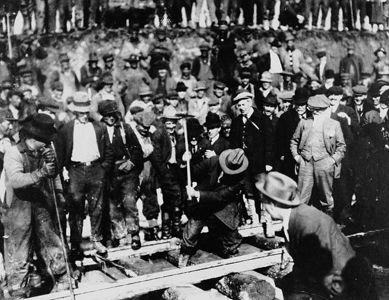
Unknown via British Columbia Archives (Public domain), April 7, 1914
Grand Trunk Pacific Railway — Last Spike
| 1 ► British Columbia, Bulkley-Nechako, Fort Fraser — Grand Trunk Pacific — |
| On Fourth Avenue/Yellowhead Highway (Provincial Highway 16) west of Telegraph Road, on the left when traveling west. | |||
| 2 ► British Columbia, Capital, Victoria, Downtown — Empress Hotel — L’Hotel Empress — |
| On Government Street. | |||
| 3 ► British Columbia, Capital, Victoria, Rockland — Craigdarroch — |
| 4 ► British Columbia, Capital, Victoria, Victoria West — Esquimalt and Nanaimo Railway Roundhouse — La Rotonde de l'Esquimalt and Nanaimo Railway — |
| Near Sitkum Road. | |||
| 5 ► British Columbia, Cariboo, Ten Mile Lake — Bridging the Cottonwood |
| Near Cariboo Highway (Provincial Highway 97) 2.2 kilometers south of Unity Road, on the left when traveling south. Reported missing. | |||
| 6 ► British Columbia, Central Kootenay, Salmo — Salmo — Mining and Logging — |
| On Crowsnest Highway (Provincial Highway 3) 3 kilometers south of Salmo Ski Hill Road, on the left when traveling south. | |||
| 7 ► British Columbia, Columbia-Shuswap, Craigellachie — Eagle Pass — |
| Near Trans-Canada Highway (Provincial Highway 1) 0.8 kilometers north of Lybarger Road, on the right when traveling north. | |||
| 8 ► British Columbia, Columbia-Shuswap, Craigellachie — The Last Spike — |
| Near Trans-Canada Highway (Provincial Highway 1) 0.8 kilometers north of Lybarger Road, on the right when traveling north. | |||
| 9 ► British Columbia, Columbia-Shuswap, Field — Baldwin #7717 Steam Locomotive — |
| Near Trans Canada Highway (Route 1) west of Whispering Wood Lane. | |||
| 10 ► British Columbia, Columbia-Shuswap, Field — Kicking Horse Pass — Le Col du Cheval-Qui-Rue — |
| On Transcanada Highway (National Route 1), on the right when traveling west. | |||
| 11 ► British Columbia, Columbia-Shuswap, Field — Mount Stephen House: The Early Years/Les premières années — Discovering the Canadian Alps / À la découverte des Alpes canadiennes — |
| Near Trans-Canada Highway (Provincial Highway 1) at Field Access Road. | |||
| 12 ► British Columbia, Columbia-Shuswap, Field — Mount Stephen House: The Heyday/Les beaux jours — A Worthy Stop on the Transcontinental/Un arrêt qui en vaut la peine le long de la Transcontinentale — |
| Near Trans-Canada Highway (Provincial Highway 1) at Field Access Road. | |||
| 13 ► British Columbia, Columbia-Shuswap, Field — Mount Stephen House: The Later Years/Les dernières années — A Gathering Place for Mountain Lovers / Un lieu de rencontre pour les amoureux de la montagne — |
| Near Trans-Canada Highway (Provincial Highway 1) at Field Access Road. | |||
| 14 ► British Columbia, Columbia-Shuswap, Golden — Kicking Horse Canyon — |
| Near Trans-Canada Highway (Provincial Highway 1) 11.5 kilometers east of Provincial Highway 95, on the left when traveling east. | |||
| 15 ► British Columbia, Columbia-Shuswap, Rogers Pass — Glacier House — |
| Near Trans-Canada Highway (Provincial Highway 1) 85 kilometers west of Provincial Highway 95. | |||
| 16 ► British Columbia, Columbia-Shuswap, Rogers Pass — The Loops — |
| On Trans-Canada Highway (Provincial Highway 1), on the right when traveling east. | |||
| 17 ► British Columbia, East Kootenay, Cranbrook — Railway Centennial — The Crowsnest Railway Route of the C.P.R. — 1898 — |
| On Van Horne Street South (Provincial Highway 3) south of 5th Avenue South, on the right when traveling south. | |||
| 18 ► British Columbia, East Kootenay, Moyie — St. Eugene Mine — |
| On Crowsnest Highway (Provincial Highway 3/95) 0.3 kilometers south of Half Moon Avenue, on the right when traveling south. | |||
| 19 ► British Columbia, Fraser-Fort George, Canoe River — Canoe River Tragedy — |
| On Southern Yellowhead Highway (Provincial Highway 5) 2.4 kilometers south of Bear Road, on the left when traveling south. | |||
| 20 ► British Columbia, Fraser-Fort George, Jasper — Yellowhead Pass — |
| Near Yellowhead Highway (Provincial Highway 16) at British Columbia-Alberta boundary line, on the right when traveling west. | |||
| 21 ► British Columbia, Fraser-Fort George, Lucerne — The Yellowhead Pass / Le col Tête-Jaune — |
| On Yellowhead Highway (Provincial Highway 16) 24.8 kilometers west of Icefields Parkway (Provincial Highway 93), on the right when traveling west. | |||
| 22 ► British Columbia, Greater Vancouver, North Vancouver — Pacific Great Eastern Railway Station — Protected Heritage Building - 1913 — |
| Near Lonsdale Avenue at Carrie Cates Court. | |||
| 23 ► British Columbia, Greater Vancouver, Vancouver, Central Vancouver — Here Stood Hamilton — |
| On West Hastings Street close to Hamilton Street. | |||
| 24 ► British Columbia, Kootenay Boundary, Christina Lake — Cascade — Gateway to the Boundary Country — |
| On British Columbia 395, 0.1 kilometers east of Crowsnest Highway (Provincial Highway 3), on the left when traveling east. | |||
| 25 ► British Columbia, Kootenay Boundary, Eholt — Eholt — Divisional Point of the Boundary — |
| On Crowsnest Highway (Provincial Highway 3) 2 kilometers west of Wilgas Lake Rest Area, on the left when traveling west. | |||
| 26 ► British Columbia, Kootenay Boundary, Midway — Kettle Valley Railroad — |
| On Crowsnest Highway (Provincial Highway 3) just west of Beamish Street, on the right when traveling west. | |||
| 27 ► British Columbia, Kootenay Boundary, Midway — Midway — Railways and Hotels — |
| On 5th Avenue at Florence Street, on the right when traveling east on 5th Avenue. | |||
| 28 ► British Columbia, Metro Vancouver, Port Moody — Port Moody |
| On Esplanade Avenue, 0.4 kilometers north of Murray Street, on the right when traveling north. Reported missing. | |||
| 29 ► British Columbia, Metro Vancouver, Vancouver, Central Vancouver — Canada Pacific Railway Station — City of Vancouver Heritage Building — |
| On Seymour Street. | |||
| 30 ► British Columbia, Metro Vancouver, Vancouver, Central Vancouver — Canada Place — |
| On Canada Place. | |||
| 31 ► British Columbia, Metro Vancouver, Vancouver, Strathcona — Canadian Northern Railway Station — City of Vancouver Heritage Building — |
| On Station Street. | |||
| 32 ► British Columbia, Okanagan-Similkameen, Keremeos — An American Railroad — |
| On Crowsnest Highway (Provincial Highway 3) 1.1 kilometers west of Ashnola Road, on the left when traveling west. | |||
| 33 ► British Columbia, Stikine Region, Fraser — Fraser — |
| On Klondike Highway, on the left when traveling south. | |||
| 34 ► British Columbia, Thompson-Nicola, Ashcroft — Canadian Northern Pacific's Last Spike — |
| On Trans-Canada Highway (National Highway 1) 1.7 kilometers south of Venables Valley Road, on the left when traveling south. | |||
| 35 ► British Columbia, Thompson-Nicola, Kamloops — Steamboat Saga — |
| On Trans-Canada Highway (Provincial Highway 1) 3.4 kilometers north of Holloway Drive, on the right when traveling north. | |||
| 36 ► British Columbia, Thompson-Nicola, Kamloops, Campbell Creek — Great Train Robbery — |
| Near Dallas Drive, on the left when traveling west. | |||
| 37 ► British Columbia, Thompson-Nicola, Kamloops, West End — Fur, Gold and Cattle — |
| Near Columbia Street West, 0.3 kilometers west of Grandview Terrace, on the right when traveling west. | |||