On Rosa L Parks Avenue at Early Street, on the right when traveling south on Rosa L Parks Avenue. Reported missing.
Bertha Pleasant Williams
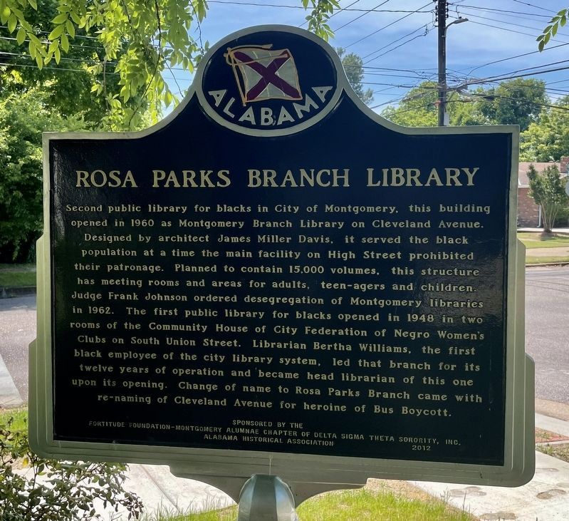
First black employee of Montgomery library system, Bertha Pleasant Williams received a high school degree in Fairfield, AL in 1939, a degree from Alabama State College (now ASU) in 1943, and, in 1949, a BLS degree . . . — — Map (db m71388) HM
On North Lawrence Street at Monroe Street, on the left when traveling north on North Lawrence Street.
Bill Traylor was born into an enslaved family on a Dallas County plantation. Around age ten, Traylor and his family were relocated to another plantation in neighboring Lowndes County, where they remained as laborers after Emancipation. Between 1939 . . . — — Map (db m205231) HM
On Hall Street at Tuttle Street, on the right when traveling north on Hall Street.
Nat King Cole was a jazz pianist, composer, and singer celebrated as an American popular music artist in the 1940s and 1950s.
He was born March 17, 1919 in Montgomery, Alabama as one of five children to Edward James Coles, a minister at Beulah . . . — — Map (db m71228) HM
On North Perry Street at Monroe Street, on the right when traveling south on North Perry Street. Reported permanently removed.
On a wall in this building,
"The Montgomery Theater"
Dan Emmett
first inscribed the score of Dixie for his minstrel orchestra.
H.F. Arnold
arranged it for band music and used it at the inauguration of
Jefferson Davis . . . — — Map (db m36574) HM
On Commerce Street at Dexter Avenue, on the left when traveling south on Commerce Street.
These decorative terra cotta lions heads, typical of the ornamentation used in commercial style architecture in the early part of the 20th century, were utilized by the First National Bank of Montgomery on the cornice of their 12 story building . . . — — Map (db m36646) HM
On Dexter Avenue at Decatur Street, on the right when traveling east on Dexter Avenue.
This street was named to honor Andrew Dexter one of the founders of Montgomery Along this street moved the inaugural parade of Jefferson Davis when he took the oath of office as President of the Confederate States of America February 18, 1861 . . . — — Map (db m36589) HM
On South Lawrence Street at High Street, on the left when traveling south on South Lawrence Street.
(side 1)
Juliette Hampton Morgan
Juliette Hampton Morgan was a white Montgomery, Alabama librarian whose privileged upbringing seemed unlikely to produce the determined civil rights activist that she became. Her letters to the . . . — — Map (db m71258) HM
On Hill Street at Starr Street, on the right when traveling south on Hill Street.
Lilly Baptist Church, established November, 1900 as a missionary church of Bethel Missionary Baptist. Originally located on St. Clair Street in a small frame building. Moved May 27, 1973, into new 1500-seat sanctuary at present location. Education . . . — — Map (db m71088) HM
On Lincoln Road, 0.1 miles north of Harrison Road, on the right when traveling north.
Side 1
Lincoln Cemetery
1907
In 1907 the American Securities Company opened Lincoln Cemetery for African Americans and Greenwood Cemetery for whites, the first commercial cemeteries in the city. Landscape design indicates . . . — — Map (db m71342) HM
Near North Bainbridge Street north of Dexter Avenue, on the right when traveling south.
Made in Alabama
Alabama has contributed to the nation's arts and
entertainment life since statehood. In the mid-twentieth
century, it shaped American culture in profound ways.
In a career launched from Montgomery radio and . . . — — Map (db m182641) HM
On West Fairview Avenue at Oak Street, on the right when traveling west on West Fairview Avenue.
The sculpture, made of corten steel, mimics the arched shape of the Edmund Pettus Bridge in Selma, AL. The silhouettes, cut as one solid shape, symbolize the marchers' determination to complete the 50-mile journey from Selma, AL and reach the steps . . . — — Map (db m153065) HM
On North Perry Street at Monroe Street, on the left when traveling south on North Perry Street.
Built 1936-37 Following a fire in 1932 that destroyed a 19th century City Hall, architect Frank Lockwood designed a replacement for the same site. With the Depression affecting all construction projects during the period, the city received . . . — — Map (db m36571) HM
On North Perry Street at Monroe Street, on the right when traveling south on North Perry Street. Reported missing.
Opened in Oct. 1860 as the South moved closer to secession, the theatre was significant in the social, cultural and political life of the city. In the early months, John Wilkes Booth performed here, Bryant Minstrels introduced "Dixie," which was . . . — — Map (db m247633) HM
On Montgomery Street at Molton Street, on the right when traveling west on Montgomery Street.
Sitting on the “Victory Ride” bus (up-front) after the 382-day Montgomery Bus Boycott and after the U.S. Supreme Court ruling ended segregation on buses
in Montgomery, Alabama.
Troy University opened the Rosa Parks Museum on December 1, 2000, . . . — — Map (db m194449) HM
On Montgomery Street, on the right when traveling west.
Side A
At the bus stop on this site on December 1, 1955, Mrs. Rosa Parks refused to give up her seat to boarding whites. This brought about her arrest, conviction, and fine. The Boycott began December 5, the day of Parks’ trial, as a . . . — — Map (db m86422) HM
On Maxwell Boulevard north of North Goldthwaite Street, on the left when traveling north.
This mural honors the late Grammy Award winner Nathaniel Adams Coles (1919-1965) later known as Nat King Cole, who was born in Montgomery, Alabama. Cole was an American jazz pianist and vocalist. He acted, performed on Broadway, recorded over 100 . . . — — Map (db m152651) HM
On Montgomery Street at Molton Street, on the right when traveling east on Montgomery Street.
The Violata Pax (Wounded Peace) Dove was created in 2006 by artist Fred NALL Hollis, a native son of Alabama.
The Dove was sculpted in white bronze and came to life in a foundry in Pietrasanta, Italy. It was generously gifted to Troy University by . . . — — Map (db m224864) HM
On Felder Avenue at Dunbar Street, on the right when traveling west on Felder Avenue.
F. Scott Fitzgerald, his wife Zelda and daughter Scottie lived in this house from October 1931 to April 1932.
During this period Fitzgerald worked on his novel Tender Is the Night and Zelda began her only novel, Save Me the . . . — — Map (db m69187) HM
On Old Carter Hill Road (County Route 85) 0.9 miles south of Old Pike Road (County Route 101), on the right when traveling south.
Built by William Matthews Marks, who immigrated from Oglethrope County, GA, on acreage purchased from the U.S. land office in Cahaba, AL for $1.25 per acre.
Foundation is pegged-together heart pine; framing is 3" by 9" timbers; mantles, dados, . . . — — Map (db m86472) HM
On 1st Avenue SE north of Johnston Street SE, on the right when traveling south.
A Century of Service
The Decatur Daily newspaper began publication in the basement of a building on the northeast corner of Moulton Street and Second Avenue on Feb. 26, 1912 to serve the adjacent towns of Decatur and New Decatur. Its web . . . — — Map (db m127338) HM
Oral tradition—stories passed from one generation to the next—long told the history of the Cherokee people. Sequoyah was the first to write it down. In 1921, about 90 miles east of Decatur, he created the Cherokee syllabary, a set of 85 . . . — — Map (db m140861) HM
On University Avenue west of Luther Drive, on the right when traveling east.
Donated to Troy University by Huo Bao Zhu During the visit of Chancellor Jack Hawkins, Jr. to Xian, China in April 2002.
The gift was made in celebration of the Sino-American 1-2-1 Joint Degree Program and as a lasting symbol of friendship between . . . — — Map (db m38930) HM
On University Avenue west of Luther Drive, on the left when traveling west.
Built in 1997, the Hall of Honor is named to honor three key leaders of Troy University: two Chancellors - Dr. Jack Hawkins, Jr. and Dr. Ralph W. Adams and the longtime leaders of the “Sound of the South” Marching Band and Director . . . — — Map (db m38942) HM
Near Luther Drive north of University Avenue, on the left when traveling west.
The Violata Pax (Wounded Peace) Dove symbolizes beauty and peace, sorrow and tragedy. Where you stand determines what you see.
The sculpture was originally commissioned as part of a post-earthquake renovation project for the Basilica of Saint . . . — — Map (db m111584) HM
On Alabama Route 165 north of Creek Trail, on the right when traveling north.
William Bartram, American's first native born artist - naturalist, passed through Russell County during the Revolutionary era, making the first scientific notations of its flora, fauna and inhabitants. As the appointed botanist of Britain's King . . . — — Map (db m164144) HM
Near 13th Street south of 3rd Avenue, on the right when traveling east.
The Creek Indians believed this section of the river was inhabited by a giant Tie-Snake, a mythical monster that snared the unwary and dragged them down into the watery underworld. The Tie-Snake was but one of many strange creatures and natural . . . — — Map (db m69067) HM
On Avenue A at College Street, on the right when traveling east on Avenue A.
History of York
Legend has it that York began at a blacksmith shop called Old Anvil, located at a crossroads a few miles northwest of the present city. Circa 1833, early settlers of a site located east of modern-day York on the old . . . — — Map (db m89719) HM
On North Broadway Avenue (Alabama Route 21) at West 8th Street, on the left when traveling north on North Broadway Avenue.
The Works Progress Administration (WPA), the Sylacauga community, and the state of Alabama, constructed this library in 1939. The building is the result of $16,588 from raised local funds including a $5000 donation for furnishings from the family of . . . — — Map (db m131721) HM
Near University Boulevard west of 6th Avenue, on the right when traveling west.
This bell tower, an enduring symbol of Alabama's first university, was erected in honor of President George H. Denny, under whose leadership (1911 to 1936) The University of Alabama gained national prominence. Conceived by Jerome M. Britchey and . . . — — Map (db m29610) HM
On Greensboro Avenue at Stillman Blvd, on the right when traveling south on Greensboro Avenue.
Organized 1820.
Moved to this site 1830.
Present structure erected 1921.
Under the leadership of Dr. Charles A. Stillman, (Minister, 1869-1895) it sponsored the founding of Stillman College in 1876. Its bell was the subject of a poem by . . . — — Map (db m35364) HM
On Cherokee Road, 0.4 miles south of Loop Road, on the right when traveling south.
Dr. Hudson Strode (1892-1976) – author, scholar, teacher and world traveler – and his beloved wife, Therese (1900-1986) lived here from 1941 until their deaths. Professor of English at the University of Alabama (1916-1961): he was renowned for his . . . — — Map (db m203509) HM
On Greensboro Avenue, on the right when traveling south.
Built 1835 by Alfred Battle; purchased 1875 by Bernard Friedman; willed to the city of Tuscaloosa 1965 by Hugo Friedman.
Traditionally a social and cultural center in Tuscaloosa, it was the residence of Virginia Tunstall Clay-Clopton, author of . . . — — Map (db m35368) HM
On Capstone Drive, on the right when traveling east.
Constructed as a guard house for the Alabama Corps of Cadets during the early 1860's, the Little Round House provided shelter from inclement weather for cadets on sentry duty. Until 1865, it also housed the University Drum Corps, which was composed . . . — — Map (db m25387) HM
On Blake Drive, on the right when traveling north.
To the memory of the brothers Seaborn M. Denson (1854-1936) and Thomas J. Denson (1863-1935) who devoted their lives and gifts to composing and teaching, over most of the south land, American religious folk music as embodied in “The Sacred Harp”. . . . — — Map (db m201731) HM
Raven is the Creator in many Alaska Native and American Indian legends. Elements from my different legends are incorporated into this sculpture including "Raven Stealing the Stars, Sun, and Moon." The human figures in the claws symbolize icons used . . . — — Map (db m72793) HM
For generations the Inuit people of Northern Canada, Greenland, and Alaska have constructed these rock monuments for hunting and navigational purposes. Our inuksuk is a giant version based on similar monuments found throughout the Arctic. . . . — — Map (db m69768) HM
On Main Street at West 4th Street, on the left when traveling north on Main Street.
Natives of Southeast Alaska have made totem poles such as this one for thousands of years.
This pole depicts four Haida clan stories. It was carved in 1940 by master carver John Wallace of Hydaburg. Described as "the last of the professional . . . — — Map (db m181736) HM
On Calhoun Avenue at West 4th Street, on the right when traveling north on Calhoun Avenue.
This totem pole tells the story of the harnessing of the atom. The pole was carved in 1967 by Tlingit carver Amos Wallace of Juneau. His Tlingit name was Jeet Yaaw Dustaa of the T'akdeintaan Clan of the X'áakw Hít Tlingit (Freshwater-marked Coho . . . — — Map (db m181737) HM
Fifty years after Patsy Ann met her last ship, admirers led by June Dawson organized the Friends of Patsy Ann. The group raised funds and commissioned a statue so Patsy Ann could once again greet visitors on the dock.
Sculpted by Ann Burke . . . — — Map (db m69663) HM
On Calhoun Avenue at Indian, on the left when traveling north on Calhoun Avenue.
Carved by Tlingit carvers:
Charlic Tagook — Klukwan
William Brown — Saxman
Carving began in 1939 / Carving was completed in 1940
Featured on this totem pole, from top to bottom, are Raven, a man, a giant cannibal (Guteel), . . . — — Map (db m181740) HM
On Main Street at 4th Street, on the right when traveling north on Main Street.
This statue was erected in 2017 to commemorate the 150th anniversary of the Treaty of Cession that was negotiated with Russia by Seward, resulting in the transfer of Alaska to the United States.
Seward is considered to be among the most important . . . — — Map (db m181743) HM
Near Mill Street, on the left when traveling east.
The cultural traditions and stylistic glories of Northwest Coast Native artists go back centuries. But the historical period of (obscured) and curating — mainly by non-Natives — is relatively short. Totem poles by tradition were private . . . — — Map (db m182030) HM
On Dock Street at Mill Street, on the right when traveling west on Dock Street.
Totem poles are carved to honor deceased ancestors, record history, social events, and oral tradition. They were never worshipped as religious objects.
This totem, carved by Israel Shotridge and raised in 1989, is a replica of the Chief . . . — — Map (db m79703) HM
Totem poles are carved to honor deceased ancestors record history, social events, and oral tradition. They were never worshipped as religious objects.
This totem is the second replication of the Chief Kyan Totem Pole. The original pole was . . . — — Map (db m70746) HM
Near Mill Street, on the left when traveling east.
A city arose at the mouth of Ketchikan Creek early in the 20th century, where Native people had camped for uncountable centuries to fish and hunt, houses, stores, hotels and sawmills uprooted the rainforest skyline in a sort of land-rush flurry of . . . — — Map (db m182027) HM
On Front Street at Water Street, on the right when traveling south on Front Street.
“Thundering Wings” — the title of local master carver Nathan Jackson's magnificent cedar monument, depicts the Tlingit native origin of Ketchikan's name, as told by Chief Reynold Denny of the Beaver Clan:
“About three hundred years ago the . . . — — Map (db m181908) HM
On West Main Street (U.S. 180/191), on the right when traveling west.
Built c.1915 & originally called the Apache Theatre, this adobe movie house once showed silent flickers with a hand-cranked projector. Renamed the El Rio in 1937, Round Valley's first theatre is still operating with its original popcorn machine. — — Map (db m36381) HM
On East Fremont Street (Arizona Route 80) at North 5th Street, on the right when traveling west on East Fremont Street.
Upon its completion on June 8, 1881 it became the largest, most elaborate theatre between El Paso, Texas and San Francisco, California.
Albert Schieffelin and William Harwood conceived and constructed a "first class opera house" for the citizens . . . — — Map (db m195859) HM
On North Railroad Avenue, on the right when traveling north.
[Marker mounted to the left of sculpture:]
Born December 31, 1920 to Horace and Faye Allen in Willcox, Rex Elvie Allen was cross-eyed at birth.
As a young boy, Rex sang in the barber shop on this very street. He and his Dad played . . . — — Map (db m28199) HM
On East Route 66 (U.S. 180) 0.1 miles east of North Park Drive, on the left when traveling east.
Built in 1931 by Dean Eldredge
Restored by Martin and Stacie Zanzucchi
Placed in the National Register of Historic Places
by the U.S. Department of the Interior on May 3, 1994
under the authority of Interior Secretary Bruce Babbitt
. . . — — Map (db m236440) HM
Designed as living quarters for Hopi artisans and as a place to sell Hopi crafts and souvenirs, this building represents the efforts of the Fred Harvey Company to revive Southwest Indian arts and crafts. Designed by Mary Jane Colter, the building . . . — — Map (db m39509) HM
The Kolb Brothers: daring, persistent, Grand Canyon legends. Their studio stands before you.
Ellsworth Kolb arrived here in 1901, Emery in 1902. First located in a tent, their photo business grew with Grand Canyon tourism. They eventually . . . — — Map (db m39549) HM
Near Desert View Drive (Arizona Route 64) 21.5 miles east of South Entrance Road.
Mary Colter's Desert View Watchtower creates an illusion of age. Concealed within the tower is an entirely different reality. Workers built a concrete and steel reinforced superstructure and then applied a veneer of native stone. The weathered . . . — — Map (db m169439) HM
On West Bill Williams Avenue / West Route 66 west of South 3rd Street, on the right when traveling east.
This entertainment center opened in 1912 and boasted a theater and room for dances and other events. It featured silent movies until 1930 when the first "talkies" in northern Arizona were shown, drawing notadle visitors like Will Rodgers. The . . . — — Map (db m33385) HM
An Ohio born dentist, Zane Grey spent many years under the Mogollon Rim, writing "To the Last Man" and a dozen other westerns with Arizona settings and characters. His prolific writings popularized the American cowboy as a taciturn, romantic . . . — — Map (db m67413) HM
On U.S. 60 east of Center Street, on the right when traveling west.
This desert town was made famous by the humor of Dick Wick Hall, healthseeker and operator of the laughing gas station. Hall's publication the Salome Sun was filled with extravagant tales of the desert's adaptation of species. He told of his frog . . . — — Map (db m31824) HM
On N. Greenfield Road at E. McKellips Road, on the right when traveling north on N. Greenfield Road.
Commemorative Air Force
Arizona Military Aviation
Walk of Honor
Proudly Recognizes
Barrett Tillman
Barrett Tillman (born 1948) is an award-winning author who has made significant contributions to aviation history. As a teenaged private . . . — — Map (db m102907) HM
This Frank Lloyd Wright designed Spire was originally part of the Frank Lloyd Wright designed Arizona State Capitol project from 1957. The Spire is 125 feet in height and was formally illuminated on 28 April 2004.
Taliesin Architects.
Arnold . . . — — Map (db m40619) HM
On Petrified Forest Road, on the right when traveling north.
For thousands of years, indigenous people have used rock faces as means of communication. Petroglyphs are images, symbols, or designs scratched, pecked, carved, or incised on the surface of rock. These features are like whispers from the past and . . . — — Map (db m68893) HM
On North Kinsley Avenue at West 2nd Street (Business Interstate 40), on the right when traveling south on North Kinsley Avenue.
This area was dedicated on September 11, 1999 as a tribute to the memorable song of the 1970's that made Winslow, Arizona a town to sing about on famous Route 66. — — Map (db m36329) HM
On South Scott Avenue, on the right when traveling south.
This cultural center was built through the efforts of the Saturday Morning Music Club. The grand opening October 28, 1927, starred violinist Jascha Heifetz. Many world-renowned artists followed upon the stage and in the galleries while local talent . . . — — Map (db m26442) HM
On South Meyer Avenue, on the right when traveling south.
Named for its founder, Carmen Soto Vásquez, this was one of the first theaters in Tucson devoted exclusively to the presentation of dramatic works in Spanish. From the opening night, May 20, 1915, with a performance of "Cerebro y . . . — — Map (db m83233) HM
DeGrazia Gallery
in the Sun
has been placed on the
National Register
of Historic Places
October 12, 2006
by the United States
Department of the Interior — — Map (db m29479) HM
On South Main Street, on the right when traveling north.
This is the original Tony, Jr. that was used for the memorial to Tom Mix which was dedicated on December 5, 1947, south of Florence.
The silhouette was designed by Fernando Arriola. This Tony, Jr. was stolen and missing for two years. The . . . — — Map (db m26672) HM
On West Gurley Street, on the left when traveling west.
This free-spirited Son of the West, sensitive to the changing era in which he lived, portrayed the western epic in marble and bronze. Our "Bucky O'Neill" monumental bronze is among his greatest works, and is acclaimed by art critics as one of the . . . — — Map (db m21165) HM
By the time MGM came to Sedona to film “Stay Away Joe” in 1967, audiences had fallen in love with the Elvis Presley movie formula. This contemporary western comedy spotlighted Elvis and other such distinguished co-stars as Burgess . . . — — Map (db m133568) HM
The first film shot in the Sedona area was Call of the Canyon, based on Zane Grey’s novel of the same name. This 1923 silent film was shot on location in Oak Creek Canyon near the site of Mayhew’s Lodge, and exposed the scenic wonders of the red . . . — — Map (db m133562) HM
The theme of arts and culture is a prominent one in Sedona for the period following World War II. Today, no city of its size in America has a finer arts pedigree than does Sedona. Home to both the Cowboy Artists of America and the Sedona Arts . . . — — Map (db m133573) HM
Near Old Post Road, 0.8 miles south of State Route 169.
The land passed from France to the United States in 1803 with the Louisiana Purchase. Arkansas then became a territory on March 2, 1819: the Post of Arkansas was designated its capital.
The Territorial Secretary Robert Crittendon, acting in . . . — — Map (db m108651) HM
"As legend has it"
They have a connection to Bentonville. Notice how well dressed they are. They should be after robbing the Craig & Son's General Store right in this neighborhood. Disappointed to only get $200, they helped themselves to fine . . . — — Map (db m236897) HM
On Jackson Place at McClure Avenue (County Road 923), on the left when traveling north on Jackson Place.
The Lowell Historical Museum was started with a Bicentennial Project Grant in 1976. Great community spirit and effort really stretched that seed money. Citizens donated or loaned cherished family heirlooms. Donated labor built display cases, sorted, . . . — — Map (db m224818) HM
On Elm Street at 3rd Street, on the right when traveling west on Elm Street.
This building is a pinnacle of A.O. Clarke's interweaving use of limestone and brick, Romanesque arches, and stained glass window detail. In 1996, the historic sanctuary was renovated and is one of the highlights of the church. The trademark steeple . . . — — Map (db m93331) HM
On 2nd Street south of Walnut Street (Arkansas Highway 12), on the right when traveling south.
The Rogers Victory Theater
Opened Monday, December 5, 1927, to a packed crowd of 750.
First Production: "American Beauty"
Notable Performers Over the Years:
Will Rogers, Conway Twitty
Designed by A.O. Clarke
Built by John Myler
It . . . — — Map (db m90740) HM
On State Highway 59 at East Patterson Street, on the right when traveling south on State Highway 59.
These stones from the foundation of a farm house at Breezy Point, one mile west of this spot, where the first Summer Institute of Linguistics (Camp Wycliffe) was held June-September 1934, stand here as a memorial to God's faithfulness. From that . . . — — Map (db m224973) HM
On North Walnut Street at East Rush Avenue, on the right when traveling north on North Walnut Street.
It is the former location of Hammerschmidt Lumber Co. and the First National Bank. It is now home of the Harrison flood of May 1961 mural (located inside) hand painted by Louis Fruend. This historic event commanded both national and international . . . — — Map (db m141869) HM
On West Stephenson Avenue at South Willow Street, on the left when traveling west on West Stephenson Avenue.
lt is one of the town's oldest commercial buildings and was built in 1876.
The original building was a two story wooden structure and was replaced
after the tum of the century with a one story rock building The facade has
been updated several . . . — — Map (db m141821) HM
On West Rush Avenue west of North Main Street, on the right when traveling west.
It was originally operated as a silent movie theater located on the West side of the square and owned by DE & Lulu Fitton. In 1929 JW Bass built a state of the art theater for talkies, leasing it back to the Fittons as the "New" Lyric. A mix of . . . — — Map (db m141840) HM
On West Stephenson Avenue at South Willow Street, on the left when traveling west on West Stephenson Avenue.
It was constructed shortly after 1900. Henry Starr, a well known outlaw & nephew of Belle Starr, attempted to rob the bank here in 1921. He was shot & killed by JW Myers, a former bank president, with a rifle hidden inside the vault. It was recorded . . . — — Map (db m141629) HM
On Main Street (State Highway 23) at Armstrong, on the left when traveling north on Main Street.
This three-story limestone building with metal-clad roof enclosing the top story was constructed in 1889 by Samuel L. Calif. For fifty years it served as a residence, general merchandise store, and boarding house. About 1948 the building was . . . — — Map (db m90699) HM
On Spring Street at Howell Avenue, on the right when traveling south on Spring Street.
Named for J. Emmett Harding, a photographer who began the tradition of making photographs of people in front of the spring as souvenirs. He built a small dwelling near the spring in the summer of 1879.
In 1879, the spring was accessed by a . . . — — Map (db m80151) HM
On Crossroads Road at Sims Road, on the right when traveling north on Crossroads Road.
The man known to the world as Johnny Cash was
born near here, in the home of his grandparents,
John Lewis and Rosanna Hurst Rivers, on
February 26, 1932. The family doctor was not
able to arrive in time for his birth, so a midwife,
Mrs. Grace . . . — — Map (db m170307) HM
On 1st Street (Arkansas Route 189) at Cedar Street, on the right when traveling west on 1st Street.
Johnny Cash moved with his parents and siblings
from Kingsland to Dyess, Arkansas in 1935 when he
was three years old. Johnny would often return to
the Kingsland area to visit or stay the night with
his Cash and Rivers relatives during his youth . . . — — Map (db m170310) HM
On East Magnolia Street (Arkansas Route 133) at Sycamore Street, on the right when traveling east on East Magnolia Street.
Cash Family Reunions
Johnny Cash often returned to Rison with his siblings
and father, Ray Cash, to attend annual family reunions
held at the old American Legion Hut, which formerly
stood across from the courthouse on Sycamore Street.
At . . . — — Map (db m185709) HM
On Main Street (Arkansas Route 35) north of School Drive, on the right when traveling north.
Johnny Cash Day in Arkansas
On March 20, 1976, Johnny Cash Day in Arkansas
was declared by proclamation issued by then-
Governor David Pryor. The festivities started in
Kingsland where Johnny and his family boarded a
special train, the . . . — — Map (db m170305) HM
On Petit Jean Mountain Road, on the left when traveling west.
When the Civilian Conservation Corps worked at Petit Jean in the 1930s, Dionicio Rodríguez, a
Mexican-born artist, sculpted this small bridge above a goldfish pond in a flower garden. He also sculpted a flower basket that is in rubble on the . . . — — Map (db m233676) HM
A glimpse of Arkansas's Prehistoric Heritage
The prehistoric rock art in Rock House Cave is
part of our heritage that can never be replaced.
Once it is gone, it is gone forever. It is up to us
to preserve these images for as long as . . . — — Map (db m233671) HM
On South 3rd Street at Main Street, on the left when traveling south on South 3rd Street.
In this small log building Albert Pike noted lawyer, poet and mason taught school in 1832. He later went to Little Rock to become editor of the Advocate. — — Map (db m96857) HM
On Main Street (Arkansas Route 59) west of North 11th Street, on the right when traveling west.
Freedom of Speech • Freedom of Worship
Freedom from Want • Freedom from Fear
This park, "Freedom Park" embodies the spirit of "Four Freedoms" by Norman Rockwell. Elements of the park were designed to reflect each of the Freedoms. The . . . — — Map (db m244099) HM
On South 4th Street at East Main Street, on the right when traveling south on South 4th Street.
Hebe, Greek goddess of youth and happiness was placed in her fountain on the Crawford County Courthouse lawn in 1908 by the Women's Village Improvement Society.
Repairs were made to both Hebe and fountain in memory of Robert Benham who served . . . — — Map (db m97670) HM
On North Currie Street east of Currie Avenue, on the left when traveling east.
Woolfolk is author of The History of Marion and History of Crittenden County, an award-winning newspaper editor, graduated from Memphis State Law School in 1985 at the age of 68, entered into private practice, and served as Marion . . . — — Map (db m116783) HM
On East Broadway Boulevard (U.S. 70) at South 2nd Street, on the right when traveling east on East Broadway Boulevard.
The inaugural broadcast of West Memphis' KWEM radio station on February 23, 1947, set the stage for what would become one of the pioneering platforms for Delta blues and the beginnings of the rock 'n' roll sound.
Here at 231 Broadway Boulevard in . . . — — Map (db m221358) HM
On East Broadway Avenue (U.S. 70) near Arkansas Route 38, on the left when traveling east.
In 1943, Morris Berger opened his legendary Plantation Inn
nightclub on this site in a former West Memphis gambling hall.
Billed as having the largest dance floor in the South, it became an
electrifying live-music destination for the region until . . . — — Map (db m221350) HM
Near Locust Avenue at Main Street, on the right when traveling south.
The first court house in Faulkner County was erected in 1873 on this site, the town of Conway then being known as Conway Station, on the Little Rock and Ft. Smith Railroad. The county was named for “Sandy” Faulkner of “Arkansas Traveler” fame. — — Map (db m229576) HM
Near U.S. 63 at Main Street (State Route 9), on the right when traveling north.
In 1919, George D. Hay, a young newspaper reporter for the Memphis Commercial Appeal, visited Mammoth Spring while on assignment. Before boarding the train back to the city, Hay was invited to a traditional Ozark musical and marveled at the . . . — — Map (db m192093) HM
On Whittington Ave. at Pine Street, on the right when traveling east on Whittington Ave..
Front of Obelisk
Born in Boston, Mass., came to Arkansas in 1826 to be printer for the Arkansas Gazette. In 1882 he moved to Hot Springs and in a two room log cabin established a general store, post office and lending library. He served as . . . — — Map (db m116351) HM
10609 entries matched your criteria. Entries 101 through 200 are listed above. ⊲ Previous 100 — Next 100 ⊳