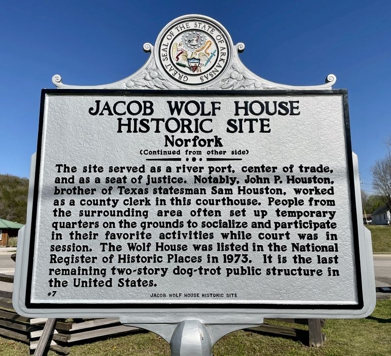
Jacob Wolf was a merchant, builder of log structures,
carpenter, and blacksmith. He was elected a
representative to Arkansas Territory's General
Assembly in 1826. The two-story dogtrot structure
constructed by Wolf in 1829 served as Izard . . . — — Map (db m170758) HM
This native stone tank was built in 1927 by the Linebarger brothers, under the supervision of Willard Braithwaite, to store water for summer cottages on the west side of Lake Bella Vista and later the Sunset Hotel. From 1927 to 1952, water from the . . . — — Map (db m224956) HM
This site
When the Clark County seat was
moved from Greenville to Arkadelphia
in 1842, until completion of a permanent
structure in 1844, a log building
which stood here served as court
house.
In 1860 a handsome two-story
brick . . . — — Map (db m234844) HM
Here, during Reconstruction years, were the offices of the Freedmen's Bureau. The building was, at different times, used as a harness shop, grocery store, barber shop and saloon, and for many years was a residence. — — Map (db m234853) HM
The Ott family of Parkin purchased the
Northern Ohio School from the Kelly family in
1959. The Kellys had been using the school
for a hay barn. The Ott family transformed
the old "barn" into a home by portioning
rooms and designing a living . . . — — Map (db m221318) HM
Constructed in 1904 as one of
the first office buildings
built to house the growing demand
for doctors offices and drug
stores. Remodeled as Wheatley
Hotel in mid 1950's. Bowling
alley in basement. — — Map (db m211128) HM
Construction projects undertaken during the 1920s and 1930s produced Hot Springs' most imposing structures. One of these, the completion of the Medical Arts Building, gave Hot Springs the distinction of having Arkansas' tallest building for several . . . — — Map (db m211053) HM
"In this house I learned to walk and talk. I learned to pray I learned to read and I learned to count by number cards my grandparents tacked on the kitchen window."
— President Clinton, Dedication Speech at
the . . . — — Map (db m161922) HM
Bill Clinton lived in this
house with his mother and
stepfather, Roger Clinton, from
1950 until 1953. During those
years, the future president
attended kindergarten and first
grade. Billy, as he was known
then, loved to play with . . . — — Map (db m159746) HM
The original structure was built in the year of 1893 and originally stood on a lot due south of the present location. Mr. and Mrs. Jacob Boyle bought the house in 1899 where they live and reared eleven children. In 1903 the Boyle family remodeled . . . — — Map (db m227629) HM
This building was constructed in 1904 by the federal government for the U.S. Post Office and the Batesville division of federal court for the Eastern District of Arkansas and was in use by federal agencies until 1974 when a new building was built a . . . — — Map (db m70558) HM
Site of first Court House of Izard
County. A small building of rough logs,
erected at Liberty in 1830. It stands in
what is now Baxter County. The second
court house was a frame building erected.
in 1834. The third was built at Mt. Olive
in . . . — — Map (db m170362) HM
Jacksonport became the county seat in 1853. Delayed by the Civil War, courthouse construction was not begun until 1869. It was completed in 1872.
When the county seat was moved to Newport in 1892, this building became a school, a cotton gin, the . . . — — Map (db m221217) HM
In 1818 a French trapper, Joseph Bonne landed on the south bank of the Arkansas River with his dog and gun near the location of the original Jefferson County Courthouse. Driven to this high bluff after flood waters had threatened his homesite at . . . — — Map (db m30576) HM
This property has been placed on the National Register of Historic Places by the United States Department of the Interior Owners Joe Mason Sr Peggy Mason — — Map (db m238098) HM
This property has been placed on the National Register of Historic Places by the United States Department of the Interior Owner Elizabeth Pickens — — Map (db m238097) HM
This property has been placed on the National Register of Historic Places by the United States Department of the Interior Owner: Gene Yarbrough Family — — Map (db m238096) HM
In the fall of 1851, three Mills brothers
headed west, one by water, one by land and
one to Texas. This brought Joel Mills wife,
Kitura Burke Bird and family from Henderson
Co., Tennessee to Sevier County, now known
as Little River County. . . . — — Map (db m121361) HM
A variety of colony services were housed in the original building on this site. When it burned in 1944, the theater and pop shop took its place. — — Map (db m207512) HM
Also called the Co-op Store, Trading Post, or The Big Store, this building carried everything colonist families needed. It burned in June 1957. — — Map (db m207494) HM
Built in 1909, the Bank of Osceola shared this building with various enterprises over the years, including a cotton brokerage firm and small movie theater. While much of the original architecture remains intact, four circular stone profiles of . . . — — Map (db m36670) HM
Built in 1915, the ground floor of this building once housed a barber shop and, later a hardware store. J.T. Coston, a Vanderbilt-educated attorney representing R.E.L. Wilson's farming interests, maintained his offices upstairs and was instrumental . . . — — Map (db m36453) HM
This corner building has been home to a drug store dating back to 1913. Once a two-story building with an elevated parapet and cornice, a fire in the early 1960s destroyed the second floor. The building's longest-running occupant is Newcomb's Drug . . . — — Map (db m36669) HM
Thomas J. Florida established the Florida Brothers Company in 1926, supplying farm and home loans to families along the Cotton Highway. Mr. Florida built this Art Deco-influenced structure in 1935, featuring Indiana limestone. The building . . . — — Map (db m36612) HM
In a spot once home to the Mercantile Opera House, this Classical Revival-style building was built in 1936 as Mississippi County Bank, showcasing Italian marble and rich wood throughout. Continuing to finance farming interests, First National Bank, . . . — — Map (db m36610) HM
Established in 1904 the Fred G. Patterson Store was famous as a general mercantile, specializing in shoes and cotton pick sacks. A shoe at the entrance indicated the store was open for business. In 1993 the family donated the buildings for use as a . . . — — Map (db m36425) HM
The Neo-Classical style 1920 building, designed by noted architect Uzzell Branson, originally housed Citizens Bank, then, First State Bank, a mercantile store, and City Hall. A citizens group, including Congressman W.J. Driver, opened Planters Bank . . . — — Map (db m36702) HM
The Works Progress Administration built this building, dedicated on May 29, 1936, as a new post office. The structure served the citizens of Osceola and the Cotton Highway as a post office until the Postal Service relocated to Johnson Street. . . . — — Map (db m36616) HM
The first court house in Perry County, created in 1840, was erected in 1841 in what is known as the Old Town of Perryville. This house was burned in 1850. In 1871 a court house was built on the present location, in the New Town of Perryville. This . . . — — Map (db m156774) HM
After the Union army arrived in July 1862, Helena was no longer part of the Confederacy. It was in Union hands and the Union commander made law and policy. The Moore-Hornor Home across the street was one of many in Helena seized by the Union army. . . . — — Map (db m108030) HM
Traveling road shows, vaudeville, dog-and-pony shows, mind
readers, magicians, bell ringers and boxing matches-they all
appeared live at Helena's Grand Opera House. In the days before
radio, movies and television live entertainment was king. . . . — — Map (db m107996) HM
Richard L. Kitchens Post No. 41 of the American Legion
World War I veterans founded the American Legion, a charitable organization, in 1919. That year, Helena's veterans founded Richard L. Kitchens Post No. 41. The name honors a . . . — — Map (db m108000) HM
The first court house in Pike County, built of logs, was erected on the site of the town of Murfreesboro, which was laid out as a site for the county seat in 1833. — — Map (db m121284) HM
Kirkbride Potts, with help from his wife Pamelia Logan Potts, designed and constructed this large and stately building between 1850 and 1858. He patterned it after the Classical Revival style he knew in his home state of Pennsylvania; however, he . . . — — Map (db m120871) HM
Arkansas State Capitol Built in 1836 The Ordinance of Secession was adopted here, May 6, 1861. This tablet placed by Memorial Chapter No. 48, United Daughters of the Confederacy, June 15, 1936, the one-hundredth birthday of this . . . — — Map (db m157495) HM
On this site (120 to 122 West Markham) in January 1868, a new Little Rock City Halil opened
after construction started in 1867. It served as the seat of Little Rock government until April
1908, when the present city hall opened. After city offices . . . — — Map (db m208861) HM
This building was the site of the Arkansas Secession Convention of 1861 and seat of the Confederate Government until 1863. After the capture of Little Rock by Federal forces the Old State House became headquarters of a Unionist State Government led . . . — — Map (db m157500) HM
This property has been placed on the National Register of Historic Places by the United States Department of the Interior Arkansas Historic Preservation Program — — Map (db m229495) HM
Shortly after Arkansas was admitted to the Union in 1836, the Federal government established the Little Rock Arsenal for the storage of munitions and weapons in defense of the frontier. Eventually, more than thirty buildings were constructed on . . . — — Map (db m117241) HM
The steel beams surrounding you form a "ghost structure” to represent
the essence of the courthouse as it stood during Davidsonville's prime.
Arkansas's first courthouse took three years to complete (1819-1822).
It was the most prominent . . . — — Map (db m170920) HM
This property has been placed on the National Register of Historic Places by the United States Department of the Interior Arkansas Historic Preservation Program Department of Arkansas Heritage — — Map (db m220449) HM
Built in 1893, the office of Dr. Dewell Gann, Sr. is the only known bauxite building in existence. The building was constructed by patients who could not afford to pay for services he had rendered them. The soft stone was dug from a farm nearby, . . . — — Map (db m96597) HM
This building, on the N.W. bastion of the wall, was the commissary of the fort. Built in 1839, used until 1871 when the fort was abandoned as a military post. From 1861-65 it served as a hospital, guard house, and refuge, now a museum.
Erected . . . — — Map (db m57921) HM
This facade is all the remains of the five story building occupied from 1907 to 1955 by Reynolds - Davis Wholesale Grocery Company. The building subsequently served Checker Transfer & Storage Company from 1957 thru 1988 as well as other tenants . . . — — Map (db m57919) HM
In 1870, ground was broken for the three-story Fishback Block on the site of Jeremiah Kannady's blacksmith shop which manufactured Bowie knives for the Confederate Army. The builder, future Gov. William Meade Fishback (1831-1903), named the 7,000 . . . — — Map (db m57918) HM
The first mention of this property is from 1838 when it was part of the brickyard that manufactured bricks to build the second Fort Smith. In 1877 the City Hotel was built here. In 1897, identical buildings were constructed to house the W.J. Murphy . . . — — Map (db m57917) HM
Home of W. W. Campbell and Victoria Mann
Campbell. W. W. Campbell was a bank, civic,
and agricultural leader in Eastern Arkansas.
influence extended nationally as reported in
the November, 1947, issue of Readers Digest
and the November, . . . — — Map (db m243314) HM
El Dorado
Masonic Temple
has been placed on the
National Register
of Historic Places
by the United States
Department of the Interior
Erected 1924 — — Map (db m121976) HM
This marks the site of the second court house built in Union County. Completed May 1st, 1848. The spot was originally a pond where ducks gathered in season. Emigrants in search of home sites frequently camped alongs its banks. It was filled in under . . . — — Map (db m121292) HM
Hill Hall was named for General Daniel Harvey
Hill, who served under General Robert E.
Lee during the Civil War and was the fourth
president of the university. The hall was
built in 1901 and opened for use as a men's
residence hall in early . . . — — Map (db m224342) HM
This Ante-Bellum Home was built on land granted to Washington County by an Act of Congress to build a court house, entitled “An Act for the Relief of Fayetteville, in the Territory of Arkansas,” and signed June 26, 1834 by . . . — — Map (db m59911) HM
This house was built in 1845 by Judge David Walker. He sold it in 1850 to Stephen K. Stone, whose family lived here during and after the Civil War. A solid shot from Fagan’s Confederate Battery on October 3, 1864 pierced the west wall of the . . . — — Map (db m59910) HM
The circular stone wall that encloses the Battle Monument is built of stones from historic structures of Washington County. Some 40 communities are represented, including the pioneer settlements at Cane Hill, Cincinnati, Viney Grove, Rhea's Mill, . . . — — Map (db m35360) HM
Built 1858 - Renovated 1867
Upstairs Added 1872
Benjamin Black was Mayor of Searcy
1886 - 1894. They had eleven children who lived here until the last died in 1979.
The house was purchased and restored by Dr. & Mrs. Porter Rodgers . . . — — Map (db m234423) HM