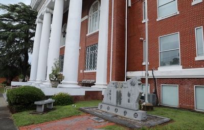
On Adams Street north of East Main Street, on the right when traveling north.
In memory of the men who gave their lives in the service of their country
World War I
James E. Jethro • Grover C. Oliver • Bismark Wheelock
World War II
Ferrell Ambrose • Hubert W. Ange • Aubrey Asby • Clarence E. Ayers, Jr. . . . — — Map (db m226531) WM
On West Water Street at Monroe Street, on the right when traveling west on West Water Street.
In its edition of August 27, 1851, the Plymouth Villager made a backhanded confirmation of the presence of abolitionists in Washington County, North Carolina. "A coat of tar and feathers is in waiting for the gentleman who will come about . . . — — Map (db m276306) HM
On West Water Street at Monroe Street, on the right when traveling west on West Water Street.
Plymouth Landing
In the late 17th century, two traders built a trading post on the Roanoke River in what is now downtown Plymouth. By 1738, the site was called Brickhouse Plantation on maps. A shipyard was built there in 1771, and a settlement . . . — — Map (db m276297) HM
First governor of Kentucky
1792-1796
Fifth governor of Kentucky
1812-1816
One of Shelby’s first acts as Governor was to call for and help design the Great Seal of the Commonwealth of Kentucky. The figures of a pioneer and statesman in this . . . — — Map (db m121734) HM
Near Emmanuel Drive north of Cedar Grove Road, on the left when traveling north.
Washington County, then part of North Carolina, was established in 1777 during the height of the American Revolution, replacing the earlier Washington District (1776) and Watauga Association (1772). On February 23, 1778, the first court of the new . . . — — Map (db m184139) HM
On Bristol Highway (Tennessee Route 126) west of Anderson Road, on the right when traveling west.
Sullivan County was established by the North Carolina Assembly’s October 1779 session; its north of the Holston River section formerly in Washington County, Virginia; and its south of the river section formerly in Washington County, North Carolina. . . . — — Map (db m69711) HM
Now a mere fraction of its original size, Washington County was Tennessee’s first county and the first political division in the United States named for George Washington. Jonesborough, a planned town from its inception, claims to be the state’s . . . — — Map (db m201315) HM
On Tennessee Route 160, on the right when traveling north.
The homesite and grave of Revolutionary War officer, Colonel Robert McFarland, is located two miles north at Springvale. Born in 1759 in Orange County, North Carolina, he served in the Virginia Militia from 1776 to 1781. In 1783, McFarland moved . . . — — Map (db m80442) HM
On West Jackson Boulevard (U.S. 11E) 0.1 miles east of West College Street ( Route 81), on the right when traveling east. Reported missing.
Formally established in 1779, by the General Assembly of North Carolina, as county seat of Washington County, first county west of the mountains. In 1784, the State of Franklin was organized here, with Jonesboro as its first capital. — — Map (db m234534) HM
On Waters Lane at Old Baylor College Road, on the left when traveling west on Waters Lane.
A native of North Carolina, John Prince Coles brought his family to Texas in 1821 with Stephen F. Austin's "Old Three Hundred" colonists. Arriving in present Washington County on New Year's Day in 1822, Coles received a Mexican land grant . . . — — Map (db m156743) HM
On West Water Street at Monroe Street, on the right when traveling west on West Water Street.
Dedicated to the bravery of the enslaved people who came to the Plymouth waterfront seeking their freedom; and to their allies, enslaved and free, who, at great risk, helped the freedom seekers to find their way to a better life.
Plymouth . . . — — Map (db m276303) HM
On State Highway 36 south of Jungle Lane, on the right when traveling north.
A native of North Carolina, Robert Starke Armistead moved with his family to Alabama in 1818. He married Ann Sylvesta Carney in 1826 and they came to Texas in 1835. Armistead served in the Republic of Texas army in 1836 and with forces defending San . . . — — Map (db m125651) HM
On outh Potomac Street (Maryland Route 65), on the right when traveling north.
Immediately after the Civil War, Union casualties in the Frederick-Washington County areas were re-interred at a new National Cemetery at Sharpsburg. Yet no provisions were made to provide decent burial for thousands of hastily-buried . . . — — Map (db m153412) HM
John Carter
- 1781
Chairman of Watauga Association and of the five commissioners who established that first written compact for civil government by American-born freemen. Chairman of Committee of Safety. In Revolution, colonel of militia . . . — — Map (db m157908) HM
On Effingham Hwy (State Highway 17) at Oliver Highway (State Highway 24), on the right when traveling south on Effingham Hwy.
On Nov. 28, 1864, Maj. Gen. H.C. Wayne, Adj. Gen. of Georgia, with a small force (CS) composed of the Corps of Cadets, Georgia Military Institute, Warthen`s Washington County militia company and Pruden`s battery, fell back from Millen and entrenched . . . — — Map (db m13093) HM
On State Highway 91 1.6 miles south of Jeb Stuart Highway (U.S. 58), on the right when traveling south.
Washington County, Virginia Formed in 1776 from Fincastle, and named for George Washington. This county was the first locality named for him. General William Campbell, hero of King's Mountain, lived in this county. Emory and Henry College is in . . . — — Map (db m228773) HM
On Milligan Highway at Cedar Grove Road, on the left when traveling east on Milligan Highway.
On Feb. 23, 1778, 0.6 mile NE at the house of Col. Charles Robertson, Trustee, on the “east (Catbird) branch of Sinking Creek” was held the First Court of the newly formed County of Washington, North Carolina, with John Carter, Chairman; John . . . — — Map (db m83061) HM
On State Highway 14 0.5 miles north of County Highway 662, on the right when traveling north.
The Brown Family Cemetery traces its origin to the settlement of North Carolina native Ervin Brown (1801 1875) and his wife Matilda (1807-1871) in Washington County, Texas. In 1846, Ervin and Matilda moved their family to a 1600 - acre farm, in . . . — — Map (db m159060) HM
On Virginia Creeper National Recreation Trail west of Mountain View Drive, on the left when traveling west.
The Virginia Carolina Railway which is now the Virginia Creeper Trail was originally built to haul timber cut from what is now the Mount Rogers National Recreation Area. It is estimated that between 1907 and 1930 approximately 15 million board feet . . . — — Map (db m211093) HM
On North Beaver Dam Avenue (U.S. 58) 0.2 miles north of West Laurel Avenue (U.S. 58), on the right when traveling north.
In front of you are the remains of one of the six water tanks which existed along the old Abingdon Branch of the Norfolk and Western line, or Virginia Creeper as it was locally known. The locations were Abingdon, Damascus, and Creek junction in . . . — — Map (db m209499) HM
On South Broad Street, on the right when traveling south.
Organized in March 1862 under the leadership of Capt. William Badham Jr., Lt. John M. Jones, and Lt. Nelson McClees, the Edenton Bell Battery was composed of men primarily from Chowan, Tyrrell, and Washington Counties. Lacking adequate artillery, . . . — — Map (db m34835) HM
Near South Broad Street south of West King Street, on the right when traveling south.
This location in the back garden may well be the site of the original kitchen as outlined above in the Sanborn Five Insurance Map of 1883. An excellent example of a surviving 18th century kitchen is found at Somerset Place, across Albemarle Sound . . . — — Map (db m226115) HM
On Muster Place at Colonial Road SW on Muster Place.
Determined men on horseback filled this muster ground on September 24, 1780. Their goal: hunt down British Major Patrick Ferguson and his 1,000 loyalist soldiers. Called to action by American Colonel William Campbell, 400 men from the surrounding . . . — — Map (db m210131) HM
On South Riverside Drive north of Hattie Avenue, on the right when traveling north.
The first republic established west of the Appalachians was the Watauga Association, which was formed in May 1772 under the shade of an old Sycamore tree, located on the banks of the Doe River. The famed tree, was cut down in 1987, after efforts to . . . — — Map (db m306554) HM
On Boone Street 0.1 miles north of East Main Street (Old Tennessee Route 34), on the left when traveling north.
Buried here July 4, 1979 on the two-hundredth anniversary of Jonesboro, Tennessee 1779 — 1979 to be opened on July 4, 2079 ——— Town of Jonesboro Mayor Jimmy Neil Smith Aldermen Tobie Bledsoe • Sam . . . — — Map (db m267469) HM
On Georgia Route 15 S at Montgomery Road, on the right when traveling south on Georgia Route 15 S.
Colby Smith, a Revolutionary War soldier who was prominent in America’s War of Independence settled in the 89th District in 1798 and was granted property by the Governor of Georgia in Honor of his service to America. He, his children, and his . . . — — Map (db m21300) HM
On North Carolina Avenue just north of West Cherokee Street (State Route 11), on the left when traveling north.
Prelude to the Battle of Kings Mountain In the vicinity before you, a Patriot militia numbering 1,400 continued their two-week march in search of British Major Patrick Ferguson and his Loyalist army during the Revolutionary War. The . . . — — Map (db m196946) HM
On South Roan Street east of Highridge Bonita Drive, on the right when traveling east.
The failed State of Franklin was formed in August of 1784 and comprised the area of then western North Carolina, present-day Northeast Tennessee. John Sevier was elected governor of Franklin while Colonel John Tipton became a leading loyalist to . . . — — Map (db m295180) HM
On South Roan Street south of Bonita Drive, on the right when traveling east.
Shortly after the Revolutionary War, Colonel John Tipton moved to then Washington County, North Carolina. He purchased over two thousand acres of land in 1784 in what is now Johnson City and nearby Elizabethton, Tennessee. He constructed a simple . . . — — Map (db m295173) HM
The following three patriots are interred in Section OP. Lots 26. 106, and 214.
ELIJAH SMITH
Born on August 12, 1755, near Trenton, Hunterdon County. New Jersey. Died March 11, 1836 at age 80 in Illinois. Enlisted the first time in 1776 . . . — — Map (db m287414) HM WM
Near Magnolia Road (County Route 1118) 0.3 miles south of Lake Shore Road, on the left when traveling south.
James Johnston Pettigrew was born here at Bonarva on July 4, 1828. His father, Ebenezer Pettigrew, operated several large plantations in Tyrell and Washington Counties. Johnston Pettigrew, as he was called, graduated in 1847 from the University of . . . — — Map (db m76822) HM
On Greenlee Ford Road 0.3 miles north of Carbon City Road (U.S. 70), on the right when traveling north.
During the America n Revolution, at this ford of the Catawba River, around 1390 men from Western North Carolina and Southwestern Virginia crossed here on their way to the Battle Of Kings Mountain. The men who crossed the river here were all . . . — — Map (db m285957) HM WM
On North Churton Street at West Union Street, on the right when traveling south on North Churton Street.
The Reverend Robert Burwell, his wife Anna, and their two children moved from Virginia to Hillsborough in 1835. The Presbyterians, who hired him as their minister, provided the family with a house which was built around 1821 on the corner of Union . . . — — Map (db m232399) HM
On 6th Avenue North, on the left when traveling north.
Walkway of the Counties
Welcome to the Walkway of Counties, a path that commemorates the 95 governmental divisions of Tennessee and the fascinating land and plants found in the state.
The walkway is divided at points representing the . . . — — Map (db m206494) HM
Near Hartsville Pike (Tennessee Route 25) 0.1 miles west of Rock Springs Road.
Col. Anthony Bledsoe
Born in Culpepper Co. VA, 1733
Killed by Indians about 200 yards west from this spot, July 20, 1788.
and his wife, Mary Ramsey Bledsoe
Born in Augusta Co. VA, 1734
Died in Sumner Co. Tenn, 1808
Col. Issac . . . — — Map (db m180309) HM
On East Telegraph Street at North Main Street, on the right when traveling west on East Telegraph Street.
Present city officials and citizens of Washington City desired to pay tribute to early prominent pioneers who first settled here in 1857. These pioneers sacrificed their all while improving conditions in this harsh, dry, hot inhospitable, . . . — — Map (db m59315) HM
On U.S. 231 0.2 miles north of State Route 36, on the right when traveling north.
Abundant water and fertile land in this area south of the Tennessee River attracted pioneer settlement in the early 1800s. The community established here by three Virginia-born brothers, Hopkins, John, and Theophilus Lacy, took on their name and . . . — — Map (db m27611) HM
On Lakeview Parkway near Shoosmith Road, on the left when traveling north.
During the first 18 months of the Civil War, President Abraham Lincoln chose not to act upon recommendations of Frederick Douglass, and others, to enlist Black men in the Union Army in the fight against the Confederacy. After the much-needed Union . . . — — Map (db m314862) HM
On Green Spring Road at Gibson Street SE, on the left when traveling south on Green Spring Road.
The Abingdon Branch
“The Virginia Creeper”
Norfolk & Western Railway’s Abingdon Branch began in 1887 as the Abingdon Coal and Iron Railroad (AC&IRR). The Virginia-Carolina Railroad (VCRR) bought the AC&IRR in 1900, and extended rail . . . — — Map (db m67291) HM
A native of Scotland, Alexander Beaton came to the United States in 1843. He migrated to Texas in 1848 after serving in the U.S. Army during the Mexican War. In 1850 he settled in Corsicana and began the practice of law. He was chairman of the . . . — — Map (db m60493) HM
Thin black lines indicate changes in relevance. Between each pair of lines entries are ordered geographically but all have the same relevance.
* Inflectional forms of words are their plurals, singulars, and possessives as well as gramatical tenses and similar variations.