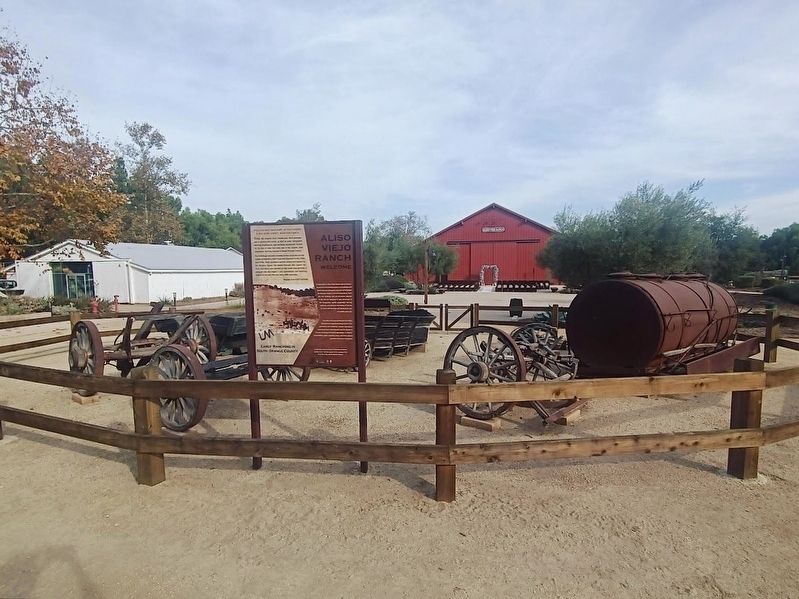
This site was once part of the former 22,000-acre Lewis F. Moulton Ranch
Today, the original barn, bunkhouse, shed garages, and a century-old cactus, as well as some antiquated farming implements and ranching equipment, remain on the . . . — — Map (db m263043) HM
Near Plaza De La Paz west of La Paz Road. Reported unreadable.
This skull of Mixocetus baleen whale was discovered during grading of this plaza. It is the second example of the species known to science. The first was found in Los Angles in 1931.
Mixocetus was one of the largest marine animals to inhabit . . . — — Map (db m188542) HM
On South Knott Avenue, on the right when traveling north.
For more than half a century, the Pacific Electric Railway served Southern California. The system was established by Henry Huntington in 1895 and linked Los Angeles, Orange, Riverside, and San Bernardino counties with over 1,000 miles of service and . . . — — Map (db m101471) HM
On Knott Avenue, on the right when traveling south.
For more than half a century, the Pacific Electric Railway served Southern California. The system was established by Henry Huntington in 1895 and linked Los Angeles, Orange, Riverside, and San Bernardino counties with over 1,000 miles of service and . . . — — Map (db m101472) HM
Near West Street north of Pearl Street, on the right when traveling north.
Inspired by John Frohling's vision of a viticulture utopia, the Los Angeles Vineyard Society was formed in 1857. Convinced that wine was the way to wealth, the Society joined the scramble for land and sent surveyor George Hansen on a quest that . . . — — Map (db m189671) HM
In 1866, German Colonists established the Anaheim Cemetery as the first public cemetery in Orange County. Many of the early leaders of Anaheim and Orange County are interred here. The Community Mausoleum was built in 1914 as the first mausoleum on . . . — — Map (db m58908) HM
In 1960, a group of 61 Anaheim business people calling themselves the Anaheim
Visitor and Convention Bureau organized to see what they could do to make the
city a year-round tourist destination. Their goal was to better capitalize on the
huge . . . — — Map (db m234345) HM
On West Street north of Pearl Street, on the right when traveling north.
The houses of Founders' Park illustrates how 19th century Anaheim architecture evolved. The modest Mother Colony House, now the oldest wood frame structure in Orange County, represents the first years of the Anaheim Colony. It reflects the hard . . . — — Map (db m189669) HM
On La Palma Avenue 0.2 miles east of Kraemer Boulevard, on the left when traveling east.
Pioneering innovations in electronics, guidance, navigation and control that charted new frontiers on Earth and beyond.
This monument is dedicated to every Autonetics employee and retiree whose legacy of excellence continues today as part of . . . — — Map (db m195480) HM
The Cactus Garden was conceived by Rudolph "Rudy" Boysen, Superintendent
of Anaheim City Parks from 1928 to 1949. Mr. Boysen, a noted botanist and
creator of the "boysenberry," placed a variety of cactus in this garden, including
several rare . . . — — Map (db m193789) HM
At this theater on the night of December 21, 1937, Walt Disney introduced to the world the first full-color, feature-length animated motion picture, Snow White and the Seven Dwarfs. The rest, as they say, is history! — — Map (db m189320) HM
Near Disneyland Drive just south of Magic Way, on the right when traveling south.
Cascade Falls and Ol’ Unfaithful were once prominent features in the classic Frontierland attraction Mine Train Thru Nature's Wonderland, which made its debut at
Disneyland in 1960. Taking its cue from the True Life
Adventures series nature films, . . . — — Map (db m165217) HM
Near East Sycamore Street at East Sycamore Street, on the right when traveling east.
This grove of dawn redwood trees was planted by the Orange County Cemetery District as a memorial to the People of Chinese Heritage interred in the Anaheim Cemetery. This species of tree was thought to be extinct until they were rediscovered growing . . . — — Map (db m197717)
Disney engineers designed this monorail system, based on the system developed by Axel L. Wenner-Gren (ALWEG). Built at the Walt Disney Studios, the system is intended to apply to urban transit. Opened in 1959, it has been in daily passenger . . . — — Map (db m155278) HM
On Sycamore Street, on the right when traveling east.
This statue is the oldest public works of art project of its type in Orange County. Sponsored by the State Emergency Relief Administration, the Anaheim Rotary Club and the City of Anaheim, it was originally dedicated on September 15, 1935. . . . — — Map (db m51967) HM
Near Sycamore Street near Hawthorn Street, on the right when traveling east.
The historic Anaheim Cemetery was founded in 1866 by German Colonists who organized the Anaheim Cemetery Association and purchased the original five acre site from Phillip Sichel. In 1893 the final parcel of land was purchased from Capt. Irwin Barr. . . . — — Map (db m199513) HM
Near Katella Avenue west of Interstate 5, on the right when traveling west.
Kate and Ella, the daughters of the Rea family, were early settlers of Anaheim. The family named their ranch "Katella Ranch" after their daughters. The original Anaheim wagon track was later named after them and is now Katella Ave.
Artist: . . . — — Map (db m123516) HM
Said to be from a pirate ship commanded by Jean Lafitte in the battle of New Orleans, January 8, 1815.
It is also said that Lafitte's privateering steps left a wake of blood from the mainland to Barataria Bay.
But don't believe everything you . . . — — Map (db m189871) HM
On Broadway at Loara Street, on the right when traveling west on Broadway.
In 1869, near this location, Mr. Benjamin F. Kellogg helped establish the pioneer farming community of Fairview. In 1870 Mr. Kellogg donated land for the first Fairview school, built at today's Ball Road and Euclid Avenue. By 1888 the school, one of . . . — — Map (db m59762) HM
This courtyard was dedicated September 17th 1999 in loving memory of Michelle Carew. Her spirited battle against leukemia raised awareness of the National Marrow Donor Program throughout this country. In the process, her legacy has saved countless . . . — — Map (db m311) HM
On West Street near Sycamore Street, on the right when traveling north.
This house was built in 1857 by Mr. Geo. Hansen the promoter of that little colony of Germans who founded what is now the City of Anaheim, and originally stood on N. Los Angeles St. between Chartres & Cypress Sts.
The building was a gift . . . — — Map (db m241957) HM
On West Street near Sycamore Street, on the right when traveling north.
The first house built in Anaheim (1857). It was here that Henryk Sienkiewicz resided with Madame Helena Modjeska in 1876. He is one of the most popular Polish writers and was awarded the Nobel Prize in Literature in 1905 for his outstanding merits . . . — — Map (db m281322) HM
On West Street near Sycamore Street, on the right when traveling north.
First house built in Anaheim, 1857, by George Hanson, founder "The Mother Colony", group selecting name given settlement. This German group left San Francisco to form grape growing colony. Southern California Vineyards became largest in California . . . — — Map (db m50119) HM
On Anaheim Boulevard 0.3 miles south of Lincoln Avenue, on the right when traveling south.
Anaheim's first building constructed exclusively for library use was erected in 1908 with a grant of $10,000 from philanthropist Andrew Carnegie. The site was purchased with funds raised by popular subscription. This building was designed by Los . . . — — Map (db m314294) HM
On West Street north of Pearl Street, on the right when traveling north.
Writer George Wharton James concluded that Southern California's climate invited residents into the open. Throughout its entire history, Anaheim has proven James correct. In period photographs, hand pumps shared backyards with swings while chicken . . . — — Map (db m189670) HM
On Santa Ana Canyon Road at Fairmont Boulevard, on the right when traveling east on Santa Ana Canyon Road.
Ramon Peralta built this adobe dwelling in 1871. His grandfather, Juan Pablo Peralta, was co-grantee with Jose Antonio Yorba of the only Spanish land grant in Orange County, the Rancho Santiago de Santa Ana, upon which the old Peralta settlement was . . . — — Map (db m50017) HM
This section weighs five tons and measures 7½ feet in diameter. The original tree, estimated to have been 200 feet tall, was part of a sub-tropical forest 55 to 70 million years ago in what is now Colorado. Scientists believe it to be of the Redwood . . . — — Map (db m155279) HM
The original townsite of Anaheim was surrounded by a living fence of willow trees to keep out the livestock which roamed freely on the open range. This is the site of the gate that was opened to permit travel to and from San Pedro and Los Angeles. — — Map (db m49990) HM
On South Street 0.1 miles west of Anaheim Boulevard, on the right when traveling west.
The walls of this House of God are hallowed by the prayers of countless worshippers. For nearly a century the mellow tones of its bell have called the faithful to prayer, announced weddings with joy, and tolled in grief for those who have passed . . . — — Map (db m49995) HM
This sculpture, which was created by artists Michael Davis, Ann Preston and Richard Turner, explores the nature of perception. The reflected images cast upon the central column and the ink blot forms, which appear on the ground surrounding the . . . — — Map (db m309537)
On Clementine Street just north of Wilhelmina Street, on the right when traveling north.
Built 1922,
712 North Clementine Street,
has been designated as historically
significant to the
Anaheim Colony Historic District
under the City of Anaheim's
Mills Act program. — — Map (db m211428) HM
According to legend, Lester Pelton got his idea for a more powerful waterwheel from seeing a cow stick its nose into a stream of water. Patented in 1878, the divided metal cups of Pelton's wheel worked much the same way as the cleft between the . . . — — Map (db m155281) HM
How the Dolbeer Donkey steam engine got its name is one of the real mysteries of the West. Some folks say it was called a "donkey" because loggers thought it was too puny to merit a horsepower rating. Invented by John Dolbeer, this portable steam . . . — — Map (db m155280) HM
On Ball Road east of Lewis Street, on the right when traveling east.
This nine foot band saw is among the largest log saws ever used in the sawmill industry. It weighs over 38,000 pounds and has a blade that stre[t]ches over fifty-six feet in length. This saw was used to cut Douglass Fir logs up to ten feet in . . . — — Map (db m199505) HM
On Santa Ana Canyon Road at Imperial Highway, on the right when traveling west on Santa Ana Canyon Road.
This boulder marks the site of one of the first public schools in this county.
Built 1867.
First teacher - Jennie Swift.
William M. McFadden taught here 1869 to 1879. — — Map (db m189683) HM
Near West Street at Pearl Street, on the right when traveling north.
Wind and Water Anaheim's early settlers put wind to work. Windmills rose above homestead rooflines poised to catch ocean breezes, shifting with the air currents, spinning gears effortlessly, and pumping water to the arid surface. Often . . . — — Map (db m189673) HM
On West Broadway east of South Clementine Street, on the right when traveling east.
"The Angell House"
Built 1912. 214 West Broadway has been designated as historically significant to the Anaheim Colony Historic District under the city of Anaheim's Mills Act Program. — — Map (db m254644) HM
On Harbor Boulevard, on the right when traveling south.
"The Beck House"
Built 1930
319 N Harbor Boulevard
has been designated as historically significant to the Anaheim Colony Historic District under the city of Anaheim's Mills Act Program. — — Map (db m254641) HM
Near Imperial Highway north of Nohl Ranch Road, on the right when traveling north.
Sometime after 1814, Juan Pablo Peralta I, co-grantee
of the Rancho Santiago de Santa Ana, built his adobe
home east of here. His children, and their children in
turn, built theirs near his. In 1871, Peralta was
comprised of a small cluster of . . . — — Map (db m244172) HM
Transplanted from one of Anaheim's parks in the
late 1960's to its present location, the exact age
of this Ficus macrophylla, (commonly known as the Moreton Bay Fig), tree is unknown. It is estimated to have first been planted as early as . . . — — Map (db m257484) HM
The 13 Flags displayed along the top of the log stockade are like those carried by American troops during the REVOLUTIONARY WAR. These standards represent the home countries, colonies, divisions and regiments of the soldiers.
One of the first . . . — — Map (db m298503) HM
Near Gene Autry Way east of State College Boulevard.
Founder of California Angels 1961. His uniform number 26 was retired in 1982 by the players. Singing cowboy · Actor · Composer · Airforce pilot · Entrepreneur · Baseball fan · Philanthropist · 33rd Degree Mason · Best friend
Statue . . . — — Map (db m309280) HM
On Katella Ave., on the right when traveling east.
The Santa Ana River stretches over a distance of 110 miles before reaching the Pacific Ocean at Huntington Beach. It is the largest river entirely within Southern California.
From Dollar Lake and Dry Lake on to Big Bear Lake in the San . . . — — Map (db m224296) HM
A string of forts such as this one linked the American frontiers together. Primarily erected as outposts of defense and protection for pioneer settlers, they were also used for community gatherings and trading posts.
The blockhouses, with . . . — — Map (db m298505) HM
"Redwoods are...ambassadors from another time."
-John Steinbeck
Travels with Charley (c. John Steinbeck 1962)
Every tree has a tale to tell, and the tree's rings tell us its story. A California redwood grows by . . . — — Map (db m267809) HM
Cannon have long been used to memorialize military campaigns. Purely commemorative, the two cannon flanking town square are permanently sealed, never having been fired in battle. Dating from the 19th century, these once belonged to the French . . . — — Map (db m290002) HM
On West Broadway, on the right when traveling east.
"The Ingram Apartments"
Built 1921
218-220½ West Broadway has been designated as historically significant to the Anaheim Colony Historic District under the city of Anaheim's Mills Act Program — — Map (db m254642) HM
On South Atchison Street, on the right when traveling north.
The Kroeger-Melrose District,
Listed in The National Register of Historic Places 1985.
Administered by the National Park Service - United States Department of the Interior — — Map (db m266746) HM
Many of the kids designed water features for their play areas like the ones you
see here. This idea was incorporated into the final play area design through
the use of the dry creek running through the site. This dry creek acts as a way
to catch . . . — — Map (db m230824) HM
Kids from the surrounding Anaheim community put their imaginations together to come up with designs that they would want to play on in their park. This Minecraft ™ zip line that started out as a fun idea from a group of kids is now brought to life . . . — — Map (db m230826) HM
In 2012, Mojang, the creators of Minecraft, partnered with the United Nations Human Settlements Programme (UN-Habitat) to launch an initiative called Block by Block, which uses Minecraft to help communities reimagine public spaces.
At the . . . — — Map (db m230829) HM
On E Bay Ave at Main Street, on the left when traveling east on E Bay Ave.
The Pavilion, built in 1905, and this building were prominent features of Balboa Village in 1918. Henry Huntington's Red Car Trolleys ran regular schedules between the Balboa Terminus and points north to Los Angeles.
Today the Pavilion . . . — — Map (db m112985) HM
On Brea Boulevard at Elm Street, on the right when traveling south on Brea Boulevard.
Since 1920, the American Legion has had an active presence in Brea. Post #181 dedicated a structure on this site on November 8, 1924 followed by a transformation to this Mission Style building in 1931.
It housed the Brea Women's Club during . . . — — Map (db m199553) HM
Near Brea Boulevard south of Date Street, on the right when traveling south.
Built in 1929, the Brea Plunge is known as the oldest continually operating municipal pool in Orange County. Generations of Breans have celebrated summer and learned to swim here with only a few interruptions. The Plunge closed for the summer of . . . — — Map (db m199733) HM
Near Elm Street at Brea Boulevard, on the right when traveling west.
Opened in 1930
Soon after Brea was incorporated in 1917, city leaders saw a need for a
public park that could be enjoyed by all the city's inhabitants. Planning began
and in 1930 City Hall Park opened and quickly became the town's . . . — — Map (db m244171) HM
Near Brea Boulevard south of Date Street, on the right when traveling south.
Many a child whiled away the hours at this fishing pond in City Hall Park during the 1940's. The pond also attracted a large population of bull frogs that became so noisy they disturbed the neighbors every night to the extent the pond was finally . . . — — Map (db m199731) HM
On Brea Boulevard at Date Street, on the right when traveling south on Brea Boulevard.
The five-acre site for old City Hall was purchased in 1928 for $30,392.82. This Spanish Mediterranean-style building was dedicated in 1929 and housed Brea City Council chamber and offices, police, jail, fire, library, Municipal Court judge, Chamber . . . — — Map (db m175849) HM
On Carbon Canyon Road at Santa Fe Road, on the right when traveling east on Carbon Canyon Road.
The course of oil production was changed in 1899 when the Olinda area became the first site in California to use the technique of drilling with the hole full of water. Having been developed as a source of fuel oil for for the Santa Fe Railroad, . . . — — Map (db m50337) HM
Near Sante Fe Road north of Carbon Canyon Road, on the left when traveling east.
While the oilfield here remains active, the earlier community is gone. Dwindling oil reserves and technology reduced the number of employees, flood water from these canyons made life hazardous, and suburban development become increasingly . . . — — Map (db m189675) HM
On this site, Edward L. Doheny drilled the first oil well in the Olinda field in 1897. Olinda #1, drilled to 806 feet, pumped about 50 barrels per day (bpd). By 1898, ten wells were drilled, some producing up to 100 bpd. In 1899, the Santa Fe . . . — — Map (db m238742) HM
Near Brea Boulevard south of Date Street, on the right when traveling south.
Born in Parsons, Kansas, twenty-one year old Ralph Barnes came to California in 1923 with this family and settled in Orange County. After a brief stint in the City of Orange, he secured a position at the First National Bank in Brea, then a small oil . . . — — Map (db m199735) HM
Near Brea Boulevard south of Date Street, on the right when traveling south.
As part of a four-city Orange County campaign tour, vice presidential candidate Richard Nixon made a 10-minute speech in City Hall Park on October 20, 1952, in front of 1,600 excited supporters. Brea's "country doctor” Glenn Curtis introduced . . . — — Map (db m199730) HM
On Brea Boulevard 0.3 miles north of Imperial Highway, on the right when traveling north.
Approximately 50 feet south of this spot in February 1928, the first full-cantilever, low-wing monoplane was built in the United States. Named the "Humming Bird", this tiny plane was designed and built by young Austrian immigrant Fred Thaheld and . . . — — Map (db m199559) HM
On Holder Street, on the right when traveling north.
For more than half a century, the Pacific Electric Railway served Southern California. The system was established by Henry Huntington in 1895 and linked Los Angeles, Orange, Riverside, and San Bernardino counties with over 1,000 miles of service and . . . — — Map (db m101470) HM
Near Beach Boulevard, on the left when traveling north.
Tombstone, Arizona was a rich and riotous mining camp in December 1881 when former opera house manager Billy Hutchinson opened the doors of The Bird Cage Theatre from the onset it was patronized twenty-four hours a day by the town’s miners, . . . — — Map (db m192480) HM
Near Beach Boulevard, on the left when traveling north.
Early transportation methods consisted primarily of horse, mule, and ox power. These animals all had to be shod to protect their hooves. Consequently, the Blacksmith was an important figure in the Old West. He not only made the shoes for the . . . — — Map (db m192483) HM
On Beach Boulevard at 11th Street, on the right when traveling south on Beach Boulevard.
Since its establshment in a newly created Orange County (1889), the Buena Park Woman's Club has influenced the civic life of its community. The club helped establish a volunteer fire department in 1915, a library district in 1919, and the town's . . . — — Map (db m50036) HM
On Grand Avenue, on the right when traveling south.
Founded as a 10-acre farm in 1920 by Cordella and Walter Knott, developer of the boysenberry. From berry fields came a tea room, berry market, nursery and one of the Nation's oldest themed amusement partks now on 150 acres with authentic replicas of . . . — — Map (db m50002) HM
Near Beach Boulevard, on the right when traveling west.
Knott’s classic wooden carousel was carved at the turn–of-the–century in the Philadelphia, Pennsylvania shop of Gustav A. Dentzel. The young Dentzel had come to America in 1864 after learning the carousel carving trade from his father . . . — — Map (db m103384) HM
Near Beach Boulevard, on the left when traveling north.
This old wood-burning engine was used in early-day borax mining on the desert in Death Valley and was brought here in 1941. It was a distinct improvement over the 20-mule team that used to haul borax from the mines, but was still hot, miserable work . . . — — Map (db m192482) HM
This was the first school in the Rivera District, constructed in 1868, and previously located on Shugg Lane, now Slauson Avenue — — Map (db m103382) HM
Near Beach Boulevard, on the right when traveling west.
Typical of one room schoolhouse of the 1800's is this one from Beloit, Kansas. Built in 1879, it housed 8 classes at a time from the first through the eighth grades. Schools rarely had more than two rooms in those days, due not only to the limited . . . — — Map (db m103383) HM
On Beach Boulevard south of Santa Ana Freeway, on the right when traveling north.
Established 1889 as the Pacific Condensed Milk, Coffee and Canning Co. by J.M. Pitblado. First evaporated milk cannery in California and the first industry in Buena Park. The Bixby family owned the factory from 1896 until it closed in 1907. Site was . . . — — Map (db m49986) HM
On Pacific Coast Highway (U.S. 1) at Marguerite Avenue, on the right when traveling south on Pacific Coast Highway.
In 1906 guidepost bells were placed along the El Camino Real to guide early travelers and to preserve this historic route which linked California's missions beginning in 1769. — — Map (db m204334) HM
Near San Joaquin Hills Road south of MacArthur Boulevard, on the right when traveling south.
The Original Disneyland Bandstand is where Mickey Mouse led his
16-piece band the day Disneyland opened on July 17, 1955.
In the mid-1970s, Roger's Gardens acquired the Disneyland Bandstand and moved
it to its present location, where it . . . — — Map (db m207155) HM
On Adams Avenue at Mesa Verde Drive West, on the right when traveling west on Adams Avenue.
This home of early Spanish Californians, erected in the 1820's, once served as an "estancia" or station for mission herdsmen. It was dedicated in 1963 for public use by the Segerstrom Family and restored by the City of Costa Mesa. It is jointly . . . — — Map (db m50306) HM
The Air Base was one of the largest of its kind in the nation. It was activated in February of 1942. Pilots trained here for Europe and the Pacific during World War II. — — Map (db m58598) HM
1884 entries matched your criteria. The first 100 are listed above. Next 100 ⊳