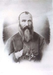
On Benvoulin Road 0.1 kilometers north of Casorso Road, on the right when traveling north. Reported missing.
Father Pandosy, an Oblate priest, ministered to natives and white in widely separated parts of British Columbia for over 30 years, until his death in 1891.
His mission, with its church, school and farms established in 1859-60 on this site, formed . . . — — Map (db m187909) HM
On Okanagan Highway (Provincial Highway 97) 0.2 kilometers south of Hardy Street, on the left when traveling south.
Directly across Lake Okanagan, on August 16, 2003, lightning struck a tree at Squally Point. The ensuing blaze consumed over 25,000 hectares as it spread to Kelowna, Myra Canyon, and Naramata. More than 33,000 people were evacuated and 238 homes . . . — — Map (db m187982) HM
Near Trans-Canada Highway (Provincial Highway 1) 0.8 kilometers north of Lybarger Road, on the right when traveling north.
[English] While exploring these mountains in the summer of 1865, Walter Moberly, assistant surveyor-general of British Columbia, noted the flight of eagles through a break in the Gold Range (Monashees), thereby discovering Eagle Pass. After . . . — — Map (db m198549) HM
Near Trans-Canada Highway (Provincial Highway 1) 0.8 kilometers north of Lybarger Road, on the right when traveling north.
A nebulous dream was a reality: an iron ribbon crossed Canada from sea to sea. Often following the footsteps of early explorers, nearly 3000 miles of steel rail pushed across vast prairies, cleft lofty mountain passes, twisted through canyons, and . . . — — Map (db m187955) HM
Near Trans Canada Highway (Route 1) west of Whispering Wood Lane.
[English]
Baldwin #7717 Steam Locomotive
This Baldwin 2-6-0 mogul steam engine – builders #7717 – road #6 – 36" gauge locomotive, was built for the North Western Coal & Navigation Co. in 1885. It was originally used . . . — — Map (db m44339) HM
Canadian Pacific Railway Log Houses
circa 1928
These log homes were built for Canadian Pacific Railways officials. A closer look at the houses reveals a unique form of saddle-notch construction. Wood for these homes . . . — — Map (db m251343) HM
On Transcanada Highway (National Route 1), on the right when traveling west.
First recorded in the report of the Palliser expedition of 1857-60, this pass takes its name from an incident in which Dr. James Hector, surgeon in the expedition, was kicked by his horse while exploring in this vicinity. The pass was . . . — — Map (db m74545) HM
Near Trans-Canada Highway (Provincial Highway 1) at Field Access Road.
[English] Take a look across the river. A century ago, an elegant hotel dominated this view. Now just a memory, Mount Stephen House was the first in a series of “Grand Hotels” built by the Canadian Pacific Railway. The CPR . . . — — Map (db m203580) HM
Near Trans-Canada Highway (Provincial Highway 1) at Field Access Road.
[English] In 1901, Mount Stephen Reserve was enlarged and became Yoho Park Reserve. The following year, Mount Stephen House was also expanded and now featured a rotunda, a huge dining room, a theatre and 60 rooms. Word got out . . . — — Map (db m203581) HM
Near Trans-Canada Highway (Provincial Highway 1) at Field Access Road.
[English] It was not my intention to have passed any great time at Field, yet I was detained there by the force of its attraction… the views from Field are fine and the excursions that can be made in the neighbourhood are . . . — — Map (db m203582) HM
On 1st Avenue at East First Street, on the left when traveling south on 1st Avenue.
St Joseph Roman Catholic Church
For over 100 years, St. Joseph's has served the community of Field. Mass is still held here during the summer, and the original church bell tolls on special occasions. Prior to the 1950's, the . . . — — Map (db m303273) HM
Covered bridges are very popular as historical landmarks, tourist attractions, and romantic links to a by-gone era. There are literally dozens of organizations dedicated to their preservation, education, and promotion. Yet despite their unique . . . — — Map (db m313492) HM
Near 11 Avenue South at 14 Street South, on the right when traveling north.
Victory gardens, also called War Gardens or Food Gardens for Defense, were vegetable, fruit, and herb gardens planted at private residences and public parks in the United States, United Kingdom, Canada, Australia and Germany during World War I and . . . — — Map (db m313633) HM
Near Golden View Road 0.2 kilometers south of Lafontaine Road, on the right when traveling south.
The first Sikhs arrived in Golden in 1902 to work in the mill of the Columbia River Lumber Company. Their Gurdwara (temple), one of the earliest in BC, became a focus of cultural identity and religious ceremony for the Sikh community.
Their . . . — — Map (db m188006) HM
Near 10th Avenue South (Provincial Highway 95) at 11 Avenue South, on the right when traveling north.
With the completion of the railway in 1885 the Canadian Pacific Railway recognised that many travellers through Golden would want to stay and discover this incredible area for themselves. To this end, the CPR hired professional Swiss mountain . . . — — Map (db m313481) HM
Near 11 Avenue South at 14 Street South, on the right when traveling north.
Sickle mowers, also called reciprocating mowers, bar mowers, sickle-bar mowers, or finger-bar mowers, have a long bar on which are mounted fingers with stationary guardplates. In a channel on the bar there is a reciprocating sickle with very sharp . . . — — Map (db m313498) HM
Near 11 Avenue South at 14 Street South, on the right when traveling north.
A tedder is a machine used in haymaking. It is used after cutting and before windrowing, and uses moving forks to aerate or “wuffle” the hay and thus speed up the process of haymaking. The use of a tedder allows the hay to dry (“cure”) better, . . . — — Map (db m313499) HM
Near Trans-Canada Highway (Provincial Highway 1) 11.5 kilometers east of Provincial Highway 95, on the left when traveling east.
Naming the Kicking Horse In the mid-1850s, an expedition was sent out by the Imperial Government to locate a feasible route west through the Canadian Rockies that would give good access to settlers in search of rich farming soil and . . . — — Map (db m203579) HM
Near 11 Avenue South at 14 Street South, on the right when traveling north.
A manure spreader or muck spreader or honey wagon is an agricultural machine used to distribute manure over a field as fertilizer. The first successful automated manure spreader was designed by Joseph Kemp in 1875. Manure spreaders began as . . . — — Map (db m313497) HM
Near 11 Avenue South at 14 Street South, on the right when traveling north.
The far upper Columbia River’s steamboat era lasted only twenty-eight years, from 1886 to 1914. It concerned two streams. It ranged from Golden on the Columbia River up to Columbia Lake across Canal Flats and down the Kootenay River to Jennings, . . . — — Map (db m313367) HM
On 10th Avenue South (Provincial Highway 95) at Park Drive, on the right when traveling north on 10th Avenue South.
Rivers The Kicking Horse River is one of the wildest, most intense recreational waterways in Canada. Dropping from Wapta Lake and joined by the Yoho, Emerald, Amiskwi and Ottertail Rivers, the Kicking Horse flows wild and free, unobstructed . . . — — Map (db m313483) HM
On 10th Avenue South (Provincial Highway 95) at 9 Street South, on the right when traveling south on 10th Avenue South.
Golden, BC is surrounded by vast expanses of ski terrain and virgin snow and is a paradise for the serious skier who is searching for the best mountains in Canada, champagne powder and every conceivable type of terrain and exposure. Heli-skiing . . . — — Map (db m313485) HM
Part One — Creating the Vision Planning this unique project began nearly 5 years before its completion and was originally envisioned to be a long steel span, but local influence provided a convincing case to instead build a covered . . . — — Map (db m313491) HM
On 1 Street West at Boyle Avenue, on the right when traveling east on 1 Street West.
When Prime Minister Sir Wilfrid Laurier visited Revelstoke in 1910 he chose the site of this heritage building, to solve a citizens' dispute over a central
location for the Post Office. Construction, however, did not commence until 1925. The . . . — — Map (db m303275) HM
Near Big Bend Highway (Provincial Highway 23) 2.6 kilometers north of Pearkes Drive, on the left when traveling north.
For 1200 miles, in two countries, the Columbia carves its way to the Pacific Ocean. Named after Robert Gray's ship the "Columbia", it was first mapped in 1811 by David Thompson. This "highway" for traders, missionaries and gold miners later became a . . . — — Map (db m187966) HM
On 2 Street West west of Garden Avenue, on the left when traveling west.
Built in 1896, St. Peter's is Revelstoke's only surviving pioneer church. It and the brick rectory beside it stand much as
they were at the turn of the century. The Hall was added in
1931. Anglican services in Revelstoke date from April 1885 . . . — — Map (db m303276) HM
Near Trans-Canada Highway (Provincial Highway 1) 85 kilometers west of Provincial Highway 95.
A ninety room hotel complete with bowling alley and observation tower once stood in this quiet clearing!Operated by the Canadian Pacific Railway from 1887 to 1925, it was used as a base by mountaineers, adventurers and sightseers from all over the . . . — — Map (db m108665) HM
On Trans-Canada Highway (Provincial Highway 1), on the right when traveling east.
For many years steam locomotives on the mainline of the Canadian Pacific Railway rumbled across these stone pillars.
Construction of the railway through these rugged mountains was a constant struggle. In this area, steep-sided valleys and . . . — — Map (db m110556) HM
On Okanagan Highway (Provincial Highway 97) 0.3 kilometers east of St. Annies Road, on the left when traveling south.
One of the earliest cattle empires in the Okanagan began in 1867 when Cornelius O'Keefe and Thomas Greenhow drove cattle from Oregon to the north end of Okanagan Lake. In 1868 O'Keefe homesteaded 162 acres nearby, and within 40 years his cattle . . . — — Map (db m187981) HM
On Vernon-Sicamous Highway (Provincial Highway 97A) just west of Creamery Road, on the left when traveling west.
“And our eyes feasted on the
long stretch of prairies…” wrote
A. L. Fortune, first settler in
this fertile valley, in June, 1866.
The natural meadows, rippling in
tall grasses, were ideal pasture
for cattle and sheep. Later, grain
replaced . . . — — Map (db m187929) HM
On Kalamalka Lakeview Drive 0.3 kilometers south of Okanagan Highway (Provincial Highway 97), on the left when traveling south.
The valley's potential was seen by Forbes and Charles Vernon in 1863, when travelling to silver claim staking 40 miles to the east. In 1864, the brothers pre-empted across the lake 1000 fertile acres which became Coldstream Ranch. Its products . . . — — Map (db m188020) HM
On Okanagan Highway east of The Hook, on the right when traveling east.
Trumpets first sounded here in 1908 calling the Okanagan's cavalry to muster. Joined by infantry battalions, thousands of militiamen and cadets from all over the province came to know Mission Hill as British Columbia's largest military camp. . . . — — Map (db m187949) HM
On Crowsnest Highway (Provincial Highway 3) 1.9 kilometers north of Barcello Road, on the left when traveling north.
For many thousands of years S ukwnaqinx (later Anglicized to "Okanagan") travelled and peopled a far-reaching territory. Though their main camp was centred at Penticton, this valley was used as a food gathering base-camp. . . . — — Map (db m187910) HM
On Daly Avenue north of Haynes Street, on the left when traveling north.
From the heart of this mountain, men took $47,000,000 in gold. It started in 1904 when Hedley boomed with the opening of the mill in town and the Nickel Plate Mine on the mountain-top. The nearby Hedley Mascot Mine, on a claim of less than an acre, . . . — — Map (db m188007) HM
On Crowsnest Highway (Provincial Highway 3) 1.1 kilometers west of Ashnola Road, on the left when traveling west.
This old covered bridge and parts of the abandoned right-of-way are mute reminders of the Vancouver, Victoria und Eastern Railway (VVAE), a subsidiary of the American-based Great Northern Railway. Between 1907 and 1914, the VVAE pushed northward, . . . — — Map (db m187920) HM
On Fairview Road 0.2 kilometers east of Willowbrook Road, on the right when traveling east.
The 1890's held high hopes for the lode gold of mines such as Stemwinder, Morning Star, and Rattler. By 1902, when the Fairview Hotel or "Big Teepee" burned, the golden years were over. Fairview's population dwindled as miners left for more . . . — — Map (db m188011) HM
On Crowsnest Highway (Provincial Highway 3) 0.2 kilometers west of Observatory Road, on the right when traveling west.
A valley north and south, a sandspit east and west — this was the crossroad of the centuries. Down the valley on Indian trails came the laden horses of the Fur Brigade from 1824 to 1848. Later, miners and settlers streamed northward. Across the . . . — — Map (db m187930) HM
On Crowsnest Highway (Provincial Highway 3) at Kobau Look-Out Forest Service Road, on the right when traveling south on Crowsnest Highway.
The Okanagan nation knows Spotted Lake, just east of here, as K t li lxw. From time immemorial its healing waters and mud were used by First Nations to cure aches and illness, and for spiritual healing. High concentrations of Epsom . . . — — Map (db m187927) HM
On Bridgeman Road 0.3 kilometers east of Okanagan Highway (Provincial Highway 97), on the right when traveling north.
When John M. Robinson, a former Manitoba legislator and newspaper editor, came to the South Okanagan in 1898, he found only dry grazing land. Seeing its potential, he introduced irrigation and led in the establishment of peach, pear, apricot, and . . . — — Map (db m187988) HM
On Trans-Canada Highway (Provincial Highway 1) 0.3 kilometers south of Cornwall Road, on the left when traveling south.
In 1862 C.F. and H.P. Cornwall settled here and developed Ashcroft Manor. The ranch, with its grist and saw mills, supplied Cariboo miners. The manor house was destroyed by fire in 1943, but the road house survives. Clement Cornwall became one of . . . — — Map (db m187921) HM
On Trans-Canada Highway (National Highway 1) 1.7 kilometers south of Venables Valley Road, on the left when traveling south.
Canada's third trans-continental rail link was completed near Basque on January 23, 1915. In a simple ceremony the last spike was driven, witnessed by a small group of engineers and workmen. The line later became part of the Federal Government's . . . — — Map (db m187813) HM
On Trans-Canada Highway (Provincial Highway 1) 0.5 kilometers east of Battle Creek Forest Service Road, on the right when traveling east.
Here bloomed a “Garden of Eden”! The sagebrush desert changed to orchards through the imagination and industry of English settlers during 1907-14. Then the men left to fight - and die - for king and country. A storm ripped out the vital irrigation . . . — — Map (db m188008) HM
On Trans-Canada Highway (Provincial Highway 1/97) 1.6 kilometers west of Battle Creek Forest Service Road, on the right when traveling west.
This is the site of an ancient lake, where 53 million-year-old fossil beds hold secrets of life in a warmer time. Preserved plants, insects and fish tell a story of early life in BC. At McAbee, climate and geology have created a treasure trove of . . . — — Map (db m187879) HM
On Trans-Canada Highway (Provincial Highway 1) 3.4 kilometers north of Holloway Drive, on the right when traveling north.
Smooth rivers and great lakes once were the highways of travel. On them plied stately paddle-wheelers, helping exploration and settlement of the Interior. They speeded gold-seekers bound for the “Big Bend” rush of 1864-65. They freighted grain from . . . — — Map (db m187961) HM
Near Dallas Drive, on the left when traveling west.
Bill Miner, notorious American stagecoach and train robber, stole $7,000 in British Columbia's first train holdup, near Mission in 1904. For two years, unsuspected, he lived quietly near Princeton, well-liked by all. In 1906 he stopped the wrong . . . — — Map (db m187878) HM
On Chief Alex Thomas Way 0.2 kilometers south of Chief Eli Larue Way, on the left when traveling east.
The school was built in 1890, then re-built in 1923 due to a fire and remained open until 1977. In the 1920's, Native children aged 4-15 years were forcibly taken and prohibited from seeing their families, practicing their languages, cultures, and . . . — — Map (db m187877) HM
Near Columbia Street West 0.3 kilometers west of Grandview Terrace, on the right when traveling west.
Founded in 1812, Fort Kamloops stood at a natural crossroads. For 50 years it remained the focus of an inland fur empire until the roaring mining boom of the 1860's. Ranchers, with cattle and horses, replaced the miners. They settled, and stayed, . . . — — Map (db m188009) HM
On Southern Yellowhead Highway (Provincial Highway 5) 0.6 kilometers east of Badger Creek Road, on the left when traveling east.
It had been an epic struggle against the wilderness for the gold-seekers from Eastern Canada.
They had crossed the Rockies, trekked through pathless forests and won the swift rapids of the North Thompson River. The open country now offered hope . . . — — Map (db m187979) HM
On Princeton-Kamloops Highway (Provincial Highway 5A) 1.6 kilometers north of Long Lake Road, on the right when traveling north.
Back in the 1870's the bunchgrass hereabouts came up to a horse's belly. Some of the transient miners saw wealth in these broad rolling grasslands and swapped gold-pan for saddle. In time several “spreads” in the Nicola Valley grew to rank among the . . . — — Map (db m188013) HM