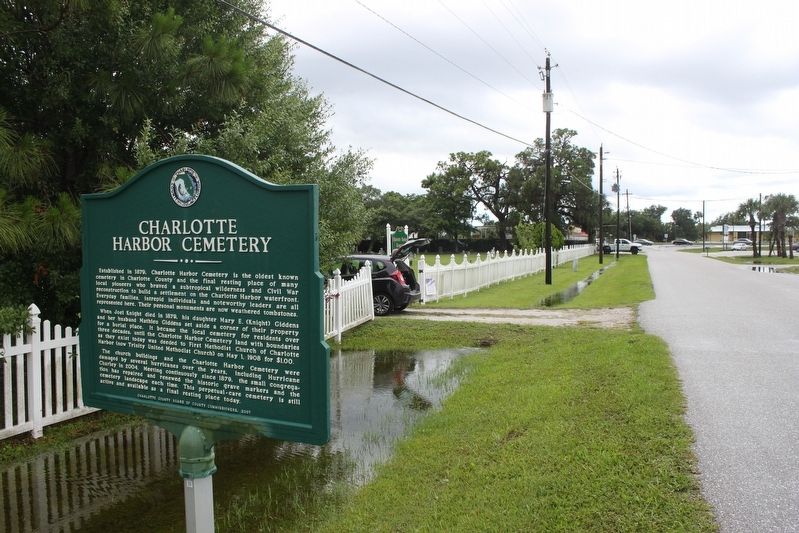
On Church Street just south of Harper Avenue, on the right when traveling north.
Established in 1879, Charlotte Harbor Cemetery is the oldest known cemetery in Charlotte County and the final resting place of many local pioneers who braved a subtropical wilderness and Civil War reconstruction to build a settlement on the . . . — — Map (db m101018) HM
On Rowland Drive 0.1 miles north of Harbor View Road, on the left when traveling north.
The Hickory Bluff Cemetery was established in the late 1800s, adjacent to land purchased on June 2, 1884 by July Roberts, an early African-American settler. Initial burials began following the Civil War when freed African-Americans settled in the . . . — — Map (db m128325) HM
After the Civil War (1861-1865), soldiers stationed in Florida decided to stay for the warm climate as well as for political and financial gain. Some became early pioneers here in Hickory Bluff, not far from the 1872 Charlotte Harbor post office. . . . — — Map (db m101021) HM
On Seneca Avenue at Parmely Street, on the right when traveling north on Seneca Avenue.
A congregation has met at Trinity United Methodist Church continuously since 1873. The first church organized in today's Charlotte County, its members have been an integral part of our history. Joel and Jesse Knight, James McKay and Jacob Summerlin . . . — — Map (db m101019) HM
On Kerrigan Circle 0.1 miles west of El Jobean Road (Florida Route 776), on the left when traveling south.
During the American Civil War in late 1863, Union forces and "refugee rangers" encountered local combatants in a brief skirmish on the eastern shore of the Myakka River near today's El Jobean. It is the only recorded Civil War skirmish within the . . . — — Map (db m151053) HM
On New Point Comfort Road 0.1 miles south of South McCall Road (Florida Route 776), on the right when traveling south.
The Bass Biological Laboratory and Zoological Research Supply Facility Company was established on this site c. 1931 by John Foster Bass, Jr. (1897-1939) and his wife Else Bass (1898-1973). As the first full-time marine station on the Florida . . . — — Map (db m151045) HM
On Lemon Bay Road just east of Riverside Drive, on the left when traveling west.
1891: Colonel James M. Lewis built a hunting lodge near here on Deer Creek and named it "New Point Comfort" after his boyhood home, Old Point Comfort. in Virginia.
1893: The Gottfried family from Milwaukee settled on Deer Creek, now named . . . — — Map (db m255693) HM
Near Placida Road (County Route 775) 0.3 miles south of Health Drive, on the right when traveling south.
The unique "Cookie House" was built c. 1931 by John Foster Bass, Jr. (1897-1939) founder of the Bass Biological Laboratory and Zoological Research Supply Company, to serve as his personal office and laboratory near the Bass home on New Point Comfort . . . — — Map (db m151050) HM
Near Tamiami Trail (U.S. 41) 0.1 miles south of County Route 776A.
In 1905, Clarence Bloomfield Moore (1852-1936), a wealthy, amateur archaeologist from Philadelphia excavated a mound located on the northern bank of the Peace River about one half mile north of this site. Moore found the sand burial mound containing . . . — — Map (db m152615) HM
Near Murdock Circle 0.1 miles south of Tamiami Trail (U.S. 41).
Inspired by the completion of the Charlotte Harbor and Northern Railroad (CH&N) in 1907, land speculator John Milton Murdock (1867-1925) platted the village of Murdock in 1914. Located at the southwest intersection of US 41 (Tamiami Trail) and the . . . — — Map (db m152660) HM
Near Gasparilla Road (County Route 771) 0.1 miles south of South McCall Road (Florida Route 776).
The Placida Bunk House was built about 1907 by the Charlotte Harbor & Northern Railroad to house their employees. The line was laid to transport phosphate to docks at South Boca Grande on Gasparilla Island. Several families called the building home, . . . — — Map (db m152668) HM
On McClellan Avenue 0.1 miles north of Black Avenue, on the right when traveling north.
The Southland Trail Cemetery, believed to be a non-white cemetery, serves as the final resting place for an undisclosed number of leased convict laborers, blacks and possibly 18th century Spanish-Indian fishermen. The age of the cemetery is unknown; . . . — — Map (db m151056) HM
On Elkcam Boulevard at McGuire Avenue, on the right when traveling north on Elkcam Boulevard.
Arthur C. and Patti Frizzell were ranchers and entrepreneurs who brought in the first Brahman (or Brahma) cattle to the area to improve their herd. They owned over 80,000 acres of land for cattle, turpentine, lumber, and various businesses in . . . — — Map (db m256035) HM
Near Gasparilla Road (County Route 771) 0.1 miles south of South McCall Road (Florida Route 776).
In 1905, the Charlotte Harbor and Northern Railroad (CH&N) built a depot and section house along its rail line from the phosphate mines at Mulberry to the port of Boca Grande. The CH&N Railroad platted the town of McCall in 1909 and named it for . . . — — Map (db m152664) HM
Near Harbor Walk Drive 0.1 miles north of Nesbit Street.
Dedicated to the men of the
83rd Inf Division
WWII
Co F. 329th 2nd Bat.
Fl. Charter organized in
Punta Gorda 1978
by Bill Nickell & Lola Keller — — Map (db m243969) WM
On West Marion Avenue at Harvey Street, on the left when traveling north on West Marion Avenue.
A founder of Punta Gorda, he was a resident until his death. Served as a member of the Florida House of Representatives in 1893, 1895, 1903 and was House Speaker in 1905. He resigned as Brig. Gen. of the Florida Militia and enlisted as a Private in . . . — — Map (db m167300) HM
Near Harbor Walk Drive 0.1 miles north of Nesbit Street.
American Merchant
Marine Veterans
Suncoast Chapter
Dedicated to the
six thousand eight hundred
and thirty-four
Merchant Seamen who lost
their lives in World War II — — Map (db m243905) WM
On Bayshore Road at Parmely Street, on the left when traveling west on Bayshore Road.
Charlotte Harbor has provided food, industry, leisure, and transportation since pre-historic times. The first bridge connecting the towns of Charlotte Harbor and Punta Gorda opened in 1921, but was barely wide enough for two cars to pass.
In 1931, . . . — — Map (db m280927) HM
On Taylor Street at Olympia Avenue, on the right when traveling north on Taylor Street.
Charlotte County was created in 1921, after citizens had pushed for 34 years to divide DeSoto County, and Punta Gorda was the new county seat. After meeting in rented quarters, the Board of County Commissioners voted in 1927 to plan a new building . . . — — Map (db m189589) HM
Near Harbor Walk Drive at Nesbit Street, on the right when traveling east.
Flag Pole and U.S. Flag donated to all
veterans of Charlotte County by
Charlotte Detachment #756
Marine Corps League
4 July 1996 — — Map (db m256233) WM
On Cooper Street at East McKenzie Street, on the right when traveling north on Cooper Street.
Originally named the Punta Gorda High School, this building was the first dedicated high school for the newly created Charlotte County (1921), replacing the previous 1907 Punta Gorda Grammar and High School. Construction of the school began in 1926 . . . — — Map (db m215977) HM
On West Marion Avenue at Goldstein Street, on the left when traveling north on West Marion Avenue.
Spanish fishermen from Cuba first gave the name "Punta Gorda" to this area in the early 1800's. The City was originally platted as "Trabue" by Isaac H. Trabue on February 24, 1885. The City of Punta Gorda came into being when a group of men met in a . . . — — Map (db m167299) HM
On Ponce de Leon Parkway 0.5 miles south of North Marion Court, on the right when traveling south.
Many wading birds can be seen here, largely due to the sacrifice of men like Columbus G. McLeod (1848-1908), who gave his life trying to protect them from plume hunters. Ladies' hats with exotic bird feathers were high fashion for the late 1800's, . . . — — Map (db m167589) HM
Near Harbor Walk Drive 0.1 miles north of Nesbit Street.
Dedicated to the memory of P.F.C. Robert L. Cochran
U.S.M.C. Killed in action on the Island of Saipan,
1944, and to all Combat Wounded Veterans
My stone is red for the blood they shed.
The medal I bear is my country’s way to show . . . — — Map (db m244062) WM
Near West Virginia Avenue at Berry Street, on the right when traveling north.
This block of concrete is a foundation remnant of the Consolidated Ice Manufacturing, Refrigeration and Fish Co., which once occupied two full city blocks. Built in 1903 to supply cooling for fish products, the ice plant was the second largest in . . . — — Map (db m249202) HM
On Ponce De Leon Parkway 0.5 miles south of North Marion Court, on the left when traveling south. Reported permanently removed.
April 2 - Discovery of "La Florida"
April 20 - Punta de Arracifes (Cape Kennedy)
April 21 - The Gulf Stream currents
May 8 - Cabo de Corrientes (Palm Beach)
May 13 - Bahia Chequescha (Biscayne Bay)
May 15 - Los Martires (The Florida Keys) . . . — — Map (db m167681) HM
On West Retta Esplanade at Harvey Street, on the left when traveling north on West Retta Esplanade.
On June 22, 1876, James A. Lockhart and his wife Josephine chose this location to build their new home, which was described as the lowest location in the area, near the only pine trees on the clearing and adjacent to a shell mound. The couple camped . . . — — Map (db m167303) HM
On Ponce de Leon Parkway 0.9 miles west of Colony Point Drive, on the right when traveling south.
On this day, May 24, ships were sent to seek a mainland colony site and to sound and chart the newly found “Bay of the Holy Spirit” (Charlotte Harbor). For three weeks explorations continued, seldom by land. There were at least three . . . — — Map (db m95500) HM
On Taylor Street at Olympia Avenue, on the left when traveling north on Taylor Street.
On December 3, 1887, 34 men in the "Town of Trabue" met here in a two-story building, built in 1887, owned by Tom Hector. The diverse group of landlords, tenants, merchants and workers, some white and some black, were all qualified voters. At the . . . — — Map (db m167271) HM
Near Maud Street north of West Retta Esplanade, on the left when traveling north.
This anchor was discovered by Out Island Divers & Salvage Company July 11, 1979 in Boca Grande Pass, Florida, in 60 feet of water, resting on a flat rock. Weighing approximately 2000 pounds, this anchor is believed to be made prior to 1815 based on . . . — — Map (db m249210) HM
On Howard Street at Shore Drive, on the left when traveling north on Howard Street.
Frederick William Howard of Kinderhook, New York, first settled near this site in November 1873. After their marriage, Frederick and his wife Anna established residence here in January 1874, along with their two nephews. Frederick hired men and an . . . — — Map (db m167522) HM
On Indian Springs Cemetery Road at Ferncroft Avenue, on the left when traveling south on Indian Springs Cemetery Road.
Indian Spring Cemetery, also called Indian Springs, was created in 1886 on land donated by James L. Sandlin (1858-1903), who settled on Alligator Creek in 1884. Additions were recorded in 1891, 1931, 1974 and 1975. The name "Indian Spring" came from . . . — — Map (db m189588) HM
Near East Retta Esplanade near Tamiami Trail (U.S. 41).
This plaque honors Isaac H. Trabue, the founder of the town of “Trabue” which became the City of Punta Gorda.
Trabue, born on March 25, 1829 was a lawyer, coal mine operator, Union soldier during the Civil War, and land developer. He was . . . — — Map (db m249134) HM
Near Ponce de Leon Parkway 0.9 miles west of Colony Point Drive, on the right when traveling south.
Born - San Tierra de Campos, Palencia, Spain - 1460
Died - Havana, Cuba - (probably Mid-June) - 1522
Interred - Entombment beneath the high altar of the Dominican Cathedral of San Juan, Puerto Rico.
Epitaph to Ponce de Leon
"Beneath . . . — — Map (db m95486) HM
On West Retta Esplanade at Harvey Street on West Retta Esplanade.
Juan Ponce de Leon was the first Spanish explorer to arrive in Florida. Early Spanish explorers were known as Conquistadors or conquerors. While there are no official records, it is believed that Ponce de Leon was born the year of 1460 in Santervas . . . — — Map (db m280907) HM
On Scott Avenue just north of Duncan Road (U.S. 17), on the left when traveling north.
Lt. Carl Bailey Cemetery has served this area’s African-American community as a final resting place for over 120 years. The cemetery was called the Cleveland Cemetery, established in the 1880s on land owned by New York investor W. Irving Scott. The . . . — — Map (db m151119) HM
On Ponce De Leon Parkway 0.6 miles south of North Marion Court when traveling south. Reported missing.
In Charlotte Harbor Ponce de Leon came upon an urban Indian culture over 200 years old! The Caloosas were "City dwellers" whose sea-oriented high, dry, airy rectangular dwelling mounds made pleasant and secure homesites. Skillful engineers, the . . . — — Map (db m167684) HM
On Ponce de Leon Parkway 0.6 miles south of North Marion Court, on the left when traveling south. Reported permanently removed.
On his first voyage to Florida in 1513, Juan Ponce de Leon spent several weeks at or near the mouth of Charlotte Harbor. When attacked by Indians he returned to Puerto Rico. In 1521, Ponce de Leon, with two shiploads of colonists, returned to . . . — — Map (db m167594) HM
On Ponce de Leon Parkway 0.5 miles south of North Marion Court, on the right when traveling south. Reported missing.
The first European settlement in what is now the United States was established on the shores of Charlotte Harbor by explorer Juan Ponce de Leon and a band of more than 200 soldiers, priests, farmers, artisans and monks. The colony lasted for about . . . — — Map (db m167676) HM
Near Airport Road 0.3 miles east of Piper Road, on the right when traveling north.
In May 1942, the Army Air Corps chose this site for the Punta Gorda Army Air Field (PGAAF). Construction began that October at a project cost of $700,000.
The Army Air Corps activated PGAAF on December 11, 1943 with a mission to train pilots . . . — — Map (db m146927) HM
On Carmalita Street west of Taylor Road, on the right when traveling east.
On June 11, 1996, the Punta Gorda Atlantic Coast Line Depot was donated by Fred Babcock, Babcock Enterprises, Inc. to Old Punta Gorda, Inc. dba Punta Gorda Historical Society. Local historian and descendant of original African American settlers to . . . — — Map (db m256036) HM
On Taylor Road at Carmalita Street, on the right when traveling south on Taylor Road.
Plans to build the railroad depot in Punta Gorda began in 1928. Although the trains carried passengers, the main purpose was for shipping fish to northern markets. The Punta Gorda depot is the only remaining one of this style built by the Atlantic . . . — — Map (db m167353) HM
The first Spanish fishermen sailed their smacks into Charlotte Harbor in the 18th century marking the beginning of a commercial fishing industry. Cuban fishermen controlled the business for over 200 years until the United States took possession of . . . — — Map (db m249131) HM
On Kings Highway at Harborview Road, on the right when traveling east on Kings Highway.
Schoolhouse Square Shopping Center
Developed by Lewis Property Investors, Inc.
Tampa, Florida
1988
Dedicated in Commemoration of the Charlotte Harbor
School Which Stood on this Site and Operated from 1917
to 1950, Honoring . . . — — Map (db m280060) HM
On W Marion Ave at Taylor St, on the right when traveling west on W Marion Ave. Reported missing.
Hotel Punta Gorda, one the first buildings of any kind constructed in Punta Gorda, opened in January 1888 and served over 3300 guests within its first season. The three story building contained 150 rooms, all with a view of the waters of Charlotte . . . — — Map (db m216054) HM
On West Marion Avenue 0.1 miles west of Bal Harbor Boulevard, on the right when traveling west.
On this site, in 1887, ended the southernmost railroad trackage in the U.S. Florida Southern Railway's narrow-gauge tracks ran out on a 4,000 foot "Long Dock," where connections were made to New Orleans, Key West, and Havana steamers of the Morgan . . . — — Map (db m167520) HM
On Ponce de Leon Parkway 0.6 miles south of North Marion Court, in the median.
"And believing that this land was an island, they named it La Florida, because it had a very beautiful view of many and cool woodlands, and because, moreover, they discovered it in the time of the Feast of the Flowers (Pascua Florida) Juan Ponce . . . — — Map (db m167588) HM
In 1902 town founder, Isaac Trabue, convinced a group of Philadelphia investors to build the town’s third ice factory, the Consolidated Ice Manufacturing, Refrigerating and Fish Company. Their plan was to furnish cheaper ice to fishermen and also . . . — — Map (db m249130) HM
On Tamiami Trail (U.S. 41) just north of West Marion Avenue, on the right when traveling south.
The Punta Gorda Bank was operating by June 1894 as a branch of the State Bank of Fort Meade. It was chartered by the state as a separate bank in July 1899, with a capital of $15,000 and Perry Wadsworth McAdow as president. McAdow had earned a . . . — — Map (db m167301) HM
In 1885 Isaac Trabue registered the land that he had purchased and platted in 1884 in Manatee County as the town of “Trabue.” In 1887, it would become Punta Gorda. He named some twenty streets in the new town after relatives, including Retta . . . — — Map (db m249138) HM
Near Harbor Walk Drive 0.1 miles north of Nesbit Street.
In honor of
the men and women
who served.
Jewish War Veterans of America
Oskar Schindler Post #404
Port Charlotte, Florida
100th Anniversary 1896-1996
— — Map (db m244052) WM
Near Harbor Walk Drive 0.1 miles north of Nesbit Street.
Vietnam Veterans
of America #665
Honors all past
present and past
men and women veterans
of Charlotte County
Never Forget Our MIA-POW’s — — Map (db m243997) WM
Near Harbor Walk Drive 0.1 miles north of Nesbit Street, on the right when traveling north.
Women’s Overseas
Service League
We were there because we cared.
We continued in order to
keep alive the spirit that prompted
our overseas service.
League founded in 1921 — — Map (db m256285) WM
After the last of the old fish companies on the Maud Street Dock, the Punta Gorda Fish Company, ceased operation in the late 1970s, the dock fell into ruin. Earl Nightingale, a famous radio personality of the day, discovered the rundown pier with . . . — — Map (db m249111) HM
What was said to have been the first big game fish, a silver tarpon, was taken by ordinary rod and reel in 1885 by W.H. Wood. Articles about the feat in the London Observer and Scientific American launched the new sport of big game fishing and . . . — — Map (db m249110) HM
Between 1889 and the early 1900’s, the primary means of transportation south and west of Punta Gorda was by boat.
During the winters at the turn of the 20th century, many yachts could be seen anchored near the shores of Punta Gorda. Naphtha . . . — — Map (db m249113) HM
Near Maud Street near West Retta Esplanade, on the right.
The Railroad Dock at the foot of King Street (now U.S. 41 North) was the hub of Punta Gorda’s commercial activity from 1897 until 1928. In addition to being the commercial seafood center, it was the port for steamers connecting with the railroad. . . . — — Map (db m249108) HM
In 1886, after Isaac Trabue persuaded the Florida Southern Railroad directors to locate their railroad down the east side of the Peach River, track was extended along what is now the linear park to beyond the original town of Trabue. There, a . . . — — Map (db m249112) HM
Fishermen’s Village is located on the site of the former Maud Street Dock. The Dock was built in 1928 to replace the King Street Pier, home to t the Punta Gorda fishing industry. The old pier had been removed to make way for the new Barron Collier . . . — — Map (db m249128) HM
On March 26, 1917, an enthusiastic crowd of over a thousand people gathered to welcome the former President of the United States, Theodore Roosevelt, to Punta Gorda. He had come to conquer the “devil fish.”
Roosevelt had been drawn to Punta . . . — — Map (db m249125) HM
Near Dr Martin Luther King Jr Boulevard at East Virginia Avenue, on the left when traveling north.
The Bailey Brothers served the United States of America honorably World War II, the Korean War and the Vietnam War
Archie and Josephine Bailey were married in 1905 and made Punta Gorda their home. They raised their large family in their . . . — — Map (db m249137) HM
On North Citrus Springs Boulevard, on the right when traveling east.
Dedicated to all those living or dead who served their country in time of conflict In memory of those who made the Supreme Sacrifice. — — Map (db m239990) WM
Near North Museum Point 0.1 miles south of West State Park Street, on the right when traveling north.
Main Burial Complex (Mounds C-F)
Have you ever visited a cemetery? The mounds and raised features here are a graveyard for Native Americans who buried their dead at this site 1,000 to 3,000 years ago. The large, central mound contains . . . — — Map (db m267590) HM
On North Museum Point 0.1 miles south of West State Park Street, on the right when traveling north.
Midden Area
In this area more than a thousand years ago, people built their homes, raised their families, made tools, and prepared meals. All this human activity created a midden, or built-up area made of the bits and pieces of their . . . — — Map (db m268160) HM
Near North Museum Point 0.1 miles south of West State Park Street, on the right when traveling south.
Sand Burial Mound (Mound G)
The burials located here shared little in common with those from the Main Burial Complex on the other side of the plaza. The people buried here had no elaborate grave goods, but were laid to rest with shells, . . . — — Map (db m267585) HM
On North Museum Point 0.1 miles south of West State Park Street, on the right when traveling north.
A View from the Top
Much like an arena or stadium in a big city, Mound A served as a symbol of grandeur that would impress visitors to this site.
From the flat top of the mound, public performances, speakers, or ceremonies would . . . — — Map (db m268143) HM
On North Citrus Avenue 0.1 miles west of North Suncoast Boulevard (U.S. 98), on the right when traveling south.
On July 3, 2023, the 100th anniversary of the City of Crystal River's incorporation as a City, at this location, the Mayor convened a special meeting of the City Council. The Mayor issued a proclamation formally dedicating the City, Home of the . . . — — Map (db m267568) HM
Near North Museum Point 1 mile south of West State Park Street, on the right when traveling north.
The ancient Native peoples who built these mounds lived at Crystal River for more than a thousand years from around AD 50 to AD 1050.
Archaeologists think of this as a village where people lived, but also as a place where visitors came to . . . — — Map (db m267354) HM
On Northeast Crystal Street at Northeast 1st Avenue, on the right when traveling east on Northeast Crystal Street.
At one time, and for many years until the 1950's, Crystal Street was the main thoroughfare into Crystal River for travelers coming from Lecanto and Inverness. In 1907, because of its role as the gateway into Crystal River, a group of ladies from the . . . — — Map (db m121120) HM
Near North Suncoast Boulevard (U.S. 19) 0.3 miles north of West Cornflower Drive, on the right when traveling north.
A Man-made Lake Felburn Park was once a mine. Workers mined dolomite rock, which was added to soil on farms. As they dug, miners hit a reservoir of groundwater, and the spring water started to fill the pit. They pumped out the water as it . . . — — Map (db m167344) HM
On Northeast Crystal Street at Northeast 1st Avenue, on the left when traveling east on Northeast Crystal Street.
The first railroad depot in Citrus County was located on this site soon after the completion of the county's first rail line from Dunnellon in 1887. Constructed by the Silver Springs, Ocala and Gulf Railroad, the spur line would be continued to . . . — — Map (db m121118) HM
On Northesat 3rd Street 0.1 miles west of North Citrus Avenue.
Edwin and Mary King moved to Crystal River in 1863. They built a home nearby on the bay which came to bear their name. In 1879, a canal on the north side of the property was dug so that smaller boats could unload supplies from larger ships at the . . . — — Map (db m237202) HM
On NE Third Street near NE 2nd Avenue, on the right when traveling west.
In the early 1920s, Frederick VanRoy, a successful Crystal River businessman, encouraged residents from his home state of Michigan to spend their winters in the growing town where he settled over a decade before.
Most of the early residents . . . — — Map (db m295504) HM
Near North Museum Point 1 mile south of West State Park Street, on the right when traveling north.
Flat-Top Mound and Plaza (Mound H)
Imagine watching a sermon, speech, or performance atop the mound in front of you as you stand among members of your family and community in the flat, open plaza. Native peoples used this 12-foot-high . . . — — Map (db m267608) HM
On NE Third Street west of NE 2nd Avenue, on the right when traveling west.
In the early 1920's, people from Michigan began spending winters in Crystal River, encouraged by local businessman Frederick Van Roy. Many built homes in a two-block area which became known as Michigan Town.
In 1924, a group of these folks . . . — — Map (db m295501) HM
Near North Museum Point 0.1 miles south of West State Park Street, on the right when traveling north.
Lagoon
As you listen to the sound of the Crystal River as it flows by, imagine yourself here a thousand years ago when Native Americans once called this place home. Native peoples utilized a natural lagoon located where you are standing . . . — — Map (db m267613) HM
On Withlacoochee Bay Trail 4.6 miles west of North Suncoast Boulevard (U.S. 19).
The Price of Progress Picture massive barges, tugboats and trawlers clogging the bay. This was to be the west end of the Cross Florida Barge Canal, where the water enters the Gulf of Mexico. The canal would have impacted Florida's fresh and . . . — — Map (db m167343) HM
Near West Withlacoochee Trail (County Road 39) just east of North Florida Avenue (U.S. 41), on the left when traveling east.
A Rocky Past Today, the old railroad bed beneath the Dunnellon Trail carries walkers and bicyclists. In the late 1800s, it moved train cars laden with phosphate rock. Prospectors discovered the valuable mineral here in 1889, sparking an . . . — — Map (db m167502) HM
Near East Orange Avenue (County Road 48) just east of South Florida Avenue (U.S. 41), on the left when traveling east.
[north-facing kiosk panel] Introduction Records of colonial explorers reveal a well-developed Native American trail linking the Tampa Bay area to the village of Alachua, 150 miles to the north. A Timucuan village existed along this . . . — — Map (db m168617) HM
On East Orange Avenue (County Road 48) at South Aroostook Way, on the left when traveling west on East Orange Avenue.
(Side 1)
The area containing present day Floral City has been inhabited by
humans for thousands of years. When Hernando De Soto came through
the area in 1539, he found the Indian village of Tocaste. From the late
1700s until the Second . . . — — Map (db m104967) HM
On South Old Floral City Road 0.2 miles north of Kabrich Road, on the left when traveling north.
Three-sided concrete posts were placed every mile along the railroad as points of reference for the trainmen. This post tells us that it is 800 miles via rail to Richmond, Virginia, the railroad company’s headquarters.
Funding for . . . — — Map (db m125492) HM
Near South Istachatta Road (County Road 39) north of East Waller Lane, on the right when traveling north.
You are standing on the site of one of the worst train disasters in Florida history. The tragedy occurred October 18, 1956, on a dark and foggy morning in Pineola. At 5:12 a.m., people from five miles around were awakened when two freight trains . . . — — Map (db m101820) HM
On E. Orange Ave. (County Road CR48) at S. Floral City Rd., on the right on E. Orange Ave..
This house is the oldest surviving residential structure
in Citrus County. It was purchased in 2012 by the
Duval Preservation Trust, a non-profit institution
organized for the purpose of restoration and
preservation of this historic gem.
Tax . . . — — Map (db m104980) HM
On East Orange Avenue (County Road 48) at South Old Floral City Road, on the right when traveling east on East Orange Avenue.
In 1863 John Paul Formy-Duval and his wife Elizabeth Ann Trantham bought land from Allen Munden and began building their home. During the process of construction, the Duvals discovered that they had been building their house a few hundred yards . . . — — Map (db m119137) HM
On East Orange Avenue / South Duval Island Drive east of South Shore Acres Point, on the right when traveling east.
It’s July 24, 1539…
Hernando de Soto’s army has set up camp at a nearby Indian village, Tocaste -
I moved ahead with a small scouting party. Just north of the village, we discovered a broad road, which I believe may be the entrance . . . — — Map (db m126576) HM
Near South Istachatta Road (County Road 39) at East Thomas Road.
Whistle markers were placed along the track ¼ mile before every road crossing, in both directions. They alerted the engineer to blow his train whistle. The horizontal bars on this concrete whistle marker — two wide, one narrow, one wide — tell the . . . — — Map (db m156006) HM
On North Florida Avenue (U.S. 41) at East Parsons Point Road, on the right when traveling north on North Florida Avenue.
(side 1)
Church of the Nazarene Hernando
Hernando, named for Spanish explorer Hernando de Soto, was founded in 1881 by the Croft and Van Ness families. Beside the Tsala Apopka lakes their citrus groves thrived. Development followed . . . — — Map (db m112147) HM
On North Florida Avenue (U.S. 41) at East Parsons Point Road, on the right when traveling north on North Florida Avenue.
The Hernando Elementary School is a one-story masonry building erected between 1941 and 1942 through county and state cooperation with the Works Progress Administration (WPA). This red brick school is situated on land that was acquired through a . . . — — Map (db m236678) HM
1271 entries matched your criteria. The first 100 are listed above. Next 100 ⊳