By William Fischer, Jr., July 31, 2015
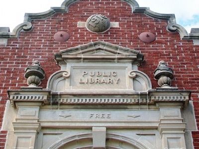
Bedford Public Library Facade Detail
| On Jefferson Street east of Madison Street (Iowa Highway 148), on the left when traveling east. |
| On Neosho Street at 2nd Street, on the right when traveling west on Neosho Street. |
| On Prairie Street at Orange Street, on the right when traveling west on Prairie Street. |
| On 9th Street at Vermont Street, on the right when traveling west on 9th Street. |
| On 9th Street at Vermont Street, on the right when traveling west on 9th Street. |
| On 2nd Avenue at Spruce Street, on the left when traveling north on 2nd Avenue. |
| On Main Street south of 5th Street, on the left when traveling south. |
| On Springfield Avenue at Main Street (Kansas Highway 44), on the left when traveling north on Springfield Avenue. |
| On Main Street at 3rd Street, on the left when traveling south on Main Street. |
| On Main Street (State Highway 15) at 2nd Street, on the left when traveling north on Main Street. |
| On Main Street (State Highway 14) at D Avenue (U.S. 54/400), on the left when traveling north on Main Street. |
| On 17th Street at Broadway, on the right when traveling south on 17th Street. |
| On 5th Street south of Walnut Street, on the left when traveling south. |
| On College of Emporia Drive, on the right when traveling west. |
| On Walnut Street at Division Avenue, on the right when traveling north on Walnut Street. |
| On Main Street at Allen, on the right when traveling north on Main Street. |
| On Main Street at Montgomery Street, on the right when traveling east on Main Street. |
| On Morgan Avenue (State Highway 181) at Osborne Street, on the right when traveling south on Morgan Avenue. |
| On Poyntz Avenue at 5th Street, on the right when traveling west on Poyntz Avenue. |
| On 17th Street N at Fairmount Avenue, on the left when traveling east on 17th Street N. |
| On West Walnut Street at College Street, on the right when traveling east on West Walnut Street. |
| On Washington Street at 5th Street, on the right when traveling north on Washington Street. |
| Near Broadway at Library Street, on the right when traveling north. |
| On Center Avenue (State Highway 25) at North Jackson Street, on the right when traveling east on Center Avenue. |
| On North Matteson Street at York Street, on the left when traveling north on North Matteson Street. |
| On East Ludington Street at Iron Mountain Street, on the right when traveling west on East Ludington Street. |
| On Mitchell Street (County Road 58) at Waukazoo Avenue, on the right when traveling west on Mitchell Street. |
| On W. Shiawassee Street, on the right when traveling west. |
| On West Grand River Avenue (Business Interstate 96) at Center Street, on the left when traveling east on West Grand River Avenue. |
| On Macomb Place at Southbound Gratiot Avenue (Michigan Highway 3), on the right when traveling south on Macomb Place. |
| On Maple Street at 1st Street, on the right when traveling north on Maple Street. |
| On Main Street (Michigan Route 53) south of Ervin Street, on the right when traveling south. |
| On 6th Street, on the right when traveling south. |
| On North Main Street (Business U.S. 131) at Moore Street, on the right when traveling north on North Main Street. |
| On S. Kalamazoo Street (State Highway 40) at E. Paw Paw Street, on the right when traveling north on S. Kalamazoo Street. |
| On East Huron Street east of South State Street. |
| Near Washington Avenue at Frazee Street, on the left when traveling north. |
| On Bemidji Avenue North (State Highway 197) at 5th Street Northwest, on the right when traveling north on Bemidji Avenue North. |
| On 7th Street at Washington Street (Minnesota Highway 210), on the right when traveling north on 7th Street. |
| On Main Avenue North (State Highway 32) just north of 1st Street East (County Highway 17), on the right when traveling north. |
| On North Ash Street just north of East Robert Street (U.S. 2), on the right when traveling north. |
| On Como Avenue at Carter Avenue on Como Avenue. |
| On Lincoln Street east of 2nd Avenue North, on the left when traveling east. |
| On Delta Avenue at 1st Street, on the right when traveling north on Delta Avenue. |
| On 13th Street at 28th Avenue, on the right when traveling east on 13th Street. |
| On Adams Street north of High Street, on the left when traveling north. |
| On 3rd Street (State Highway 79) at Tennessee Street, on the right when traveling north on 3rd Street. |
| On North Custer Avenue at 5th Street West, on the right when traveling north on North Custer Avenue. |
| On West Main Street (U.S. 87) near 7th Avenue North, on the left when traveling west. |
| On 2nd Avenue East near 3rd Street East, on the left when traveling south. |
| On State Street near South 3rd Street, on the right when traveling west. |
| On Illinois Street (Lincoln Highway) (U.S. 30) at 8th Avenue, on the right when traveling west on Illinois Street (Lincoln Highway). |
| Near N Street just east of North 7th Street, on the right when traveling west. |
| On South Virginia Street (Nevada Route 430), on the right when traveling north. |
| On Livingston Avenue (New Jersey Route 171) just south of Morris Street, on the right when traveling north. |
| On Exchange Street at Congdon Place, on the left when traveling south on Exchange Street. |
| Near Mother Gaston Boulevard north of Glenmore Avenue, on the right when traveling south. |
| On Glenmore Avenue west of Mother Gaston Boulevard, on the right when traveling west. |
| On Main Street (New York State Route 104) at Ashland Avenue, on the left when traveling north on Main Street. |
| On Pike Street (U.S. 6/209) west of Broome Street, on the right when traveling west. |
| On Forest Parkway at 85th Drive, on the right when traveling north on Forest Parkway. |
| On Croton Avenue (New York State Route 133) north of Elizabeth Street, on the left when traveling north. |
| On Broadway North at 4th Avenue North, on the right when traveling south on Broadway North. |
| On 4th Avenue Northeast just south of 7th Street Northeast, on the right when traveling south. |
| On East Birdsall Street at North South Street (U.S. 68), on the right when traveling east on East Birdsall Street. |
| On East 4th Street, 0 miles west of Broadway Street, on the right when traveling west. |
| On Front Street (Ohio Route 237) 0.2 miles north of Bagley Road (Ohio Route 237). |
| On Columbus Street (Ohio Route 256) at Center Street / Lockville Road, on the right when traveling east on Columbus Street. |
| On Library Park North, on the right when traveling east. |
| On Maplewood Avenue, on the left when traveling east. |
| On 4th Street at Slack Street, on the right when traveling east on 4th Street. |
| On S. Main Street at E. Harrison Street, on the left when traveling south on S. Main Street. |
| On Paint Street, on the right when traveling south. |
| On 3rd Street at Cleveland Avenue SW, on the right when traveling east on 3rd Street. |
| On Broadway, on the right when traveling south. |
| On East Oklahoma Avenue east of North Ash Street, on the left when traveling east. |
| Near W Main St at S Oakland Ave. |
| On North Main Street near Northwest Bailey Avenue, on the right when traveling north. |
| On East 4th Street near Washington Street, on the left when traveling west. |
| On Library Street at Maple Way when traveling south on Library Street. |
| Near 10th Avenue, 0.1 miles west of Andrew Street. |
| On 10th Street, 0.1 miles west of Andrew Street, on the left when traveling west. |
| Near Allegheny River Boulevard at Pennsylvania Avenue, on the right when traveling north. |
| Near Allegheny Square East west of East Ohio Street. |
| Near Schenley Drive Extension. |
| On Seventh Avenue (Pennsylvania Route 18) at 13th Street on Seventh Avenue. |
| On Pattee Mall west of Pollock Road, on the left when traveling west. |
| On East South Street just west of South Carnegie Avenue, on the left when traveling west. |
| On South Pittsburgh Street just north of Baldwin Avenue, on the right when traveling north. |
| On East Wyoming Avenue at "B" Street on East Wyoming Avenue. |
| On Linden Avenue at State Road, on the right when traveling south on Linden Avenue. |
| On Pennypack Path, 0.5 miles south of State Road, on the right when traveling east. |
| On K&T Trail at Levick Street, on the right when traveling east on K&T Trail. |
| On K&T Trail north of Walbach Street, on the right when traveling north. |
| On North Shirley Avenue, on the left when traveling east. |
| On Craven Street at Carteret Street (Business U.S. 21), on the left when traveling east on Craven Street. |
| On North Limestone Street (State Highway 150), on the right when traveling north. |
266 entries matched your criteria. Entries 101 through 200 are listed above.
⊲ Previous 100 —
The final 66 ⊳