By Cajun Scrambler, July 10, 2015
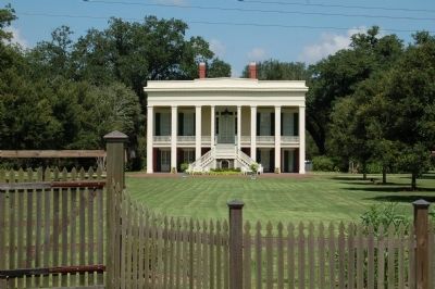
Bocage Plantation
| On River Road (State Highway 942) at St. Elmo Street (Parish Route 1435), on the right when traveling south on River Road. |
| Near River Road (State Highway 942) 1 mile north of State Highway 44, on the right when traveling north. |
| Near State Highway 942 0.3 miles west of Stafford Levy Road, on the right when traveling west. Reported missing. |
| On River Road (State Highway 44) 1.2 miles north of Sunshine Bridge (State Highway 70), on the left when traveling south. |
| On Lessard Street at Williams Street, on the right when traveling north on Lessard Street. |
| On Railroad Avenue near Charles Street, on the right when traveling north. |
| On Mississippi Street (State Highway 18) at St. Vincent Street, on the left when traveling north on Mississippi Street. |
| Near Mississippi Street north of Church Street, on the left when traveling north. |
| On Mississippi Street (State Highway 18) at Iberville Street, on the left when traveling north on Mississippi Street. |
| On Railroad Avenue at Charles Street, on the right when traveling north on Railroad Avenue. |
| Near Opelousas Street east of St. Vincent Street, on the right when traveling east. |
| On Williams Street near Lessard Street. |
| On Chetimatches Street north of Opelousas Street, on the right when traveling north. |
| On Lessard Street at Williams Street, on the right when traveling north on Lessard Street. |
| On Mississippi Street (State Highway 18) near Crescent Park Circle, on the right when traveling south. |
| On Mississippi Street near Crescent Park Drive, on the left when traveling north. |
| On Houmas Street north of Opelousas Street, on the left when traveling north. |
| On Mississippi Street (State Highway 18) at Iberville Street, on the left when traveling north on Mississippi Street. |
| On Charles Street east of Lessard Street, on the right when traveling east. |
| On Mississippi Street (State Highway 18) near Iberville Street, on the right when traveling north. |
| Near Mississippi Street (State Highway 18) at Iberville Street, on the left when traveling north. |
| Near Mississippi Street (State Highway 18) at Iberville Street, on the left when traveling north. |
| On Nicholls Street at Houmas Street, on the right when traveling east on Nicholls Street. |
| On Williams Street east of Lessard Street, on the right when traveling east. |
| Near Mississippi Street (State Highway 18) near Crescent Park Circle, on the right when traveling north. |
| On Nicholls Street near Houmas Street, on the left when traveling north. |
| On Williams Street east of Lessard Street, on the left when traveling east. |
| Near Mississippi Street near Crescent Park Circle, on the right when traveling north. |
| On State Highway 1 0.2 miles south of State Highway 943, on the right when traveling south. |
| Near Williams Street east of Lessard Street, on the right when traveling east. |
| On Williams Street east of Lessard Street, on the left. |
| Near Mississippi Street (State Highway 18) at Iberville Street, on the left when traveling north. |
| On Railroad Avenue north of Opelousas Street, on the left when traveling north. |
| On Ashland Road (State Highway 3251) 0.2 miles east of River Road (State Highway 75), on the right when traveling west. |
| On Ashland Road (State Highway 3251) 0.2 miles east of River Road (State Highway 75), on the right when traveling west. |
| Near South Irma Boulevard 0.3 miles north of East Worthey Street, on the right when traveling north. |
| Near South Irma Boulevard 0.3 miles north of East Worthey Street, on the right when traveling north. |
| Near South Irma Boulevard 0.3 miles East Worthey Street, on the right when traveling north. |
| Near South Irma Boulevard 0.3 miles East Worthey Street, on the right when traveling north. |
| On South Irma Boulevard 0.5 miles south of East Worthey Street, on the right when traveling north. |
| Near South Irma Boulevard north of East Worthey Street, on the right when traveling north. |
| Near South Irma Boulevard 0.3 miles East Worthey Street, on the right when traveling north. |
| Near South Irma Boulevard 0.3 miles East Worthey Street, on the right when traveling north. |
| Near South Irma Boulevard north of East Worthey Street, on the right when traveling north. |
| Near South Irma Boulevard 0.3 miles north of East Worthey Street, on the right when traveling north. |
| Near South Irma Boulevard 0.3 miles north of East Worthey Street, on the right when traveling north. |
| Near South Irma Boulevard north of East Worthy Street (Highway 938), on the right when traveling north. |
| Near South Irma Boulevard near East Worthey Street, on the right when traveling north. |
| Near South Irma Boulevard 0.3 miles north of East Worthey Street, on the right when traveling north. |
| Near South Irma Boulevard 0.3 miles north of East Worthey Street, on the right when traveling north. |
| On South Irma Boulevard north of East Worthey Street (Highway 939), on the right when traveling north. |
| Near South Irma Boulevard 0.3 miles East Worthey Street, on the right when traveling north. |
| Near South Irma Boulevard 0.3 miles north of East Worthey Street, on the right when traveling north. |
| Near South Irma Boulevard 0.3 miles north of East Worthey Street, on the right when traveling north. |
| Near South Irma Boulevard 0.3 miles north of East Worthey Street, on the right when traveling north. |
| Near South Irma Boulevard 0.3 miles north of East Worthey Street, on the right when traveling north. |
| Near South Irma Boulevard 0.3 miles north of East Worthey Street, on the right when traveling north. |
| Near South Irma Boulevard 0.3 miles East Worthey Street, on the right when traveling north. |
| Near South Irma Boulevard 0.3 miles north of East Worthey Street, on the right when traveling north. |
| On South Irma Boulevard 0.5 miles north of East Worthey Street, on the right when traveling north. |
| Near South Irma Boulevard 0.3 miles north of East Worthey Street, on the right when traveling north. |
| Near South Irma Boulevard 0.3 miles East Worthey Street, on the right when traveling north. |
| Near South Irma Boulevard 0.3 miles north of East Worthey Street, on the right when traveling north. |
| Near South Irma Boulevard 0.3 miles north of East Worthey Street, on the right when traveling north. |
| Near South Irma Boulevard 0.3 miles north of East Worthey Street, on the right when traveling north. |
| Near South Irma Boulevard 0.3 miles north of East Worthey Street, on the right when traveling north. |
| On River Road (State Highway 405) 0.5 miles south of Preston Lane, on the left when traveling south. |
| On OakGrove-Port Vincent Highway (State Highway 42) at Diez Road, on the right when traveling east on OakGrove-Port Vincent Highway. |
| On Duplessis Road 0.2 miles east of Old Jefferson Highway (Louisiana Highway 73), on the right when traveling east. |
| On State Highway 929 at Prairieville Fair Grounds Road, on the left when traveling east on State Highway 929. |
| On Grand Bayou Road at Louisiana Highway 70, on the right when traveling south on Grand Bayou Road. |
| On State Highway 308 at Freetown Rd., on the left when traveling south on State Highway 308. |
| On State Highway 308 0.2 miles south of Belle Alliance Road, on the left when traveling south. |
| On State Highway 1 at State Highway 1011, on the right when traveling south on State Highway 1. |
| On State Highway 1 at Franklin Avenue, on the right when traveling north on State Highway 1. |
| On State Highway 1 at Franklin Avenue, on the right when traveling south on State Highway 1. |
| On State Highway 1 at State Highway 1008, on the right when traveling south on State Highway 1. |
| On State Highway 1 north of Dr Martin Luther King Drive, on the right when traveling south. |
| On State Highway 308 at Madewood Road, on the right when traveling north on State Highway 308. |
| On State Highway 1 at Franklin Avenue, on the right when traveling south on State Highway 1. |
| On West Bayou Drive 0.3 miles south of Lee Drive, on the right when traveling south. |
| On State Highway 70 at South Bay Road (State Highway 1015), on the right when traveling south on State Highway 70. |
| On Bayou Drive West 0.5 miles south of Lee Drive. |
| On River Road (State Highway 405) 0.7 miles south of Troxclair Drive, on the right when traveling south. |
| On State Highway 1 at Augusta Road (Route 69), on the right when traveling north on State Highway 1. |
| On State Highway 1 south of Cpl. Herman Brown Jr. Street, on the right when traveling north. |
| On State Highway 405 0.5 miles south of Stewart Street, on the right when traveling south. |
| On Belleview Drive (State Highway 75) at Bayou Road (State Highway 3066) on Belleview Drive. |
| Near Point Clair Road (State Highway 141) 1 mile north of Martin Luther King Parkway (State Highway 75), on the right when traveling north. |
| On Point Clair Road (State Highway 141) 1 mile north of Martin Luther King Parkway (State Highway 75), on the right when traveling north. |
| On Point Claire Road (State Highway 141) 1.6 miles south of Marks Lane, on the right when traveling south. |
| Near Point Clair Road (State Highway 141), on the right. |
| On Point Clair Road (State Highway 141) 1 mile north of Martin Luther King Parkway (State Highway 75), on the right when traveling north. |
| On Point Clair Road (State Road 141) 1 mile north of Martin Luther King Parkway (National Highway 75), on the right when traveling north. |
| On Point Clair Road (State Highway 141) 1 mile north of Martin Luther King Parkway (State Highway 75), on the right when traveling north. |
| On Lacroix Rd at McMillian Drive, on the right when traveling north on Lacroix Rd. |
| On Court Street (State Highway 3066) at Church Street (Route 1), on the right when traveling west on Court Street. |
| On State Highway 1 at Schnebelen Street (Route 988), on the right when traveling south on State Highway 1. |
1118 entries matched your criteria. The first 100 are listed above.
Next 100 ⊳
