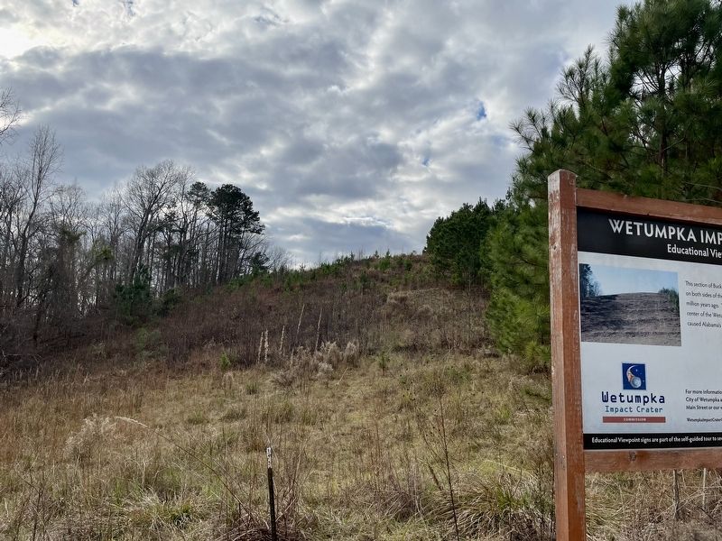
On Buck Ridge Road 0.3 miles south of Harrogate Springs Road, on the right when traveling south.
This section of Buck Ridge Road is unusual because you can easily see hills created on both sides of the road that are related to the impact of a large meteor 85 million years ago. These hills contain large boulders that came to rest near the . . . — — Map (db m189024) HM
On Trotters Trail 0.2 miles south of Fairliewood Drive, on the left when traveling south.
Because of the cleared natural gas pipeline, this area provides an excellent view
of the eastern rim of the Wetumpka Impact Crater. The notch on the far rim is
over a mile away. On the west side of Trotters Trail (behind you) the high point
is . . . — — Map (db m189029) HM
Near Coosa River Parkway, on the left when traveling north.
From a distance, one of the best vistas of the Wetumpka Impact Crater is from the Wetumpka Sports Complex. Your view here is of the highest remains of the northwestern rim of the crater. In the center, several communication towers are located on . . . — — Map (db m189035) HM
On Orline Street west of Hill Street, on the right when traveling south.
The rock layers here in the Coosa River are part of
the deeply eroded western rim of the Wetumpka
Impact Crater. The Coosa River curves around the
rim in the downtown area and these rock layers tilt
away from the crater center, typical of . . . — — Map (db m189038) HM
On North Broad Street at West Coosa Street, on the right when traveling north on North Broad Street.
The Louisville & Nashville Depot was built in Wetumpka in 1906 and exemplifies the L&N plan for small town depots. The station served as a passenger and freight depot until service was terminated in the 1930s and as a freight depot until 1973. In . . . — — Map (db m83724) HM
On West Tuskeena Street at North Broad Street, on the right when traveling west on West Tuskeena Street.
Completed in 1854, this building was the third Methodist Church building erected in Wetumpka and served both black and white congregations. Transitional exterior and interior architecture features elegant simplicity of Greek revival styles. . . . — — Map (db m83725) HM
On Hill Street south of Online Street, on the left when traveling south.
Wetumpka Timeline (Prehistory – 1924)
85 Million Years Ago
A meteor strikes Wetumpka during the age
of the dinosaurs creating a five-mile wide
impact crater blasted into the bedrock.
1714
At the invitation of the Creeks and . . . — — Map (db m222651) HM
On Jackson Trace Road at Hospital Drive, on the right when traveling south on Jackson Trace Road.
In January 1839, Governor Arthur P. Bagby and the State
Legislature enacted a criminal code authorizing a state penitentiary
system for Alabama. A cornerstone was laid in October 1839 on
property purchased adjacent to the Coosa River in Wetumpka . . . — — Map (db m222614) HM
On Orline Street 0.1 miles south of Hill Street, on the right when traveling south.
In 1834, the Wetumpka Toll Bridge Co. built the first of four bridges spanning the Coosa River at this site. It was destroyed in a flood in 1844. A second toll bridge was completed the same year by John Godwin whose slave, Horace King, designed . . . — — Map (db m69449) HM
Near West Fort Toulouse Road 0.2 miles south of Jackson Park Road.
William Bartram, the first native-born American artist-naturalist, of Philadelphia, visited this site on Christmas Day, 1776.
This arboretum commerates (sic) the man, his visit to Fort Toulouse, and his travels through the southeastern . . . — — Map (db m83726) HM
On Jasmine Hill Road at Old Montgomery Highway, on the right when traveling south on Jasmine Hill Road.
1940
One half mile from this site
is the home of
William Lowndes Yancey
1814-1863
American Statesman
Southern Secession Leader
Silver Tongued Orator — — Map (db m71550) HM
On Wall Street (County Road 12) 0.7 miles east of Trone Road, on the right when traveling east.
On land donated by Ed Crosby, a group of African American community leaders had a well dug in January 1955 to provide the people of Gordonville with running water. The Well, the first black-owned water system in Alabama. Initially had just four . . . — — Map (db m207412) HM
On Pine Street at Knight Street, on the left when traveling south on Pine Street.
The church, founded in 1893, played important
roles in the 1960s’ voting rights struggle in
Lowndes County. The second building constructed
in c. 1959 hosted community meetings and voter
registration activities. The Lowndes County
Freedom . . . — — Map (db m285535) HM
On West Tuskeena Street (Alabama Route 21) at South Commerce Street ( Route 97), on the left when traveling west on West Tuskeena Street. Reported missing.
Founded in 1820 by settlers from the Edgefield, Abbeville, and Colleton Districts of South Carolina on property purchased from the U.S. Land Office at Cahaba. Officially named Hayneville in 1831 to honor South Carolina Senator Robert Y. Hayne. . . . — — Map (db m68004) HM
On South Commerce Street (Alabama Route 97) at East Lafayette Street, on the right when traveling north on South Commerce Street.
Johnathan Daniels was murdered near
this spot, then Cash's Store, on
August 20, 1965.
He gave his life in the fight for
integration of the churches
and universal voter registration.
At the time, he
was a divinity student at
The . . . — — Map (db m147604) HM
On East Lafayette Street at South Washington Street, on the left when traveling east on East Lafayette Street.
Lynching in America
Between the end of the Civil War and the close of World War II,
white mobs killed thousands of Black Americans in racial terror
lynchings, and committed widespread violence that traumatized
millions more. The Lowndes . . . — — Map (db m235867) HM
On West Tuskeena Street (Alabama Route 21) at South Commerce Street ( Route 97), on the left when traveling west on West Tuskeena Street. Reported permanently removed.
(front)
1861-1865
The Soldier Dead
of Lowndes
(left side)
No men died there
with more glory.
Yet many died,
And there was much glory.
(right side)
To
Devotion and Valor. . . . — — Map (db m68342) WM
On West Tuskeena Street (Alabama Route 21) at South Commerce Street ( Route 97), on the left when traveling west on West Tuskeena Street. Reported permanently removed.
In the 1820s, Hayneville was known as "Big Swamp." In 1830, after being chosen as the county seat of Lowndes County, it was named Hayneville for Robert Y. Hayne, governor of South Carolina and a U.S. senator. The incorporation of Hayneville as a . . . — — Map (db m305560) HM
On South Commerce Street (Alabama Route 97) south of Oak Street, on the right when traveling south.
On August 20, 1965, Jonathan Myrick Daniels, a 26-year-old
Episcopal seminarian from Keene, New Hampshire, was shot dead
at point blank range here. He was a graduate of Virginia Military
Institute and was attending Episcopal Theological School, . . . — — Map (db m147601) HM
On U.S. 80 at milepost 114 at Steel Haven Road, on the right when traveling east on U.S. 80.
Lowndesboro, AL—Enraged whites, jealous over the business success of a Negro are believed to be the lynchers of Elmore Bolling. Bolling, 39, was found riddled with shot gun and pistol shots 150 yards from his general merchandise store. It is . . . — — Map (db m184279) HM
On North Broad Street (State Road 29) 0.1 miles north of Howard Lane, on the right when traveling north.
Reverend Mansfield Tyler (1826-1904), who was born enslaved near Augusta,
Georgia, organized First Missionary Baptist Church of Lowndesboro in the
late 1860s. He led 137 Black and five White members of Lowndesboro Baptist
Church to establish . . . — — Map (db m304065) HM
On Howard Lane 0.1 miles South Broad Street (County Road 29), on the left when traveling east.
The Lowndesboro School is among the oldest surviving Reconstruction-era
African American schoolhouses in the United States. It was founded in 1867
by Dr. Mansfield Tyler, an educator, minister, and member of the Alabama
House of . . . — — Map (db m245992) HM
On South Broad Street (County Road 29) at Cross Lane, on the right when traveling north on South Broad Street.
Frances Lewis II (1768-1837), a planter, was the first soul to
be interred in this family cemetery. Lewis was born a British
subject in the Colony of Virginia and migrated to Alabama in
the 1820s. The fathers of both Frances Lewis II and his . . . — — Map (db m245991) HM
On North Broad Street 1 mile north of U.S. 80, on the right when traveling north.
Settled before 1820 by planters from South Carolina and Virigina. First called McGill's Hill, it was incorporated, 1832, as Lowndesboro in honor of William Lowndes. There was a brief skirmish here between Forrest's troops and Wilson's raiders, April . . . — — Map (db m70933) HM
On North Broad Street 1.1 miles U.S. 80, on the left when traveling north.
Lowndesboro, Alabama
Lowndesboro developed from a small community of early settlers to a thriving township in the 1830’s. The settlers’ plantation interests were maintained in the lowlands along the Alabama River, while they built their . . . — — Map (db m70934) HM
Near North Broad Street 1.5 miles north of U.S. 80, on the right when traveling north.
In Honor of
Our Confederate Soldiers
1861 1865
Jno Alexander • Wm. Alexander • Wm. H. Alexander • Ed Alexander • Capt. M.F. Bonham • Maj. Bright • Capt. T.B. Brown • Alberta Caffee • Irvin Crocheron • J.P. Caffee • Jim Crocheron • Jno. . . . — — Map (db m85472) WM
On Alabama 21 0.1 miles south of Langston Hughes Road, on the left when traveling south.
Organized in 1850 as Shiloh Baptist Church on the Pritchett
Plantation, later known as the R.D. Spann Place on Highway
21, North, 3 miles north of Hayneville. Primitive later added
to the name. Building originally constructed of logs, then
a . . . — — Map (db m217245) HM
On U.S. 80 at milepost 111, 2.2 miles west of County Road 29, on the right when traveling east.
In memory of our sister Viola Liuzzo who gave her life in the struggle for the right to vote... March 25, 1965 Presented by SCLC/WOMEN Evelyn G. Lowery, National Convener - 1991 - The Southern Christian Leadership Conference Joseph E. . . . — — Map (db m85461) HM
On West Hickory Grove Road 1.3 miles east of Route 97, on the right when traveling east.
Lynching in America
Thousands of black people were the victims of lynching and racial violence in the United States between 1877 and 1950. The lynching of African Americans during this era was a form of racial terrorism intended to . . . — — Map (db m97983) HM
On Snow Hill Drive at Route 21, on the right when traveling west on Snow Hill Drive.
Enslavement & Racial Terror
The enslavement of black people in the United States was a brutal,
dehumanizing system that lasted more than 200 years. Between 1819
and 1860, Alabama's enslaved population grew from 40,000 to 435,000.
According . . . — — Map (db m154554) HM
Threatened by the potential four-to-one advantage of the black vote, whites retaliated by ousting black families from white-owned lands. The African American families who lived here paid dearly to earn their right to vote. Crowded into canvas tents . . . — — Map (db m112400) HM
Since the federal registrars came in August of 1965, thousands and thousands of Negroes have registered to vote. White plantation owners have retaliated by mass evictions. In December 1965, over forty families either left the county, moved in . . . — — Map (db m112405) HM
Monday, March 22, 1965, on the second day of the Selma to Montgomery Voting Rights March, protesters passed this site in late afternoon. At that time the four-lane highway in front of you was only two lanes, and for safety reasons the number of . . . — — Map (db m112375) HM
On Freedom Road (County Road 23) at U.S. 80, on the right when traveling north on Freedom Road.
Six miles North, on December 23, 1813,
General F.L. Claiborne's army defeated
the Creeks and destroyed the Holy
Ground Indian Village. One American
was killed and 33 Creeks. William
"Red Eagle" Weatherford escaped by
leaping on horseback into . . . — — Map (db m60714) HM
Near Holy Ground Road 2.3 miles north of Jones Bluff Road (County Road 40).
One of the significant battles of the Creek War of 1813-14 occurred near here on December 23, 1813. The 3rd Regiment, U.S. Infantry forces under the command of General F. L. Claiborne attacked a band of Creek Indians. Called "Holy Ground" by Creeks . . . — — Map (db m116890) HM
At times history and fate meet at a single time in a single place to shape a turning point in man's unending search for freedom. So it was at Lexington and Concord. So it was a century ago at Appomattox. So it was last week in Selma, Alabama. . . . — — Map (db m112403) HM
While helicopters buzzed overhead, National Guard soldiers—ordered by President Lyndon Johnson to protect the marchers—lined U.S. Highway 80, alert to the potential of violence by angry whites. Marchers walked mile after tired mile, while black . . . — — Map (db m112384) HM
On U.S. 80 at Trickum Cutoff Road, on the right when traveling west on U.S. 80.
The roots of this house of worship date to 1868 when 26 African American members of Mount Gilead Church left to form their own congregation. The present building was constructed in 1901, with several enlargements and renovations throughout the . . . — — Map (db m104068) HM
For African Americans in the 1960s, being kicked off white-owned lands for trying to register to vote no isolated incident. Just as had happened here in Lowndes County, blacks in Tennessee, Mississippi, and Greene County, Alabama, were driven from . . . — — Map (db m112389) HM
In December 1965, a city of tents appeared on this site. The temporary shelters were homes for evicted black sharecropper families. These farmers worked and lived their lives on white-owned farms in Lowndes County. But when they dared to register to . . . — — Map (db m112371) HM
On Flowers Road (County Route 37) 0.1 miles south of Vaughn Road ( Route 110), on the right when traveling south.
Brewer Church began in 1898 with 10 members in a one-room structure at its current location in Cecil, AL. Construction of the sanctuary occurred a few years later. Brewer Church was named for its first pastor, George Evans Brewer, a former State . . . — — Map (db m68744) HM
On Gardner Road (County Road 258) 0.1 miles south of Pisgah Road, on the left when traveling south.
Constituted on August 27, 1842 on this site with six charter members including Moses and Sarah Rushton, Susannah Rushton, William and Emily Miley, and James Gardner. First structure built of logs by master carpenter Jesse Yon on land given by Moses . . . — — Map (db m74732) HM
Near Folmar Parkway south of Bill Joseph Parkway, on the right when traveling south.
Abner McGehee
Born Feb. 17, 1779 in Prince Edward County, VA, nephew of John Scott, founder of Alabama Town which in 1819 joined New Philadelphia to become Montgomery. Reared in the Broad River area of northeast Georgia, he became an . . . — — Map (db m70936) HM
On School Spur Road 0.3 miles south of Pettus Road (County Road 19), on the right when traveling south.
This building was one of fourteen schools constructed in Montgomery County with funding assistance from the Julius Rosenwald Fund. Between 1912-32, Julius Rosenwald, a Jewish philanthropist and CEO of Sears, Roebuck and Company teamed up with Booker . . . — — Map (db m71427) HM
On Federal Road 0.9 miles south of Cloverfield Road (County Road 24), on the left when traveling south.
During the Revolutionary War-era, American naturalist
and artist William Bartram journeyed through the
Southeast studying flora, fauna, and indigenous cultures.
His trek through wilderness territory often followed
established Native American . . . — — Map (db m268660) HM
Atop this hill lies Fair Prospect Cemetery, established in the 1840s as part of Fair Prospect Church. Land was donated for the church and cemetery by Benjamin Mitchell (1765-1848) and his wife Jane Scrimpton Mitchell (1775-1850). The location of . . . — — Map (db m54735) HM
On Old Pike Road 0.1 miles north of Cedar Pines Road, on the right when traveling north.
(Obverse)
The Jonesville Community on Old Pike Road in Mathews, named for wealthy landowner George Mathews from Olgethorp County Ga.
was designated by the Montgomery County Commission on October
16th, 2007 to honor the life and legacy . . . — — Map (db m68716) HM
On Magnolia Drive east of East Drive, on the right when traveling east.
In 1941, Rosa Parks was employed at the Maxwell Field Guest House
(Building 439). Her husband, Raymond Parks, worked at the
Maxwell Barber Shop. At Maxwell Field, the cafeteria, post
exchange, swimming pool, and base trolley system were . . . — — Map (db m267521) HM
On South Hansell Street at Kirkpatrick Avenue, on the left when traveling south on South Hansell Street.
The Cessna 305A (O-1A)
(L-19A) was used extensively
for Forward Air
Controller service in
Southeast Asia.
The “Bird-Dog” was made
available to Civil Air Patrol
from DOD excess sources
and is a proven vehicle in
the . . . — — Map (db m95826) HM WM
On Chennault Circle east of Twining Street, on the left when traveling east.
"Whom shall I send, and who will go for us?...
Here am I. Send me."
Isaiah 6:8
"Here dead lie we because we did not choose to live and shame the land from which we sprung. Life to be sure is nothing much to lose, but young men think it . . . — — Map (db m64566) HM WM
On Ash Street west of Poplar Street, on the right when traveling west.
(Side A)
Air University
The Air Corps Tactical School moved to Maxwell in 1931. Brilliant young officers like Chennault, Eaker, Fairchild, Hansell, Kuter, LeMay, Quesada, and Vandenberg formulated the aerial strategies and tactics . . . — — Map (db m64437) HM
On Maxwell Boulevard at Magnolia Drive, on the right when traveling west on Maxwell Boulevard.
Maj Gen Muir S. Fairchild
February 1946 – May 1948
Maj Gen Robert W. Harper
May 1948 – October 1948
Gen George C. Kenney
November 1948 – July 1951
Lt Gen Idwal H. Edwards
August 1951 – . . . — — Map (db m64368) HM
On Maxwell Boulevard at Magnolia Drive, on the right when traveling west on Maxwell Boulevard.
Post-Vietnam Era marked a turning point for AU. Lt Gen Furlong, AU commander, launched a three year campaign to overhaul the curriculum which became known as “Putting the ‘War’ back into War College.” Between 1975 and 1976 AU gained . . . — — Map (db m64375) HM
On Twining Street north of Ash Street, on the left when traveling north.
Remaining in operation longer than any bomber in U.S. military history, the B-52 was the Strategic Air Command's principal long-range heavy bomber from the time it became operational in 1955. Affectionately known as the BUFF (Big Ugly Fat . . . — — Map (db m64474) HM
On Twining Street north of Ash Street, on the right when traveling north.
In 1941, before Pearl Harbour, President Franklin D. Roosevelt agreed with Prime Minister Winston S. Churchill, to provide flight training for British and Commonwealth pilots in the U.S.A. by the U.S. Army Air Corps.
Over 4,000 pilots were . . . — — Map (db m64476) HM WM
The Cessna T-41 was derived from a standard Cessna Model 172 light aviation aircraft. Between 1965 and 1969 the USAF purchased 211 T-41A variants "off the shelf" for the preliminary flight screening of pilot candidates; another 52 T-41C variants . . . — — Map (db m64482) HM
On Maxwell Boulevard at Magnolia Drive, on the right when traveling west on Maxwell Boulevard.
Charged with developing doctrines and concepts for the employment of air power, AU produced the first basic doctrine manuals for the Air Force. AU also gained notoriety with projects such as Corona Harvest, which studied and developed . . . — — Map (db m64374) HM
On Maxwell Boulevard at Magnolia Drive, on the right when traveling west on Maxwell Boulevard.
To accommodate expansion of programs, a five million dollar construction project began in 1954 to give AU a modern, integrated academic center with a collegiate atmosphere and facilities in keeping with its educational mission.
We’re . . . — — Map (db m64372) HM
On Maxwell Boulevard at Magnolia Drive, on the right when traveling west on Maxwell Boulevard.
The Army Air Forces school was assigned its first commander, Major General Muir S. Fairchild, in February 1946, and renamed Air University in March. The dedication ceremony occurred 3 Sep 1946. The first classes at the Air War College and the . . . — — Map (db m64370) HM
On Maxwell Boulevard at Magnolia Drive, on the right when traveling west on Maxwell Boulevard.
During the early 1950’s, Air Force leaders decided to consolidate and relocate professional military and continuing education activities, as well as commissioning and specialized schools to Maxwell and Gunter Air Force Bases.
”(Air . . . — — Map (db m64371) HM
On Washington Ferry Road west of Beech Street, on the right when traveling west.
The 4th Aviation Squadron was an all African-American unit established at Maxwell Air Force Base on June 10, 1941, and it was one of the first African-American units established in Alabama. Though its official mission was stated as . . . — — Map (db m158650) HM
General (ret) Welch was born in 1934 in Guymon, Okla., and graduated from Liberal (Kan.) High School in 1952. He enlisted in the Kansas National Guard in October 1951, serving with the 161st Armored Field Artillery until enlisting in the U.S. . . . — — Map (db m64500) HM
On Maxwell Boulevard at Magnolia Drive, on the right when traveling west on Maxwell Boulevard.
Air University began new Air War College and Air Command and Staff College programs in 1987 which met newly mandated “Joint” education requirements. These programs emphasized joint war fighting.
”The basic reason for the . . . — — Map (db m64378) HM
On Lemay Plaza 0.1 miles south of Maxwell Boulevard, on the right when traveling south.
This facility is dedicated to the memory of Senator Lister Hill who faithfully served his state and the nation for forty-five years as a member of the House of Representatives and the United States Senate. An Infantry Officer during World War I, . . . — — Map (db m79082) HM
On Maxwell Boulevard at Magnolia Drive, on the right when traveling west on Maxwell Boulevard.
Lt. William C. Maxwell (Side A)
William Calvin Maxwell was born Nov. 9, 1892 in Natchez, Ala. An Army ROTC student at the University of Alabama, he left in 1917 to enlist in the Army. He received his commission in April 1918, after . . . — — Map (db m64367) HM
On Bay Street 0.1 miles north of Ash Street, on the left when traveling north.
Maj. Gen. Claire L. Chennault
Born in Commerce, Tx, on 6 Sep 1893, Chennault was commissioned in 1917 and received his wings in 1919. A graduate of and instructor at the Air Corps Tactical School, he became a leading advocate of pursuit . . . — — Map (db m72169) HM
On Ash Street west of Poplar Street, on the right when traveling west.
Major General James Harrison Wilson, USV
1837-1925
Exceptional American soldier, born Illinois, West Point Class of 1860, MG at 27. Civil War service: Port Royal 1861-62, Aide to McClellan '62; Vicksburg and Chattanooga Campaigns, Grant's . . . — — Map (db m64436) HM
On Chennault Circle east of Twining Street, on the left when traveling east.
First flown in May 1958, the Phantom II originally was developed for U.S. Navy fleet defense and entered service in 1961. The USAF evaluated it for close air support, interdiction, and counter-air operations and, in 1962, approved a USAF . . . — — Map (db m64504) HM
On Chennault Circle east of Twining Street, on the left when traveling east.
Ordered in 1951 by the Strategic Air command as a long-range escort fighter, the F-101 lineage included several versions: Low-altitude fighter-bomber; photo-reconnaissance; two-seat interceptor; and transition trainer. To accelerate production, . . . — — Map (db m64503) HM
On Chennault Circle east of Twining Street, on the right when traveling east.
In tribute to the perseverance and achievements of the Wright Brothers and the leadership and foresight of the Citizens of Montgomery, Alabama. Together they established the nation's first school of civil aviation in March, 1910, launching America . . . — — Map (db m64567) HM
On Ash Street west of Poplar Street, on the right when traveling west.
The North American B-25 Mitchell, named after America's greatest military martyr (Gen Billy Mitchell), made its maiden flight on 19 August 1940 and was ordered in large numbers straight off the drawing board by the Army Air Corps. Internal . . . — — Map (db m64449) HM
On Chennault Circle east of Twining Street, on the left when traveling east.
Developed as a follow-on to the F-86 Sabrejet used in the Korean Conflict, the F-100 was the world's first production airplane capable of flying faster than the speed of sound in level flight (760 mph). The prototype, the YF-100A, made its first . . . — — Map (db m64553) HM
On Poplar Street south of Chennault Circle, on the left when traveling south.
The F-86, the USAF's first swept-wing jet fighter, made its initial flight on October 1, 1947. The first production mode flew on May 20, 1948, and on September 15, 1948, an F-86A set a new world speed record of 670.9 mph. Originally designed as . . . — — Map (db m64586) HM
On Poplar Street at Maxwell Boulevard, on the left when traveling north on Poplar Street.
In the mid-1950s, the USAF required a trainer with higher performance than the T-33 to better prepare student pilots for the latest tactical aircraft that were then coming into service. The aircraft chosen was the T-38A which offered high . . . — — Map (db m64433) HM
On Maxwell Boulevard at Magnolia Drive, on the right when traveling west on Maxwell Boulevard.
During the late 1950’s three courses at Air Command and Staff College: the Weapons course, the Squadron Officer course, and the Academic Instructor course, became separate schools under the AU umbrella.
”…It is regrettable that what . . . — — Map (db m64373) HM
On Maxwell Boulevard at Magnolia Drive, on the right when traveling west on Maxwell Boulevard.
HQ USAF realigned AU under Air Training Command (ATC) in 1978. For five years AU remained a part of ATC. On 1 July 1983, AU regained its major command status. ROTC was reassigned to ATC. The College of Aerospace Doctrine, Research and Education, . . . — — Map (db m64376) HM
On Chennault Circle east of Twining Street, on the left when traveling east.
In 1951, Republic Aviation began a project to develop a supersonic tactical fighter-bomber to replace the F-84F. The result was the F-105 "Thunderchief," later affectionately nicknamed the "Thud." The prototype YF-105A first flew on October 22, . . . — — Map (db m64505) HM
On Twining Street north of Ash Street, on the left when traveling north.
The Sikorsky MH-53 is a variant of the USAF's HH-53 'Super Jolly Green Giant' air rescue helicopter, which was developed in turn from the US Navy's CH-53 'Sea Stallion' heavy lift helicopter. The MH-53 has been optimized for long-range . . . — — Map (db m64451) HM
On Lemay Plaza 0.1 miles north of East Shumacher Avenue, on the right when traveling north.
Established here in 1931, was the birthplace and nurturing ground of American air doctrine. In the ferment of a decade of thought and debate, the Air Corps Tactical School gave rise to concepts for the strategic and operational deployment of U.S. . . . — — Map (db m79085) HM
On Maxwell Boulevard at Magnolia Drive, on the right when traveling west on Maxwell Boulevard.
In 1931 Maxwell Field began its mission to educate Army Air Corps officers in strategy, tactics, and techniques of air power. Many early Air Force leaders attended Air Corps Tactical School here including Generals Vandenberg, Twining, White, and . . . — — Map (db m64369) HM
On Maxwell Boulevard at Magnolia Drive, on the right when traveling west on Maxwell Boulevard.
The tradition of excellence established by Air University pioneers will continue throughout the next fifty years… AU’s ability to educate people and develop critical thinkers is a mission that continues today. Now, more than ever, the United . . . — — Map (db m64427) HM
All discipline for the moment seems not to be joyful, but sorrowful, yet, for those who are trained by it, afterwards, it yields the peaceful fruit of righteousness.
Hebrews 4:11
Maj. Norman L. Lowry III
Capt. Willie T. Mays
Capt. . . . — — Map (db m64484) WM
On Ash Street west of Poplar Street, on the right when traveling west.
Recipient of the
Medal of Honor
for
Conspicuous Gallantry
and
Intrepidity in Action
20 February 1944
Mission on 20 February 1944
Target: Leipzig, Germany
1st. Lt. William R. Lawley, Jr. & Crew
305th Bomb Group 8th Air . . . — — Map (db m64450) HM
On South Hansell Street at Kilpatrick Avenue, on the left when traveling south on South Hansell Street.
Dedicated
to the memory of
Gill Robb Wilson
Author – Airman – American
Elder Statesman
For Aerospace Power
Founder of
Civil Air Patrol
September 18, 1893 . . . — — Map (db m96846) HM
On Maxwell Boulevard at Magnolia Drive, on the right when traveling west on Maxwell Boulevard.
Deja vu, once again, 1993, AU was aligned with ATC but this time to form Air Education and Training Command. Enlisted professional military education was consolidated, Officers Training School moved to Maxwell, and ROTC and CCAF were again part . . . — — Map (db m86055) HM
Front
Dedicated to Air and Maintenance Crews
who flew and maintained the H-43 and
the ones who made the supreme sacrifice
"That Others May Live"
And never let us take lightly the freedom for
which they . . . — — Map (db m95537) HM WM
This monument is dedicated in honor of Airman First Class John L. Levitow of Hartford, Connecticut, the first Air Force enlisted man to receive the Congressional Medal of Honor. On the night of 24 February 1969, Airman First Class Levitow was a . . . — — Map (db m95394) HM
Citation to Accompany the Award of
the Air Force Cross
to
Alaxey Germanovich
Senior Airman Alexey Germanovich distinguished
himself by extraordinary heroism as a Joint
Terminal Attack Controller at . . . — — Map (db m220505) HM WM
571 entries matched your criteria. Entries 101 through 200 are listed above. ⊲ Previous 100 — Next 100 ⊳