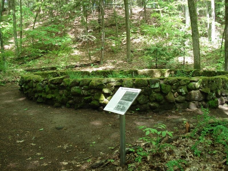
Near Farmington Avenue (Connecticut Route 4) 0.3 miles north of Park Pond Place, on the left when traveling east.
Made of rock and iron, the fountain was the first in the nation powered by electricity at a time when streets and homes were still gaslit. The electricity was generated by the trolley line’s power station using the Farmington River. Colored lights . . . — — Map (db m142561) HM
Located at the west end of Farmington, the village of Unionville was first recognized as
such by the U.S. Postal Service in 1834. Earlier it was called Langdon’s Quarter and
then Union District. Residents took full advantage of the Farmington . . . — — Map (db m134927) HM
On Lovely Street (Connecticut Route 177) at Farmington Avenue ( Route 4), on the right when traveling north on Lovely Street.
In Memory Of
The Men Of Unionville
Who Died For Their Country
First World War
Philip E. Bergin • Ernest W. Gustafson • Louis C. Hanrahan • Harold V. Joyce • Christopher H. Rourke
Second World War
John Garay • Milton Gillespie • Joseph G. . . . — — Map (db m33172) WM
On Farmington Avenue (Connecticut Route 4) north of Walnut Street, on the left when traveling north.
During the week of August 12, 1955, the Farmington Valley was hit by the edge of Hurricane Connie. The area received heavy rainfall that saturated beds of the Farmington River. The following week, Hurricane Diane swept through the Atlantic Coast, . . . — — Map (db m230293) HM
On Farmington Avenue (Connecticut Route 4) at Walnut Street, on the right when traveling south on Farmington Avenue.
Yodkins-Morin Memorial Park
----------
Dedicated to two valiant men who gave their lives
saving others during the raging flood of August 1955
----------
Charles J. Yodkins, Sr
A Farmington Police Officer
----------
Joseph J. Morin, . . . — — Map (db m33063) HM
On Main Street near Hebron Avenue, on the right when traveling north.
Formerly part of Wethersfield, the town was named for Glastonbury in England. Its thirty four original farms, running from the River three miles east “into the wilderness,” were the first officially surveyed by Connecticut Colony, . . . — — Map (db m98863) HM
On Hubbard Street at Green Cemetery Road, on the right when traveling west on Hubbard Street.
Erected in Memory of
Capt. Frederick M. Barber
And the Soldiers of Glastonbury
Who Gave Their Lives for Their Country.
By Mercy Turner Barber.
1918
1861 Civil War 1865
More enduring than this monument will be the memory of their . . . — — Map (db m98832) WM
On Hubbard Street at Main Street, on the right when traveling west on Hubbard Street.
In honor of those who served their
country in the Second World War and in memory of
Charles Galli who was Killed In Action
Herbert Amond · Richard A. Bantle · Everett E. Bantly · Allen F. Behnke · Robert G. Brash · Charles W. Chase, Jr. · . . . — — Map (db m98862) WM
On Hubbard Street at Green Cemetery Road, on the right when traveling west on Hubbard Street.
1917 1919
In Honor of Those of the Town of Glastonbury Who
Answered Their Country’s Call To Serve Humanity
Aborn, Merritt W. · Adams, Charles W. · Ahern, Matthew A. · Antos, Charles F. · Backus, Joseph H. · Barber, George H., M.D. · . . . — — Map (db m98802) WM
On Hubbard Street at Green Cemetery Road, on the right when traveling west on Hubbard Street.
1941 1945
World War II
A tribute to the men and women
who served their country.
In honor of these who gave their lives.
Andrews, Harry E. · Bemer, Steven J. · Boeris, John N. · Carl, Goodrich F. · Chamberlin, Theodore L. · Connell, . . . — — Map (db m98803) WM
On Hubbard Street at Green Cemetery Road, on the right when traveling west on Hubbard Street.
In Honor Of
John Lee Levitow
Glastonbury, Connecticut
Sergeant, United States Air Force
3rd Special Operations Squadron
presented
Congressional Medal of Honor
by
President Richard M. Nixon
May 14, 1970
For conspicuous gallantry . . . — — Map (db m98833) WM
On Main Street at Whapley Road, on the left when traveling south on Main Street.
Kimberly Tract
This land is part of the original grant east of the great river made to John Robbins of Wethersfield in 1640. The original lot of 132 acres – 22 rods wide – extended three miles from the river into the hills. With Eleazar . . . — — Map (db m98902) HM
On Main Street at Morgan Drive, on the right when traveling south on Main Street.
Site of Second Meeting House
First Church of Christ
Congregational
1735 – 1837
News of the battles of Lexington and Concord
reached here while Rev. John Eells was
preaching and was announced from the pulpit
April 28, 1775 . . . — — Map (db m98901) HM
On Salmon Brook Street (Connecticut Route 10) at Meadow Gate Road, on the left when traveling south on Salmon Brook Street.
Settled as the Salmon Brook section of Simsbury early in the 18th century, and established as a separate ecclesiastical society in 1736, Granby became a separate town in 1786. From the beginning, farming was the main endeavor of the populace; . . . — — Map (db m302007) HM
On Salmon Brook Street (Connecticut Route 10) at Elmwood Court, on the left when traveling south on Salmon Brook Street.
Horace B. Clark, Fire Commissioner the City Hartford was the man responsible
for the development of the Lost Acres Fire Department. Mr. Clark had a large estate “Lost Acres” in North Granby from which the name of the present fire . . . — — Map (db m97449) HM
On Salmon Brook Road (U.S. 202) at Hartford Avenue (State Route 189), on the right when traveling north on Salmon Brook Road.
North Side For God and Country Post 182 1985 West Side World War II 1941-1946 Gladwin E Allshouse • Russell F. Cable • Richard J. Creighton, Jr. • Edward P Dombkowski • Ernest D. Evleth • Clifford C. Ferriss, Jr. • John C. Kupruck • . . . — — Map (db m56097) WM
On Salmon Brook Street (U.S. 202) at North Granby Road, on the left when traveling north on Salmon Brook Street.
1917 1918 In Honor of the Men of Granby who served in The World War Andrews, Evelyn S. • Appredries, Charles • Armitage, Harold Raymond • Avery, Paul L. • Boyko, Peter • Bradley, Barnard • Brigham, Storrs T. • Brooks, George • Broughton, Roscoe . . . — — Map (db m56098) HM
On Forrest Street 0.1 miles south of Farmington Avenue, on the right when traveling south.
Daughter of the Reverend Lyman and Roxanna Foote Beecher. Born Litchfield Connecticut 14 June 1811. Married at Cincinnati Ohio 6 January 1836 to Calvin Ellis Stowe. Wrote "Uncle Tom's Cabin" at Brunswick Maine in 1851. Resided in this house . . . — — Map (db m53155) HM
On Farmington Ave. 1 mile Asylum Ave., on the right when traveling east.
On this site, from 1869 until 1963, stood the Hartford Public High School, the second oldest secondary school in the United States. Founded in 1638 as a Latin Grammar School. It became, in 1847, the Hartford Public English and Classical High . . . — — Map (db m28374) HM
The inscribed stone below is the cornerstone of Brownell Hall, which was located on Trinity College's first campus at the present site of the State Capitol in Hartford. Built in 1845 as a dormitory, it was dedicated to the Rt. Rev. Thomas C. . . . — — Map (db m124903) HM
In memory of the Trinity men who fought for the principles in which they believed with the Union and Confederate forces in the Civil War and of those who gave "the last full measure of devotion"
This Gun formed part of the Main Battery of . . . — — Map (db m125008) WM
On Maple Avenue at Campfield Avenue, on the right when traveling north on Maple Avenue.
Griffin A. Stedman
Typical Volunteer Soldier
Of the Civil War
Captain
Major
Lieutenant Colonel
Brigadier General
Born at Hartford Conn., January 6, 1838
Killed at Petersburg, Va. August 5, 1864
[ south side ]
This Monument . . . — — Map (db m52319) HM
Served as secretary to
Admiral Farragut during the
Battle of Mobile Bay
———————————
This Gun
formed part of
the Main Battery of
Admiral Farragut's
Flagship Hartford
during the Civil War
——————
New Orleans • Port Hudson . . . — — Map (db m124916) HM
On Main Street north of Mather Street, on the left when traveling north.
Between 1863 and 1865, nearly 1,700 men of color enlisted in the 29th Volunteer Infantry Regiment, Connecticut's first non-white military unit. The recruits came from a variety of racial and ethnic origins and professional backgrounds. A . . . — — Map (db m230467) HM
On Main Street south of Mahl Avenue, on the right when traveling south.
Reed moved to Hartford in 1916, where she would attend Hartford High School and Hartford Federal College.
She joined WPA's Negro Theatre Project in Hartford in her mid-twenties, and would appear in plays such as "Trilogy in Black," "Porgy," . . . — — Map (db m230471) HM
On Main Street north of Seyms Street, on the right when traveling south.
Johnson came to Hartford in 1916. She and her husband co-owned the only Black-owned funeral services company in the state of Connecticut at the time.
She co-founded the Colored Women's League in 1917 and was its president. Her organization . . . — — Map (db m230466) HM
On Main Street at Mather Street, on the right when traveling north on Main Street.
In 1917, she hosted a small group gathering in her home to co-found the Hartford Branch of the NAACP.
By 1916, Townsend Seymour had already registered to vote and in 1920 went on the campaign trail to run for state representative, the first . . . — — Map (db m230469) HM
On Main Street at Battles Street, on the right when traveling north on Main Street.
Reverend Battles moved to Hartford in 1961, where he would serve as Pastor at Mt. Olive Church and work with Dr. Martin Luther King Jr.
He swiftly rose to become a key figure in Hartford's civil rights movement. He was the Southern Christian . . . — — Map (db m230474) HM
On Main Street 0.1 miles north of Mather Street, on the left when traveling north.
"A place of our common grief, our common hopes and our common faith;
a place wherein we may see and feel our sympathy one with another."
Frederick Law Olmstead
Landscape Architect
Old North Cemetery
On Ford Street at Pearl Street, on the right when traveling south on Ford Street.
The Corning Fountain was commissioned by John J. Corning as a tribute to his father, John B. Corning. It was designed by John Massey Rhind, a noted sculptor born in Scotland.
The fountain's location was chosen as part of a grand entranceway . . . — — Map (db m230328) HM
On Jewell Street west of Trumbull Street, on the right when traveling east.
Dr. Horace Wells was a Hartford Dentist who is credited with the discovery of anesthesia in Hartford in 1844. Wells stated, "let anesthesia be as free as the air we breathe" and did not try to benefit commercially from his discovery. After his . . . — — Map (db m230389) HM
On Trinity Street south of Jewell Street, on the left when traveling north.
Israel Putnam (1718-1790), the legendary general of the French and Indian and Revolutionary Wars, is considered Connecticut's first authentic folk hero. At the outbreak of the Revolutionary War in 1775, at 57 years old, he is famous for riding 18 . . . — — Map (db m230347) HM
On Trinity Street south of Jewell Street, on the right when traveling north.
The City of Hartford commissioned the Soldiers and Sailors Memorial Arch to recognize the 4,000 Hartford residents who served in the Union Army from 1861-1865, including 400 who died during the war. It was designed by George Keller, who also . . . — — Map (db m230367) HM
On Trinity Street at Elm Street, on the right when traveling north on Trinity Street.
Spirit of Victory is a war memorial honoring the Hartford men who fought in the Spanish-American War, 1898-1902. Its creator was Evelyn Longman Batchelder, the first woman sculptor elected as a full member of the Academy of Design, who . . . — — Map (db m230406) HM
On Capital Avenue near Trinity Street, on the left when traveling east.
1st Conn. Heavy Artillery
Originally 4th Conn. Infantry
Mustered in May 22, 1861
Mustered out Sept. 25 1865
Total enrollment officers and men
3802
Erected by the survivors and friends of the regiment and the veteran and active companies . . . — — Map (db m28358) WM
Near Main Street at Central Row, on the right when traveling north.
Adriaen Block
A short distance from
where you are standing,
in 1614
Adriaen Block, captain of the ship Restless
sails up a river from the Atlantic Ocean
which native peoples of the region have named
"Quinnehtukqut", meaning the Great . . . — — Map (db m53151) HM
On Main Street at Arch Street, on the right when traveling north on Main Street.
In memory of the courageous
Adventurers
who inspired and directed by
Thomas Hooker journeyed through the
wilderness from Newtown (Cambridge)
in the Massachusetts Bay to
Suckiaug (Hartford) – October 1635
Mathew Allyn • John . . . — — Map (db m52432) HM
Near Central Row at Main Street, on the right when traveling west.
Alexis de Tocqueville
The 25 year-old French aristocrat and author of
Democracy in America
visited this area
during his 1831 – 1832 tour of America
Tocqueville
C-SPAN
placed by C-SPAN and the cable television industry . . . — — Map (db m52694) HM
On Prospect Street at Bob Steele Street, on the right when traveling south on Prospect Street.
Boxer, motorcyclist, wordsmith, cartoonist and entertainer, Bob Steel joined WTIC (Travelers Insurance Company) in 1936 when it operated from the 6th floor of this Grove Street building. From here until 1961, from Broadcast House in . . . — — Map (db m151923) HM
On Asylum Street east of Union Place, on the right when traveling east.
Reverend Horace Bushnell believed Prosperity was Our Duty and that civic improvement was critical to a prosperous Hartford. As a result of economic decline in the 1840s, Bushnell recognized Hartford's long want of "spacious . . . — — Map (db m230332) HM
On Jewell Street at Trumbull Street, on the right when traveling east on Jewell Street.
Reverend Horace Bushnell believed Prosperity was Our Duty and that civic improvement was critical to a prosperous Hartford. As a result of economic decline in the 1840s, Bushnell recognized Hartford's long want of "spacious . . . — — Map (db m230390) HM
Near Main Street at Gold Street, on the right when traveling south.
[ east side ]
Deming In Memory Of
Capt. Pownal Deming
Son Of
David Deming & Mehitable Champion
Born Sept. 30, 1749
Died April 9, 1795
[ west side ]
An earnest patriot, he enlisted
in the Continental Army at the . . . — — Map (db m44066) HM
Near Main Street at Central Row, on the right when traveling north.
Where you are standing, on October 31, 1687 came Sir Edmund Andros to the meeting house built on this site, sent by the British Crown to revoke Connecticut's Charter and establish the Dominion of New England. Captain Joseph Wadsworth, determined . . . — — Map (db m53150) HM
On Elm Street at Clinton Street, on the right when traveling east on Elm Street.
97 Elm Street
Chapman-Taft House
Erected by Charles & Sarah Chapman
in 1861. Bought in 1873
by Dr. Cincinnatus A. Taft leading
Hartford physician & Mark Twain's
family doctor. Members of the
Taft family resided here
for nearly forty . . . — — Map (db m52258) HM
On Capitol Avenue at Trinity Street, on the right when traveling west on Capitol Avenue.
In Memory Of
Col. Thomas Knowlton
Of Ashford Conn.
Who as a boy served in several campaigns in the French and Indian Wars
Shared in the siege and capture of Havana in 1762
Was in immediate command of Connecticut troops at the Battle of . . . — — Map (db m52189) HM
On Trinity Street at Elm Street, on the right when traveling north on Trinity Street.
ConfuciusConfucius (551 B.C. to 479 B.C.), with the given name Qiu and stylized name Zhongni, was a native of Lu State (now Qufu city of Shandong Province) in the Spring and Autumn Period of Chinese history. He was a great thinker, educator and . . . — — Map (db m52259) HM
Near Main Street at Gold Street, on the right when traveling south.
1771 Memorial 1912
To The Deceased Members Of
The First Company Governor's Foot Guard
Hartford Connecticut
Erected By The
Veteran Corps
Dedicated June 1912
1771
Captain Samuel Wyllys . . . — — Map (db m43772) HM
On Main Street at Gold Street, on the left when traveling north on Main Street.
First speech in Hartford on the grounds of this Church May 18, 1843
"[We found several towns in which people closed their doors and refused to entertain the subject. Notably among those were Hartford, Conn., and Grafton, Mass. . . . — — Map (db m151933) HM
Near Main Street near Central Row, on the right when traveling north.
Where You Are Standing
On September 20, 1780
Waits General George Washington,
Commander-in-Chief of the American Armies
During the American Colonies' Revolution
Against Great Britain.
He has come with Governor Trumbull and . . . — — Map (db m52783) HM
On Main Street at Gold Street, on the right when traveling north on Main Street.
George Washington
was entertained by
Colonel Jeremiah Wadsworth in his home on this site on June 30, 1775 when on his way to Cambridge to assume command of the Army.
On September 21, 22, 23, 1780 with Lafayette, General Knox and Governor . . . — — Map (db m151930) HM
Near Main Street at Gold Street when traveling south.
[ south side ]
George Wyllys
Born 1590 in Fenny Compton Co Warwick England
Came to Hartford 1638
Deputy Governor of Connecticut 1641
And Governor 1642. Died March 9, 1645
Bridget Young his wife died at Fenny Compton
March 1629 . . . — — Map (db m43771) HM
On Main Street at Central Row, on the right when traveling north on Main Street.
To Commemorate The
One Hundred Seventy-Fifth Anniversary
Celebration of the Founding in 1771
Of the First Company
Governor's Foot Guard.
General Jonathan M. Wainwright,
Hero of Corregidor and Guest of Honor
at this celebration was . . . — — Map (db m52913) HM
Near Main Street at Central Row, on the right when traveling north.
To commemorate the
Two Hundreth Anniversary Celebration
Of the First Company Governor's
Foot Guard, founded in 1771.
The oldest military unit in continuous
service in the United States.
Participating were the Centennial
Legion of . . . — — Map (db m52916) HM
On State House Square just east of Main Street, on the left when traveling east.
You are now standing where once stood a structure that was an important piece of Hartford history: The Isle of Safety. An exact outline of this iconic structure has been created on the paved walkway behind you.
When it was erected . . . — — Map (db m151922) HM
Near Main Street at Atheneum Square, on the right when traveling north.
Col. Jeremiah Wadsworth
SAR Branch Connecticut
Erected MCMXIII
Here stood the home of Col. Jeremiah Wadsworth Commissary General of the American forces in the War for Independence and a trusted friend of George Washington and "Brother Jonathan . . . — — Map (db m52427) HM
Near Main Street at Gold Street, on the right when traveling south.
In Memory of the First
Settlers of Hartford
Jeremy Adams • Matthew Allyn • Francis Andrews • William Andrews • John Arnold • Andrew Bacon • John Barnard • Thomas Barnes • Robert Bartlett • John Baysey • Thomas Beale • Nathaniel Bearding • Mary . . . — — Map (db m195603) HM
On Wells Street at Gold Street, on the right when traveling south on Wells Street.
To the Memory of
Jeremy Hoadley
Born at Branford, Conn 1776. Died at Hartford 1847
Selectman twenty four years
Mayor of the City
Judge of the City Court
Representative to the State Legislature
High Sheriff of Hartford County
Erected . . . — — Map (db m249801) HM
Near Main Street near Gold Street, on the right when traveling south.
Of Copford Hall. Essex England. Third Governor of Massachusetts. A founder of this commonwealth & its first Governor. A lover of religious liberty. A man trusted and honored.
Near this place he was buried & by this tablet The Connecticut . . . — — Map (db m44068) HM
Near Main Street near Central Row, on the right when traveling north.
Jonathan Trumbull
Where You Are Standing
From 1768 to 1784
Jonathan Trumbull guides the people of Connecticut
to independence as the colony's Royal Governor.
Governor Trumbull is the only colonial governor
to stand with the patriots . . . — — Map (db m52782) HM
On Central Row west of Market Street, on the right when traveling west.
On Sept. 4, 1824, General Lafayette visited Hartford during his triumphal return to the U.S. He was addressed here by Governor Wolcott. — — Map (db m230408) HM
Near Capitol Avenue at Trinity Street, on the right when traveling west.
Major General
Clarence Ransom Edwards DSM
1859 – 1931
Beloved commander of the 26th Division who led
the sons of New England to glorious victory
on the battlefields of France in the World War
1917 - - - 1918
Sponsored by the . . . — — Map (db m52191) HM
On Main Street near Arch Street, on the right when traveling north.
Mark Twain
Samuel Clemens
1835 - 1910
[ north side ]
One of the nation's most celebrated authors
Mark Twain lived here in Hartford during the peak
of his writing career from 1871 until 1891
Of Hartford, Twain wrote "Of all the . . . — — Map (db m52434) HM
On Central Row at Main Street, on the right when traveling west on Central Row.
Marquis de La Fayette
Where You Are Standing
On September, 1824
Arrives the Marquis de La Fayette in Daniel Wadsworth's carriage drawn by four white horses. Hartford's citizens shout hurrahs, wave banners and throw garlands of flowers at the . . . — — Map (db m43767) HM
Near Main Street (U.S. 44) at Chapel Street South, on the left when traveling north.
On June 5, 1798, Matthew Furlong was shot dead by Crown forces in New Ross as he approached the Three Bullet Gate carrying a flag of truce and a letter asking for the surrender of the town to the Rebel forces.
This monument serves to . . . — — Map (db m151919) HM
On Main Street (U.S. 44) at Chapel Street South, on the left when traveling north on Main Street.
To commemorate the Sister City relationship between the peoples of Hartford, Connecticut and New Ross, County Wexford in the Republic of Ireland.
This relationship promotes economic educational and cultural exchanges; and perpetually fosters . . . — — Map (db m151920) HM
Near Central Row at Main Street, on the right when traveling west.
Old State House
Has been designated a
Registered National
Historic landmark
Under the provisions of the
Historic sites act of August 21, 1935
This site possesses exceptional value
in commemorating and illustrating
the history of . . . — — Map (db m52699) HM
On Asylum Street at Union Place, on the right when traveling east on Asylum Street.
With trains arriving in Hartford and passing the western edge of the Park, Reverend Horace Bushnell wanted to provide an aesthetically pleasing first impression of the City. Bushnell envisioned the Park as an "outdoor parlor", a specialized room in . . . — — Map (db m230325) HM
On Asylum Street at Ford Street, on the right when traveling east on Asylum Street.
Hartford suffered great floods in 1936 and 1938. This resulted in the City and Army Corps of Engineers designing an extensive flood control system that buried the Park River in a tunnel under the Park. In this location, you would have been . . . — — Map (db m230345) HM
On Ford Street at Pearl Street, on the right when traveling south on Ford Street.
The Pearl Street gate was designed by Olmsted Brothers Landscape Architects and added to the Park in the 1940s. The path Leads from the gateway to the Corning Fountain. Donated by John J. Corning in 1898, the fountain was installed in 1899 to honor . . . — — Map (db m230346) HM
Jacob Weidenmann's design of the Park utilized many of Frederick Law Olmsted's techniques, including curvilinear paths and the separation of uses. His design incorporated pedestrian use in the eastern section. Through the design of a carriage path . . . — — Map (db m230349) HM
On Trinity Street south of Jewell Street, on the right when traveling north.
Reverend Horace Bushnell preached Unconscious Influence (1842), the idea that we are "ever touching unconsciously the spring of motion in each other… we overrun the boundaries of personality -- we flow together… by a law of social contagion." . . . — — Map (db m230368) HM
833 entries matched your criteria. Entries 101 through 200 are listed above. ⊲ Previous 100 — Next 100 ⊳