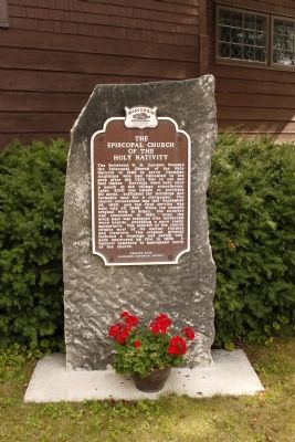
On County Route V 0.2 miles west of County Road A, on the right when traveling west.
The Reverend W. R. Gardner founded the Episcopal Church of the Holy Nativity in 1882 to serve the Canadian Anglicans who had relocated to the area after the Civil War to cut and haul timber. Services were held once a month at the village . . . — — Map (db m59212) HM
A towering elm tree once guided sailing schooners into Jacksonport.
In the mid to late-1800s, three bustling piers were the heart of the community. They connected loggers, farmers, and fishermen to markets in Chicago and Milwaukee. . . . — — Map (db m151581) HM
Near County Road T at Wendt Lane, on the right when traveling north.
On January 18, 1889, Zion Evangelical Lutheran Church was formally incorporated. The congregation consisted mostly of German Lutheran immigrants from the district of Saxon-Weimar-Eisenach who settled in the Jacksonport area. That spring the newly . . . — — Map (db m67017) HM
Near West Wisconsin Bay Road north of Highway 42T, on the right when traveling north.
This steel air funnel is from the iron ore carrier Middleton. This ship was also known as Nashanic, Gulfoil, and Pioneer Challenger. The vessel was built at the Bethlehem Steel Company Shipyard at Sparrows Point, Maryland and . . . — — Map (db m194142) HM
Near West Wisconsin Bay Road north of Highway 42T, on the right when traveling north.
This anchor is from a steamboat from the early 1900's. It was found on the north side of Rock Island in about 20 feet of water. The two-ton anchor was raised in 1979 by members of the Lake County Divers Club and divers from On the Rocks. — — Map (db m194145) HM
Near West Wisconsin Bay Road north of Highway 42T, on the right when traveling north.
This anchor is from the schooner-barge Niagara. On September 7, 1887, the ship was battling a gale off Vermilion Point, on the Michigan coast. She heeled over far enough for her cargo of iron ore to slide up her inside, causing the ship to . . . — — Map (db m194151) HM
The Door Peninsula has been sculpted over time by glaciers, massive sheets of moving ice. As the ice advanced and retreated, lake levels in what would become Lake Michigan fluctuated drastically. You are standing along the former shoreline of . . . — — Map (db m193936) HM
On State Highway 57 south of Pioneer Road, on the right when traveling south.
Welcome to the
Door County Coastal Byway
Discover the true spirit of Door County.
Travel this scenic byway as it loops 66 miles along the Green Bay bluffs and through the dunes and bays of Lake Michigan. Explore lighthouses, nature . . . — — Map (db m229711) HM
Near West Wisconsin Bay Road at Highway 42T, on the left when traveling south.
Fishermen all their lives, Howard and Emery Weborg started fishing with their father Alfred "Skipper" Weborg on his boat the Golden Girl in 1917. After the death of Alfred, their uncle Willy took over the boat until he decided to retire in . . . — — Map (db m194155) HM
You are standing on the edge of the Niagara Escarpment, a bedrock cliff that arcs for almost 1,000 miles from southeastern Wisconsin through northern Michigan and Ontario to central New York. On this side of the Door Peninsula, the escarpment rises . . . — — Map (db m193935) HM
Near North Port des Morts Drive north of State Highway 42, on the right when traveling west.
Porte des Morts, or Death's Door, is the treacherous strait that separates the peninsula from the Grand Traverse Islands. French explorers named it after hearing tales of native warriors who perished in the turbulent waters. The strait . . . — — Map (db m193878) HM
On State Highway 57 south of Pioneer Road, on the right when traveling south.
"Here immigrants from Pomerania, East Prussia converted a stony piece of timber into a beautiful farming community."
- Hjalmar Holand, History of Door County, 1917
The Liberty Grove German Settlement was founded in 1857 by . . . — — Map (db m229709) HM
Near West Wisconsin Bay Road north of Highway 42T, on the right when traveling north.
This early steam-powered windlass (patented August 28, 1855) from the steamer R.J. Hackett represents the evolution from manually powered anchor windlasses to steam powered. To manually raise an anchor from 50 feet of water was not only time . . . — — Map (db m194148) HM
On County Road DK east of County Road N, on the left when traveling east.
What Does the Vandermissen Brickworks Site Represent?
On October 8, 1871, the Peshtigo fire destroyed many of the Belgian farms and small towns along the west side of the Door Peninsula.
The Belgians rebuilt after the fire using bricks . . . — — Map (db m80223) HM
On County Road DK 0.1 miles east of County Road N, on the right when traveling west.
Architecture-History Studies
Section 106 of the National Historic Preservation Act of 1966 (NHPA) requires federal agencies to take into account the effect their projects might have on historic properties such as buildings and landscapes as . . . — — Map (db m145889) HM
On County Road DK east of County Road N, on the left when traveling east.
Wisconsin's and the nation's largest Belgian American settlement is located in portions of Brown, Kewaunee and Door counties adjacent to the waters of Green Bay. Walloon-speaking Belgians settled the region in the 1850s and still constitute a high . . . — — Map (db m12141) HM
On County Road DK east of County Road N, on the left when traveling east.
Early Presence
Jean Nicolet was among the first Europeans to arrive in
Wisconsin, landing on the eastern shore of Green Bay near Red Banks in 1634. He was followed by Claude Allouez in 1639 and Father Louis Hennepin in 1675.
For . . . — — Map (db m80287) HM
On County Road DK 0.1 miles east of County Road N, on the right when traveling west.
Introduction
You are in the Namur Belgian-American National Historic Landmark District, certified in 1900 and the only such District of Wisconsin. This rural landscape appears today much as it did a century ago, and harbors a number of . . . — — Map (db m145892) HM
On County Road DK east of County Road N, on the left when traveling east.
Why Was This Project Undertaken?
WIS 57 is the primary route into and out of the Door Peninsula's popular resort country and by the early 1990s had become inadequate to safely carry current traffic loads.
A Wisconsin . . . — — Map (db m80274) HM
On County Road DK east of County Road N, on the left when traveling east.
The Town of Williamsonville
Tornado Memorial Park in Door County is located on the site of the former settlement of Williamsonville. The town was settled by the Williamson family in 1869 to take advantage of the Door County State Road . . . — — Map (db m80215) HM
On County Road DK east of County Road N, on the left when traveling east.
Historic Preservation and the WIS 57 Project
The National Historic Preservation Act of 1966
(NHPA) requires federal agencies to take into account the effect their projects might have on historic properties . . . — — Map (db m80311) HM
On State Highway 42 at Forest Road, on the right when traveling north on State Highway 42.
Sevastopol orchards thrive in an ideal blend of climate and soils. Lime-rich soils provide essential nutrients for fruit trees. In addition, cool spring temperatures moderated by the waters and ice of Lake Michigan and Green Bay delay blooming. . . . — — Map (db m130498) HM
This stern frame cast iron propeller and steel shaft is believed to be from the lumber steamer Mueller which was built as Edwin S. Tice in 1887 at the Burger yards in Manitowoc, Wisconsin. She measured 159.9 x 32.1 x 12.5; 728 gross tons. The vessel . . . — — Map (db m145895) HM
On State Highway 42 at Forest Road, on the right when traveling north on State Highway 42.
Sevastopol is the heart of Door Peninsula's famous fruit orchards. Swiss immigrant Joseph Zettel planted the first orchard one mile from here in 1862. His State Fair apple exhibit led University of Wisconsin scientists Emmett Golf and Arthur . . . — — Map (db m130496) HM
On South Bay Shore Drive (State Highway 42) 0.1 miles west of Highland Road, on the right when traveling west.
Anne Bonny was born in Ireland, the illegitimate child of a prominent lawyer. This scandal caused her father to leave with his daughter for Charleston, S.C. — — Map (db m275554) HM
On Bay Shore Drive (State Highway 42) 0.1 miles west of Highland Road.
In their final battle with English sailors and marines, Anne Bonny and Mary Read fought off the invaders alone, while Calico Jack and his crew scrambled below deck in fear. — — Map (db m275556) HM
On Bay Shore Drive (State Highway 42) 0.1 miles west of Highland Road, on the right when traveling west.
During the seventeenth and early eighteenth centuries, 2,000 or more buccaneers, from every part of the world, terrorized the Atlantic Coast, from Maine to Florida — — Map (db m275542) HM
On South Bay Shore Drive (State Highway 42) 0.1 miles west of Highland Road, on the right when traveling south.
Blackbeard was giant of a pirate, standing 6'4 and weighing 250 lbs. His flagship was the "Queen Anne's Revenge," which he used to terrorize hundreds of ships on the Atlantic. — — Map (db m275551) HM
On Bay Shore Drive (State Highway 42) 0.1 miles west of Highland Road, on the right when traveling west.
Blackbeard wore a monstrous coal-black beard beginning just under his eyes and covering his face. In battle he wore countless pigtails and tucked smoking fuse cord under his hat. — — Map (db m275553) HM
On Bay Shore Drive (State Highway 42) 0.1 miles west of Highland Road, on the right when traveling west.
Born around 1780 in Bayonne, France, Jean Lafitte and his brother Pierre, moved to the New World in 1810. The two opened a blacksmith shop, used as a cover for smuggling operations. — — Map (db m275570) HM
On South Bay Shore Drive (State Highway 42) 0.1 miles west of Highland Road, on the right when traveling west.
On Jan. 8, 1815, Lafitte fought for General Andrew Jackson at the Battle of New Orleans. Soon after, the lawful American occupation of New Orleans forced Lafitte to retire. — — Map (db m275571) HM
On Bay Shore Drive (State Highway 42) 0.1 miles west of Highland Road, on the right when traveling west.
Henry Every, alias Long Ben Avery, was born in England, and at age 20, was one of the first pirates to operate in the Indian Ocean. — — Map (db m275567) HM
On Bay Shore Drive (State Highway 42) 0.1 miles west of Highland Road, on the right when traveling west.
Ben became well-known throughout the British Isles for his success and wealth as a pirate, once looting the largest pirate treasure ever — worth over $2,000,000 — — Map (db m275568) HM
On Mill Road (State Highway 42) at Bay Shore Drive, on the right when traveling west on Mill Road.
Sister Bay was named For the Sister Islands that Flank its harbor. This pair of small uninhabited islands is a significant nesting site for gulls and terns. The Village of Sister Bay offers the largest public waterfront in Door County for . . . — — Map (db m229455) HM
On Bay Shore Drive (Wisconsin Route 42) at Gateway Drive, on the right when traveling north on Bay Shore Drive.
Built 1866 — Closed 1881
Original location in Appleport area
Areas served: Little Sister Bay,
Sister Bay, Appleport, Rowleys Bay
and Wildwood districts.
First budget $200.00 — First teacher
was H.C. Wilson at $30 per month.
A . . . — — Map (db m229666) HM
On Bay Shore Drive (State Highway 42) 0.1 miles west of Highland Road, on the right when traveling west.
While some pirates flew the flag of another country, as a means of tricking their prey, others took great pride in their colors, often designing the most gruesome flag conceivable. — — Map (db m275543) HM
On North Bay Shore Drive (State Highway 42) close to Mill Road, on the right when traveling north.
Dedicated in memory of the men and women who answered the call and served in the American military forces.
Special honor to those fallen in battle who marched silently past the great captain for final review.
Your deeds will not be forgotten. — — Map (db m200131) WM
On North Bay Shore Drive (State Highway 42) south of Mill Road, on the right when traveling north.
Village life has always revolved around this deep water port.
The community of Sister Bay was born in 1870 when the firm of Henderson, Coon & Dimond built a pier, sawmill, grist mill, hotel, and two stores. They hired Swedish woodchoppers . . . — — Map (db m229453) HM
On Mill Road (State Highway 42) at Mill Road, on the right when traveling west on Mill Road.
Village life has always revolved around this deep water port.
The community of Sister Bay was born in 1870 when the firm of Henderson, Coon & Dimond built a pier, sawmill, grist mill, hotel, and two stores. They hired Swedish woodchoppers . . . — — Map (db m229454) HM
On Bay Shore Drive (Highway 42) 0.1 miles west of Highland Road, on the right when traveling west.
A boisterous minister's son, William Kidd catapulted his way out of the rowdy brotherhood of piracy in 1690 - moving to New York, marrying and establishing himself as a prominent businessman. — — Map (db m275544) HM
On Bay Shore Drive (State Highway 42) near Highland Road, on the right when traveling west.
After sailing 9,000 miles and failing to capture a single ship, Kidd again began plundering many ships of all nations. Kidd was captured in Boston, imprisoned for a year and hung in London. — — Map (db m275548) HM
On Bay Shore Drive (State Highway 42) 0.1 miles west of Highland Road, on the right when traveling west.
Drawn by his thirst for adventure, Kidd returned to England and received a commission to seize French ships. At age 50, Kidd set sail with 150 men. — — Map (db m275546) HM
On West Maple Street at North Kendall Avenue, on the left when traveling east on West Maple Street.
Most popular and widely accepted Christian hymn "The Old Rugged Cross" completed by Rev. George Bennard during Evangelistic meetings here Dec. 29, 1912 - Jan. 12, 1913
First sung as a quartet in the Friends Church Parlors and as a duet at . . . — — Map (db m59215) HM
On North 3rd Avenue at Kentucky Street on North 3rd Avenue.
A modern rendition of Bank of Sturgeon Bay's original tower erected in 1900 on the NW corner of 3rd Ave. & Kentucky St., and removed in 1939. The original bell was reacquired with the cooperation of the First Baptist Church of Sturgeon Bay where it . . . — — Map (db m15722) HM
On Madison Avenue, on the right when traveling north.
The Coast Guard built 207 UTBs, at a cost of $235,000 for each boat, all at the Coast Guard Yard in Curtis Bay, Maryland, from 1973 to 1978. The 41-ft. UTB has been one of the most successful boats in Coast Guard history, ably serving as the . . . — — Map (db m89920) HM
This steel air funnel is from the iron ore carrier Middleton. This ship was also known as Nashanic, Gulfoil, and Pioneer Challenger. The vessel was built at the Bethlehem Steel Company Shipyard at Sparrows Point, . . . — — Map (db m89900) HM
On Madison Avenue at Locust Court, on the right when traveling north on Madison Avenue.
This anchor was recovered in Northern Lake Michigan in 1979 by the crew of the USCG cutter/buoy tender Acacia when that ship was stationed in Sturgeon Bay, Wisconsin. It was assumed that the anchor got fouled in the rocks and could not be . . . — — Map (db m89905) HM
On North 3rd Avenue (County Highway B) near Delaware Street, on the left when traveling north.
This sawmill led to the
founding of Sturgeon Bay
1853
The Founding of Little Lake
Sturgeon Bay's first major settlement was founded in 1853 with the construction of the Bradley-Crandall Sawmill. The original mill was located on a . . . — — Map (db m26859) HM
Sailors have long used floating objects secured to the sea bottom to mark reefs, shoals and other obstructions. Early markers were simply a log or barrel tied to a large rock strategically placed to warn mariners of danger. Over time these markers . . . — — Map (db m145888) HM
These vertical drums revolved on a spindle and were used for generating power required in heaving on a rope or an achor cable.
Donated by Janice D. Turner Pfingsten in memory of Elmer W. Richter, USCG — — Map (db m131461) HM
Born in Tysse, Norway, where steep cliffs and narrow inlets receive the sea, John Roen answered the call to a life of adventure, traveling to the U.S. in 1906. He became a Captain in 1920, and through astute purchases of Great Lakes vessels he . . . — — Map (db m89854) HM
Near Park Drive (County Highway PD) 2.4 miles north of Green Bay Road (State Highway 42 / 57), on the right when traveling north.
Behind you, Government Bluff rises 150 feet above the waters of Sturgeon Bay. It was here that Door County’s first industry began in 1834 — a limestone quarry. Originally intended for a military fort that was never constructed, the stone was . . . — — Map (db m74258) HM
On Madison Avenue north of Larch Street, on the right when traveling north.
This light tower was used by the Coast Guard to mark Dunlap Reef, which is east of the navigation channel and north of the railroad bridge spur. (Bay View Park) in Sturgeon Bay.
Purchased with funds provided by Door County Marine Men's Club — — Map (db m90974) HM
This site marks the Eastern Terminus of the Ice Age National Scenic Trail. The Trail was designated a National Scenic Trail by Congress in 1980 and Wisconsin's first State Scenic Trail in 1987. The Western Terminus is in Interstate State Park on . . . — — Map (db m39249) HM
With a maritime career begun in 1941 at Peterson Boat Works stockroom, Ellsworth attended the USMMA [United States Merchant Marine Academy] Kings Point and sailed on tankers in WWII. He rejoined his family's business, learned the tools of the . . . — — Map (db m89881) HM
Fred started his career in 1908 in his father's boatyard, Peterson Boat Works (PBW), at age 14. After PBW burned in 1918, Fred worked as a shipbuilding supervisor at Leathem Smith Shipyard. A resourceful entrepreneur, he was involved in . . . — — Map (db m89860) HM
George J. "Butch" Baudhuin was a primary force in the pleasure boat industry in Door County. Recognizing Sturgeon Bay's unique location connecting Lake Michigan and Green Bay, he began Baudhuin Yacht Harbor (now Sturgeon Bay Yacht Harbor) in 1944, . . . — — Map (db m89855) HM
On 3rd Avenue at Kentucky Street, on the right when traveling south on 3rd Avenue.
This visually prominent building is a handsome example of the two-part commercial block style common during the period. It originally anchored what was once downtown's principal business corner prior to the completion of the Michigan Street Bridge . . . — — Map (db m89958) HM
On North 3rd Avenue at Kentucky Street on North 3rd Avenue.
The Downtown Historic District includes over forty late 19th and early 20th century commercial, civic and converted buildings. It is located along the three block long heart of Sturgeon Bay's traditional downtown. The District grew as a casual grid . . . — — Map (db m26885) HM
Howard loved the water, sailing and knew all about ships. He was a sailor, shipbuilder, boat launcher, and a long-time DCMM docent. He couldn't wait to sail each spring.
Lou was a great supporter of Howard. She cared for their home, children, . . . — — Map (db m89897) HM
On West Juniper Street near North Lansing Avenue, on the left when traveling east.
Joseph Harris, Sr. recognized as the Father of Sturgeon Bay Ship Canal, was born in London, England in 1813 and emigrated to the United States in 1849. Coming to Door County in 1855, he became involved in real estate. He built the first brick . . . — — Map (db m191568) HM
On Columbia Avenue north of Green Bay Road ( Highway 42/57), on the right when traveling north.
Caring - Compassionate - Loving
Co-Founder of Overland Bolling Company
Committed and devoted to his Customers and Employees
Remembered for his warm friendly smile
Lived his life by these simple words
You Reap What You Sow"
"Be The Best . . . — — Map (db m89827) HM
United States Coast Guard Radio Tower
Karl Overland
Co-Founder of Overland Bolling Company
Founded in 1956
Lived his life by these simple words
"You Reap What You Sow"
"Be The Best That You Can Be
In This Land of . . . — — Map (db m89884) HM
Near Bay Shore Drive (County Highway B) 0.4 miles north of Bay Shore Heights Drive, on the left when traveling north.
John Leathem and Thomas Smith established this dolomite quarry at the mouth of Sturgeon Bay in 1893. Though they produced dimension stone for building harbors around Lake Michigan, Leathem and Smith's quarry became a major operation by capitalizing . . . — — Map (db m39345) HM
This lifeboat was part of the safety equipment aboard the Edwin H. Gott, a 1,004-foot self-unloading bulk freighter, when it was built and launched from the Bay Shipbuilding Company in Sturgeon Bay in 1979. (Bay Shipbuilding is located just to . . . — — Map (db m258734) HM
For many centuries, mariners have traversed the Great Lakes to deliver passengers and cargo, to gather fish, and to enjoy the splendid waters. This plaque is dedicated to those who lost their lives in this great water wilderness: the commercial . . . — — Map (db m89853) HM
On 3rd Avenue south of Michigan Street, on the right when traveling south.
The Henry S. Baird Masonic Lodge was initially established in 1878 and was housed in a number of locations around downtown [illegible] 50 years before establishing a permanent home at this location. The building was designed by local architect . . . — — Map (db m89962) HM
On State Highway 57 0.1 miles east of Mathey Road.
The Farm Forty (SW 1/4 of NW 1/4 Section 26 Township 28 North, Range 26 East) was part of the first commercial orchard in Door County. In 1895, this orchard of 77 acres was the largest in Wisconsin. Joseph Zettel, a Swiss immigrant who arrived in . . . — — Map (db m289818) HM
On Madison Avenue north of Larch Street, on the right when traveling north.
This cast iron propeller and stirrup bearing unit is from the Steamer Wotum, which was built in 1893. This historic ship was 190 feet long, had a 36-foot beam, and weighed 936 gross tons. A steam engine was installed about 1910 - fore and . . . — — Map (db m90975) HM
These two propellers were removed from the John Purves during her renovation in 2007 and wrapped with rope for display.
They were originally installed in 1957 when the vessel was converted from steam to diesel power at the Sturgeon Bay . . . — — Map (db m89886) HM
On Michigan Street west of North 4th Avenue, on the right when traveling west.
This building was built as a library through a $12,500 Carnegie Foundation grant to the Sturgeon Bay Library Association. It was designed by local architect Fred D. Crandall and served the Sturgeon Bay community until 1974 when a new library was . . . — — Map (db m191571) HM
Bob Peterson lived on the water, worked on the water and played on the water. In 1939 he officially joined Peterson Builders Inc., the shipyard started by his father, Fred. After several military deferments, he enlisted in the army and served as . . . — — Map (db m89858) HM
In the early 1850's Robert Laurie and his family immigrated to the United States from Glasgow, Scotland. They bought land north of the village of Sturgeon Bay in an area now known as Sevastopol. Mr. Laurie, a sailor and shipbuilder by trade, found . . . — — Map (db m89852) HM
The schooner was found off Bailey's Harbor in Door County, Wisconsin. The rudder was brought up from Lake Michigan by Century Divers of Lake County, Illinois. It is estimated to be from about 1827. — — Map (db m131469) HM
On Madison Avenue north of Locust Court, on the right when traveling north.
This plaque is given by the State of Wisconsin Department of Veterans Affairs in grateful recognition of the United States Coast Guard, for its long and storied history of steadfast service in Wisconsin. On the mighty Mississippi River, the . . . — — Map (db m89903) HM WM
Much of the history of the City of Sturgeon Bay has been shaped by the comings and goings of all manner of ships and boats. The marine propeller played an important role as these vessels transitioned from sail to steam as their primary means of . . . — — Map (db m131476) HM
Mounted on the stern of the ship over the rudder, the double wheel was used to steer the ship in the event of a breakdown of the regular steering system. The two wheels provided space for additional "man" power.
Donated by John and Robert Purves . . . — — Map (db m131467) HM
Resting 150 yards off shore from here is the wreckage of the steam barge Joys, a vessel once hailed as a “greyhound among lumber carriers” for her record-breaking speed. The Joys was constructed in 1884 in the Milwaukee Ship Yard Company. She hauled . . . — — Map (db m43400) HM
On Madison Avenue north of Larch Street, on the right when traveling north.
This engine is from the Mercury (length 250.8, beam 43.01), which was built by the Pennsylvania Shipyard of Beaumont, Texas. She was launched in June 1937 for Tankers, Inc. before moving to Lakeland Tankers Ltd., its Canadian subsidiary in . . . — — Map (db m90979) HM
Near Canal Road east of Buffalo Ridge Road, on the right when traveling east.
This canal was the dream of Joseph Harris, Sr., "the Father of the Sturgeon Bay and Lake Michigan Ship Canal." His intent was not only to provide a shorter and safer route for sailing vessels, but to also become rich by selling building lots along . . . — — Map (db m15196) HM
On Madison Avenue at Sturgeon Bay, on the right when traveling north on Madison Avenue.
This property is listed in the
National Register
of Historic Places
by the United States
Department of the Interior
and the
Citizens For Our Bridge
organization
Opened July 4, 1931 . . . — — Map (db m90978) HM
When Sturgeon Bay was settled in the 1850's a boat was needed to cross the bay except in winter when people and teams of horses or oxen could cross over the ice. Ferry service was established beginning in 1860, using rowed or winch pulled ferries . . . — — Map (db m131478) HM
Completion of this waterborne shortcut between Green Bay and Lake Michigan in 1878 is arguably the most important event in the maritime history of the City of Sturgeon Bay and the Door Peninsula as a whole. Officially titled "The Sturgeon Bay and . . . — — Map (db m131489) HM
An essential element to safe maritime travel has long been visual navigational aids such as buoys and lighthouses. Collectively, this system of markers and beacons is known as Aids to Navigation - or AtoN for short. The five Great Lakes alone . . . — — Map (db m131506) HM
Prior to merging with the City of Sturgeon Bay in 1891, the west side of the bay was known as Sawyer. Despite being absorbed into Sturgeon Bay, the west side continued to be called Sawyer for many years and many landmarks bear the Sawyer name, . . . — — Map (db m145896) HM
Revenue Marine and Coast Guard vessels, known as "cutters," have been frequent visitors to the port of Sturgeon Bay for decades. The Door Peninsula's many lighthouses also made Sturgeon Bay a frequent port-of-call for U.S. Lighthouse Service tenders . . . — — Map (db m167608) HM
For over 140 years, the City of Sturgeon Bay has enjoyed a long and productive relationship with the United States Coast Guard and its predecessor services. In 1873 the Lighthouse Establishment began setting buoys to mark the treacherous Dunlap Reef . . . — — Map (db m167609) HM
From the earliest days of humans putting to sea in ships, there has been a need to "anchor" a vessel to the bottom. The first anchors were simply large stones. However, the need for a lighter, more efficient securing device quickly became essential. . . . — — Map (db m131502) HM
In pioneer times, private boats and commercial ferries were used to cross the waters of Sturgeon Bay. In 1887 the crossing became considerable [sic] easier when John D. Leathem and Thomas H. Smith completed a toll bridge consisting of a wooden plank . . . — — Map (db m43677) HM
On State Highway 42 near Maple Heights Circle (unmarked private farm road).
In 1858 Joseph Zettel, a native of Switzerland, acquired the farm directly south of this Station and established the first commercial orchard on the Door Peninsula. The high yields and quality of his fruit aroused the interest of Emmett S. Goff of . . . — — Map (db m5190) HM
Established by Door County in November 1927.
Through trial and tribulation, in poverty and loneliness, in cold and fire, the pioneers struggled that their children might gain a competence.
Here was the Village of Williamsonville with a . . . — — Map (db m268769) HM
Near Canal Road east of Buffalo Ridge Road, on the right when traveling east.
This monument is an intrusive igneous red granite rock — the official rock of the State of Wisconsin. It was quarried near Wausau, Wisconsin, and specifically known as "Wisconsin Ruby Red." It was crystallized from magma about 1750 million . . . — — Map (db m15205) HM
On State Highway 57 at Dunn Road, on the right when traveling south on State Highway 57.
John Wester, an early German pioneer, built the saloon in 1895. Mail was brought by stagecoach and handled by owners until 1906 when rural delivery was inaugurated. In 1905, John Moore added on the large hall. By 1912, during the Joseph Petersilka . . . — — Map (db m307270) HM
How do you lose your anchor?
A violent storm can break the anchor chain causing the ship to crash onto shore. Other times, anchors get hung up on the lake bottom, when sailors can't break them loose, they are abandoned.
The stock . . . — — Map (db m254119) HM
Imagine the size of the tree that this wood piece was cut from!
This mass of timber, called deadwood, was placed at the ship's bow, just after the stem post, It provided rigidity and strength, reducing damage when the ship collided with . . . — — Map (db m254109) HM
373 entries matched your criteria. Entries 101 through 200 are listed above. ⊲ Previous 100 — Next 100 ⊳