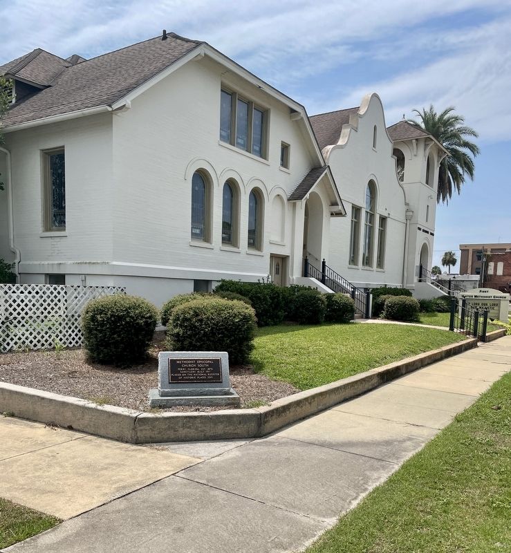
Methodist Episcopal
Church South
Perry, Florida, Est. 1870
Sanctuary Built 1917
Placed on the National Register
of Historic Places 2015 — — Map (db m230040) HM
The Perry Army Air Base of World War II stood in an 862 acre area south and west of this point.
The 441st and 312th Fighter Squadrons of the Third Army Air Force trained replacement pilots for combat units worldwide.
The 338th Fighter . . . — — Map (db m17717) HM
Taylor County was created from Madison County on December 23, 1856. It was named for Zachary Taylor, 12th president of the United States and commander of U.S. Army forces in Florida during part of the Second Seminole War. The name of the county seat . . . — — Map (db m167493) HM
Taylor County's 50-mile coastline and shallow coastal waters made it ideal for manufacturing salt for the Confederacy. By 1862 works were in operation in Jonesville (now Adam's Beach) and near the mouth of Blue Creek. Trading on the barter basis, . . . — — Map (db m163121) HM
Dedicated To All Veterans Whose
Valor, Blood, Sweat And Tears
Triumphed Over Tyranny
Let us not forget the sacrifice
that millions of service men and
women made for our country
and our freedom
We may never know all . . . — — Map (db m231101) WM
This park is
dedicated in
memory of all
Veterans who
served honorably
in the Armed
Forces of the
United States
of America
Taylor County Board of Commissioners
Patricia Patterson Chairwoman • Daryll T. Gunter Vice Chair • . . . — — Map (db m229887) WM
On August 7, 1964 The U.S. Congress passes the Gulf of Tonkin Resolution, giving President Lyndon Johnson the power to take whatever actions he sees necessary to defend Southeast Asia. This set the stage for America's Longest war, eventually . . . — — Map (db m230031) HM WM
Vietnam veterans were 9.7% of their generation. 8,744,000 GI's were on active duty during the war.
3,403,100 personnel served in the SEA theater, (Vietnam Cambodia, Laos, flight crews in Thailand and sailors in adjacent South China sea waters.) . . . — — Map (db m229953) HM WM
3,403,000 veterans served in the Vietnam theater. Of those who died, 86.3% were Caucasian, 12.5% were Black, 1.2% were other races. Two thirds of those who served in Vietnam were volunteers. 77% of the combat deaths were volunteers. 17,579 married . . . — — Map (db m230026) WM
The Persian Gulf War of 1991 was fought between Iraq and a coalition of 39 countries. The United States government called the war "Operation Desert Storm”. The coalition had formed after Iraq invaded Kuwait on Aug. 2, 1990. On November 29, 1990, The . . . — — Map (db m229913) HM WM
April 6, 1917 U.S. President Woodrow Wilson declared war upon Germany. To such a task we can dedicate our lives and our fortunes, everything that we are and everything that we have, with the pride of those who know that the day has come when America . . . — — Map (db m230007) HM WM
World War I involved more countries and caused greater destruction than any other war except World War II. An assassin's (Gavrilo Princip) bullets which killed Archduke Franz Ferdinand sparked the outbreak of World War I, and a system of military . . . — — Map (db m230011) HM WM
The World at War, the name commonly given to the global conflict of 1939-1945. It was the greatest and most destructive war in history. Whereas military operations in World War I were conducted primarily on the European continent, World War II . . . — — Map (db m230016) HM WM
This war started on September 1, 1939 when Germany under the command of dictator Adolf Hitler invaded
Poland. The United States did not enter the war until Japan attacked military bases at Pearl Harbor in Hawaii December 7, 1941. Germany, Italy, . . . — — Map (db m230018) HM WM
Established on December 23, 1856, Taylor County honors Zachary Taylor, the 12th U.S. President and celebrated General during the Second Seminole War. His leadership throughout Florida during the Second Seminole War made settlement in the young . . . — — Map (db m309139) HM
Robert M. Hendry moved from Georgia and purchased farmland in the Shady Grove area in 1852. Reverend Henry, a Methodist Circuit Rider in Florida and Georgia, served as the pastor of Friendship Church in Madison County. In 1872, members of the . . . — — Map (db m110897) HM
Located at the mouth of the Steinhatchee River, Deadman Bay was on Spanish maps by the early 1500s. Spanish Conquistador Panfilo de Narvaez came through the area in 1529 followed by Hernando de Soto ten years later. DeSoto crossed the Steinhatchee . . . — — Map (db m67599) HM
In 1892, fire destroyed the first Wakulla County courthouse. Two years later, George Washington Tully and Thomas McGlynn completed this courthouse using native heart pine material. Located in the center of the town plat, this wood frame building . . . — — Map (db m210284) HM
Constructed in 1948, the Old Wakulla County Jail is a concrete and stucco building in the Art Deco style. The architect was James A. Stripling and builder was the S.J. Curry Company, who also constructed the nearby Wakulla County Courthouse. From . . . — — Map (db m209986) HM
It’s October 11, 1539…
Hernando de Soto and his army have stopped for the winter at the village of Anhayca, just north of here. Low on supplies, De Soto has dispatched his trusted Captain, Juan de Añasco…
As we are desperate for . . . — — Map (db m126593) HM
Two miles north of this site was located the town of Magnolia, founded in 1827 by the four Hamlin brothers of Augusta, Maine. The Hamlin family had been attracted to the new territory of Florida by the availability of land. The Hamlins chose a site . . . — — Map (db m167166) HM
(side 1)
This recreational trail follows the alignment of the historic Tallahassee-St. Marks Railroad, the first Florida railroad chartered by the territorial government in 1831.
See back for more information
(side . . . — — Map (db m125493) HM
Side 1
On March 11, 1968, a Special Permit for the use of this property in the St. Marks Wildlife Refuge was issued to the Florida Board of Parks and Historic Memorials by the United States Department of the Interior.
These organizations . . . — — Map (db m167169) HM
Constructed in 1924 and accredited in 1928, this was the first high school built in Wakulla County. The original stucco section, an "H"shaped design with one central area and three classrooms on each side, was made possible when Sopchoppy citizens . . . — — Map (db m101143) HM
(front side)
In 1936 J. T. "Bo" Lynn founded Bo Lynn's Grocery market to serve the community of St. Marks. A wide variety of goods, including groceries, clothing, gasoline, automotive and boat parts, and fishing supplies were made . . . — — Map (db m117216) HM
On July 30, 1944, thirteen B-17s from the 325th Bomber Squadron left Avon Park Army Airfield on a routine mock-bombing exercise over Tallahassee and Waycross, Georgia. Severe thunderstorms near Tallahassee caused the formation to separate as . . . — — Map (db m186512) HM
Fort San Marcos de Apalache has been designated a Registered National Historic Landmark Under the provisions of the Historic Sites Act of August 21, 1935 this site possesses exceptional value in commemorating or illustrating the history of . . . — — Map (db m186477) HM
Here are interred the remains of 19 soldiers of the 4th and 7th Regiments of the United States Infantry and the 4th Battalion of the United States Artillery. These men were members of the garrison of 200 stationed here during the United States . . . — — Map (db m67114) HM
The former town of Port Leon, once the terminal for the Tallahassee-St. Marks Railroad, was located across the St. Marks River about two miles south of here.
Reverse:
Port Leon, A Ghost Town Two Miles South
1838-1843 . . . — — Map (db m67270) HM
In 1838, a small town was founded below the confluence of the Wakulla and St. Marks rivers and the ports of St. Marks and Magnolia. Promoters of Port Leon boasted of its high elevation and the prosperity to come from the Tallahassee Railroad. . . . — — Map (db m257798) HM
Port Leon, located three miles south of St. Marks on Apalachee Bay, was founded in 1838 and incorporated in 1841. It was developed by and became the terminus of the Tallahassee Railroad Company. It was a prosperous port for a few years and was the . . . — — Map (db m129386) HM
In Grateful Remembrance
for a heroic and humanitarian act of courage in saving the life of an American soldier in March, 1818
Princess Malee "Milly" Francis
(c 1803 – 1848)
Woman of the Creek (Seminole) Indian Nation, recipient, . . . — — Map (db m116505) HM
This is the site of the original Spanish fortifications. The first fort was a flimsy wooden fort started in 1678 and completed in 1679. The second fort, also of wood was built in 1718 on this site. A hurricane flooded this fort in 1758 and forty men . . . — — Map (db m67115) HM
Wooden stockades were built here by the Spanish in 1680 an 1758. In 1758, these were destroyed by a hurricane which drowned the garrison. A masonry fort was begun in 1759 but was soon abandoned to the Indians for a trading post and Indian . . . — — Map (db m67113) HM
In 1837 the Tallahassee-St. Marks Railroad was open for regular business operations. In 1983 the railroad was closed, after 146 years of operation. The following year, the Florida Department of Transportation purchased 16 miles of the corridor and . . . — — Map (db m186409) HM
Noted lighthouse builder Winslow Lewis began work on the Saint Marks structure in 1829. Eroding shores forced relocation a short distance inland in 1842 to its present location. The adjoining keeper’s house is not original having been rebuilt on . . . — — Map (db m67106) HM
It’s October 16, 1539…
In searching this area for a usable harbor, Hernando de Soto’s captain Juan de Anasco has found evidence of Pánfilo de Narváez’ expedition of 1528…
In an overgrown clearing, we have discovered many horse skulls and . . . — — Map (db m126594) HM
This 1800's sketch shows early development around Fort San Marcos de Apalachee at the confluence of the St. Marks and Wakulla Rivers. In 1833, the citizens left this swampy land and moved inland. Today, St. Marks is one of the oldest settlements . . . — — Map (db m186445) HM
[front side] St. Marks was the only settlement along this coast at the time of the American Revolution and became economically important after the war. In 1784, Panton, Leslie & Company set up a store along the west bank of the Wakulla . . . — — Map (db m172510) HM
On January 23, 1995, a vestige of Florida's ancient past emerged from the soil at Wakulla Springs State Park. During an archaeological investigation prior to a construction project, state archaeologist Calvin Jones uncovered a rare Paleolndian . . . — — Map (db m152898) HM
Creek Devastation
By 1813 a tragic civil war between Lower Creeks and Upper Creeks (Red Sticks) at
Horseshoe Bend (Alabama) brought famine to the Red Sticks. Their leader was Hillis Hadjo, or Prophet Josiah Francis. He followed a prophetic . . . — — Map (db m255205) HM
Industrialist, naturalist, conservationist, who for forty years preserved and maintained the amenities of Wakulla Springs in their natural state, thus establishing a heritage for the preservation of these resources for the continued enjoyment and . . . — — Map (db m152899) HM
North of Spanish Florida's boundary with the United States, Creek Indian ranchers John and William Kennard supported the U.S. government's mandated westernization program of Creek Indians.
Before Spain sold Florida to the U.S. in 1819, the U.S. . . . — — Map (db m255204) HM
This location is significant as it represents relationships between human culture and natural resources from the settlement systems of the Paleoindian period to the recent historic past, a period of nearly 15,000 years. There are 55 recorded . . . — — Map (db m101862) HM
152 entries matched your criteria. Entries 101 through 152 are listed above. ⊲ Previous 100