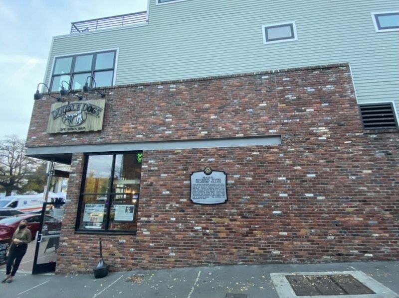
On #802 Alley at 21st Avenue S (Tennessee Highway 106), on the right when traveling east on #802 Alley.
Owen and Harold Bradley operated a one-story,
concrete block film and recording studio located
behind this Hillsboro Village storefront from
1953-1955. "Queen of Country Music” Kitty Wells, bluegrass legends Bill Monroe and the Stanley . . . — — Map (db m163031) HM
On Fairfax Avenue at 25th Avenue South, on the right when traveling west on Fairfax Avenue.
Elizabeth Rhodes Atchison, born in Nashville on Feb. 26, 1858, married prominent banker John H. Eakin in 1882. Active in many civic causes, in 1917 she became the first woman to join the Nashville City School Board. After her death in 1936, a new . . . — — Map (db m147450) HM
On West End Avenue at Acklen Park Drive, on the right when traveling east on West End Avenue. Reported permanently removed.
The Nashville Medical Society, the first medical association in Tennessee, was founded March 5, 1821, by 7 physicians in the log courthouse on the Public Square. Pres. was Dr. Felix Robertson, first white child born in Nashville. Chartered Sept. 4, . . . — — Map (db m55018) HM
On 33rd Avenue at West End Avenue (U.S. 70S), on the right when traveling south on 33rd Avenue.
The Nashville Medical Society, the first medical association in Tennessee, was founded March 5, 1821, by seven physicians in the log courthouse on the Public Square. The first president was Dr. Felix Robertson (1781-1865), son of James and Charlotte . . . — — Map (db m147479) HM
On Acklen Avenue east of Belmonat Boulevard, on the left when traveling east.
This mansion was built in 1853 as a summer home for Joseph and Adelicia Acklen. An 1860 addition by architect Adolphus Heiman expanded the mansion's size to 36 rooms. The entrance to the 177 acre estate, which featured gardens decorated with marble . . . — — Map (db m52143) HM
On Belmont Boulevard at Beechwood Avenue, on the right when traveling north on Belmont Boulevard.
When Adelicia Acklen's estate was sold in 1890, the Belmont Mansion and its ground became Belmont College. Other portions, and parts of the neighboring Sunnyside Mansion property, were subdivided into residential lots by the Belmont Land Co. In . . . — — Map (db m52304) HM
Ten yds. north stood toll gate and toll gate house erected by Nashville and Hillsboro Turnpike Co., Incorporated in 1848. Charges to travel macadamized road could not exceed: horse or mule, 3 cents; 10 sheep, 20 cents; 20 meat cattle, 25 cents; . . . — — Map (db m81454) HM
On Belmont Blvd south of Clayton Avenue, on the left when traveling south.
After success in Memphis with Sun Records, "Cowboy" Jack Clement founded Jack Clement Recording Studios in 1969, producing and writing for artists such as Johnny Cash and Charley Pride. It was the first facility of its kind in Nashville, with . . . — — Map (db m76355) HM
June 1922, Boy Scout John H. DeWitt, Jr., started Nashville's first radio station (WDAA) on the Ward-Belmont Campus. Assisted by music teacher G. S. deLuca, he broadcast Enrico Caruso records to the opening of the River and Rail Terminal on the . . . — — Map (db m52306) HM
On 12th Avenue South just south of Ashwood Avenue, on the right when traveling south.
School Desegregation in Nashville "Nashville Plan" Schools
In Brown v. Topeka (1954) and Brown II (1955)
the U.S. Supreme Court ordered public schools
nationwide to end racial segregation "with all
deliberate speed.” Nashville . . . — — Map (db m169073) HM
On White Bridge Pike 0.1 miles east of Post Road, on the right when traveling north.
The deadliest train wreck in US history occurred on July 9, 1918, when two crowded trains collided head-on at Dutchman’s Curve. The impact caused passenger cars to derail into surrounding cornfields, and fires broke out throughout the wreckage. Over . . . — — Map (db m52596) HM
On Fatherland Street just east of South 5th Street, on the right when traveling east.
The portion of East Nashville known as Edgefield, the name suggested by Gov. Neill S. Brown, was incorporated as a city Jan. 2, 1869. Its approximate bounds were Shelby Ave., Sevier St., So. 10th St., Berry St., Cowan Ave. and the river. It's first . . . — — Map (db m147721) HM
On Woodland Street east of South 6th Street, on the right when traveling east.
After union successes to the north in TN and KY, Col. John Kennett, 4th Ohio Vol. Cavalry, ordered Cpt. H.C. Rodgers to Edgefield. They jet with Nashville Mayor R.B. Cheatham, Feb. 23, 1862, at the Edgefield home of the banker Charles Fuller, to . . . — — Map (db m145784) HM
On Jefferson Street, on the left when traveling east.
Born Potsdam, Prussia. Came to Nashville 1838. Lived in home on this site. Architect, Engineer & Builder; Designed Univ. of Nash. Main Bldg., Central State Hosp. Main Bldg., Suspension Bridge over Cumberland River. Masonic Leader; Adj. U.S. Army . . . — — Map (db m4512) HM
On Charlotte Pike (U.S. 70) at Buffalo Road, on the right when traveling west on Charlotte Pike.
The original Newsom's Mill was located upstream & was destroyed by flood in 1808. Joseph M. Newsom constructed this turbine-powered gristmill in 1862 of hand-dressed limestone cut from Newsom's quarry, a mile south. Newsom's stone is found in many . . . — — Map (db m147423) HM
On Travelers Ridge Drive at Granny White Pike, in the median on Travelers Ridge Drive.
Grave of Lucinda "Granny" White, who settled here in 1803 on 50 acres of land. She died in 1815 at about age 73. Granny White Tavern stood 200' to the north. Famous for its food, brandy, and comfortable beds, it attracted travelers from the Natchez . . . — — Map (db m95832) HM
The Temple Cemetery was established in 1851 with the purchase of three acres by the Hebrew Benevolent Burial Association and still serves Nashville's first Jewish congregation, The Temple, Congregation Ohabal Sholom. It blends early urban burial . . . — — Map (db m74332) HM
On Holly Street just east of South 16th Street, on the right when traveling east.
Holly Street Fire Hall.
Completed in 1914, J.B. Richardson Engine Company No. 14 was designed by Nashville's first city architect, James B. Yeaman. Designed to blend in with the surrounding residential neighborhood, it was the first fire hall . . . — — Map (db m147720) HM
On North 17th Street at Woodland Street, on the right when traveling north on North 17th Street.
Located 250 yds. S.E., this famous pioneer spring served Lockeland mansion on site of present school building. Home built by Col. Robert Weakley in early 1800's and named for his wife, daughter of Gen. Matthew Locke of Salisbury, N.C. Spring water . . . — — Map (db m147717) HM
On McEwen Avenue just east of Rudolph Avenue, on the left when traveling east.
An activist for LGBT rights and advocate for people with mental health and housing issues, Campbell co-organized Tennessee's delegation to the 1987 March on Washington for Lesbian & Gay Rights and Nashville's 1988 Pride parade at a time when many . . . — — Map (db m147716) HM
On East Marthona Road 0.2 miles south of West Old Hickory Blvd (Tennessee Route 45), on the right when traveling south.
Clarence Eugene “Hank” Snow purchased this Madison home with his wife Minnien in 1950, not long after his appearance on the Grand Ole Opry. He was one of the first musicians in the United States to build and use a home studio. Snow’s band, the . . . — — Map (db m234768) HM
On Tanglewood Drive 0.1 miles west of Brush Hill Road, on the right when traveling west.
The Tanglewood Historic District is a rustic style suburban development from the 1920-1940s built by Robert M. Condra, a prominent Nashville builder. Natural materials are featured in this popular Arts and Crafts substyle that harmonizes with the . . . — — Map (db m147709) HM
On Buena Vista Pike 0.1 miles south of Beals Lane, on the right when traveling south.
Lt. Alexander Ewing was commissioned in the Continental Army in Sept. 1777 and promoted to Capt. in 1781. That year, while serving as aide-de-camp to Maj. Gen. Greene, he was wounded at Guilford Courthouse. Ewing moved to Davidson Co. c. 1786 and . . . — — Map (db m147789) HM
On Harding Place, on the left when traveling east.
On Dec. 16, 1864, Gen. S.D. Lee's Corps, Army of Tennessee, held this right flank of Hood's defense line which ran south along the crest of this ridge. Violent artillery fire and infantry attacks by the corps of Wood and Steedman failed to dislodge . . . — — Map (db m25651) HM
On Granny White Pike at Battery Lane, on the right when traveling north on Granny White Pike.
Josephine Groves Holloway
1898-1988
Josephine Holloway graduated from Fisk Univ. with a degree in sociology in 1923. She worked at Bethlehem Center as a case worker, where she began organizing the first African-American Girl Scouts troops . . . — — Map (db m147410) HM
On Benton Avenue just east of 8th Avenue South (U.S. 31), on the left when traveling east.
About 100 yards east stood Waverly, the home of A.W. Putnam, a writer and historian. The house was named for the Waverley Novels by Sir Walter Scott. Putnam sold Waverly in 1858, and in 1887 the land was conveyed to a real estate syndicate — the . . . — — Map (db m147528) HM
On Elm Hill Pike at Briley Parkway (Tennessee Highway 155), on the right when traveling west on Elm Hill Pike.
The Mud Tavern Community developed around the crossroads of the Elm Hill and McGavock Turnpikes. The name derives from the mud and log inn at the crossroads where early 19th century travelers found rest and refreshment. Mud Tavern later became a . . . — — Map (db m147567) HM
On Rosa L. Parks Boulevard (Alternate U.S. 41) 0.2 miles Athens Way, on the right when traveling west.
Brick manufacturer and builder, who fought under General Andrew Jackson in the Creek campaigns and at the Battle of New Orleans, left at his death in 1880 property and $100,000 as an endowment for a school later called Watkins Institute, organized . . . — — Map (db m147768) HM
On Vantage Way at Great Circle Road, in the median on Vantage Way.
The Nashville Race Course, the "Burns Island Track," 1828-1884, was .6 of a mile north. Here Oct. 10, 1843, was run the then richest race in the world, the $35,000 Peyton Stakes, 4 mile heats, promoted by Bailie Peyton. The winner owned by Thomas . . . — — Map (db m147769) HM
On Music Square East at Music Circle North, on the right when traveling north on Music Square East.
BMI (Broadcast Music, Inc.), an organization that collects performance royalties for songwriters and music publishers in all genres of music, opened its doors in New York in 1940. BMI was the first performance rights organization to represent what . . . — — Map (db m60229) HM
On 19th Avenue South south of Scaritt Place, on the right when traveling south.
Library and archives of the 19th c. American religious unity movement which became: the Christian Church (Disciples of Christ); Christian Churches; and Churches of Christ. Located here, 1958, in the Thomas W. Phillips Memorial. Architects: Hoffman & . . . — — Map (db m52367) HM
On 25th Avenue South, on the right when traveling south.
Marvin T. Duncan, a graduate of Webb School (Bell Buckle) and Vanderbilt University, founded Duncan School in 1908 at this site on 25th Avenue S. He and his wife, Pauline, taught at the school until it closed in 1952. The Duncans dedicated their . . . — — Map (db m52171) HM
On 25th Avenue North just south of Parman Place, on the right when traveling north.
In 1968, Hospital Corporation of America (HCA) was founded by Dr. Thomas Frist Sr., his son Dr. Thomas Frist Jr. and businessman Jack C. Massey. The original office was located here, in a small house near HCA's first hospital - Park View. At the . . . — — Map (db m147456) HM
Near 25th Avenue North, on the right when traveling south.
Chief Engr. Army of Tenn. C.S.A.; Construction Engineer on first R.R. Bridge in Nashville; City Engineer of Nashville and Member of American Society of civil Engineers; Director of Works at the Tennessee Centennial Exposition, 1897 & Co-Founder of . . . — — Map (db m4142) HM
On Division Street at Buddy Killen Circle, on the right when traveling east on Division Street.
The heart of Nashville's music business, Music Row began in 1955, when Owen Bradley opened the Quonset Hut, the first recording studio here. In 1957, Chet Atkins opened RCA's studio at the corner of 17th and Hawkins. Other studios, . . . — — Map (db m147532) HM
On 23rd Avenue North at Brandau Place, on the right when traveling south on 23rd Avenue North.
The Nashville Medical Society, the first medical association in Tennessee, was founded March 5, 1821, by 7 physicians in the log courthouse on the Public Square. Pres. was Dr. Felix Robertson, first white child born in Nashville. Chartered Sept. 4, . . . — — Map (db m4522) HM
On Charlotte Avenue (U.S. 70) just west of 19th Avenue North, on the left when traveling west.
In 1815, T.M. Burland opened a small brewery 1.5 miles west of Nashville along Cockrill Spring. The brewery used water from the nearby spring and barley purchased from local farmers. J.T. and W.B. Smith operated the brewery from 1834 until it was . . . — — Map (db m313838) HM
These wheels used by the Confederacy to grind gunpowder at Augusta, Ga in 1863-1864 were made in Woolwich, England and were shipped on the blockade runner "Spray," via Mobile. After the war Gen. Miles purchased them for use at Sycamore Powder Mills, . . . — — Map (db m4144) HM
On Music Square West at Roy Acuff Place, on the left when traveling south on Music Square West.
RCA Records established a recording studio in this building in Novemeber 1957, with local offices run by guitarist-producer Chet Atkins. Its success led to a larger studio, known as Studio A, built next door in 1964. Studio B recorded numerous hits . . . — — Map (db m81463) HM
On April 11, 1898, at the request of Nashville Bishop Thomas Byrne, the Daughters of Charity opened St. Thomas Hospital on this site in the former home of Judge J.M. Dickinson. Named for Byrne's patron saint, the hospital began as a 26-bed "refuge . . . — — Map (db m81464) HM
On 19th Avenue South north of Scarritt Place, on the right when traveling north.
Established in Kansas City in 1892 by the Methodist Episcopal Church South and moved to Nashville in 1924, Scarritt trained laity in Christian education, music, and missions until it closed in 1988. Much of the Collegiate Gothic campus architecture . . . — — Map (db m60196) HM
On West End Avenue (U.S. 70S) at 29th Avenue North, on the right when traveling east on West End Avenue.
On Dec. 17, 1891, the Tenn. legislature granted a charter establishing the Old Woman's Home "for the care and protection of aged and helpless women." In 1909, the women moved from 136 Cherry St. (4th Ave) to a new home at 2817 West End Ave. Later . . . — — Map (db m147454) HM
On Elliston Place just north of Louise Avenue, on the left when traveling north.
One of Nashville's oldest streets, Elliston Place was a popular commercial corridor by 1930. Elliston Place Soda Shop opened in 1939. In 1971 Owsley Manier and Brugh Reynolds
opened the listening-room style music venue Exit/In, named for its main . . . — — Map (db m158328) HM
On June 7, 1976, 101 permanent representatives of the United Nations made a historic and unprecedented group visit to Nashville at the invitation of Tennessee Governor Ray Blanton and Nashville Mayor Richard Fulton. During the visit, the United . . . — — Map (db m4141) HM
On Edgehill Avenue west of 19th Avenue South, on the right when traveling west.
Founded in 1915 as the successor to The Winthrop Model School at the University of Nashville, Peabody Demonstration School was established at this site in 1925 to utilize the teacher training methods developed at George Peabody College for Teachers. . . . — — Map (db m52366) HM
On West End Avenue (U.S. 70), on the left when traveling east.
To prepare young men for College & for life, believing the first object of education to develop character, the second to develop intellect, third to make Christian gentlemen, Wallace University School, directed by Professor Clarence B. Wallace, . . . — — Map (db m25067) HM
On 25th Avenue North just south of Park Plaza, on the right when traveling south.
Centennial Park was the site of May Day rallies held annually from 1914 until 1920, when the Tennessee General Assembly ratified the 19th Amendment to the U.S. Constitution, guaranteeing the right to vote to American women. Suffragists marched from . . . — — Map (db m147457) HM
On Briley Parkway (Tennessee Route 155) at Vultee Boulevard, on the right when traveling north on Briley Parkway.
In 1844, noted educator, evangelist, and agriculturalist Tolbert Fanning started Franklin College, a liberal arts school near this site where boys farmed to cover tuition. In 1855 he co-founded the Gospel Advocate, a religious journal. Fanning's . . . — — Map (db m147559) HM
On Edmondson Pike 0.1 miles south of Mount Pisgah Road, on the right when traveling north.
In 1867, Jane Watson deeded land to several African-American families, many of them her former slaves. First called Watson Town, the community became known as Mt. Pisgah by 1871. The Methodist Episcopal Church North organized a church here in 1866 . . . — — Map (db m147087) HM
On 16th Avenue South just south of Grand Avenue, on the right when traveling north.
Belmont Church and Koinonia Coffeehouse
Koinonia (Greek for 'fellowship') Coffeehouse opened in 1973 with artists such as Dogwood, Fireworks and Brown Bannister boldly sharing their faith through contemporary music. It became a destination . . . — — Map (db m147530) HM
On South Street east of Music Square East, in the median.
Established during and after the Civil War, Edgehill became a vibrant African American neighborhood in the 20th century, drawing residents through its schools, churches and thriving local economy. Edgehill was home to leaders in government, . . . — — Map (db m160770) HM
On Charles E. Davis Boulevard at Fain Street, on the right when traveling north on Charles E. Davis Boulevard.
Constructed in 1892 for Hose Company #1, this building is one of the earliest extant fire halls in Nashville. The upstairs housed firefighters while the lower floor stabled the company's two horses. R. C. Burk served as the first Captain. The fire . . . — — Map (db m147544) HM
On Nashboro Boulevard 0.2 miles east of Murfreesboro Pike (U.S. 41), on the right when traveling west.
Built in the 1830s, rebuilt in 1859, and expanded in 1880, Perry Dale Sr. and Alberta G. Dale purchased this two-story frame house in 1946, naming it GranDale. The one-story wings were added to each side in the 1970s. Between 1972 and 1973, Perry . . . — — Map (db m147403) HM
On State Highway 100 just east of McCory Lane, on the left when traveling east.
In 1951, Lon and Annie Loveless began serving fried chicken, biscuits and jams at picnic tables to hungry travelers from Highway 100, then the main road between Nashville and Memphis. They soon converted their 4-room home into a restaurant, added . . . — — Map (db m312175) HM
On Third Avenue North at James Robertson Parkway (U.S. 431), on the left when traveling north on Third Avenue North.
Music publishing in Nashville began in 1824 when "The Western Harmony" was published by Allen D. Carden and Samuel J. Rogers. A book of hymns and instruction for singing, it was printed by Carey A. Harris on the press of his newspaper, the Nashville . . . — — Map (db m147736) HM
On Dr. Martin Luther King Jr. Boulevard at 4th Avenue North, on the right when traveling east on Dr. Martin Luther King Jr. Boulevard.
Freedman's Savings and Trust Company Bank. In March 1865, Congress established the Freedman's Savings and Trust Company Bank. A Nashville branch was chartered in Dec. 1865. By 1867, there were 37 branches, mostly in the South. Liberty Hall was . . . — — Map (db m145781) HM
On 2nd Avenue North 0.1 miles north of James Roberston Parkway (U.S. 431), on the right when traveling north.
Sam Houston, a native of Virginia, moved to Nashville in 1818 to study law with Judge James Trimble. Admitted to the bar later that year, Houston practiced in Lebanon, Tenn., before returning to Nashville to serve as District Attorney (1819-21). In . . . — — Map (db m147738) HM
The Nashville Gas Light Co., founded Mar. 1850, with General Washington Barrow, President, built first gas works in Tennessee for manufacturing gas from coal. First street lamp was lighted Feb. 13, 1851 at Second Ave. North and Public Square. . . . — — Map (db m74334) HM
On Monroe Street at 10th Avenue N, on the left when traveling west on Monroe Street.
Built in 1915 with a grant from Andrew
Carnegie, this Beaux Arts style
building with a classical portico and
limestone trim was Nashville's second
public Carnegie library. Designed by
architect C. K. Colley, it has served
generations in North . . . — — Map (db m315181) HM
On Cass Street 0.1 miles west of 10th Avenue North, on the right when traveling west.
Located at 1100 Clay Street, North Nashville High School opened in 1940. Designed by Hart and Russell, the building was constructed with funding from the Public Works Administration, and featured carved stone panels by sculptor Puryear Mims. The . . . — — Map (db m147766) HM
On Dominican Drive at Athens Way, on the right when traveling east on Dominican Drive.
The name Saint Cecilia, patroness of music was chosen for a grammar and high school for girls, opened in October 1860 by four Sisters who had moved to this site from Saint Mary's Convent, Third Order of Saint Dominic, Somerset, Ohio on August 17, . . . — — Map (db m4098) HM
On Ashland City Highway (Tennessee Route 12) 0.1 miles east of Eatons Creek Road, on the right when traveling west.
Here was toll-gate No.2 of the Hyde's Ferry Turnpike Co., chartered in 1848 to build a road from Nashville to Ashland City and Sycamore Mills. Richard Hyde's ferry crossed the Cumberland 2.6 mi. southeast, where the railroad bridge is now. Davidson . . . — — Map (db m147791) HM
On Granny White Pike at Richland Woods Lane/Club Drive, on the right when traveling south on Granny White Pike.
During the retreat from Nashville, Colonel Edmund Rucker's brigade attempted to block the Union pursuit by erecting a barricade of fence rails and logs across Granny White Pike, 1/2 mile south of this spot. During the ensuing night attack by Union . . . — — Map (db m60230) HM
On 6th Avenue South at Lafayette Street, on the right when traveling south on 6th Avenue South.
This building, renowned for its pure Gothic architecture and harmony of proportions, was designed by Wills & Dudley of New York, in a style suggesting an English village church. The cornerstone was laid May 7, 1852, by Bishop James Otey. The church . . . — — Map (db m81455) HM
On 6th Avenue South just north of Mulberry Street, on the right when traveling north.
The Nashville Brewery was founded by Jacob Stiefel on this location in 1859. After the Civil War, the brewery had various owners until it was rebuilt by Christian Moerlein and William Gerst in 1890. Renamed the William Gerst Brewing Co in 1893, it . . . — — Map (db m147506) HM
On Nolensville Pike (Alternate U.S. 31) at McClellan Avenue, on the right when traveling south on Nolensville Pike.
Two blocks west, on the hill, stood Radnor, a college for young women. Founded by A.N. Eshman in 1906, it gained national attention for its complimentary educational tours for students. After the school closed in 1914, a printing plant on campus . . . — — Map (db m147127) HM
On West End Avenue (U.S. 70S) at Four-Forty Parkway (Interstate 440), on the right when traveling west on West End Avenue.
At 8:07 p.m. on Sunday, March 16, 1958 a bomb exploded at the Jewish Community Center at 3500 West End Avenue. The JCC, which was located here from 1952-84, often hosted community meetings aimed at desegregating Nashville's schools and communities . . . — — Map (db m147443) HM
On Bowling Avenue at Richland Avenue, in the median on Bowling Avenue.
This early planned subdivision presents a largely unaltered picture of suburban residences in early 20th century Nashville. With ninety percent of existing homes built between 1905 and 1925, the styles range from large American four-squares to the . . . — — Map (db m53381) HM
On Westbrook Avenue east of Meadowbrook Avenue, on the right when traveling west.
This Federal-style home was built c1810 for John Brown Craighead and his first wife Jane Erwin Dickinson. Craighead was the son of early Nashville settler the Rev. Thomas Craighead. In 1823, Craighead married Lavinia Robertson Beck, youngest . . . — — Map (db m53382) HM
On Lock 2 Road 0.3 miles north of Cain Harbor Drive, on the right when traveling north.
In 1888, the U.S. Army Corps of Engineers sought to make water travel on the Cumberland River easier by regulating water levels with a series of dams and locks. Construction on Lock 2 began in 1892, and the lock and dam were finished in 1907. The . . . — — Map (db m154919) HM
On Middleton Street just west of Academy Place, on the right when traveling east.
Opened on this site February 1890, with a capacity of 60 beds. Doctor Charles Brower of the University of Nashville Medical Department was appointed Superintendent. In 1891 a school of nursing was opened with Miss Charlotte E. Perkins as . . . — — Map (db m147536) HM
On Hermitage Avenue (U.S. 70) just east of Academy Place, on the right when traveling west.
The city's present waterworks was inaugurated at this site Oct. 1, 1833. The pumping station was erected on the lower river bluff & the reservoir on the upper grounds. German engr., Albert Stein, designed and supervised construction. The system cost . . . — — Map (db m147534) HM
On 2nd Avenue South just north of Lea Avenue, on the right when traveling north.
On this site stood the residence of Captain Thomas Green Ryman, owner of the Ryman steamboat line and builder of the Union Gospel Tabernacle, renamed Ryman Auditorium after his death in 1904. The Queen Anne frame house with a slate roof, seven . . . — — Map (db m147537) HM
On Hermitage Avenue (U.S. 70) at Middleton Street, on the right when traveling east on Hermitage Avenue.
The city's first fire-fighting force of volunteers was formed in May 1807. The first paid Dept. was organized on July 29, 1860, with J.S. Dashiell as chief. Three horse-drawn steam engines were bought. A telegraph alarm was installed in 1875. Chief . . . — — Map (db m147535) HM
On 4th Avenue South just south of Lea Avenue, on the left when traveling south.
Nettie Langston Napier had a Day Home Club on this site by 1907. It provided childcare, meals, education and healthcare for the children of poor, working African American mothers. Napier appointed a vice president for each of the city's wards, each . . . — — Map (db m147505) HM
On 5th Avenue North south of Garfield Street, on the left when traveling south.
Fehr School. Named for local merchant and former school board member Rudolph Fehr, and designed by architects Dougherty and Gardner, Fehr School opened in 1924. On Sept. 9, 1957, Fehr became one of the first schools in Nashville to . . . — — Map (db m269542) HM
On Ashland City Highway (Tennessee Route 12) at Old Hickory Boulevard, on the right when traveling west on Ashland City Highway.
Bells Bend
Bells Bend, first known as White's Bend, is an 18-square-mile area encompassed by a U-shaped bend in the Cumberland River. Numerous archaeological sites indicate that the area has been inhabited for at least 10,000 years. Bells . . . — — Map (db m191958) HM
President Rutherford B. Hayes laid its cornerstone in 1877. Designed by Treasury Department architect W.A. Potter, it was occupied in 1882 by collectors of customs and internal revenue, U.S. courts, and Nashville's main post office. Addition to rear . . . — — Map (db m147164) HM
On Broadway 0.1 miles east of 7th Avenue South, on the right when traveling east.
Organized in 1820, this is the church's third downtown location. The elaborate Gothic tower is all that remains of the Matthews & Thompson building that stood at this location from 1886 to 1967. The Baptist Sunday School Board, now one of the . . . — — Map (db m24141) HM
On Demonbreun Street at 6th Avenue South, on the right when traveling west on Demonbreun Street.
The Holy Trinity Greek Orthodox Church was established on Nov. 4, 1917, at 208 6th Ave S., the former site of Wallace Univ. School. Greek immigrants began moving to Nashville in the 1880s in search of better economic opportunities. In 1905 a . . . — — Map (db m147533) HM
On 8th Avenue South (Tennessee Route 6) at Palmer Place, on the right when traveling south on 8th Avenue South.
Site of a farm implement factory operated by Messrs. Sharp and Hamilton, previous to the War Between the States. With the outbreak of hostilities they reversed the Biblical injunction and produced swords of excellent quality for the Confederacy. . . . — — Map (db m74348) HM
On 9th Avenue South at Demonbreun Street, on the right when traveling north on 9th Avenue South.
Located immediately south, this fashionable place of entertainment was established by Messrs. Decker & Dyer in 1827 and operated for more than a decade. It covered several acres & included a ballroom, dining hall and miniature railroad. Pres. . . . — — Map (db m61661) HM
On Rains Avenue at Merritt Avenue, on the right when traveling south on Rains Avenue.
On Christmas Day 1779, John Rains led his family and livestock across the frozen Cumberland and settled in this vicinity. In 1784 he built a fort that enclosed this hill and the spring 75 yards east. At James Robertson's orders he often led a . . . — — Map (db m147540) HM
On Rains Avenue just south of Southgate Avenue, on the right when traveling south.
Founded in 1915 as the first public high school in the county system, Central High School stood here from 1921-1971. One of the earliest student government associations in the South began here. Many graduates became city and county political . . . — — Map (db m147122) HM
On Wedgewood Avenue at Wilson Drive, on the right when traveling east on Wedgewood Avenue. Reported missing.
The Cumberland Fair and Racing Association sponsored harness racing here 1891-1894. The great match race between Hal Pointer of Tennessee and Direct of California occurred Oct. 21, 1891. Direct won all 3 heats in record time for a pacing race. . . . — — Map (db m147120) HM
On December 13, 1850, the Tennessee No. 1, the first steam engine ordered by the Nashville & Chattanooga Railroad, arrived from Cincinnati at the Nashville wharf on the steamboat Beauty. The one-mile trip from the wharf to the crossing . . . — — Map (db m74361) HM
On Ft. Negley Boulevard 0 miles north of Chestnut Street, on the right when traveling north.
The guns of Fort Negley, commanding three turnpikes to the South & Southeast, opened the Battle of Nashville, Dec. 15, 1864. This site was selected by Capt. J. S. Morton as the key strongpoint in the Federal line around the city. The European style . . . — — Map (db m30054) HM
On Chestnut Street just east of Martin Street, on the right when traveling east.
In 1897, Jacob May and his family moved to Nashville and opened the Rock City Hosiery Mill. May obtained a contract to use convict labor for his mill, located inside the state penitentiary on Church Street. In 1908, May incorporated the company . . . — — Map (db m147539) HM
On Old Glenrose Avenue just east of Dodge Drive, on the left when traveling east.
Mill Creek Baptist Church, mother church of Southern Baptists in Davidson County, occupied two meeting houses at this site from 1797 until the early 20th century. Here, in 1833, Baptists formed the first Tennessee Baptist Convention. The church's . . . — — Map (db m147169) HM
On Lafayette Street (U.S. 70S) at Claiborne Street, on the right when traveling north on Lafayette Street.
James C. Napier (1845-1940), Nashville Negro lawyer, educator, member of the city council, delegate to four Republican conventions, Register of U.S. Treasury, 1911-15, was a trustee of Fisk, Howard, and Meharry, advocate of the public schools, and . . . — — Map (db m147545) HM
On Air Freight Boulevard at Vultee Boulevard, on the right when traveling north on Air Freight Boulevard.
In 1858 P. & N. Harsh built a small brewery near Franklin College on Stones River Pike. E.D. Crossman & M.J. Drucker took over in 1860, renaming it the Tennessee Brewery. After fire destroyed it in 1860 and again in 1864, Drucker rebuilt it as . . . — — Map (db m249146) HM
On Park Avenue just east of 49th Avenue North, on the right when traveling east.
Cohn School
Designed by architects Asmus and Clark and opened in 1928 as a junior high school, Cohn
School was named in memory of Corinne Lieberman Cohn, one of the first female
members of the school board. Jonas H. Sikes served as first . . . — — Map (db m147440) HM
On 46th Avenue North at Murphy Road, on the right when traveling south on 46th Avenue North.
In 1927 the City of Nashville bought 131 acres from Warren Sloan and made this the city airport, named for Lieut. Brower McConnell, Tennessee National Guard pilot who died that year in an air crash. Aircraft outgrew the field in the 1930s and moved . . . — — Map (db m147168) HM
In 1927 the City bought 131 acres
from Warren Sloan and made this the
Nashville airport, named for Lieut.
Brower McConnell, Tennessee National
Guard pilot who died that year
in an air crash. The hangars were
50 yards east. Aircraft outgrew . . . — — Map (db m166471) HM
On Charlotte Avenue (U.S. 70) just east of 49th Avenue North, on the right when traveling east.
Once a part of the Byrd Douglas plantation, the Nashville Land Improvement Company dedicated ten acres for a public park in 1887. After annexation, the park became a Nashville City Park in 1907, and the City added playground equipment. Richland Perk . . . — — Map (db m147439) HM
On Charlotte Pike (U.S. 70) just west of 51st Avenue North, on the left when traveling west.
St. Ann Catholic Church and School opened here in 1921. Two Sisters of Charity first welcomed West Nashville Catholics at gatherings held above a nearby hardware store in 1917. This informal gathering became St. Peter's Mission, thanks to support of . . . — — Map (db m180446) HM
On 48th Avenue North at Utah Avenue, on the left when traveling north on 48th Avenue North.
A two-room frame school building was constructed here in 1907 to serve the children of newly-annexed West Nashville. Students in grades 1-8 attended here, and a second two-room building was added in 1909 for students in grades 1-4. Maria Wilson Hill . . . — — Map (db m147442) HM
On Cleveland Street just west of North 3rd Street, on the left when traveling west.
Glenn School. Named for Davidson County Judge and former Edgefield mayor William A. Glenn (1805-1883), the two-story, brick Glenn School opened in 1904. On Sept. 9. 1957, three African American first grade students desegregated the school. An . . . — — Map (db m163412) HM
On his bluff in 1780, pioneers who came with James Robertson built Heaton's (also spelled Eaton's) station. It and two other forts (Nashborough and Freeland's) withstood all Indian attacks and saved the Cumberland settlements. On the river below . . . — — Map (db m74331) HM WM
On Lischey Avenue just south of Gatewood Avenue, on the left when traveling south.
In 1882, T.S. and T.C. Joy, founders of Joy & Son floral co. (est. 1877), bought 91 acres east of Lischey Ave. for their greenhouse operations, including the Gen. White home and White-Ogden Cemetery. The Joys built a large greenhouse (1886) and two . . . — — Map (db m147762) HM