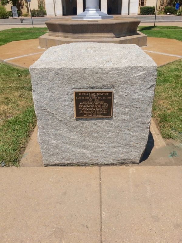
In honor of
Major Charles L. Kelly, MSC, U.S. Army
1925 - 1964
Dust-Off Pilot Extraordinary
Killed in action by small arms fire
while attempting to approach a hot LZ
near Vinh Long, Viet Nam on 1 July 1964
after . . . — — Map (db m96555) WM
"It is for us the living, rather, to
be dedicated here...
to the great task remaining
before us...
that from these honored dead we
take increased devotion to that
cause for which they gave the last
full measure of devotion, . . . — — Map (db m75613) WM
In honor of
1Lt Sharon A. Lane, ANC, U.S. Army
1943 - 1969
FAMC Staff Nurse, 1968 - 1969
Killed by enemy mortar round while
serving with honor
312th Evac Hospital, Chu Lai, Viet Nam
Only ANC Officer to die as a result . . . — — Map (db m96560) WM
1917 1918
In Memory
of the
Officers Nurses
and Enlisted Men
of the
Medical Department
United States Army
Who Lost Their Lives
During the
World War
This Tablet is Erected
by their Coworkers of
the Medical Department . . . — — Map (db m96553) WM
The Rocky Mountains proved a formidable barrier to early aviation, leaving Colorado in a familiar position: bypassed. As with the railroads fifty years earlier, transcontinental air traffic went through Wyoming; Colorado had to make do with a . . . — — Map (db m70525) HM
By Denny Haskew National Sculptor’s Guild City of Brighton Colorado May 2002 The night before an important event the tribe would gather around the pow wow circle chanting. The members of the Society of the Sacred Arrow would rush into the center of . . . — — Map (db m289392) HM
This boarding house was built in 1908 by the Reinhardt family. A pear tree grew thru the front porch leading the Brighton community to calling it the “Tree House.” Phil and Jeanette Daily purchased the house in 1967. In 2010, the house was . . . — — Map (db m289393) HM
Historic City Hall was initially built as the first permanent Adams County Courthouse. The courthouse was designed in 1904 by architect John James Huddart, who also designed the Brighton Armory. In 1906, builder A.B. McDonald completed the . . . — — Map (db m203311) HM
In honor of
1Lt John Harold Buckley (1896-1918)
Longmont, Colorado
Lost his life in World War I,
on a mission behind German lines.
Buckley Field 1942-1947
Denver Naval Air Station
1947-1959
Buckley Air National Guard Base . . . — — Map (db m75593) HM WM
Early Years of Statehood
In the early years of statehood, silver strikes at Leadville and Aspen brought settlers and money into Colorado. Rail lines, smelters, and refineries were built, and large coalfields were opened up.
The High . . . — — Map (db m119387) HM
This farmhouse is the only one still standing on the Refuge, where 200 families once lived. Rose and Gottlieb Egli raised eight children in
this house. — — Map (db m255718) HM
Rocky Mountain Arsenal National Wildlife Refuge
Located just eleven miles northeast of downtown Denver, the Refuge is the largest contiguous open space in the Denver metropolitan area. A major environmental restoration program will be . . . — — Map (db m119390) HM
This Headquarters area is dedicated in honor of all the Rocky Mountain Arsenal employees who accomplished the production, demilitarization, and environmental restoration at the Arsenal from 1942 until 2012 — — Map (db m162066) HM WM
As the focus changed to environmental cleanup, Building 111 became the headquarters of this new mission-and of a public-private partnership among the U.S. Army, Shell Oil Co. and U.S. Fish and Wildlife Service. Years of
Partnership Called . . . — — Map (db m163885) HM
Arsenal Beginnings
Building 111, also known as the “White House, "was located north of the flagpole area. The building was the U.S. Army's headquarters
from the time the Arsenal was established in 1942 until the building was . . . — — Map (db m163883) HM
In 1942, women and men of the U.S. Army built this Arsenal that helped achieve victory in WWII and the Cold War. With thanks to our partners, the U.S. Army, Shell Oil Company and their contractors, we dedicate this flagpole to the employees of . . . — — Map (db m119380) HM
Above this sign, a mile away, 230 buildings once stood. The U.S. Army constructed South Plants in 1942 to produce chemical weapons for World War II — — Map (db m156147) HM
The Fourteeners
There are 58 peaks in the Colorado Rocky Mountains that are above 14,000 feet in height. While 54 are generally acknowledged to be "14ers", most people who want to climb them want to climb all 58. They are contained in six . . . — — Map (db m119395) HM
Commerce City
Commerce City was incorporated as Commerce Town in 1952 and became Commerce City in 1970. In 2004 the Prairie Gateway, a 917-acre parcel of land located along the western edge of the Rocky Mountain Arsenal National Wildlife . . . — — Map (db m119381) HM
Dedicated Veterans Day 2003 Artist: Hai Ying Wu
Veterans and the American Flag symbolize our nation's strength and unity, and continue to be a source of pride and inspiration for millions of Americans.
This Memorial serves to honor and . . . — — Map (db m202817) WM
Ma Barker's infamous son, Lloyd "Red" Barker traded in a life of crime for a life in Westminster in the 1940s. Lloyd grew up as part of the Barker Gang, described by FBI Director J. Edgar Hoover as "the toughest gang of hoodlums the FBI has ever . . . — — Map (db m69547) HM
The value of one's life can be measured by how he or she has added value to the lives of others. In 2003 this statue was dedicated to those who gave freely of their time to serve Westminster Citizens through the fire service and community activities. — — Map (db m4648) HM
High-Five Plains Towns
Watkins, Bennett, Strasburg, Byers, Peoria, Deer Trail, Agate, Godfrey, Cedar Point, Riverbend—most of these Colorado high plains towns were founded around the time when the Kansas Pacific Railroad arrived in . . . — — Map (db m70522) HM
This bell was purchased in 1926 by the Fireman’s auxiliary and the town for $140. The 40 inch bell weighs 1100 pounds. It was used to summon the volunteer firemen until 1950 when a siren was installed. It was on the water tower until 2012 and . . . — — Map (db m257631) HM
Alfred Packer was born on January 21, 1842, in Allegheny County, Pennsylvania. He served in the Union Army during the Civil War and was discharged in June 1863 for epilepsy. Packer traveled to the Rockies and worked for the mines for 9 years. In . . . — — Map (db m182105) HM
In the early part of the 20th century, Denver served as both the state capital and the Arapahoe County seat. An amendment to the Colorado Constitution creating a new City and County of Denver was passed by Colorado voters in 1902. This left . . . — — Map (db m130140) HM
A duplicate casting of the bronze plaque on the front of this monument was dedicated in Bega, New South Wales, Australia by the Littleton Delegation on April 22, 1986 through the generous contributions of
P.W. Anderson • Arapahoe Sertoma Club • . . . — — Map (db m289469) HM
The first railroad to reach present-day Littleton was the Denver & Rio Grande on October 28, 1871. The line was being built by William Jackson Palmer to connect Denver to the resort community he had just founded, Colorado Springs. Richard Little's . . . — — Map (db m177545) HM
These gentlemen have fostered international understanding since 1954. Through their inspiration, regular social and cultural exchanges maintain a lasting friendship between Bega, New South Wales, Australia and Littleton, Colorado, USA. Hundreds of . . . — — Map (db m289467) HM
One of the earliest buildings in Littleton was the J. D. Hill General Store. Julius D. Hill, known as J.D., was born in Massachusetts in 1843 and served in the Union Army during the Civil War. Hill came to Littleton in 1870 and was employed by the . . . — — Map (db m177629) HM
This memorial is dedicated to the millions of men and women of the United States who served their country during World War II. The cause was freedom. Their actions and sacrifices will always be remembered. November 11, 2000
American Theater of War . . . — — Map (db m46114) HM
The Main Street Historic District preserves the unique mix of historic buildings in Downtown Littleton that remind us of Littleton’s evolution from an agricultural settlement to a town and eventually to the city we enjoy today. In 2004, downtown . . . — — Map (db m289593) HM
The evolution of mass transit in Denver has resembled a cross-town commute — a long stop-and-go journey. It began in 1871, when the Denver Horse Railroad Company started running horse-drawn coaches over tracks laid in the middle of downtown’s dirt . . . — — Map (db m177560) HM
At various points in its history, the Rough and Ready Mill churned out flour, lumber, and livestock feed. But the end product was always the same: growth for Littleton. Built in 1867 by pioneers Richard Little, Joseph Bowles, and John Lilley, among . . . — — Map (db m177558) HM
Colorado CannibalAside from his conviction for cannibalism, Alfred Packer was a fairly commonplace frontier character: He came West to find his fortune but found trouble instead. Packer, like most, brought his woes upon himself. A . . . — — Map (db m177559) HM
In 1951 the US Information Agency made a documentary film of a rural newspaper in smalltown America to promote freedom of the press. This 20-minute black-and-white film, "Small Town Editor," featured the Littleton Independent and it's editor G. . . . — — Map (db m289466) HM
Historic Town Hall stands in the middle of Littleton’s four-block Main Street and provides the focal point of its downtown area. A bond issue was approved in April 1919 to fund the project at 2450 West Main Street. It replaced the town hall . . . — — Map (db m289299) HM
The Weston Lodge Number 22 of the Ancient Free and Accepted Masons was organized in Littleton in 1872. It was named for Allyn Weston, a Harvard graduate who had published a Masonic magazine in Detroit before moving to Colorado in 1860 to practice . . . — — Map (db m177636) HM
Erected by Union Pacific Railroad in commemoration of Comanche Crossing Centennial
Marking point where rails were joined to form the first continuous land link by railroad across the U.S. — — Map (db m107232) HM
A continuous chain of rails, from the Atlantic to the Pacific had long been a vision of pioneer railroaders and frontier tamers. It became a reality at 3:00 pm on August 15, 1870 at a point 928 feet east of railroad milepost 602, near Comanche . . . — — Map (db m87596) HM
A continuous chain of rails from Atlantic to Pacific -- long a vision of pioneer railroaders and frontier-tamers -- became reality at 3:00 P.M. on August 15, 1870. At a point 3,812 ft. east of the depot in what now is Strasburg, Colorado. Near . . . — — Map (db m17596) HM
(Left Panel)
Climbing -- A Longtime Boulder Passion
Scrambling, tramping, hiking, climbing, mountaineering...No matter the name, early Colorado Chautauquans reveled in their outings into the adjacent foothills. In 1908, . . . — — Map (db m88253) HM
The fountain was erected in 1936 by the Boulder Lions Club. Its smooth terra cotta cladding and strong vertical lines complement the 1933 Art Deco Style courthouse. The courthouse and fountain were designed by local architect Glen H. Huntington. . . . — — Map (db m87600) HM
Fourscore and seven years ago our fathers brought forth on this continent a new nation, conceived in liberty, and dedicated to the proposition that all men are created equal. Now we are engaged in a great Civil War, testing whether that nation, . . . — — Map (db m87645) HM
This sign marks the site of The Holiday Drive-In, which operated from 1953 until 1988. Drive-In theaters were popular in the 1950s and 1960s, especially among young families and amorous couples, where films could be viewed from the relative . . . — — Map (db m18299) HM
This building was the site of a continuously operated dry goods store from 1874 until the closing of Brooks-Fauber in 1986. It is one of the oldest commercial structures in the downtown historic district. — — Map (db m87716) HM
If you were here in 1908, you'd be singing, dancing or playing poker at the luxurious Crags Hotel. The Hotel's success was short lived. A fire destroyed the building in 1912.
Archaeologists who studied this site discovered significant . . . — — Map (db m185412) HM
Colorado's immense northern coal field, centered beneath these rolling hills, contributed to the early development and growth of Colorado and to the birth of nearby towns. Miners and mine owners in this area battled over issues of workers' . . . — — Map (db m120145) HM
This mural is a composite of two historical photographs. One is the 1862 image of our town's founder, Mary Miller with her husband, Lafayette, (D. 1878), for whom she named the town. Mary platted 150 acres and sank the first coal mine shaft in 1887. . . . — — Map (db m87606) HM
Beginning in 1860 as one log cabin on the south bank of the St.Vrain, just west of an
old trail which in 1862 became the route of the Overland Stage (and is now U.S. 287),
Burlington in 1863 began to grow. In 1869, to the three hotels and two . . . — — Map (db m199337) HM
The Denver-Boulder highway near this marker stands as a memorial to those men of vision who brought it into existence.
Planning for such a highway began in 1927 by Professor Roderick L. Downing, whose University engineering students later . . . — — Map (db m87611) HM
September 11, 2001 On the morning of Tuesday, September 11, 2001 terrorists struck the United States of America in a horrifying and coordinated attack that included the hijacking of four commercial jets. Three of these planes crashed into . . . — — Map (db m230956) HM WM
Front
Colorado's Northern Coal Field: Lest We Forget
Colorado's immense northern coal field, centered beneath these rolling hills, contributed to the early development and growth of Colorado and to the birth of nearby towns. . . . — — Map (db m119521) HM
Immediately north-east of this point and covering much of Block 18 East Denver stood the famous Elephant Corral camp ground, immigrant headquarters and stock yards of pioneer Denver.
Begun early in 1859 by Blake & Williams with their Denver . . . — — Map (db m203481) HM
Auraria is the site of the first informal gathering of Freemasons in what is now Colorado in Fall of 1858 and the first regular communication of Freemasons in the Territory of Colo. on October 1, 1859. These Freemasons were gold seekers. The search . . . — — Map (db m203471) HM
The Auraria higher education center is located on the site of Denver’s oldest continuously occupied settlement. In 1858, William Green Russell and his brothers found gold nearby and established this pioneer town of Auraria, which merged with Denver . . . — — Map (db m51708) HM
This tablet is the
Property of the State of Colorado
On this site stood the original home of
Rocky Mountain News
First newspaper established in
the Pike's Peak Gold Region
Founded by Wm. N.Byers, April 23, 1859, . . . — — Map (db m5780) HM
Larry Walker was the first Colorado Rockies player elected to the National Baseball Hall of Fame, as a member of the class of 2020. He is also the second Rockie to have his number retired by the club. Walker played 17 Major League seasons, with . . . — — Map (db m283992) HM
18th St. Atrium
1919
One of the last buildings constructed in "Warehouse Row," which stretched from Cherry Creek to the 1900 blocks of Wynkoop Street, 1621 18th Street originated as the warehouse and offices for Bourk, . . . — — Map (db m97346) HM
The Rockies earned a spot in the 2017 postseason by securing the second National League Wild Card. Under the leadership of new manager Bud Black, the club finished with an 87-75 record. All-Stars Nolan Arenado and Charlie Blackmon along with . . . — — Map (db m283998) HM
Blake Street was named after Charles Blake, who came to Denver in 1858, and established supply depots throughout Lower Downtown.
Originally, the area was Denver's warehouse, brothel, and sporting house district. Some of the most infamous . . . — — Map (db m97357) HM
This property has been placed on the National Register of Historic Places by the United States Department of the Interior.
City and County of Denver Landmark No. 65 - 1974.
Landmark Preservation Commission. — — Map (db m255060) HM
Coors Field celebrated its inaugural season opener a little later than expected. The previous season had ended in August with a player strike, and their subsequent negotiations with the owners and MLB delayed the start of the 1995 season. Better . . . — — Map (db m283898) HM
Rockies tickets were expected to be in high demand for their inaugural season of 1993. Fortunately, their temporary home for 1993 and 1994 was mile high stadium, home of the Denver Broncos, with a seating capacity of over 70,000. With an NFL . . . — — Map (db m283897) HM
During the 1860's, the first Chinese settled in Colorado, drawn here by the completion of the transcontinental railroad as well as by other demands for cheap manual labor. Existing amidst persecution, poverty and wretched living conditions, the . . . — — Map (db m96238) HM
[Part 1 – south side] The 2007 Rockies team captivated fans throughout baseball with an unprecedented run at the end of the season. The sensational 21-of-22 run began on Sept. 16, with a 13-0 win over the Florida Marlins, . . . — — Map (db m283995) HM
July 5, 1991 was the day Denver was selected by Major League Baseball as the new home city of an expansion team to begin play in the National League West Division in 1993. This was a huge win for fans throughout the Rocky Mountain Region after . . . — — Map (db m283896) HM
Keli McGregor was a bold and innovative leader of the Colorado Rockies Baseball Club, a man with unwavering integrity and character. McGregor Square bears his name because he had the vision to see exciting potential in the parking lot next door to . . . — — Map (db m283895) HM
"Visitors to Denver will certainly find a great improvement because they will… step aboard any one of the different lines right at the door of Union Station."
The Denver Post, May 26, 1918
(opening day of the Denver Tramway . . . — — Map (db m118591) HM
Built in 1930-31 as a multi-tenant warehouse, 1863 Wazee Street is representative of the final building period in Lower Downtown until the boom of the 1980's. Architect Montana Fallis used the modernistic style to establish this building as Denver's . . . — — Map (db m97348) HM
'The wickedest street in the city' from the 1880's to 1912, Holliday (now Market Street) was awash in cheap cribs and elaborate bordellos, dance halls and seedy saloons where over 1,000 women sold their charms. In the bustling underground economy of . . . — — Map (db m96234) HM
Coors Field attendance records weren't the only records the Rockies were breaking. In the first year in their new home ballpark, the 1995 team became the first expansion team to reach postseason play prior to its fourth year of competition. And . . . — — Map (db m283899) HM
Todd Helton played 17 seasons in one uniform: the Colorado Rockies'. He made his Major League debut on Aug. 2. 1997. In 1998, Helton took over at first base and stayed there for the next 16 seasons. He was a three-time Gold Glove winner, a . . . — — Map (db m283996) HM
The Blake Street Bombers moniker was given to a set of four prolific hitters in 1995: LF Dante Bichette, 3B Vinny Castilla, 1B Andrés Galarraga and RF Larry Walker. In that 1995 season, Manager Don Baylor used psychology to take full advantage of . . . — — Map (db m283991) HM
The rich bottomlands between the South Platte River and the rail yards have been called “the Bottoms” for over a century. At times, the site occupied a lowly place in Denver’s history. Today, however, the Bottoms are coming up. Life on . . . — — Map (db m289397) HM
Known to millions of fans as “Mr. Baseball,” Branch Rickey was voted the “most influential person in sports in the 20th century” by ESPN’s Sportscentury Panel. Perhaps foremost among his accomplishments, Mr. Rickey is credited with breaking the . . . — — Map (db m283900) HM
This building was constructed by
madam Jennie Rogers in 1889 and became
the classiest bordello in the Rocky
Mountain West. Another famous pleasure
queen, Mattie Silks, operated the business
from 1911 until it was closed by federal
edict in . . . — — Map (db m96236) HM
”Union Station belongs to all of us.”
Union Station neighbor, 2002
Rich or poor, famous or anonymous, everybody passed through Union Station from the time it opened in 1881. A trip to the station meant something new was about to . . . — — Map (db m118585) HM
A native of Toyama-ken, Japan, the Rev. Tamai came to Denver in June of 1930. He devoted the rest of his life - 53 years - to the spiritual, cultural and social needs of Buddhists in Colorado, Wyoming, Nebraska, Montana, Kansas, Oklahoma, Texas . . . — — Map (db m231831) HM
Denver's Union Station was constructed to consolidate rail activity in the City and to replace the four separate stations serving the boom town. When completed in 1890 in an Italianate style of Colorado Rhyolite with sandstone trim, the station . . . — — Map (db m237358) HM
Denver's emergence as the metropolis of the Rockies is directly related to its role as the regional rail hub. When the transcontinental railroad chose Cheyenne and not Denver as its gateway to the west, Denverites rallied. Civic leaders such as . . . — — Map (db m237361) HM
1881: Union Depot, constructed in the High Victorian Eclectic style, opened on June 1 at a cost of $525,000
1883: On November 18, the railroads instituted a time zone system specifically to keep trans on time at Union Depot and across the . . . — — Map (db m237360) HM
The South Platte River has endured more than two centuries of ridicule, exploitation, and abuse. Yet the river that gave Denver life flows on, bringing hope that future generations will protect and respect this vital and historic . . . — — Map (db m289514) HM
1041 entries matched your criteria. The first 100 are listed above. Next 100 ⊳