National Register of
Historic Places
A Bicentennial Gift of
Four Winds Chapter, Daughters of
the American Revolution, 1974
—————————
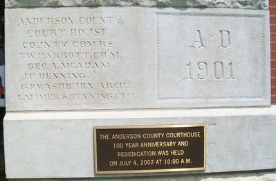
The Anderson County Courthouse
100 Year Anniversary and
Rededication was held
on July 4, 2002 . . . — — Map (db m89198) HM
This ATSF caboose was located in a rail yard in East St. Louis, Illinois. It was owned by the Kansas City Southern Lines and was given to the Garnett, Kansas Lions club. The Lions with financial assistance from the Lake Garnett Racing Assn. . . . — — Map (db m89209) HM
In memory of the
Heroes of '61-'65.
May the deeds of valor of
them and their comrades
forever inspire love of
liberty and country. — — Map (db m71280) WM
“I have now over 200 in camp, and they are in a most deplorable condition….I have a mother with her dying babe in my office. The rest are in camp, in a condition next to death. Most of them have no shelter….Your agent here has no funds, . . . — — Map (db m36270) HM
"But remember this, I am a girl, but I can fire a pistol and if ever the time comes I will send some of you to the place where there is 'weeping and knashing of teeth'...."
Gene Campbell, in a letter to James . . . — — Map (db m54075) HM
"The commands are given, the companies break into column....hardy, dashing looking fellows, those men, tanned up in their march from Fort Scott, from whence they have just joined us....The men are nearly all quite young....They are mounted on . . . — — Map (db m36137) HM
Look at the structures around the parade ground. Fort Scott’s appearance is largely the work of one man, Captain Thomas Swords, post quartermaster from 1842 to 1846. Shortly after the army assigned Swords to Fort Scott, he vowed that he would . . . — — Map (db m36185) HM
In Memory of the Soldiers of the
1st Regiment Kansas Colored Volunteers
who gave their lives in battle May 18, 1863 near Sherwood, Missouri
Henry Aggleson Pvt Co F •
Greene Allen Pvt Co H •
John Booth Pvt Co H •
Edward Cockerell Pvt . . . — — Map (db m116815) WM
In peace you served
as our defender,
in battle our protector,
and in death, a reminder
that Liberty is still
our greatest Strength.
Dedicated in honor
of all who served
in the Armed Forces
of our Country
in the 20th . . . — — Map (db m21258) HM
Civil War Dead
An estimated 700,000 Union and Confederate soldiers died in the Civil War between April 1861 and April 1865. As the death toll rose, the U.S. government struggled with the urgent but unplanned need to bury fallen Union . . . — — Map (db m108813) HM
The back yards of Fort Scott's officers' quarters provided officers and their families private space that was not available to enlisted men. Back yards were the site of diversions such as gardening, gossiping, and entertaining.
Archeology has . . . — — Map (db m36146) HM
Constructed, owned and operated by C.F. Drake as the Bank of Ft. Scott from 1886 to 1905. Later used as real estate, commercial & retail offices. — — Map (db m44165) HM
Constructed as a mercantile building by Charles F. Drake and occupied by a variety of retail stores and professional offices since 1886. — — Map (db m44163) HM
Today when we get hurt, we can call an ambulance and get whisked away to the hospital quickly. During the Civil War, they did not have the luxuries we do today. In the beginning of the war, there were not enough ambulances to carry all the . . . — — Map (db m128668) HM
"If you have reinforcements...send them forward. The point to defend Fort Leavenworth is in the neighborhood of Fort Scott."
General Jim Lane to the commander of Fort Leavenworth, 1861
The army had vacated Fort Scott in 1853, but the . . . — — Map (db m36273) HM
To Honor All Combat
Infantrymen
We were boys and we were young
We became men on that hill we overrun
Some of us lived, many of us died
For a moment with us abide
And join in prayer with me
To honor those of the combat infantry . . . — — Map (db m44169) HM
This statue commemorates the life and legacy of David Lee Regan, the longtime coach who started the Fort Scott High School baseball program in 1990.
With ordinary means, Coach Regan was an extraordinary man who touched the lives of numerous . . . — — Map (db m82234) HM
"A profusion of vegetables - beets, carrots,
onions, potatoes, beans, turnips, and
tomatoes - were harvested from (fort)
garden plots."
'Broadax & Bayonet,' Francis Paul Prucha
General order - "To . . . — — Map (db m128650) HM
Fort Scott tells America's story during a critical time in its growth. When the fort was established, most of the nation's population lived east of the Mississippi. However, soon soldiers from Fort Scott would be part of westward . . . — — Map (db m128757) HM
This western outpost, named for General Winfield Scott, was established by U.S. Dragoons in 1842. The fort was located on the military road that marked the "permanent Indian frontier" stretching from Minnesota to Louisiana and stood midway between . . . — — Map (db m78770) HM
Main marker upper
The men in whose honor this
monument is erected were led by
the fires of Liberty.
They fought for no North, no
South, no East, no West, but for
one glorious and united country.
carving of G.A.R. . . . — — Map (db m22172) WM
This National Cemetery
has been listed in
The National Register
of
Historic Places
by the
United States
Department of the Interior — — Map (db m61520) HM
Civil War Fort Scott
Fort Scott, founded 1842, was named for former commander-in-chief of the U.S. Army, Gen. Winfield Scott. The army abandoned the fort in 1853, but the Civil War prompted federal troops to return in 1862. Fort Scott . . . — — Map (db m108814) HM
"The site selected is a ridge seventy or eighty feet high projecting like a wedge into a dry timbered bottom....A fine stream of water flows at its base....We designated [the site] Camp Scott, and would respectfully suggest that the . . . — — Map (db m36305) HM
If you had been an African-American student standing here around 1950, you would have been facing your school, the Hawkins School (above). This school was part of a continuum of African-American education that began with the Civil War and . . . — — Map (db m36269) HM
Gordon Parks was born on November 20, 1912 in Fort Scott, Kansas to Sarah and Andrew Jackson Parks. Gordon wrote, "Poppa was a dirt farmer who farmed mostly dirt, but he kept us alive and taught us about love and devotion." The youngest of 15 . . . — — Map (db m128781) HM
Homecoming [Side A]
This small town into which I was born, has, for me, grown into the largest, and most important city in the universe. For Scott is not as tall, or heralded as New York, Paris or London - or other places my feet have . . . — — Map (db m79845) HM
(top)
In honored memory of those from Bourbon County who gave their lives
(bottom)
In memory of those who gave their lives that our nation might live.
[The marker lists the veterans who lost their lives in World War . . . — — Map (db m20286) WM
This reconstructed infantry barracks, one of two at Fort Scott, serves to remind us of life for an infantry soldier here in the 1840s and 50s.
During wartime, infantry fought on foot, but during peacetime, life in the infantry meant isolation, . . . — — Map (db m36186) HM
[Side A]
1st Lieut. William D. Hawkins
United States Marine Corps
Born: Fort Scott, Ks April 19, 1914
Battle of Tarawa: November 20-21, 1943
Buried: Punch Bowl National Cemetery, Hawaii
Private George F. Pond
Co. C, 3rd . . . — — Map (db m66811) WM
1925
Memorial Hall was
constructed and dedicated to
"Those men and women who gave their lives
serving our country in World War I"
2001
Memorial Hall is rededicated to
"All of the men and women who have served,
are now . . . — — Map (db m20309) WM
Dedicated this day, June 2003
In memory of
John F. Benage, MD
The cross was originally donated by
Dr. and Mrs. Benage
To Mercy Hospital in 1989
"The cross should be a sign of hope and not of despair.
It reminds us that Jesus Christ . . . — — Map (db m99464) HM
Classic Revival - built for $20,000. Residential and retail bldg. for I.W. Moody owner Ft. Scott Granite & Marble Works
Building listed on the National Register of Historic Places — — Map (db m57765) HM
The quartermaster was the officer responsible for a multitude of functions needed to run a military post, including supply, subsistence, construction, and repair. Most of his operation took place here, in the area called the quartermaster complex. . . . — — Map (db m36171) HM
To see evidence of the rigid military caste system in the Old Army, compare the substantial homes along Officers Row in front of you to the enlisted men's barracks behind you. A soldier's rank determined his position both professionally and . . . — — Map (db m36135) HM
"Every military post shall have one Sutler, to be appointed by the Secretary of War."
General Regulations for the Army of the United States, 1841
About 100 yards in front of you an engraved stone marks the location of Fort . . . — — Map (db m128685) HM
"The immediate site of the post...opens out rapidly to the south in a beautifully undulating prairie."
Assistant Surgeon Joseph K. Barnes, describing the Fort Scott landscape in 1862.
Walk this short trail and imagine "the most . . . — — Map (db m36166) HM
"Fort Scott can boast of the handsomest Square in Kansas Territory."
Fort Scott Democrat, praising the town plaza, April 5, 1860
The grassy square in front of you silently witnessed events that defined Fort Scott and that . . . — — Map (db m36285) HM
The miniature house was built in 1927 by the park caretaker, E.V. Kelly. It was one of his many winter projects. He traveled to Mapleton, Kansas to find the perfect rocks for the walls.
His daughters, Nadine and Jenny, spent many enjoyable hours . . . — — Map (db m53288) HM
Downtown Fort Scott
Historic downtown Fort Scott has roots in a time when it was the last stop before the frontier. Initially comprised of former fort buildings, it soon transformed into a lively downtown commercial district. New permanent . . . — — Map (db m128766) HM
After the army sold Fort Scott in 1855, the infantry barracks located here (reconstructed in front of you) became the pro-slavery Western Hotel. The building across the parade ground directly behind you became the anti-slavery Free State Hotel. . . . — — Map (db m36272) HM
"Bathing is promotive both of comfort and health; and where convenience for it are to be had, the men should be made to bathe at least once a week. The feet are to be washed at least twice a week."
1841 Army Regulations
This foundation, . . . — — Map (db m36168) HM
The brush arbor was located in this general area and was used for a dining area for the troops at Ft. Blair. The colored troops were having lunch here when Quantrill's attackers approached from both the east and the south. The troops made their way . . . — — Map (db m174260) HM
Major General J.G. Blunt left Ft. Scott on October 4, 1863 en route to Ft. Smith. With him was his military escort consisting of about 125 men from Company I, Third Wisconsin Cavalry, and Company A, Fourteenth Kansas Cavalry. They proceeded by way . . . — — Map (db m37627) HM
Erected by the United States to the Memory of the Officers and Soldiers Killed in the Battle of Baxter Springs October 8, 1863, and Other Engagements in this Vicinity who are Buried near this Monument, and . . . — — Map (db m21140) WM
Dedicated in memory of General James G. Blunt and his escort who defenseless, fell victims to the inhuman ferocity of guerrillas, led by the infamous Quantrell in his raid upon Baxter Springs October 6th 1863, in which 135 Union soldiers were slain . . . — — Map (db m80348) HM
On October 6, 1863, Gen. James Blunt and about 100 men were met near Baxter’s springs by William Quantrill and several hundred Confederates masquerading as Union troops. As Blunt’s band was preparing a musical salute the enemy fired. This surprise . . . — — Map (db m37840) HM
On Oct. 6, 1863, Gen. James Blunt and about 125 men from the 3rd Wisc. Cav. and the 14th Kans. Cav. stopped at the creek before coming into Ft. Blair. They were caught in a surprise attack from the rebel forces of William Quantrill. Nearly 100 of . . . — — Map (db m80214) HM
First burial site for victims of the Baxter Springs Massacre and the attack on Ft. Blair. In 1869, the bodies were moved to the National Cemetary plot west of town. — — Map (db m37836) HM
Civil War Dead
An estimated 700,000 Union and Confederate soldiers died in the Civil War (1861-1865). As the death toll rose, the U.S. government struggled with the urgent but unplanned need to bury fallen Union troops. This propelled the . . . — — Map (db m171034) HM
Baxter Springs was named for John Baxter, the area's first European settler in 1849, and the springs on his homestead. A military surveying party who camped in the area in 1857 recounted springs rich in iron salts as rising in a "cone of red mud," . . . — — Map (db m174251) HM
Julius Bischosberger, a native of Prussia, came to Baxter Springs in 1868 and constructed a frame building for the Bischosberger Hotel and Restaurant on this site. Directly across the street to the north was the Bischosberger Livery and Feed . . . — — Map (db m37434) HM
Opened in 1803 by Chief Black Dog (Manka-Chonka) and his band of Osage Indians who had a village nearby where springs once flowed freely. — — Map (db m37839) HM
Built circa 1870, the café was formerly the Crowell Bank, which Jesse James robbed in 1876. It is currently a restaurant and bed and breakfast. — — Map (db m37551) HM
Camp Logan was a 100 acre site of annual G.A.R. reunions attended by veterans of the Civil War between 1883-1914. An amphitheater holding 2000 people was located directly ahead. The surrounding hills were campsites for thousands of veterans and . . . — — Map (db m80220) HM
On this site, G. G. Gregg established the Chicago Drug Store in 1868, just as the town became a center for the cattle trade. The block of businesses was known as Keenan's Old Stand at that time. The Drug Store carried prescriptive and . . . — — Map (db m37501) HM
In 1870-71, the victims of the attack on Fort Blair and the Battle of Baxter Springs were disinterred from a site near the fort and reinterred in this newly designated national cemetery plot, officially National Cemetery #2. — — Map (db m171037) HM
In a field to the east, Blunt's military band wagon overturned while trying to escape the guerillas. The bandsmen were shot and their bodies were burned in the wagon. — — Map (db m170671) HM
The first bank in Baxter Springs was the Bank of Baxter also called the Crowell Bank. It was established in 1870 and did business in this building. H. R. Crowell, the founder, was the second mayor of Baxter Springs. In May of 1876, Jesse James and . . . — — Map (db m37531) HM
In the late 1880s, this building was constructed by W. H. Horner, and in it he established the Drovers' and Farmers' Bank. The Bank was purchased by John M. Cooper and J. N. McDonald, who changed the name to the Traders' Bank. They were later . . . — — Map (db m37502) HM
In 1866, a small log school building was built on this site, with benches and desks hewn from logs. The first teacher was Miss Lillie Van Epps. It was a subscription school, which was maintained, and the teacher paid with tuition from the students. . . . — — Map (db m80341) HM
Fort Blair, constructed as a garrison for soldiers guarding the Military Road, was attacked by rebel forces of William Quantrill on Oct. 6, 1863.
Although greatly outnumbered, Lt. James Pond and men from the 3rd Wisc. Cav. and Kans. 2nd Colored . . . — — Map (db m37838) HM
This is a replication of the blockhouse which records tell us was in the center of the encampment. The original blockhouse measured 16 feet square and was constructed of logs. It was built to store equipment and supplies. Reports indicate that it . . . — — Map (db m37621) HM
The breastworks that enclosed Ft. Blair measured 80 feet by 100 feet. A trench, called a rifle pit, encircled the breastworks on the inside. The dirt that was extracted to create the rifle pits was then piled outside the walls to provide a . . . — — Map (db m37599) HM
The west wall of the breastworks had been removed the day before the attack in order to enlarge the encampment to make room for more than 100 additional cavalry troops which had arrived under the command of Lt. Pond. — — Map (db m37623) HM
The Illinois Cash Store, a grocery and dry goods store, was constructed on this site in 1868 by John M. Cooper who came to Baxter Springs from Illinois. In 1886, he constructed a new brick building one block south and moved the business. in 1900, . . . — — Map (db m52061) HM
The Indiana Hotel, later renamed the Indiana House, was constructed on this site around 1870.
Christian Null acquired the Indiana House in 1881 and operated the business until its closing in the late 1890s. In 1900, the present building was . . . — — Map (db m37533) HM
In the spring of 1849, John Baxter, his wife and 8 children moved to this site and built an inn and general store and offered food and lodging to travelers who passed along the Military Road. Baxter was a colorful character -- a speculator, . . . — — Map (db m37598) HM
In the spring of 1849, John Baxter, his wife and 8 children moved to this site and built an inn and general store and offered food and lodging to travelers who passed along the Military Road. Baxter was a colorful character - a speculator, business . . . — — Map (db m272261) HM
This grand building was entered on the National Register of Historic Places in 1976. Built in 1872, it was intended to be the county courthouse, but was never used for that purpose. Through the years, the building has served as a city hall and a . . . — — Map (db m80350) HM
This small bridge is the last of its kind in Cherokee County. Given to the historical society by the county commissioners, it was moved to this site in 1994 from the northwest corner of the county. — — Map (db m80332) HM
This log cabin was built east of the Lowell Cemetery in the late 1870's. R.A. Hibbard built it as a home for his brother-in-law's family. Kent Lynch purchased the property and donated the cabin to the historical society in memory of Marsha Moncrief . . . — — Map (db m80219) HM
In 1872, the Mayor of Baxter Springs, J. R. Boyd, shot and killed C. M. Taylor, marshal, near this spot. Bad blood had existed between the two for some time.
The marshal approached Boyd to serve him a warrant for arrest on an assault charge. . . . — — Map (db m37437) HM
Henry and Louisa Ohlen purchased this property in February 1878 and opened Ohlen's Restaurant and Bakery. Among their offerings were ice cream and oysters which were advertised "in their proper seasons." The Ohlen's [sic] also offered a day . . . — — Map (db m37505) HM
J. P. Opperman, a native of France, came to Baxter Springs in 1871 and established the Opperman Harness and Saddle Shop located on this site. The building is still here, but lies beneath the present facade. Opperman's was one of the most successful . . . — — Map (db m37471) HM
Built in 1930 by the Independent Oil
and Gas Company, this Tudor
Revival style gas station was
purchased by Phillips 66 Petroleum
Company the same year. The
original "house" style brick building
was modified in the 1940s to the . . . — — Map (db m37388) HM
In May of 1893, the Polster Brothers, Charles, John and Ed, and their mother, Elizabeth Polster, had a grand opening for their new dry goods store. The public was entertained with music by an Italian harpist, and the building was lavishly decorated . . . — — Map (db m37503) HM
Near this site, Quantrill's men attacked and killed several men from the fort engaged in target practice. Among them were Johnny Fry, an Army scout who had earlier won fame as the first Pony Express rider, and Lt. Ralph Cook, officer in charge of . . . — — Map (db m80331) HM
477 entries matched your criteria. The first 100 are listed above. Next 100 ⊳