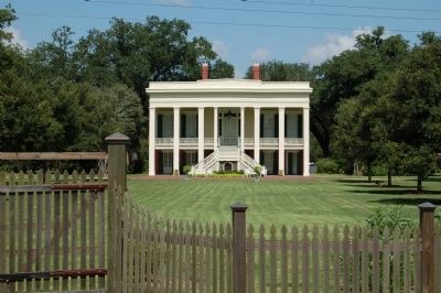
Built in 1801 by Marius Pons Bringier as wedding gift for daughter Fanny, who married Christophe Colomb, a French refugee. Remodeled by Architect James Dakin 1837. Restored by Dr. & Mrs. E.G. Kohlsdorf 1941. — — Map (db m85285) HM
Houmas Indian land grant sold to Conway and Latil in 1774. Sold to Revolutionary War hero Wade Hampton 1811. Greek revival mansion built by John Smith Preston in 1840. Restored by Dr. George Crozat in 1940. — — Map (db m109683) HM
Greek Revival mansion built by Marius Pons Bringier as wedding gift for his son Michael Douradou, who named the house for General Andrew Jackson's home in Tennessee. The Jacksons visited here in the 1820s. — — Map (db m141734) HM
Built in 1855 by Benjamin F. Tureaud, kinsman of Bringier family. Constructed of homemade red brick and Louisiana cypress. Purchased in 1888 by Dr. Julian T. Bringier. Retained by relatives until the 1940s. — — Map (db m85284) HM
This quiet neighborhood between the river and the railroad retains a number of historic features related to the struggles and achievements of Louisiana African Americans. The Rosenwald School building in front of you was relocated from a site 15 . . . — — Map (db m155974) HM
Claiborne Williams
(Donaldsonville) •
George Williams
(Donaldsonville) •
Bella Sullivan
(Donaldsonville) •
Jelly Roll Morton
(New Orleans) •
Albert Carroll
(Donaldsonville) •
Renald Richard
(Thibodaux) •
Homer Richard . . . — — Map (db m244142) HM
This church founded August 15, 1772 by Father Angel de Revillagodos on orders of King Charles III of Spain. Cornerstone of present church laid June, 1876 by Bishop Elder of Natchez and the April 14, 1896 dedication by Archbishop Janssens of New . . . — — Map (db m86048) HM
French missionary priests arrived here in 1704 to evangelize the Chetimaches Indians. Around 1770, Spanish militiamen built a log chapel here. In 1819 the parish erected the first official church building, followed by a brick church in 1843. . . . — — Map (db m155327) HM
Once a course of the Mississippi River, Bayou Lafourche helped shape Louisiana's coastline by carrying fresh water, sediment and nutrients south to the Gulf of Mexico.Bayou LaFourche is a 106-mile waterway that stretches from Donaldsonville to . . . — — Map (db m111250) HM
Jazz developed at the turn of the 20th century in south Louisiana and was born from a combination of musical traditions: work songs, spirituals, blues, and ragtime. From the early days of vaudeville and minstrel shows to the formidable first years . . . — — Map (db m86822) HM
We dedicate this memorial in honor of our
Spanish ancestors from the Canary Islands
who, in the 18th century, sailed to Louisiana
where they settled and prospered, thus
fulfilling God's will as written in Holy
Scripture: Be fruitful and . . . — — Map (db m155328) HM
It began in 1912, Booker T. Washington, President of Tuskegee Institute,
approached Julius Rosenwald, President of Sears, Roebuck and Company, with
an idea for a pilot program that was to have a dramatic impact on the face of
America. . . . — — Map (db m154213) HM
This building built in 1868 served as the Ascension parish Courthouse and jail. On June 1, 2017, the Ascension Parish Council officially changed the name to Charles "Chalou" Trepagnier Building in honor of his 51 years as a law enforcer.
Born . . . — — Map (db m123662) HM
Dedicated to the memory of
Sidney A. Marchand, Jr.
1917-1956
Mayor, City of Donaldsonville, 1948-1956
Soldier: World War II Normandy Invasion
St. Lo Breakthrough, Race to Paris,
St. Vivth Bastogne, Hurtgen Forest,
Seigfried Line. . . . — — Map (db m244013) HM
River travelers in the 1800s disembarked from their vessels on the levee behind you. For most of them, this crescent-shaped park was their first stop in the most developed river town north of New Orleans. Amid the whistles of riverboats and the . . . — — Map (db m155998) HM
Dedicated To The Memory Of These Men Of Ascension Parish Who Gave Their Lives In The Services Of Their Country In World War I and World War II — — Map (db m126726) WM
Made capital of Louisiana in 1830; Legislature met from January 4 to March 16 and reconvened in 1831. In 1848 the old State House, located across from this site, was razed, and its bricks used to prevent wavewash at the bayou's mouth. — — Map (db m85189) HM
Second Acadian Coast. Town founded by William Donaldson, 1806, on farm of Pierre Landry. Began as trading post about 1750. Home of Governor Francis T. Nicholls, of Dr. F.M. Prevost, who performed the first Caesarean section, 1824. Parish seat of . . . — — Map (db m223363) HM
Many of the Africans brought to
Louisiana during the colonial period
were from the Senegambia area
of West Africa. The Africans who
were brought to America were selected
largely because of their agricultural and
technological knowledge and . . . — — Map (db m243974) HM
Recognizing the strategic importance of this river port at the mouth of Bayou Lafourche, Union forces built Fort Butler on this site in late 1862. The earthen, log and brick structure no longer exists.On the evening of June 27, 1863, Confederate . . . — — Map (db m155976) HM
(left panel)
"We are still anxious as we have ever been to show the world that the latent courage of the African is aroused, and that , while fighting under the American Flag, we can and will be a wall of fire and death to the enimies of . . . — — Map (db m86323) WM
(center panel)
The Finest of Texas and Arizona,
Lives lost by river and bayou.
We mark their graves,
Remember their names:
Brave Confederates who died
At Fort Butler, June 28, 1863.
Martha M. Boltz
Virginia Division - . . . — — Map (db m86049) WM
On the site directly across from this marker Francis T. Nicholls — Confederate General, Governor and Chief Justice of the State Supreme Court — was born and reared. Additional French marker Francis T. Nicholls 1834-1912 A cet . . . — — Map (db m85191) HM
The enslaved workers passed travel instructions from
plantation to plantation by song. They brought from
Africa the custom of creating songs that transmit
factual information. In America, the enslaved
Africans turned song into codes that . . . — — Map (db m244010) HM
Imagine the landscape in front of you in the late 1600s: the wild wetlands of the fierce Chitimaches Indians. Sieur de la Salle sailed his ship past here in 1682, claiming all he surveyed for France. But in 1806, Englishman William Donaldson . . . — — Map (db m156746) HM
This elegant memorial park recalls many eras of southern Louisiana history. The Ascension Parish Courthouse to your right is the most prominent landmarks today, but this square designed in 1806 has witnessed important events in regional . . . — — Map (db m155365) HM
The Underground Railroad was not underground,
not a railroad, and not a single route or system of
trails. It was the term used to describe both random
and concerted effort for people to free themselves
from bondage. Louisiana's stories of . . . — — Map (db m244012) HM
This great waterway is the most prominent natural feature of Louisiana. The high bank, or levee, you are standing on protects Donaldsonville from flooding. A birds-eye view reveals we are located between two great river bends.Events on and around . . . — — Map (db m155312) HM
Scene of Civil War skirmish in fall of 1862. C.1850 Greek Revival plantation house owned 1854-1869 by Charles A. Kock, a prominent sugar planter. Listed on National Register of Historic Places in 1980. — — Map (db m96047) HM
Despite long hours of work, slaves were able to make
time for family and religion, further developing their own
culture. The plants that were found and used on the Underground
Railroad are as unknown as the secret routes that remain
to be . . . — — Map (db m244047) HM
The enslaved Africans who worked as
cooks on the plantations had access to food
supplies which aided runaways. The cypress
swamps of Louisiana became a magnet for
runaways and free blacks. A common bond
developed between the African . . . — — Map (db m244019) HM
This facility is dedicated to the memory of Walter Lemann, Sr. (1879-1952) a citizen of Donaldsonville whose untiring efforts to restore a flow of fresh water to Bayou Lafourche continued from its closure in 1903 until his death.
It was his . . . — — Map (db m86047) HM
Panel 1
This monument dedicated in memory of all veterans who served the United States Armed Forces in defense of freedom and peace, having fought bravely against tremendous odds on land, sea and air, were no less honorable, valiant and . . . — — Map (db m96911) WM
Once enslaved at Ashland Plantation, became noted 19th century African American jockey. Rode the horse Lecompte to victory over Lexington in 1854 in New Orleans. Inducted into the Louisiana Racing Museum Hall of Fame in 1997. — — Map (db m84995) HM
Plantation home of Duncan Farrar Kenner, 1813-1887; statesman, lawyer, planter and Confederate minister to France and England in 1864. Home also known as Belle Helene. — — Map (db m96048) HM
As U.S.-led coalition forces began to unleash a ferocious air war on Iraq with Operation Desert Storm, Iraq's dictator Saddam Hussein took to state radio, telling his people "the great duel, the mother of all battles has begun...the dawn of victory . . . — — Map (db m115062) HM
U.S. President Woodrow Wilson had lofty goals for World War I, including his hope that the war would create a set of conditions that made future wars impossible. Along with his plea that the war should be fought "to make the world safe for . . . — — Map (db m114884) HM WM
A young resident of Donaldsonville named Private Bennett J. Babin wrote the following letters while serving in the trenches in France in 1918. The first was written to G.D. Bentley, the editor of The Donaldsonville Chief, a weekly newspaper serving . . . — — Map (db m115002) HM WM
Long-time Ascension Parish residents Sergeant Major Chad Lynch, Major Cindy Haygood, Sergeant First Class Bonnie Hymel, and First Sergeant Chad Anderson played vital roles in the Iraq War. They were sent in as part of what became known as the "Iraq . . . — — Map (db m114932) HM WM
Cal Ripken, Sr. signed his first baseball contract in 1956. Over the next 36 years, he served as player, coach and manager within the Baltimore Orioles' organization. Every step of the way, Cal Ripken, Sr. led by example - loyalty, hard work, . . . — — Map (db m198960) HM
Louisiana occupied a highly strategic location during the Civil War. Home to both the South's largest city, New Orleans, as well as the largest Confederate training base in the Gulf South at Camp Moore, and positioned to control the mouth of the . . . — — Map (db m114854) HM WM
Union efforts in the western theater of the war centered on seizing control of the many rivers and streams that pierced the Southern heartland. Employing ironclad warships capable of destroying the South's outdated masonry forts, Union forces . . . — — Map (db m114997) HM
Many of the most climactic and large scale battles occurred in the eastern theatre of the war, primarily Virginia. With the capital cities of both North and South in perilous proximity of one another, much of the fighting in the east naturally . . . — — Map (db m114999) HM
During the first year of the Korean War, President Harry Truman and General Douglas MacArthur, the man Truman put in charge, started to have fundamental disagreements about the methods and overall purpose of the war. MacArthur came to believe that . . . — — Map (db m114991) HM WM
In response to Iraq's invasion of Kuwait in August 1990, U.S. President George H.W. Bush ordered 540,000 American troops to the sands of Saudi Arabia to protect it from Iraqi encroachment and to convince Iraq to leave Kuwait. Louisiana residents . . . — — Map (db m114933) HM WM
One of America's most important literary figures, Ralph Waldo Emerson (May 25, 1803 - April 27, 1882), wrote these words that turned out to be prophetic. Before the Mexican-American War began, Emerson predicted that "the U.S. will conquer Mexico, . . . — — Map (db m114882) HM
Dedicated to the men and women wounded in all our wars preserving the freedom of the United States of America. Veterans In God We Trust. Rear of Memorial Each Purple Heart shall always be
a part of freedom's history
Hold deep inside a fervent . . . — — Map (db m196847) WM
"AND THE ROCKETS' RED GLARE, THE BOMBS BURSTING IN AIR, GAVE PROOF THROUGH THE NIGHT THAT OUR FLAG WAS STILL THERE."---“Star Spangled Banner" By Francis Scott Key In September 1814, an American lawyer named Francis Scott Key was sent to . . . — — Map (db m114831) HM
Only 69 miles from where you are standing, the most significant battle of the War of 1812 was fought, the Battle of New Orleans. Ironically, it was neither fought in New Orleans, nor was it fought during the official War of 1812. Instead, it was . . . — — Map (db m114830) HM
Background Throughout the antebellum period, the Northern and the Southern United States developed divergent economies as the North industrialized and commercialized while the South's mild climate and extended growing season allowed it to . . . — — Map (db m115035) HM
Dedicated to all the men and women who paid the ulitmate price in service to their country. This nation was
conceived in liberty and built upon these sacrifices
over the centuries. If this country stands for one shining ideal, it is on our . . . — — Map (db m196848) WM
Panel 1 The Korean War (June 25, 1950 - July 27, 1953) erupted in 1950 when the Democratic People's Republic of Korea (North Korea) invaded the Republic of Korea (South Korea). What started as a civil war quickly turned into a matter of . . . — — Map (db m115122) HM
Three Louisiana men played prominent roles in the Mexican-American War. Though John Slidell was born in New York, he moved to New Orleans in 1819, started a successful law practice, and eventually became an important leader of the Democratic Party . . . — — Map (db m114832) HM
Panel 1 Fifteen years before Americans began fighting each other in the Civil War, they were at war with their neighbors to the south in Mexico. The Mexican-American War began in 1846 and lasted less than two years with the Americans achieving a . . . — — Map (db m114839) HM
Panel 1 At the stroke of midnight on August 2, 1990, Iraqi troops blasted across the border of their tiny oil-rich neighbor to the south in Kuwait in order to occupy and annex the small sheikdom and gain control of its ample oil reserves. . . . — — Map (db m115151) HM
Panel 1 Much like the Korean War before it, the Vietnam War started as a civil war in Asia, but quickly evolved into an international matter because it became yet another manifestation of the Cold War. By 1954, a communist regime controlled . . . — — Map (db m259140) WM
Panel 1Only twenty-nine years after winning its independence from Great Britain in the American Revolutionary War, the United States found itself at war once again with its former mother country. The War of 1812 began on June 18, 1812 when Congress . . . — — Map (db m114827) HM
Toppling the Taliban (October 2001 - December 2001)Within days of the terrorist attacks of September 11, 2001, the U.S. government blamed Al Qaeda, a group of Islamic extremists led by Osama bin Laden in Afghanistan. The Taliban, an Islamic . . . — — Map (db m115816) HM WM
Out of the clear blue morning sky of September 11, 2001, war came to America. Nineteen hijackers seized four passenger planes and flew them as manned missiles directly into symbols of American financial and military power. Two planes struck the . . . — — Map (db m115804) HM WM
Remembering the men and women of Viet Nam America's forgotten Hero You are America's forgotten hero A fate you didn't deserve. To the Battlefield you did go fighting with prideful nerve. In Honor of the men and women of Desert Storm . . . — — Map (db m198940) WM
Deposing a Dictator: Invading Iraq and the Overthrow of Saddam Hussein (March 2003 – May 2003)By the end of 2002, President George W. Bush had become dissatisfied with Saddam Hussein's level of cooperation with U.N. weapons inspectors . . . — — Map (db m115805) HM WM
Panel 1 BackgroundWorld War I, also known as the Great War, was a global clash between most of the world's great powers from 1914 to 1918. The participating nations divided themselves into two camps. On one side, Austria-Hungary, Germany, . . . — — Map (db m115036) HM
Background Twenty years after the "the war to end war," World War I, a far more brutal, destructive, and deadlier conflict broke out—World War II. Fought from 1939 to 1945, the Second World War included almost every nation in the world, . . . — — Map (db m115794) HM WM
The Big Three Agree While the American soldiers were proving their worth in the Mediterranean (see the panel War in the Mediterranean), they still had not made a huge impact in western Europe, mainly because the British Prime Minister . . . — — Map (db m115788) HM WM
By December 11, 1941, the U.S. was officially at war with all three major Axis powers, but most Americans wanted to see the Japanese head of the three-headed monster cut off first because of what happened at Pearl Harbor. American military . . . — — Map (db m115796) HM WM
Post Pearl Harbor American and British military planners decided on a strategy of “Europe First", but that did not mean “Neglect Japan Entirely.” Indeed, fierce fighting took place in the Pacific in the immediate aftermath . . . — — Map (db m115786) HM WM
Site of the plantation of the Jean Baptiste Gaudin Family from 1830 to 1874. Gaudin, a native of St. James Parish, established Gaudin Home Place from several small farms. He grew cotton then sugarcane. In time he would own over 1000 arpents . . . — — Map (db m87261) HM
Old Spanish town at junction of Amite River and Bayou Manchac. Settled by Anglo-Americans, 1776-78, seeking Spanish refuge from American Revolution and by Canary Islanders (Islenos). Named for Spanish Governor Bernardo de Galvez. Town was abandoned . . . — — Map (db m85246) HM
The site of this cemetery, being one of the highest spots in east Ascension Parish, was used to bury those who died during crevasses. About the year 1785, Joseph Dupuy donated it as a non-sectarian cemetery, including slaves and Indians.
Joseph . . . — — Map (db m86105) HM
(side 1)
The Ascension Parish Negro Fair Association, Inc.
The APNFA, Inc. was established September 22, 1950 by concerned citizens in the Prairieville area. The Association assisted and encouraged the advancement of farming, . . . — — Map (db m85750) HM
"Where we love is home—
home that our feet may leave
but not our hearts."
Oliver Wendell Holmes
Founded by
Gustave Joseph De La Barre
Circa 1900 — — Map (db m85518) HM
Israel Baptist School. In 1872, Reverend Osborne Dickerson and the First Israel B. C. congregation organized the Baptist Church School on this site to provide formal education for African American children. In 1877, Assumption Parish School . . . — — Map (db m86041) HM
Founded under Spanish rule c. 1778 by Canary Islanders, later joined by Acadians and others. Post believed to have been on site of "Belle Alliance Plantation," 841 acre grant to Don Juan Vives, early Spanish physician, officer in the Galvez . . . — — Map (db m86034) HM
First major battle fought along Bayou Lafourche during the War Between the States. Marching from Donaldsonville Union forces under General Weitzel (8th NH, 12th & 13th CT) attacked General Mouton (Ralston's Battery, 24th & 18th LA and the Terrebonne . . . — — Map (db m85249) HM
Assumption Parish
dedicates this memorial
to the memory
of those who
gave their lives
in the
service of their Country
World War II
1941-1945
Clifton Ambrose
Tuite H. Ambrose
Joycee C. Amos
Roland P. Aucoin
Charles . . . — — Map (db m88363) WM
Site of Elm Hall Plantation donated by Dr. E. E. Kittredge. Congregation organized and church constructed in 1853. Frank Willis, Architect. Consecrated by the Rt. Rev. Leonidas K. Polk in 1854. W.W. Pugh, Warden, 1853-1905. — — Map (db m87901) HM
Erected by the citizens of Assumption Parish in honor of her sons who served their country in the Great War for the preservation of democracy and in loving memory of those who made the supreme sacrifice for the triumph of the free peoples of the . . . — — Map (db m88268) WM
The first major building designed by noted architect Henry Howard. Construction of this Greek Revival mansion was begun in 1846, using materials from the land. Steamboats carried trade to Madewood on Bayou Lafourche. — — Map (db m87862) HM
Nommée en l'honneur de l'Empereur Napoléon Ier, la ville est sur une ancienne voie de communication, 1730-1770, empruntée par les Francais puis par les Acadiens, pour aller de St-James jusqu'au port des Attakapas, sur le lac Verret.
Ce lac . . . — — Map (db m87863) HM
The community of Pierre Part in nearly surrounded by water and was inaccessible by land until the Mid-20th century, thus isolated from much of the world. Bayous lace this portion of south Louisiana. The highest land in the area is located . . . — — Map (db m111809) HM
This Memorial
dedicated to all the
men and women who
served their Country in
time of war and peace.
All gave some
and
some gave all. — — Map (db m228942) WM
Commemorates The Blessed Virgin who the people of Pierre Part believe intervened to save lives in natural disasters from 1882-1976. Restored by the citizens during the Bicentennial Year 1976. — — Map (db m85754) HM
Commemorates The Blessed Virgin who the people of Pierre Part believe intervened to save lives in natural disasters from 1882-1976. Restored by the citizens during the Bicentennial Year 1976. — — Map (db m98425) HM
West of this marker lies the grave site of a Union Soldier who was killed in a skirmish with Confederate soldiers at Bayou Goula on January 25, 1865. His name is believed to be Private David Ingraham, Third Rhode Island Calvary, Company H. He was . . . — — Map (db m91986) HM
Mugulasha Indian village captured by Bayogoulas. In 1699 Bienville here found Tonti's letter of 1686 to La Salle. Father Paul Du Ru built first chapel in Louisiana near village in 1700. — — Map (db m138446) HM
A Memorial to Paulin Verret by his children in 1926. He was a free African-American wealthy planter in Bayou Goula prior to Civil War. Land donated was forty-eight feet wide and three arpents deep, for African-Americans of Iberville. — — Map (db m91983) HM
In 1723 Raphael of Luxemburg came to establish Missions at French Posts and among Indians. Served as Vicar-General of Louisiana Colony under Bishop of Quebec.
Built first St. Louis parish church and Catholic School in N.O. Thus began the . . . — — Map (db m85024) HM
Bayou Sorrel Indian Mound is one of the most prominent in Atchafalaya Heritage Area.
Archaeological investigation in 1913 by Clarence Moore
include artifacts from Tchefuncte, Marksville, Baytown,
Coles Creek or Plaquemine Period. After the . . . — — Map (db m121179) HM
The Gulf Intracoastal Waterway was designed primarily for commercial traffic but is also used by recreational boaters. It allows vessels and goods to travel more than 1,300 miles through safer waters inland from the Gulf of Mexico.Completed in . . . — — Map (db m111259) HM
Indian Camp Plantation, Henry Howard, Architect, Built 1859, Wood, Masonry & Steel, Sq.Ft. 17,042Facing River Road in a prominent position at the entrance to the grounds is Indian Camp Plantation, the most important single architectural feature . . . — — Map (db m111579) HM
Harry was a "bull" chimp (alpha male). His importance in Laboratory Research was that his blood was used to make an extract called transfer factor that was given to patients. His "official" designation was a special study case "Harry T. . . . — — Map (db m104365) HM
The plantation home, built in the 1850's, became the site of the Louisiana State Leprosarium in 1894. The U.S. Public Health Service acquired it in 1921. It is now known as the National Hansen's Disease Center. — — Map (db m94327) HM
The original on-site staff housing began when the Daughters of Charity arrived in April of 1896 to care for the leprosy patients. They lived in the old plantation, Indian Camp. When the US Public Health Service officers took operational control . . . — — Map (db m98455) HM
In 1895, the Louisiana Leper Home Board of Control needed to secure nursing services for the first patients. They approached a Catholic nursing order with the promise of furnishing sleeping and living arrangements. The Daughters of Charity of St. . . . — — Map (db m104258) HM
The Sixty-six STAR was born in 1931, with Stanley Stein as its editor. The name was selected by Carville patient and Texas pharmacist, Stanley Levyson (AKA Stanley Stein). It was first published as a mimeograph sheet dealing with hospital . . . — — Map (db m104261) HM
In 1894, The Louisiana Leper Home was established at an abandoned plantation south of Baton Rouge, near a town eventually known as Carville. That November, the first seven patients, transferred from a "pest house" in New Orleans, arrived on a coal . . . — — Map (db m104257) HM
Built in 1847 by Dr. Edward Scratchley. Occupied as school by Marianite Sisters from 1859-1862 & 1865-1975. Occupied as military command by Union Army 1862-1865. Renovated by Lt. Governor and Mrs. Robert L. Freeman-1990 — — Map (db m87254) HM
Le passage des Acadiens Pendant après la de'portation de 1755 depuis le Canada jusqu'aux Attakapas de Sud-ouest.
Passageway of Acadians after deportation of 1755 from Canada to the Southwest Attakapas. — — Map (db m87228) HM
1118 entries matched your criteria. The first 100 are listed above. Next 100 ⊳