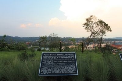
On Cameron Lane north of Gateway Avenue, on the right when traveling north.
November 23d, 1863, under instructions from Gen. Grant to ascertain whether the Confederates still occupied the valley, Gen. Thomas disposed forces in front of Fort Wood, the site of which is now marked by the stand-pipe of the water works.
The . . . — — Map (db m58999) HM
On Cameron Lane north of Gateway Avenue, on the right when traveling north.
During the night of Nov. 23, 1863, Gen. Sherman crossed the Tennessee at the mouth of the Chickamauga, under orders to carry the north end of Missionary Ridge to the railroad tunnel. He seized the ground now known as Sherman Heights and held it . . . — — Map (db m59018) HM
On Cameron Lane north of Gateway Avenue, on the right when traveling north.
During the night of Nov. 24, 1863, Bragg's forces withdrew from the plain and Lookout and joined those on Missionary Ridge, occupying it from Rossville to Tunnel Hill, and a spur thence eastward to the Chickamauga. Sherman early on the 25th . . . — — Map (db m81651) HM
On West 10th Street west of Broad Street, on the left when traveling west.
This city was first occupied by Confederate troops in the spring of 1862 under Generals Floyd, Maxey and Leadbetter. Union troops under General Mitchell shelled it June 7 and 8. Bragg's Army occupied it in August preparing for the Kentucky campaign, . . . — — Map (db m87279) HM
This city was first occupied by Confederate troops in the spring of 1862 under Generals Floyd, Maxey and Leadbetter. Union troops under General Mitchell shelled it June 7 and 8. Bragg's Army occupied it in August preparing for the Kentucky campaign, . . . — — Map (db m81670) HM
On Georgia Avenue south of McCallie Avenue, on the right when traveling north.
This city was first occupied by Confederate troops in the spring of 1862 under Generals Floyd, Maxey and Leadbetter. Union troops under General Mitchell shelled it June 7 and 8. Bragg's Army occupied it in August preparing for the Kentucky campaign, . . . — — Map (db m81671) HM
On Orchard Knob Avenue north of Ivy Street, on the left when traveling north.
[First Tablet]
Battle of Chattanooga.
Nov. 23 - 25, 1863.
—————————
Gen. Grant had under his command for the Battle of Chattanooga the Army of the . . . — — Map (db m43472) HM
On Orchard Knob Avenue north of Ivy Street, on the left when traveling north.
[First Tablet]
Battle of Chattanooga.
Nov. 23 - 25, 1863.
—————————
Gen. Grant had under his command for the Battle of Chattanooga the Army of the . . . — — Map (db m43472) HM
Near Point Park Road 0 miles north of East Brow Road (Route Natin).
No Union troops reached the top of the Mountain during the Battle of Lookout. The Confederates began to withdraw from the summit at 7 P.M. of the 24th, and completed the retirement about 9 o'clock, and at 10 P.M. had crossed Chattanooga Creek on . . . — — Map (db m81685) HM
No Union troops gained the top of Lookout Mountain during the battle. Before daylight the next morning thereafter, General Whitaker, commanding brigade in Cruft's Division of the Fourth Corps, called for volunteers from the Eighth Kentucky to scale . . . — — Map (db m68943) HM
On Cameron Lane north of Gateway Avenue, on the right when traveling north.
After Chickamauga, the Confederates by holding Lookout Mountain and Valley, closed the river line of supplies. Rosecrans' plan for its re-opening was to move Hooker's force from Bridgeport into Lookout Valley, Gen. W. F. Smith to co-operate from . . . — — Map (db m58994) HM
On Cameron Lane north of Gateway Avenue, on the right when traveling north.
On June 7 and 8, 1862, General Negley in command of a Union reconnoitering force appeared on Stringer's Ridge northwest of this point, and screened by the timber opened with artillery on the city and line of rifle pits (then under command of Gen. . . . — — Map (db m58997) HM
Near Shingle Road 0.1 miles north of Military Road when traveling north.
Tablet #1 Union Batteries 7th Indiana (Sec) Lt. Otho H. Morgan Baird Mouth Chatta. Creek 10th Indiana Capt. Wm. A. Naylor Sheridan Moccasin Point 1st Iowa Lt. James M. Williams Osterhaus W. of Lookout Creek 2d Missouri . . . — — Map (db m35750) HM
Union Casualties - Battle of Chattanooga. Nov. 23d to Nov. 27th, 1863.The losses here given by Divisions include Orchard Knob, Lookout Mountain, Missionary Ridge and operations following as far as Ringgold Gap, GA.
Cruft's Div., 4th Corps - . . . — — Map (db m43486) HM
Near North Crest Road south of Brown Wood Drive, on the left when traveling north.
Union Casualties - Battle of Chattanooga. Nov. 23d to Nov. 27th, 1863.The losses here given by Divisions include Orchard Knob, Lookout Mountain, Missionary Ridge and operations following as far as Ringgold Gap, GA.
Cruft's Div., 4th Corps - . . . — — Map (db m103530) HM
Near Orchard Knob Avenue north of Ivy Street, on the left when traveling north.
Union Casualties - Battle of Chattanooga. Nov. 23d to Nov. 27th, 1863.The losses here given by Divisions include Orchard Knob, Lookout Mountain, Missionary Ridge and operations following as far as Ringgold Gap, GA.
Cruft's Div., 4th Corps - . . . — — Map (db m44576) HM
Union Casualties - Battle of Chattanooga. Nov. 23d to Nov. 27th, 1863.The losses here given by Divisions include Orchard Knob, Lookout Mountain, Missionary Ridge and operations following as far as Ringgold Gap, GA.
Cruft's Div., 4th Corps - . . . — — Map (db m57906) HM
Near North Crest Road north of Lightfoot Mill Road.
Union Casualties - Battle of Chattanooga. Nov. 23d to Nov. 27th, 1863.The losses here given by Divisions include Orchard Knob, Lookout Mountain, Missionary Ridge and operations following as far as Ringgold Gap, GA.
Cruft's Div., 4th Corps - . . . — — Map (db m57904) HM
Near Orchard Knob Avenue north of Ivy Street, on the left when traveling north.
No. 9......................................U.
Field Headquarters of the Union Armies.
Maj. Gen. Ulysses S. Grant
Nov. 25th, 1863.
General Grant was assigned to the Military Division of the . . . — — Map (db m43425) HM
[Text on the 1st Tablet]:
Army of the Tennessee
Maj. Gen. William T. Sherman.
November 24 - 25, 1863.
1st Division, 15th Corps. Brig. Gen. Peter J. Osterhaus.
2nd Division, 15th Corps. Brig. . . . — — Map (db m58220) HM
Near Orchard Knob Avenue north of Ivy Street, on the left when traveling north.
No. 11...........................................................U.
Fourth Army Corps.
Maj. Gen. Gordon Granger.
Nov. 25th, 1863.
1st Division-Brig. Gen. Charles Cruft.
2d Division-Maj. Gen. . . . — — Map (db m43429) HM
Near Orchard Knob Avenue north of Ivy Street, on the left when traveling north.
Fourteenth Army Corps.
Maj. Gen. John M. Palmer.
Nov. 19-25, 1863
Johnson's Division - Brig. Gen. Richard W. Johnson.
Davis' Division - Brig. Gen. Jefferson C. Davis.
Baird's Division - Brig. Gen. Absalom . . . — — Map (db m43455) HM
Geary's Division, (12th Corps) Brig. Gen John W. Geary. Cruft's Division, (4th Corps) Brig. Gen. Charles Cruft. Osterhaus' Division, (15th Corps) Brig. Gen. Peter J. Osterhaus. The advance of General Hooker's command from the Army of the Potomac, . . . — — Map (db m218099) HM
On Chickamauga Avenue (U.S. 27) at West Gordon Avenue on Chickamauga Avenue.
Hooker's Column.
Maj. Gen. Joseph Hooker.
Nov. 25, 1863, 3 P.M.
Osterhaus' Division, 15th Corps - Brig. Gen. Peter J. Osterhaus.
Cruft's Division, 4th Corps - Brig. Gen. Charles Cruft.
Geary's Division, 12th . . . — — Map (db m46556) HM
On North Crest Road north of Brown Wood Drive, on the left when traveling north.
Baird's Division, Palmer's Corps
Brig. Gen. Absalom Baird.
Nov. 25, 1863, 5 P.M.
1st Brigade, Brig. Gen. John B. Turchin.
2nd Brigade, Col. Ferdinand Van Derveer.
3rd Brigade, Col. E. H. Phelps.
3rd Brigade, Col. William H. . . . — — Map (db m81650) HM
On West Crest Road near Waheela Road, on the right when traveling west.
No. 3...................................... U.
Cruft's Division - Granger's Corps
Brig. Gen. Charles Cruft.
Nov. 25, 1863, 5 P.M.
2d Brigade - Brig. Gen. Walter C. Whitaker.
3d Brigade - Col. . . . — — Map (db m46427) HM
Near Shingle Road 0.2 miles north of Military Road.
Cruft's Division, Granger's Corps Brig. Gen. Charles Cruft. Nov. 24, 1863 2nd Brigade, Brig. Gen. Walter C. Whitaker. 3rd Brigade, Col. William Grose. At daylight November 24th Whitaker's Brigade joined Geary's Division at Wauhatchie crossed . . . — — Map (db m35705) HM
Near Shingle Road 0.2 miles north of Military Road.
Geary's Division - Slocum's Corps. Brig. Gen. John W. Geary. Nov. 24th, 1863 First Brigade, Col. Charles Candy. Second Brigade, Col. George A. Cobham, Jr. Third Brigade, Col. David Ireland. The division, re-enforced by six regiments of Whitaker's . . . — — Map (db m35704) HM
On South Crest Road south of West Shadowlawn Drive, on the right when traveling south.
Geary's Division - Slocum's Corps
Brigadier General John W. Geary
November 25, 1863, 6 p.m.
1st Brigade - Colonel William R. Creighton
2nd Brigade - Colonel George A. Cobham, Jr.
3rd Brigade - Colonel David Ireland
. . . — — Map (db m105806) HM
On Chickamauga Avenue (U.S. 27) east of McFarland Avenue, on the right when traveling east.
Geary's Division - Slocum's Corps
Brigadier General John W. Geary
November 25, 1863, 3:30 p.m.
1st Brigade - Colonel William R. Creighton
2nd Brigade - Colonel George A. Cobham, Jr.
3rd Brigade - Colonel David Ireland . . . — — Map (db m105540) HM
On South Crest Road north of South Crest Drives, on the right when traveling south.
Johnson's Division Palmer's Corps.
Brig. Gen. Richard W. Johnson.
Nov. 25, 1863, 5 P.M.
1st Brigade - Brig. Gen. William P. Carlin.
2nd Brigade - Col. William L. Stoughton.
3rd Brigade - Brig. Gen. John . . . — — Map (db m57787) HM
On South Crest Road at John Ross Road, on the left when traveling south on South Crest Road.
Osterhaus' Division - Blair's Corps
Brigadier General Peter J. Osterhaus.
Nov. 25, 1863, 3 P.M.
1st Brigade, Brigadier General Charles R. Woods.
2d Brigade, Colonel James A. Williamson.
This . . . — — Map (db m76607) HM
On Caroline Street 0.1 miles north of Military Road, on the right when traveling north.
Osterhaus' Division, Blair's Corps
Brig. Gen. Peter J. Osterhaus.
Nov. 24, 1863
1st Brigade, Brig. Gen. Charles R. Woods.
2nd Brigade, Col. James A. Williamson.
Early on the 24th the division took . . . — — Map (db m35717) HM
On North Crest Road north of Shallowford Road, on the left when traveling north.
Wood's Division - Granger's Corps
Brig. Gen. Thomas J. Wood.
Nov. 25, 1863, 5 P.M.
1st Brigade - Brig. Gen. August Willich.
2d Brigade - Brig. Gen. William B. Hazen.
3d Brigade - Brig. Gen. Samuel Beatty
This . . . — — Map (db m45744) HM
On Glass Street (Tennessee Route 17) at Campbell Street, on the right when traveling east on Glass Street.
Buschbeck's Brigade
Steinwehr's Division - Howard's Corps.
Col. Adolphus Buschbeck
Nov. 25, 1863
33d New Jersey - Col. G. W. Mindil.
134th New York - Lieut. Col. A. H. Jackson.
154th New York - Col. . . . — — Map (db m44193) HM
On North Crest Road north of Lightfoot Mill Road, on the right when traveling north.
Buschbeck's Brigade
Steinwer's Division - Howard's Corps.
Col. Adolphus Buschbeck
Nov. 25, 1863
33d New Jersey - Col. G. W. Mindil.
134th New York - Lieut. Col. A. H. Jackson.
154th New York - Col. . . . — — Map (db m58270) HM
Near Shingle Road 0.1 miles north of Military Road.
Ireland's Brigade Geary's Division - Slocum's Corps Col. David Ireland November 24, 1863 60th New York - Col. Abel Godard. 78th New York - Lieut Col. Herbert von Hammerstein. 102d New York - Col. James C. Lane. 137th New York - Capt. Milo B. . . . — — Map (db m35707) HM
On Chickamauga Avenue east of McFarland Avenue, on the right when traveling east.
Ireland's Brigade
Geary's Division - Slocum's Corps.
Colonel David Ireland
November 25, 1863, 4 P.M.
60th New York - Colonel Abel Godard
78th New York - Lieutenant Colonel Herbert von Hammerstein
102nd New York - . . . — — Map (db m105594) HM
Near North Crest Road north of Lightfoot Mill Road.
Raum's Brigade.
John E. Smith's Division - Seventeenth Corps.
Col. Green B. Raum.
Col. Francis C. Deimling.
Col. Clark R. Wever.
Nov. 25, 1863
56th Illinois - Maj. Pinckney J. Welsh.
17th Iowa - Col. . . . — — Map (db m58256) HM
Wagner's Brigade.
Sheridan's Division - Granger's Corps
Brig. Gen. George D. Wagner.
Nov. 25, 1863
100th Illinois - Maj. Charles M. Hammond.
15th Indiana - Col. Gustavus A. Wood., Maj. Frank White, Capt. . . . — — Map (db m38770) HM
On South Crest Road south of East Main Street, on the left when traveling south.
North Side of Monument
The Commands Inscribed on This Monument Were Engaged in the Assault on Missionary Ridge, November 25th, 1863.
Willich's Brigade:
25th Infantry,
Col. Richard N. Nodine,
Loss 67;
35th Infantry, . . . — — Map (db m217142) WM
On Orchard Knob Avenue north of Ivy Street, on the left when traveling north.
[Text on South Side of Monument]
The Commands inscribed here were
engaged in campaign, but not in
the assault on Missionary Ridge,
November 25th, 1863.
Morgan's Brigade:
10th Infantry,
Col. John Tillson;
16th . . . — — Map (db m81806) WM
Front side of the Marker:
Illinois
13th Infantry,
1st Brigade - Woods,
1st Division - Osterhaus.
15th Army Corps - Blair.
Back side of the Marker:
Commanded By
Lt. Col-Frederic W. . . . — — Map (db m70154) HM WM