English
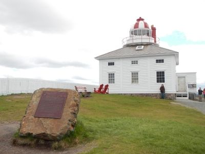
Cape Spear, Newfoundland’s oldest surviving lighthouse, has served as the chief approach light for St. John’s harbour since 1836. Constructed by local builders Nicholas Croke and William Parker, it consists of a stone towner . . . — — Map (db m79112) HM
English
In 1940, the American and Canadian Joint Board of Defence decided to protect the approaches to St. John’s harbour by installing heavy artillery at Cape Spear. Gun emplacements, magazines, and shelters were constructed by 1941 as . . . — — Map (db m79463) HM
Two plaques are mounted on this monument. English:
Near this site stood the “Mansion House” built between 1621 and 1625 by Captain E. Wynne, resident governor of the Colony of Avalon, for the proprietor, Sir . . . — — Map (db m79466) HM
A “Fishing Capital” and Colony
This was one of the first harbours in the New World to be frequented by European fishing ships. From the early 1500s The Pool was well known to the Portuguese, Spanish and French fleets. . . . — — Map (db m79471) HM
English:
This illustration depicts the burning of a house that once stood at this location and was excavated in the mid-1990s. The large stone fireplace foundation has been left as it was found. The rectangular depression marks the area . . . — — Map (db m79472) HM
English
Gaillardin Redoubt
Built originally of logs and subsequently of drywall masonry, this small enclosure surrounded by a breastwork was intended to keep an enemy from taking possession of Gaillardia Mountain, which overlooked . . . — — Map (db m78970) HM
English
In 1693 the French began construction of Fort Royal to guard the harbour at Placentia. When it was completed in 1703, several batteries and outworks supported the main fortifications. The defences, however, were precariously . . . — — Map (db m78917) HM
English
Welcome to
Castle Hill
National Historic Site of Canada
By 1600, France and England dominated the European migratory fisheries to Newfoundland. Small-scale English settlements began in 1610, and in 1662 France . . . — — Map (db m78919) HM
A fort consisting of a semi-circular redoubt mounting twelve guns, a guard house, barracks and storehouse surrounded by a palisade was erected on this site in 1721 and was named after H.R.H. Prince Frederick, then Prince of Wales.
Although the . . . — — Map (db m78918) HM
English
Built in the Vauban style, Fort Royal was designed to protect against attackers with siege artillery and muskets. It contains three demi-bastions and one full bastion. The overlapping faces of the demi-bastions form a flank that . . . — — Map (db m78935) HM
English
Fort Royal, 1709
Following an English naval attack on Plaisance in 1692 the French decided to erect a hilltop fortification to defend the town’s seaward approach. Fort Royal was begun the next year and completed around 1703. . . . — — Map (db m79009) HM
This memorial is dedicated
by
Canadian Marconi Company
to the government and people of Newfoundland to commemorate an outstanding event in the history of Newfoundland and a new era in world communications
The first transatlantic wireless . . . — — Map (db m78920) HM
This monument includes three panels outlining the history of the Royal Newfoundland Constabulary. Panel 1:
1729-1870 Policing in a Young Colony
Fishing Admiral Justice
The 15th century fishery off Newfoundland was primarily a . . . — — Map (db m79138) HM
Caption, bottom, left (English / French): The shaded area shows the extent of the 1892 fire. This was the last of several fires that shaped the development of St. John's in the 1800s. / La zone ombrée représente la partie de la ville ravagée . . . — — Map (db m79013) HM
This Italianate style building, Newfoundland’s first commercial bank building, constructed in 1849 to the design of Halifax architect David Stirling. The mansard roof was added in 1885. Burnt out and rebuilt after the 1892 fire, it retains a very . . . — — Map (db m79056) HM
English
This hill was the site of the decisive assault by British troops on the French lines, September 15, 1762, in the last phase of the battle in North America between the forces fo Great Britain and France. The victorious attack, led by . . . — — Map (db m78938) HM
Captions, clockwise from the top left. (English / French):
The Cabot Tower’s cornerstone was laid on 23 June 1897 to mark the 400th anniversary of John Cabot’s North American Landfall and the 60th year of Queen Victoria’s reign. The . . . — — Map (db m78971) HM
English
Two adjoining barracks were constructed on this site between 1837 and 1840. The two story complex stretched the length of the present parking lot. It was converted to stores in 1842 because of problems with smoke, cold and . . . — — Map (db m78936) HM
Captions, clockwise from the top right. (English / French):
St. John’s is both a fishing port and a supply base for the fleets of many countries. / Saint- Jean est à la fois un part de pêche et un centre d’approvisionnement pour les . . . — — Map (db m78972) HM
English
This Italianate style building recalls evolution of banking in Newfoundland, Designed by Halifax architect David Stirling for the Bank of British North America, it opened in 1850 at a time when British investors controlled banking . . . — — Map (db m79034) HM
English
This remarkable building served as the headquarters and terminus of the Newfoundland railway system. Begun in 1881, the railway played a significant role in the development of the island. Its benefits were evident by the eve of . . . — — Map (db m79109) HM
This plaque is dedicated to the memory of
Herbert J. Russell, C.B.E.
Mr. Russell began his carrer with the Newfoundland Railway on September 12, 1906, as an express messenger and stenographer. He rose quickly through various management . . . — — Map (db m79111) HM
Captions, clockwise from the top left. (English / French):Pack Ice, frozen sea water up to 70 cm (27in.) thick, can be present in the waters off St. John’s from February through April. The worst conditions occur in . . . — — Map (db m79011) HM
English
Educator, suffragist, and prominent nursing leader, Mary Southcott led the campaign to professionalize nursing in early 20th-century Newfoundland. Trained in London, England, she founded the St. John’s General Hospital School of . . . — — Map (db m79031) HM
Built to replace the Long’s Hill Temple destroyed by fire in 1892, the cornerstone of this building was laid by Sir William Whitewall on August 23, 1894. The Temple is the largest brick fraternal lodge in the province, and with its classical revival . . . — — Map (db m79057) HM
English
For at least 150 years, the arrival of noon hour in St. John’s has been announced by the firing of a gun on Signal Hill. It began as a military time signal, but the practice was continued by the colonial government after the British . . . — — Map (db m79012) HM
This building was constructed for Richard O’Dwyer, a prominent merchant from Waterford, to house his officies and retail stores, but also to accommodate other merchants. With its classically-detailed, granite block facade, the building would have . . . — — Map (db m79061) HM
Caption, top, left (English / French): The importance of Signal Hill to St. John’s goes beyond its guns, signal masts and hospitals. Poet, songwriters and artists alike have celebrated the Hill’s timeless strength. It has become a proud . . . — — Map (db m79014) HM
This plaque is dedicated to the memory of
Sir Robert Gillespie Reid
(1842-1908)
Sir Robert Gillespie Reid was a bridge builder and railway contractor of international fame. Many of the structures that he engineered throughout the United . . . — — Map (db m79110) HM
English
Begun in 1847, under the direction of Bishop Feild, this cathedral was designed by the noted British architect George Gilbert Scott and is an internationally important monument of the Gothic Revival style. Its historical . . . — — Map (db m79058) HM
English
The St. John’s Court House, built 1900-1094, is by far the most striking and elaborate courthouse in the province. Set into a steep hill it commands a dramatic view of the harbour. The Romanesque Revival building was designed by . . . — — Map (db m79032) HM
Captions, clockwise from the top right. (English / French):
Processing seal pelts, St. John’s around 1900. / Transformation des peaux de phoques, Saint-Jean vers 1900.
From 1793 to the early 1980’s, the departure of sealing ships . . . — — Map (db m78974) HM
Built after the 1846 fire, this structure housed a wide range of enterprises including Lash’s Bakery, the Railway Hotel, and McNamara and Thompson, both jewelers. Constructed with a timber frame, stone foundation and a brick exterior, it was among . . . — — Map (db m79059) HM
This marker is composed of two side-by-side plaques, one in English and the other in French. (English)At Signal Hill on 12 December 1901, Guglielmo Marconi and his assistant, George Kemp, confirmed the reception of the first . . . — — Map (db m78937) HM
English
Born in Scotland, Carson came to Newfoundland as a physician in 1808, and became an ardent advocate of social and political reform. He was leader in the campaign for an elected legislature, established in 1832, and helped bring . . . — — Map (db m79033) HM