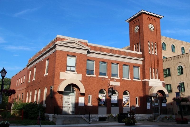
On Yonge Street 0.1 kilometers north of Mosley Street, on the right when traveling north.
Designed by the office of Dominion architect David Ewart, this building served as Aurora's post office from 1915 to 1968. It and its clock have long been focal points for community life. This building features a tower in the manner of an Italian . . . — — Map (db m196162) HM
On Wellington Street East at Wells Street, on the right when traveling west on Wellington Street East.
This house was built in 1886 by George W. Morrison, a prosperous carriage builder. It was acquired in 1919 by Jesse M. Walton, Aurora mayor, historian and businessman. An excellent example of late Victorian design, it features a symmetrical facade . . . — — Map (db m295153) HM
On Yonge Street at Maple Street, on the right when traveling south on Yonge Street.
The Hillary House grounds offer a modest residential landscape reflecting the casual interests and financial resources of its residents.
During the Victorian and Edwardian periods, leisure time became more prevalent for the upper and middle classes . . . — — Map (db m295156) HM
On Yonge Street at Maple Street, on the right when traveling south on Yonge Street.
Hillary House was designated a National Historic Site in 1973
as it represents one of the finest examples of Gothic Revival
architecture in Canada.
Popular throughout the western world by the mid 1800s, Gothic Revival architecture . . . — — Map (db m295244) HM
On Yonge Street at Maple street, on the right when traveling south on Yonge Street.
The people of Aurora were always welcome here at "The Manor”, as it was known during the time of the Hillarys. The property provided ample space for residents and visitors to enjoy, relax, and celebrate.
The Hillary family loved hosting outdoor . . . — — Map (db m295155) HM
On Mosley Street at Larmont Street when traveling east on Mosley Street.
Aurora Armoury
Built in 1874 as a drill shed for the 12th Battalion of Infantry or York Rangers, the Aurora Armoury was part of a network of defence training facilities for citizen soldiers. It evokes the larger stories and . . . — — Map (db m295141) HM
On Yonge Street at Wellington Street West, on the right when traveling south on Yonge Street.
Near this site stood Doan Hall, a substantial brick house built in 1855 by Charles Doan (1808-1895). To the south was Doan's general store, Charles Doan served as postmaster and in 1854 named this community "Aurora", after the goddess of the dawn. . . . — — Map (db m295379) HM
On Wellington Street East at Berczy Street, on the right when traveling east on Wellington Street East.
First Steam Train 1853
On May 16, 1853, the Ontario Simcoe and Huron Union
Railroad Company operated the first steam train in Canada West from Toronto to Machell's Corners (Aurora). The train
consisting of four passenger and . . . — — Map (db m295142) HM
On Yonge Street at Maple Street, on the right when traveling south on Yonge Street.
As the popularity of tennis grew in the early 1900s, a small group of Aurorans were determined to form a club of their own. On April 29,1911, the Aurora Lawn Tennis Club was formed. Originally located on the lawn adjacent to Trinity Anglican Church, . . . — — Map (db m295245) HM
On Yonge Street at Maple Street, on the right when traveling south on Yonge Street.
Built at the same time as the House and an important example of Gothic Revival
architecture in its own right, the Barn is fundamentally important in the history of the Hillary House property. In the 1800s and 1900s before hospitals, telephones, and . . . — — Map (db m295377) HM
On Yonge Street at Maple Street, on the left when traveling north on Yonge Street.
Since its initial construction in 1862 by Dr. Walter Geikie, Hillary House has undergone many additions and alterations. The house originally had a basic rectangular layout common for the time. On the main floor there was a room on either side of a . . . — — Map (db m295254) HM
On Yonge Street (Regional Road 1) at Catherine Avenue, on the right when traveling north on Yonge Street (Regional Road 1).
Yonge Street was opened between 1794 and 1796 under the direction of Lieutenant Governor John Graves Simcoe. Settlement along Yonge was encouraged as settlers were responsible for road maintenance. In 1797, the first patents, or Crown deeds, were . . . — — Map (db m255443) HM
On Mosley Street at Wells Street, on the right when traveling east on Mosley Street.
Purchased from John Mosley in 1867 the Town Park has been a focus of community activity for many years. At the northeast corner is the drill shed built in 1874 for the 12th Battalion, York Rangers. That same year, the Hon. Edward Blake delivered . . . — — Map (db m295091) HM
Near Yonge Street at Maple street, on the right when traveling south.
The beautiful and fertile land around Hillary
House has always supported the practical necessities of the family and offered a perfect area for outdoor activities. Dr. Robert Michael Hillary enjoyed tending to a large vegetable garden. The family . . . — — Map (db m295378) HM
On Leslie Street at Mount Albert Road, on the right when traveling south on Leslie Street.
Erected 1825-32, its architecture symbolizes the religious beliefs of its builder, David Willson, born in New York State 1778. Disowned by the Society of Friends (Quakers) he established hereabouts the Children of Peace (Davidites) in 1812, a small . . . — — Map (db m295489) HM
Canal Background
Known officially as the Holland River Diversion, this waterway was a proposed extension of the Trent Canal System from Lake Simcoe to Aurora by way of the East Branch of the Holland River. In 1904 an increase in freight rates . . . — — Map (db m295487) HM
On King Road 0.1 kilometers east of Jane Street, on the left when traveling east.
Built in 1852, King Station is believed to be the oldest surviving railway station in Canada. The station was originally located in Springhill (now King City) just 37 km north of Toronto and served passengers on the Ontario, Simcoe & Huron Union . . . — — Map (db m295028) HM
On King Road 0.1 kilometers east of James Street, on the left when traveling east.
In 1861, Kinghorn S.S. 23, a new one-room frame schoolhouse, was built on land purchased from James Burns. The new building replaced a log cabin, known as the "squatter's school", that had provided a space for lessons since 1847. Kinghorn was one . . . — — Map (db m295025) HM
On King Road 0.1 kilometers Jane Street, on the left when traveling east.
In 1856, Senator David Reesor donated land and the Sons of Temperance erected this hall which opened Jan. 1, 1859. From 1914-88, Laskay Women's Institute managed the building. In 1989 the hall was restored by the community supported
by the Twp. of . . . — — Map (db m295085) HM
On Yonge Street (York Regional Road 1) just south of Thornhill Summit Drive (Centre Street), on the right when traveling north.
Settlement began here after the opening of Yonge Street in the mid-1790s and by 1802 a grist mill and sawmill were operating on the Don River. The community developed slowly until 1829 when Benjamin Thorne built a large flour mill, tannery and . . . — — Map (db m255397) HM
On Main Street Unionville 0.2 kilometers south of Carlton Road, on the right when traveling north.
Founded in 1794 by William Berczy and his group of German settlers from Pennsylvania and New York, this village was officially named Unionville in 1849. Early activity centred around the mills, such as Stiver's, on the Rouge River to service the . . . — — Map (db m263442) HM
On Main Street Unionville at Fred Valley Drive, on the left when traveling north on Main Street Unionville.
In 1879, when the Congregational Church outgrew its frame church at 149 Main Street, this building was constructed on land donated by the Braithwaite family.
The building was designed by E.J. Lennox who later designed Toronto's Old City Hall . . . — — Map (db m263441) HM
On Markham Road (York Regional Road 68) 0.2 kilometers north of 16th Avenue (York Regional Road 73), on the left when traveling north.
The earliest settlers in this part of Markham Township, including several “Pennsylvania Dutch”, arrived on the Rouge River shortly after 1800. Within ten years Nicholas Miller had erected mills around which a community known as Markham Mills had . . . — — Map (db m254044) HM
On Water Street at Doug Duncan Drive, on the right when traveling north on Water Street.
Born Mazo Louise Roche in Newmarket, this celebrated Canadian writer attended the Ontario School of Art and the University of Toronto. She established an international literary reputation when her book "Jalna" won the Atlantic Monthly competition in . . . — — Map (db m295435) HM
On Yonge Street 0.3 kilometers north of Clearmeadow Boulevard, on the left when traveling north.
Meeting House of the Religious Society of Friends (Quakers) 1810
In 1800 an extensive grant of land in this vicinity was made to Timothy Rogers and Samuel Lundy who, with other members of the Religious Society of Friends . . . — — Map (db m295380) HM
On Queen Street at Charles Street, on the right when traveling west on Queen Street.
One of the earliest reinforced concrete arches in Canada, the Newmarket radial railway arch was built in 1909 by the Toronto and York Radial Railway Company. It was designed by Barber and Young, an innovative civil engineering firm, and supported . . . — — Map (db m295471) HM
On Eagle Street 1 kilometer Yonge Street, on the left when traveling east.
This cemetery came into use in the early 19th century as a non-
denominational burying ground, but in 1863 ownership passed
to St. Paul's Anglican Church. Prominent pioneers buried here
include William Roe (1795-1879), a town founder, Dr. . . . — — Map (db m295432) HM
On Water Street at Main Stteet, on the right when traveling east on Water Street.
In 1801 Joseph Hill, attracted by the water-power potential of the Holland River, built a grist mill on the site of present-day Newmarket and opened a general store. The settlement here in 1803-1804 of Elisha Beman, a major local landowner and . . . — — Map (db m295469) HM
On Bernhardt Road 0.1 kilometers east of Dufferin Street, on the right when traveling east.
The Holland Marsh consists of 7000 acres of reclaimed land in the Schomberg River Valley. Named after an early provincial official, this fertile area was drained between 1925 and 1930. John Snor, Canadian Representative of the Netherlands Emigration . . . — — Map (db m295452) HM
On Yonge Street 0.3 kilometers south of Stouffville Road, on the right when traveling north.
In the fall of 1798 some 40 exiled French Royalists. under the leadership of Joseph-Genevieve, Comte de Puisaye (1754-1827), emigrated from England to Upper Canada. The following year they were given rations and agricultural implements and settled . . . — — Map (db m295090) HM
On Yonge Street, on the right when traveling south.
Settlers came to this district about 1794 after the construction
of Yonge Street north from York (Toronto). The settlement
prospered as a way station for travellers. Known as Mount
Pleasant, the community was renamed, following a . . . — — Map (db m235928) HM
On Yonge Street (York Regional Road 1) just north of Townwood Drive, on the right when traveling north.
[English] This highway was planned by the first governor of Upper Canada, John Graves Simcoe, as a military and commercial route between Lakes Ontario and Huron. Begun in 1795 by the Queen's Rangers it was cut through to Lake . . . — — Map (db m254281) HM
On Rebellion Way at Little Rebel Lane, on the left when traveling north on Rebellion Way.
In 1832 Jesse Lloyd, a Quaker who had come from Pennsylvania to Upper Canada about 1812, purchased 60 acres of land in this vicinity. During the following years he sold portions of his property to incoming settlers. The erection of a grist-mill, . . . — — Map (db m295589) HM
Near Canada's Wonderland Drive near Jane Street (Route 55).
The "Antique Carrousel" was manufactured in 1928 by Philadelphia Toboggan Company (PTC) with four rows which house 84 horses and two chariots. The company produced a total of 75 original carrousels and 19 refurbished carrousels in the first four . . . — — Map (db m306325) HM
On Canada's Wonderland Drive near Jane Street (Route 55).
Since opening in 1981, the Mighty Canadian Minebuster has delivered thrills to millions of guests and remains one of Canada's Wonderland's most iconic attractions. Through the dedication and craftsmanship of Canada's Wonderland's carpenters, the . . . — — Map (db m306326) HM
On Keele Street 0.8 kilometers north of Langstaff Road, on the right when traveling north.
In December, 1806, a group of German settlers from Berlin, Pennsylvania, led by Jacob and Michael Keffer, arrived in Vaughan Township, where they formed one of Upper Canadas earliest Lutheran congregations. Their first services were conducted by the . . . — — Map (db m294979) HM
On Keele Street 0.1 kilometers south of Major MacKenzie Drive, on the left when traveling south.
Originally owned by one of Vaughan's pioneer families, The McQuarrie Family. Lachlan McQuarrie brought his family to Maple in 1829 from New York City where he raised his three girls and five boys. After the deaths of Mr. & Mrs. McQuarrie, the . . . — — Map (db m294984) HM
On Keele Street at Major MacKenzie Drive, on the right when traveling north on Keele Street.
One of the Commonwealth's best-known publishers, politicians and philanthropists, William Maxwell Aitken was born in Maple. The son of the Reverend William Aitken, a Presbyterian minister, he was educated in Newcastle, New Brunswick, to which his . . . — — Map (db m295008) HM
On Keele Street 0.4 kilometers south of Major MacKenzie Drive, on the right when traveling south.
A superb example of "carpenter's Gothic" architecture, this building was constructed to serve a Church of Scotland congregation organized about 1829. It was built during the rectorship of the Rev. Donald Ross by John McDonald, a local contractor, . . . — — Map (db m294981) HM
On Teston Road near Jane Street, on the right when traveling east.
Town of Vaughn
Formerly Township of Vaughn
1850-1970
Sometime between 1847 and 1852 an Englishman, named Thane, emigrated to Canada from Heyshaw, Lancashire. He built a home for himself in the village which was then called . . . — — Map (db m295023) HM
On Brooke Street just south of Old Jane Street, on the right when traveling south.
Holy Trinity Church was built on the west side of Yonge Street at Royal Orchard Boulevard in 1830 by a congregation that had worshipped since 1815 at nearby Cober schoolhouse. The entire building was dismantled and rebuilt on this site in 1950. . . . — — Map (db m255399) HM
On Centre Street at Thornbank Road, on the right when traveling east on Centre Street.
MacDonald, one of Canada's outstanding artists, lived here 1913-1932. Born in Durham, England, of Canadian parents, he came with his family to Hamilton in 1887. Though his formal art training was limited, he became one of the founders of the “Group . . . — — Map (db m255398) HM
On Yonge Street (Regional Road 1) at Centre Street, on the right when traveling south on Yonge Street (Regional Road 1).
Mason Cogswell's Wagonyard Mason Cogswell (1818-1893) operated a wagonyard at this corner c. 1850. Wagon and barrel making were two main industries associated with a milling-agricultural village. It was not uncommon to see wagons . . . — — Map (db m255491) HM
Near Centre Street at Thornbank Road, on the right when traveling east.
Thoreau MacDonald’s namesake was Henry David Thoreau, philosopher, naturalist and author of Walden Pond. “It is hard to realize how close we are to pioneer times, that people still living remember the days of clearing land; water . . . — — Map (db m309281) HM
On Centre Street at Yonge Street (Regional Road 1), on the right when traveling east on Centre Street.
The Stirling Bank, 1917-1967 Prior to 1917, banking services, primarily to local farmers, were available at a smaller bank located just south of here in the centre store of the Francis block. In 1928 the Stirling Bank became the . . . — — Map (db m274300) HM