629 entries match your criteria. The first 100 are listed. Next 100 ⊳
Works Progress Administration (WPA) projects Historical Markers
Markers related to public works built through or associated with the Works Progress Administration, or WPA, the Great Depression-era U.S. Federal government agency which provided jobs for millions of Americans.
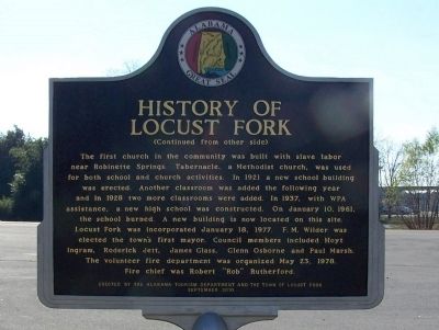
While traveling south with his troops, General Andrew Jackson camped at the fork of the river in 1813. General Jackson carved his name in a locust tree naming this area Locust Fork. In 1817, the Hanby family came from Virginia and settled in this . . . — — Map (db m50125) HM
History of the Library
In 1913 the Study Club of Andalusia was organized to establish a library for Andalusia. Led by founder Miss Ethel Darling the club held a book shower
resulting in $5.50 and 15 books which became the embryo of the . . . — — Map (db m129389) HM
Through the efforts of local citizens, Benny Dean and Floyd Beddingfield, the City of Gadsden obtained this facility from American Legion Post Number 5 in 1985. Built in 1935, the amphitheater seats 1600 persons. Designed by local architect, Paul W. . . . — — Map (db m83736) HM
Built of local sandstone in 1935 on land obtained from the American Legion Post No. 5 this municipal amphitheatre seating about 1600 was constructed for staging theatrical and sporting events. Gadsden architect Paul W. Hofferbert designed the . . . — — Map (db m39140) HM
Side 1 - Building the Park
In the mid-1930’s, civic leaders worked to move Vulcan to a place of honor on Red Mountain. The park was built through the combined efforts of several groups: the Kiwanis Club of Birmingham, the Birmingham Parks . . . — — Map (db m83807) HM
The WPA (Works Progress Administration) funded the design and construction of Vulcan Park in the late 1930s. This was done in conjunction with the Alabama Highway Department’s improvement of U.S. Highway 31, the major north/south route that runs . . . — — Map (db m69022) HM
In 1822 William Pullen, Revolutionary War veteran, acquired this land from the Federal Government for farming. In 1889 his heirs sold the land to the City of Birmingham for use as the New Southside Cemetery which operated from 1889 to 1909 with . . . — — Map (db m27096) HM
Built 1936-37 Following a fire in 1932 that destroyed a 19th century City Hall, architect Frank Lockwood designed a replacement for the same site. With the Depression affecting all construction projects during the period, the city received . . . — — Map (db m36571) HM
"This section lying between Sixth Avenue and Eighth Avenue will provide the central beautification theme as it will evolve into a beautiful elevated rose garden with 2,000 selected roses planted at vantage points… the color ensemble, . . . — — Map (db m279728) HM
Born in 1894 in Normandy, Tennessee, Carolyn Cortner was raised in the Courtland area of Lawrence County, Alabama. She attended Ward-Belmont College in Tennessee. She married Wilburn Smith in 1912. She did not attend formal architecture school . . . — — Map (db m27814) HM
Known as the Alabama College Laboratory School, Montevallo High School was housed in Reynolds’ Hall on the University of Montevallo campus from 1922 until January 1930 when the central portion of this building was completed. The original structure . . . — — Map (db m37428) HM
Home of the University of Montevallo, American Village and the Alabama Veterans Cemetery, Montevallo is located in the geographical center of Alabama at 33° 6’ 18” N 86° 51’ 46” W. In 1814, Jesse Wilson laid claim to “Wilson’s . . . — — Map (db m37178) HM
In 1926, the City of Tuscaloosa purchased a 31-acre tract of land that would become Queen City Park. Amenities were added utilizing funds from President Roosevelt's Civil Works Administration (CWA) and Works Project Administration (WPA). Some of the . . . — — Map (db m203568) HM
Built during the great depression using native stone & W.P.A. labor, this twenty-bed facility finally opened in 1939 when a doctor agreed to come to Round Valley to finish, lease & run the hospital for 10 years. — — Map (db m36649) HM
Originally constructed of wood in 1908, the Warren Ball Park is the oldest in the state of Arizona and stands as testimony to Bisbee's rich heritage. The Warren Company, a subsidiary of the Calumet & Arizona and Pittsburgh & Superior Mining . . . — — Map (db m48573) HM
Was constructed by P. Howard Pregenzer and crew
In Memory of
P. Howard Pregenzer
1894-1980
Resident of Willcox, Arizona 1927-1980
Construction began in 1934 and completed in 1936
Construction sponsored by the City of Willcox, . . . — — Map (db m28415) HM
The military use of Papago Park began in 1909 when the northwest corner of the Park was withdrawn from the public domain for military purposes. This area was used by the 158th Infantry Regiment of the First Arizona Volunteer Infantry (National . . . — — Map (db m87962) HM
Since 1908, the area of Prescott now known as Ken Lindley Field has been used as a public park and ballfield. The land was deeded to the City of Prescott by Charles T. and Ada M. Joslin in 1922. As Mrs. Joslin requested, the City later . . . — — Map (db m21161) HM
There was a time when progress in Yavapai County was spelled S-P-A-R-K-E-S. Grace M. Sparkes came to Prescott, Arizona Territory, at the age of 14 in 1906. By 1911, she was working for the Yavapai County Chamber of Commerce as Secretary, a job she . . . — — Map (db m33137) HM
Prescott was one of the first towns in Arizona to have a National Guard Unit. Companies B and C of the First Territorial Rifles were organized in Prescott in 1865 and Company M of the First Arizona Infantry was organized in 1910. Company M of the . . . — — Map (db m33136) HM
The Works Progress Administration built this building, dedicated on May 29, 1936, as a new post office. The structure served the citizens of Osceola and the Cotton Highway as a post office until the Postal Service relocated to Johnson Street. . . . — — Map (db m36616) HM
Jasper, the county seat of Newton County, was designated as such soon after the creation of the county, December 14, 1842. It was named in honor of Thomas W. Newton. — — Map (db m155497) HM
From Predators to Patrons
This historic Works Progress Administration (WPA) building
constructed in 1934 once housed majestic big cats,
including lions, tigers, and jaguars. Though these animals
have moved to modern habitats better suited . . . — — Map (db m288195) HM
Businesses flourished on Main Street after the turn of the century. In 1901 the Bank of Waldron and First National Bank both opened on South Main Street. By 1902 the Kansas City Southern Railroad went through Waldron, making it an important . . . — — Map (db m262791) HM
In 1905, after several previous courthouses had burned down in Waldron, another was commissioned. The new courthouse would also be accompanied by a new jail in 1907. The new jail was to be built of stone unlike its wooden predecessor. J.L. . . . — — Map (db m262762) HM
City of Berkeley Landmark
Designated in 2001
North Branch Berkeley Public Library
James W. Plachek, Architect, 1936
North Branch Library is one of Berkeley’s many civic buildings by James Plachek, including the Central Library (1930), . . . — — Map (db m15868) HM
The Rose Garden was a joint creation of the City of Berkeley and the Federal Works Progress Administration (WPA), whose public works provided employment during the Depression. Vernon M. Dean, the City's landscape architect, designed the garden in a . . . — — Map (db m18618) HM
Welcome to the Morcom Amphitheater of Roses,
originally the Morcom Rose Garden. This Jean Street
entrance is wheelchair accessible. This map uses icons to indicate such accessible features, including the Sensory Garden.
The Morcom Amphitheater . . . — — Map (db m157307) HM
Joaquin Miller Park was formed in 1917 when the City of Oakland and its citizens – led by The California Writers Club – purchased 68 acres from the estate of Joaquin Miller, the noted 19th century “Poet of the Sierras” and . . . — — Map (db m71737) HM
Alvarado Park (Grand Canyon Park) was established
in 1909 and soon became a popular destination for
visitors from throughout the Bay Area. From the mid-1930s to 1943 Richmond installed the park's rock and
concrete walls, barbecue pits, and stone . . . — — Map (db m146005) HM
A Popular Gathering Place for 200 Years
Alvarado Park has long been a popular spot to gather.
Native Americans lived here and ground acorns on the
site. Later, Spanish settlers came to picnic at what they
called Arroyo Cañada (stream . . . — — Map (db m146445) HM
Historical buildings,
Arvin Farm Labor
Supply Center,
Sunset Government Camp.
From the people of
Oklahoma — the Okies —
who found a home here
and helped build California.
-Gov Frank Keating, 2002. — — Map (db m309817) HM
Constructed on the basic plan of Sutter’s original fort one hundred years after its erection in Sacramento by that distinguished pioneer Captain John Augustus Sutter. The building of this replica of one of the most outstanding landmarks to the early . . . — — Map (db m130655) HM
marker at amphitheater:
Built by
United States
Works Progress
Administration -
1938.
marker at basketball courts:
Improved by
Works Progress
Administration -
1937. — — Map (db m243384) HM
Federal Emergency Administration of Public Works.
John M. Garmody, Administrator of Public Works.
Franklin D. Roosevelt, President of the United States.
Beverly Hills High School, 1939. — — Map (db m183132) HM
Burbank City Hall - April 18, 1996.
This Property has been placed on the National Register of Historic Places by the United States Department of the Interior. — — Map (db m55763) HM
On this site American Legion Post 288 once stood. The great flood swept through its walls shortly after midnight on New Year’s Day, taking with it 12 local residents. Most had taken refuge inside from the torrential rain and two were dedicated Red . . . — — Map (db m143027) HM
In 1984 a Red Oak tree in front of La Verne Heights Elementary School became diseased. Tree limbs began to fall off onto Baseline Road, creating hazards for drivers as well as students of the elementary school. Recognizing the potential danger, . . . — — Map (db m190868) HM
This mosaic tile mural, one of the largest in the world with more than 466,000 California tiles, was created by dozens of artists as a W.P.A. Federal Arts Project in 1937 to grace the facade of the Municipal Auditorium. It was saved from demolition . . . — — Map (db m72453) HM
Long Beach was a center for early aviation, and established the first municipal airport in Southern California here in 1924. It was originally named "Daugherty Field" for aviation pioneer Earl S. Daugherty, who had a flying school nearby and who . . . — — Map (db m189652) HM
Federal Works Agency,
Public Works Administration.
John M. Carmody,
Federal Works Administrator.
Franklin D. Roosevelt,
President of the United States.
Barham Blvd Bridge
over Cahuenga Blvd,
1940. — — Map (db m227121) HM
Federal Emergency
Administration
of Public Works.
Franklin D. Roosevelt,
President of the United States.
Harold L. Ickes,
Administrator of Public Works.
1939. — — Map (db m226444) HM
Owensmouth and the West Valley area were served
by two post offices since 1912. In 1931, Owensmouth
became Canoga Park and it was decided to build a
permanent office for the area. This Canoga Park
post office opened in 1939 and is said . . . — — Map (db m211194) HM
Federal Emergency Administration
of Public Works Project No. 4361.
City of Los Angeles, Frank L Shaw - Mayor.
Board of Public Works...
Bureau of Engineering...
Members of the City Council...
General contractor: . . . — — Map (db m229670) HM
Federal Emergency Administration
of Public Works Project No. 4561.
City of Los Angeles, Frank L Shaw - Mayor.
Board of Public Works...
Bureau of Engineering...
Members of the City Council...
General contractor: Bent . . . — — Map (db m229107) HM
Federal Works Agency,
Public Works Administration.
John M. Carmody,
Public Works Administrator.
Franklin D. Roosevelt,
President of the United States.
Temple Street Grade Separation,
1939. — — Map (db m229200) HM
This property has been
placed on the National Register
of Historic Places by the United States Department of the Interior.
Henry Morgenthau Jr,
Secretary of the Treasury.
James A Farley,
Postmaster General.
Louis A Simon, . . . — — Map (db m305185) HM
Fondly known as “Lady of the Lake”,
by Ada May Sharpless.
Erected by the Federal Art Project 1934-1935.
Conserved by the City of Los Angeles Cultural Affairs Department,
with support from Councilmember Jackie Goldberg,
the . . . — — Map (db m229144) HM
Designed as the largest enclosed structure without columns in the world by noted California architects Robert Clements & Associates, this Art Deco building, constructed between 1938 and 1941 by the WPA, is the largest and second-oldest Navy Reserve . . . — — Map (db m147662) HM
Built by United States Work Projects Administration, 1940.
second marker:
Exact Center - City of Los Angeles
Point of balance of the plane of the City of Los Angeles, Lat. 34°07'31"N, Long. 118°23'57"W, Alt. 920 ft, . . . — — Map (db m199910) HM
Federal Emergency Administration
of Public Works.
Franklin D. Roosevelt,
President of the United States.
Harold L. Iickes, Administrator of Public Works, 1939. — — Map (db m229521) HM
This plaque is placed to commemorate the centennial
anniversary of golf in Griffith Park. The oldest 18-hole
municipal course West of the Rockies, the original course
opened for play in 1914. It was a model of city course
stewardship and . . . — — Map (db m165741) HM
A Dangerous Bottleneck
Prior to the Riverside Drive Bridge that you see today, there was once a wooden structure crossing the Los Angeles River in its place. However, this old wooden bridge was inadequate to serve the increasing . . . — — Map (db m223397) HM
Originally known as the Victory Boulevard bridge, the Riverside Drive bridge was constructed in 1938 to improve a bottleneck caused by an earlier wooden bridge. It was partially funded by President Franklin D. Roosevelt’s Works Progress . . . — — Map (db m129133) HM
This area served as the City's Zoo from its founding in 1912 until 1965, when the Los Angeles Zoo moved to its current
location about two miles north of where you are currently standing.
Many of the walls, grottos, and enclosures you see . . . — — Map (db m239129) HM
A 15-foot high granite statue of the Muse of Music welcomes visitors to the Bowl.
The fountain was designed by George Stanley, the sculptor of the Oscar. The fountain was built in 1940 by the County of Los Angeles Engineer's Department . . . — — Map (db m283525) HM
Built by
United States
Work Projects
Administration,
1940.
Fire Station No. 1,
Streamline Moderne style. Architects — Public Works Administration.
Built 1940. Declared 1976, Historic-Cultural Monument No. 156, City of Los Angeles, . . . — — Map (db m134911) HM
Federal Emergency Administration
of Public Works,
Franklin D. Roosevelt,
President of the United States.
Harold L. Ickes, Administrator of Public Works.
1939. — — Map (db m229134) HM
Federal Emergency
Administration of Public Works,
Franklin D. Roosevelt,
President of the United States,
Harold L. Ickes,
Administrator of Public Works,
1939. — — Map (db m229199) HM
This building was
erected during the
administration of
Franklin D Roosevelt,
President of the United States
of America.
Henry Morgenthau Jr,
Secretary of the Treasury.
James A Farley,
Postmaster General.
Christian Joy . . . — — Map (db m224665) HM
Federal Emergency
Administration of Public Works.
Franklin D. Roosevelt,
President of the United States.
Harold L. Iickes,
Administrator of Public Works.
1939.
The Patriot Tree
Planted in remembrance of . . . — — Map (db m257823) HM
Federal Emergency
Administration of Public Works.
Franklin D. Roosevelt,
President of the United States.
Harold L. Ickes,
Administrator of Public Works.
1939.
Roscoe
Elementary School,
a Learn school since 1993. — — Map (db m177337) HM
Federal Emergency Administration
of Public Works.
Franklin D. Roosevelt, President of the United States.
Harold L. Ickes, Administrator of Public Works.
City of Los Angeles
Fire Department
Engine Co. 39, erected 1939. — — Map (db m227108) HM
The 1st Street Viaduct over Glendale Boulevard is a
reinforced concrete bridge with a box girder design
constructed between 1940 and 1942. Designed by the
City of Los Angeles Bureau of Engineering, the viaduct
has Moderne-style architectural . . . — — Map (db m235247) HM
National Home
In 1887, the U.S. Congress approved funding for the Pacific
Branch of the National Home for Disabled Volunteer Soldiers
(NHDVS). Three individuals donated land for the 640-acre
site located 14 miles west of Los . . . — — Map (db m219686) HM
Visionaries Make a Dream Into Reality
"What could be more interesting and educational, to the people
at large, than a public park devoted to plants indigenous to our
dry and semi-arid lands..." -Ralph D. Cornell
Washington . . . — — Map (db m243307) HM
Dedicated
September 19, 1994,
in honor of Millard Sheets,
who dedicated 25 years
of service to
the Los Angeles County Fair as
director of Fine Arts
from 1931 to 1956.
Through his life-long efforts
and enthusiasm, Sheets, an
internationally . . . — — Map (db m218586) HM
City Hall was built in 1938 from a plan by architects Donald B. Parkinson and J.M. Estep in the Classical/Moderne style. Commissioned under the Federal Emergency Administration of the Public Works Program, the design is exemplary of the many New . . . — — Map (db m128854) HM
Federal Emergency Administration of Public Works.
Franklin D. Roosevelt, President of the United States.
Harold L. Ickes, Administrator of Public Works.
Colorado Avenue Viaduct - 1939. — — Map (db m250275) HM
Offering its first courses on September 25, 1913 to 28 students, Fullerton College is the oldest community college in continuous operation in California. All the college classes were held in the Fullerton High School facilities until 1937 when the . . . — — Map (db m50001) HM
Built by United States Work Projects Administration, 1941.
City of Fullerton Local Landmark No. 11, Fullerton Library, built 1941.
Plaque placed by Fullerton Heritage, 2002. — — Map (db m235009) HM
Kiosk Side A:
Creating Jobs and Building Community
It started as an ”unsightly maze and tangle of briars, brush and junk”… It became ”one of the finest open air amphitheaters in northern . . . — — Map (db m52855) HM
Spanish explorer Don Juan Bautista de Anza is the first European known to visit the area now known as Riverside. He passed through this region in 1774 and again in 1775-76 while seeking an overland roote from Sonora Mexico to the San Francisco . . . — — Map (db m304231) HM
Central School was founded in 1887 and was Ontario’s first public
school. This is the third school building on this site and was
designed by Harry L. Pierce. It was built in 1934 as a WPA project.
It is one of the finest examples of Art Deco . . . — — Map (db m161078) HM
The Mediterranean Revival building with Italian Villa styling was built in 1937 as part of the Works Project Administration (WPA). Designed by DeWitt Mitcham, the building served as City Hall until 1979. It was built on the site of the Ontario . . . — — Map (db m288343) HM
Constructed in 1935 at a cost of $30,000, and was a WPA project.
The ball park was the spring training home of Los Angeles Angels of
the Pacific Coast League from 1937 until 1942. The first game was
played on March 14, 1937 between the Angels . . . — — Map (db m252129) HM
The Downtown Post Office was designed in a modern Spanish Revival architectural style by Los Angeles architect, Louis A. Simon, and constructed with funds from the Works Progress Administration (WPA). There are two vividly-colored murals in the . . . — — Map (db m288194) HM
This branch of San Gabriel Mission was constructed about 1830 on the San Bernardino Rancho. During the 1840's, its buildings were used by José del Carmen Lugo as part of his rancho grant. Later, after its sale to the Mormons, it was occupied by . . . — — Map (db m131701) HM
Hurriedly built in two months by the Works Progress Administration (WPA) for $25,000 in 1936, this wooden, green painted and later termite-infested ballpark was the original home of the Pacific Coast League (PCL) San Diego Padres. The breeze that . . . — — Map (db m83871) HM
Originally built as the home of San Diego’s John Brown in 1850, the house was converted to a church by Don Jose Aguirre in 1858. Father Antonio D. Ubach , formally a missionary among the Indians, was parish priest here from 1866 to 1907. It is said . . . — — Map (db m11652) HM
No. 7
Dedicated
in commemoration
the heroic sacrifice and
history-making achievements
of the
Mormon Battalion
"whose march over 2000 miles
from Council Bluffs, Iowa to San Diego
help to win California for the Union
and open a . . . — — Map (db m51992) HM
National Cemeteries for
World War Veterans
The U.S. Army managed the National
Cemetery System until its transfer to what
is now the Department of Veterans Affairs
(VA) in 1973. It established cemeteries out
of necessity during . . . — — Map (db m295573) HM
This historic building, completed in 1939 as the
Aquatic Park Bathhouse, is named in honor of
U.S. Representative Sala Burton (1925-1987).
In recognition of her commitment to important
progressive causes, protecting the environment . . . — — Map (db m259535) HM
The Presidio began expanding just before the United States entered World War II. Buildings 38 and 39 were built by the Works Progress Administration (WPA) in 1940 to provide housing and to create employment during the Great Depression. Each . . . — — Map (db m176597) HM
The present Los Baños del Mar Pool represents the third public
facility to be situated in the Plaza del Mar Park area. In November
1899, the bathhouse site property was deeded to the Santa Barbara
County Chamber of Commerce through the probate . . . — — Map (db m167411) HM
This beautiful building was designed by Ralph Wyckoff to house San José’s Main Post Office. It was built as a W.P.A. project in 1933 and is a prime example of Depression-Era federal construction. The terra cotta work on the building’s exterior is . . . — — Map (db m30091) HM
Dedicated Memorial Day 1939
Owner: County of Shasta
Maintained by War Veterans of Shasta County
General Contractor: Adam Arras & Son Contractors
Funded by The County of Shasta and WPA
Listed in Architectural Historian Book By David Gebhard . . . — — Map (db m113330) WM
629 entries matched your criteria. The first 100 are listed above. Next 100 ⊳