The Southern Pacific was an American Class I railroad that existed from 1865 to 1996 and operated in the Western United States. In 1995 it became part of the Union Pacific Railroad.
The railroad reached Tucson in March of 1880. Richard Grid had a railroad spike crafted of solid silver from the Toughnut Mine. It was presented to the President of the Southern Pacific Railroad as an inducement to bring a railroad spur to . . . — — Map (db m53401) HM
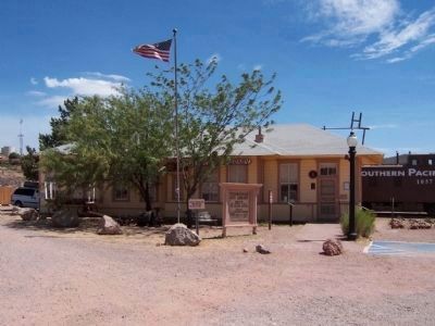
This is the only remaining original redwood frame Southern Pacific R.R. Station in Arizona. It is also the only known, original, on site, passenger depot still extant on the Southern – Trans – Continental Railroad route, between Los . . . — — Map (db m28180) HM
The S.P.R.R., building the nation's second transcontinental rail line eastward from California, reached Tucson on March 20, 1880. It was the occasion for one of the greatest celebrations in the history of the city and foretold the coming of a new . . . — — Map (db m83229) HM
The New Mexico and Arizona Railroad which served Patagonia, was built by the Santa Fe in 1881-82 and was operated after 1897 by the Southern Pacific. The last portion of this line, terminating at Patagonia, was abandoned in 1962.
The Patagonia . . . — — Map (db m24108) HM
Tassajara Creek Regional Trail
Tassajara Creek/Ridge Trail
(5.54 Miles): This unpaved and paved regional trail extends from the lowlands of Tassajara Creek in Alameda County to the ridgeline above Dougherty Valley in Contra Costa . . . — — Map (db m204577) HM
This railroad station having been located about half a mile west of the old town of Laddsville, on land owned by Wm. M. Mendenhall. Established the location of the town Livermore. The first depot was a freight car that was soon replaced by a . . . — — Map (db m194530) HM
First located here April 28, 1876 by Central Pacific R.R. First passenger train passed through on September 25, 1877 with Leland Stanford aboard.
Historic Marker No. VI
Martinez Historical Society
July 4, 1991 — — Map (db m19225) HM
The first passenger train rolled into Walnut Creek in 1891. Southern Pacific built the train depot later that year on a site that was across the creek (now under Broadway) and close to this plaza. The depot was converted to commercial uses and . . . — — Map (db m93738) HM
Originally, in the late 1800's Kerman was called "Collis" in honor of the Southern Pacific Railroad President at the time, Collis P. Huntington. The Southern Pacific Railroad line was built through Kerman in 1891. The name was changed to Kerman in . . . — — Map (db m229450) HM
Approximately 3,000 men labored on railroad construction up and over the Tehachapi Mountains in the 1870s.
It took over three years for the line to be completed through Kern County. As the railroad slowly progressed through the county, . . . — — Map (db m25606) HM
From this spot may be seen a portion of the world-renowned “Loop.” It was completed in 1876 under the direction of William Hood, Southern Pacific Railroad Engineer. In gaining elevation around central hill of loop a 4000 foot train will cross 77 . . . — — Map (db m134430) HM
Constructed by the Southern Pacific, Santa Fe and Union Pacific Railroads, opened on May 7, 1939. It was considered to be the most impressive railroad station of its type in the entire west.
In it's heyday the terminal covered 52 acres, . . . — — Map (db m171705) HM
The Southern Pacific Railroad constructed a station just
west of Cataract Avenue at the crossing in 1895. The depot
had living quarters above the offices for the station agent.
Mr. Tom Gore and his family lived in the station and was
agent for . . . — — Map (db m168915) HM
On September 5, 1876, Charles Crocker, President of the Southern Pacific Company, drove a gold spike here to complete his company's San Joaquin Valley Line, the first rail connection of Los Angeles with San Francisco and Transcontinental lines. — — Map (db m122365) HM
On this exact site (or hereabouts) 100 years ago, Clamper Charles Crocker drove a spike of pure California gold, completing the Southern Pacific Railroad link between San Francisco & Los Angeles, Queen of Counties. — — Map (db m133821) HM
Southern Pacific Railroad
Prior to 1912, there was no SP depot located in Chowchilla. The nearest depot was in Minturn, six miles to the north. Land developer O.A. Robertson bought the Chowchilla Ranch in 1912, and began selling parcels . . . — — Map (db m197167) HM
Southern Pacific Railroad - Before the townsite was created the train stopped at Minturn. Chowchilla was known as McNears Crossing. After it was founded the company moved the train station to a site just south of Robertson Blvd. Twenty . . . — — Map (db m242668) HM
In the early 1900s a decision by Southern Pacific Railroad to relocate the regional operations to this area helped turn a small town once known as Junction into the City of Roseville. Locomotive 2252 is a symbol of this history and of the social and . . . — — Map (db m37150) HM
In 1852, shortly after the Gold Rush, forward-thinking businessmen led by Charles Wilson incorporated the Sacramento Valley Railroad (SVRR), the first railroad west of Missouri. Wilson hired 28-year old Theodore Judah to design the alignment which . . . — — Map (db m214498) HM
Four of the most successful merchants in Sacramento specialized in hardware, dry goods, and groceries. Later known as the “Big Four,” Charles Crocker, Mark Hopkins, Collis P. Huntington, and Leland Stanford banded together to convince the United . . . — — Map (db m229817) HM
Southern Pacific Railroad Depot
Oceano, California
1896 - 1973
The Oceano Depot served as a focal point for transportation, tourism & real estate promotion in the South County from 1896 until the 1950's. The existing structure, a "Combination . . . — — Map (db m103009) HM
The historic Southern Pacific Water Tower is located directly across the tracks from where you are standing. It looks much as it did when built in 1940 at a cost of $2,130. The Water Tower is located in it original position, across from the City’s . . . — — Map (db m70050) HM
Transportation has evolved along with the city of South San Francisco. As farms and cattle ranches became manufacturing communities, walking trail gave way to road, stagecoach to car, fishing pier to deep water port. In 1904 when the Bayshore . . . — — Map (db m206508) HM
On this site stands Goleta Depot, an enduring tribute to many who, with generous gifts of love, time, and resources made possible its acquisition, restoration, and maintenance as Santa Barbara County Landmark No. 22.
Built in 1901 near South . . . — — Map (db m176316) HM
The Southern Pacific Railroad erected this handsome building in 1905 to serve the growing Santa Barbara community and its resort hotels. The architect was Francis W. Wilson of Santa Barbara. Designed in the Mission Revival style, the station has . . . — — Map (db m200307) HM
This property was the site for two locomotive roundhouses constructed by the Southern Pacific Railroad. The first stood between 1911 and 1925, when the June 25, 1929, earthquake severely damaged it. Miss Pearl Chase, of the Plans and Planting . . . — — Map (db m147913) HM
This locomotive was built in 1914 by Lima Locomotive Works and was famous for its colors, as well as for pulling the Coast Daylight Trains 98 and 99, which carried passengers from San Francisco to Los Angeles along the scenic coast of California in . . . — — Map (db m230533) HM
The town of Los Altos as we know it owes its existence to the Southern Pacific Railroad. Needing a shortcut between Palo Alto and Los Gatos, the Southern Pacific Railroad acquired the downtown "triangle" in 1907 from Sarah Winchester, who refused to . . . — — Map (db m100299) HM
Dedicated to the memory of
all the patriotic men and women
who answered their country’s call to service.
George W. Bush
President of the United States
R. James Nicholson
Secretary
U.S. Department of Veterans Affairs . . . — — Map (db m36827) HM
Valley of the Moon is a translation of Sonoma Valley's name given by the Pomo and Coast Miwok peoples, the area's original inhabitants.
Many writers and artists have found creativity here. Mary Francis Kennedy (MFK Fisher), excited by the . . . — — Map (db m231586) HM
Southern Pacific Railroad Passenger Depot originally completed 1915.
Transportation Center Dedicated December 10, 1993
Modesto City Council
Richard A. Lang, Mayor • David E.Cogdill, Vice-Mayor • Charles V. Bird • Stan Dobbs • Kenni Friedman . . . — — Map (db m197394) HM
By July 1872 the railroad had reached a site where they had planned a town to be called
"Tulare City". This they believed, by bypassing Visalia, would soon become the new county seat and a large area was allowed for the government buildings, but . . . — — Map (db m141873) HM
This Mission Revival style
building retains the original
lanterns which flank its present
entrance. Initially, the depot's
entrance faced south. It was
remodeled in 1971 by “Hap” Cobb
to house The Depot restaurant. — — Map (db m169093) HM
The Southern Pacific Depot was built in 1887 during the Southern California land boom of that decade. It was saved from demolition and moved to its present site in 1974 to become the Fillmore Historical Museum. This was done through the efforts of . . . — — Map (db m132748) HM
Prefabricated in Southern Pacific's
Sacramento shops, shipped in sections
by rail, and assembled on this site;
the depot opened for business in
1887. The second story served as
living quarters for the station agent and
family. . . . — — Map (db m175580) HM
Built by the Southern Pacific Railroad in 1903 at Los Angeles Avenue and Tapo Street. Moved to its present site in 1975. Designated by the Ventura County Heritage Board in 1976 as County Historical Landmark 29. — — Map (db m117586) HM
Located between Atlantic and Thayer Sts., established in 1853, the S.P.R.R. Yards extended back 22 blocks, at its peak employed 4,000 men. Trains would board a ferry to cross the river and continue their journey from the Pacific coast up the . . . — — Map (db m129503) HM
Replacement Marker:
Soon after 1900, laborers reworked some 373 miles of the original Central Pacific (now the Southern Pacific) line between Reno and Ogden, Utah. The effort involved shortening of the line in some places. One such . . . — — Map (db m67223) HM
Now the site of the Columbus Historical Society Museum the depot was built c. 1902 by the El Paso & Southwestern Railroad which was merged with the Southern Pacific in 1924.
Site No. 390-B
A Registered Cultural Property
State of New . . . — — Map (db m37782) HM
Born of a vision that was not to be fully realized, Junction City was platted in 1870 by Ben Holladay, the West Coast railroad promoter. Holladay was building the Oregon & California Railroad south from Portland, laying track on both the east and . . . — — Map (db m119466) HM
Panel 1: Southern Pacific Railroad Passenger Depot
Official Historical Medallion, Texas Historical Commission
This depot was built by the Southern Pacific Railroad in 1928 as part of its extension into the Rio Grande Valley. A . . . — — Map (db m37624) HM
In 1887 the City of Ennis was established at this site, the northern terminus of the Houston and Texas Central Railroad (later part of the Southern Pacific Railroad). The city is named after early railroad official Cornelius Ennis. Expansion by . . . — — Map (db m164866) HM
The first rail line reached this area in 1881 and town lots were sold that year for Hondo City. The line was built by the Galveston, Harrisburg and San Antonio Railway. It connected with the Southern Pacific System building east from . . . — — Map (db m155609) HM
From 1908 to 1974, the Orange train depot served Southern Pacific Rail company cars passing through Orange. prior to this time, transportation by road and on water was unreliable and unsafe, which inhibited the growth of Orange. However, the late . . . — — Map (db m141632) HM
Marked completion of Southern Pacific Railway. Eastern part originated in Texas in 1850s; then was rechartered 1870 by Texas Legislature as Galveston, Harrisburg & San Antonio Rwy., designed to join Houston and San Antonio to the Rio Grande. T. . . . — — Map (db m36447) HM
Southern Pacific Railroad was first to cross Pecos River ( 1891) with High Bridge. At that time, it was world’s longest (2,180 ft) and highest (321 ft. above water) railroad bridge.
In June 1923, the Texas Highway Department constructed a . . . — — Map (db m35485) HM
High canyon walls dominate the last 60 miles of the Pecos River before it enters the Rio Grande. The Southern Pacific Railroad built the first high bridge across the Pecos in 1891. The first highway bridge to span the river was built one mile down . . . — — Map (db m36940) HM
A major tributary of the Rio Grande, the Pecos River was long a barrier to transportation, particularly across the deep gorge that once marked its joining with the Rio Grande. Construction of the first railroad bridge over the Pecos took place in . . . — — Map (db m36445) HM
In the early 1860s, local residents built a county rail line to connect to the Houston & Texas Central Railway, which bought the line in 1869. Brenham became a regional distribution center, and its population grew dramatically. Circa 1916, the . . . — — Map (db m165269) HM
An Icon Restored
In 1965, the National Park Service assumed ownership of the aging monument, which had been damaged by years of weathering and vandalism. The interior had also been severely damaged by ground water that had wicked up into . . . — — Map (db m67076) HM