More than 200 markers sponsored by the American Society of Civil Engineers recognizing historically significant local, national, and international civil engineering projects, structures, and sites.
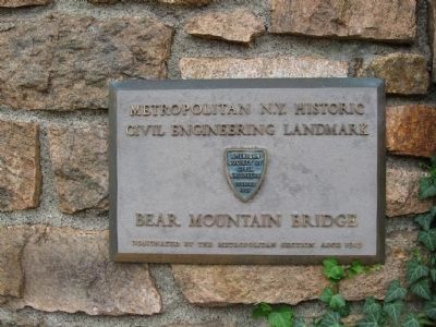
Bear Mountain Bridge
The first highway bridge to span the Hudson River south of Albany
Begun March 24th 1923 – Opened Nov. 27th 1924
To all who
With thought labor and loyalty have
Contributed to the construction of
This bridge and . . . — — Map (db m48083) HM
National Historic Civil Engineering Landmark
American Society of Civil Engineers 1852
Flight of Five Locks - New York State Barge Canal
The Greatest Series of High Lift Locks In The Shortest Distance Of Any Canal In The United . . . — — Map (db m58539) HM
National Historic
Civil Engineering Landmark
Waterford Bridges
Waterford, New York
The Union Bridge, the first to cross the lower Hudson River was built in 1804 at this site by Theodore Burr and lasted for 105 years until it was . . . — — Map (db m70365) HM
Erected 1854 - 1855 by
Nicholas Montgomery Powers
Famous bridge builder
Born Pittsford, Vermont, August 30, 1817
Died Clarendon, Vermont, 1897
This bridge, 232 feet in length, the
longest covered single-span wooden
bridge in the . . . — — Map (db m46983) HM
The first bridge of its type in the United States, the Linn Cove Viaduct is a product of design and construction techniques developed in Europe. The S-shaped structure contains 153 concrete segments, only one of which is straight. Weighing 50 tons . . . — — Map (db m134201) HM
Dismal Swamp Canal
c. 1805
Has Been Placed on The
National Register
of Historic Places
[Additional block to the right:]
National Historic
Civil Engineering Landmark
The Dismal Swamp Canal
Designated . . . — — Map (db m165189) HM
The original line of the Northern Pacific Railroad, now the Burlington Northern Santa Fe, descended into Valley City, crossed the Sheyenne River and continued out of the valley. Because of the steep grades, "pusher" engines were required to push . . . — — Map (db m242298) HM
This 1908 steel viaduct across the Sheyenne River Valley allowed the railroad to avoid steep grades. At 3886 feet (1184 meters) long and 155 feet (47 meters) high, it is an excellent example of this bridge type. — — Map (db m242299) HM
On December 15, 1967 at 4:58 pm, the 39-year-old silver bridge suddenly collapsed into the Ohio River during heavy rush hour and holiday season traffic. Forty-six lives were tragically lost. The cause of the collapse was a single hairline crack in a . . . — — Map (db m189706) HM
The Cincinnati Union Terminal opened in March 1933 and integrated rail travel in the city, which previously operated from five separate passenger terminals. Built when rail travel was already in decline, Union Terminal stopped operating as a . . . — — Map (db m23939) HM
The 1931 Anthony Wayne Bridge is truly an engineering wonder. Designed by Waddell & Hardesty, it was constructed for 2.6 million dollars by the McClintic-Marshall Company and was the first U.S. bridge to use deep, riveted plate girder spans. . . . — — Map (db m238157) HM
The Miami Conservancy District is a public
corporation established following the passage
of the Conservancy Act of Ohio in 1914. After
the 1913 flood inundated the Miami Valley,
local citizens were determined to avoid such
a disaster in the . . . — — Map (db m95581) HM
The Muskingum River Improvement, started in 1837, played a key role in economic development of the Greater Ohio River Valley as one of the nation's first complete slackwater navigation systems for steam-powered vessels, and survives as the most . . . — — Map (db m13382) HM
A colossus of engineering acumen and structural steel, the Airdock was built in 1929 as the construction facility for the U.S. Navy's rigid airships, the USS Akron (1931) and USS Macon (1933). The airships, or dirigibles, served as . . . — — Map (db m43475) HM
Patterson Bridge
(Rogue River Bridge)
Completed January 21, 1932 and dedicated In Memory to the Governor of Oregon Isaac Lee Patterson (1926-died in office 1929)
1932.... The bridge was considered the most advanced concrete . . . — — Map (db m113391) HM
Designed and built under the direction [of] Pennsylvania Railroad chief engineer and, later, company president, J. Edgar Thomson. Horseshoe Curve opened February 15, 1854. It was 366 meters across and 1310 meters long with a 1.8 percent grade. . . . — — Map (db m52488) HM
An integral part of the National Road, this was the first metal arch bridge in the United States, built 1836-39. Replacing several earlier bridges on this site, including an 1809 Finley suspension bridge, this 80-foot span was built of cast iron by . . . — — Map (db m251) HM
A tribute to the Armed Forces that have defended the United States of America.
————————————————————————
Following World War II, the National Council of State Garden Clubs designated certain national roads as "Blue Star Memorial Highway", as . . . — — Map (db m192552) HM WM
Designated a National Historic Civil Engineering Landmark in 1970, this tunnel is the oldest existing transportation tunnel in the United States. At the time of its construction it was considered a work almost unknown in this country.
Dug through . . . — — Map (db m84218) HM
“They have a Sett of Pumps which go by Water, which force the water up through leaden Pipes, from the River to the Top of the Hill, near an hundred feet.”
John Adams to Abigail Adams
1777
A bountiful spring supplied . . . — — Map (db m27191) HM
As the tallest and longest bridge of its time, the Kinzua Viaduct embodied the spirit of the industrial revolution. Cargo and sightseers rumbled across the viaduct for 120 years until an F1 tornado toppled the viaduct in 2003. Today, a skywalk and . . . — — Map (db m104941) HM
Originally begun in 1881 for the New York, Lake Erie & Western Railroad to ship coal, lumber, and oil, it was once the world’s highest and longest rail viaduct. Rebuilt in 1900 to carry heavier loads, it was in service until 1959. Kinzua Bridge . . . — — Map (db m51329) HM
The first commercial crossing of the Delaware River at Easton was a ferry enfranchised to David Martin in 1739.
Located near the present site of Scott Park at the junction of the Lehigh and Delaware Rivers, it operated until the beginning of . . . — — Map (db m114653) HM
The Fairmount Water Works ceased operations in 1909. Four new pumping stations with sand filtration beds began supplying Philadelphia with purified water.
In 1911 the Fairmount Park Aquarium opened in the Fairmount Water Works. One of the . . . — — Map (db m192676) HM
Planned
1682
Dedicated
1997
National Historic Civil Engineering Landmark The City Plan of Philadelphia Surveyor General Thomas Holme, Governor
William Penn & others Planned the open
Public Squares and Rational Street Layout . . . — — Map (db m230958) HM
Since its completion 30 years after construction began in 1871, City Hall has dominated the center city Philadelphia skyline. At Penn Square, the building is still the world’s tallest masonry load bearing structure, made of 88 million bricks and . . . — — Map (db m107585) HM
Here at Centre Square stood Philadelphia's first water works
The first public water system in America to use steam for large scale pumping — — Map (db m192791) HM
Built in 1847-48 by the Erie Railroad, it is the oldest stone railroad bridge in the State in use today. Viaduct is 1040 feet long, 100 feet high and 25 feet wide at the top. — — Map (db m52942) HM
Tunkhannock Viaduct
1912 — Built — 1915
by
The Delaware, Lackawanna and Western
Railroad Company
W. H. Truesdale — President
G. J. Ray — Chief Engineer
Flickwir & Bush — Contractors
Length 2375 feet • . . . — — Map (db m102847) HM
Hooten- Black House & Bamberg's National Historic District
The Hooten- Black House is the hub of art and history in Bamberg County where you will find changing art exhibitions,
concerts, and lectures on Bamburg County history. The Hooten- . . . — — Map (db m32840) HM
Built between 1807 and 1811, the east
wing was added after 1831. Residence
of William Aiken, first president (1828-1831)
of the South Carolina Canal and Rail Road
Company. This company inaugurated the
American steam railroad era at . . . — — Map (db m39838) HM
The combination of steep grades, sharp curves, creek crossings, and tunnels required exceptional civil engineering to satisfy the need for railroads required by the Black Hills mining boom.
Constructed 1881 to 1928 Designated by South . . . — — Map (db m183192) HM
The Tennessee State Capitol (constructed 1845 - 1877) was designed by
engineer and architect William Strickland. It was one of the first
buildings in the nation with structural iron roof trusses. The Capitol
grounds were designed by engineers . . . — — Map (db m163503) HM
Designed by William Strickland, noted Philadelphia architect who also designed the tower of Independence Hall. Construction was commenced in 1845 and completed 1859. Strickland died in 1854 and is entombed in the north portico. His son Francis, . . . — — Map (db m36112) HM
One in a network of ditches begun by the Spanish and their Indian charges at the founding of San Antonio in 1718. Hand-dug and made of dressed limestone, the acequia diverted water from San Antonio River through fields belonging to San Antonio de . . . — — Map (db m195103) HM
With the arrival of the railroads to El Paso in 1881, the train tracks marked the northern boundary of the city. As El Paso grew, the tracks divided downtown and created a time-consuming barrier for pedestrians and motorists. In the early 20th . . . — — Map (db m37855) HM
Following the hurricane of 1900, the greatest natural disaster of U.S. history, with the loss of 6,000 lives, civil engineers designed and built a concrete seawall and raised the elevation of Galveston Island, using pioneering materials and . . . — — Map (db m90439) HM
A designated Texas Historic Civil Engineering Landmark, the Corpus Christi Seawall has helped to protect the coastal city for more than seventy years. Periodically devastated by hurricanes, Corpus Christi began to consider a protective barrier in . . . — — Map (db m117454) HM
Historic Civil
Engineering Landmark
International Boundary Marker
Republic of Texas-United States
(Set April 23, 1841)
Designated by the Texas and Louisiana Sections — — Map (db m105272) HM
"The last rail is laid, the spike is driven. The Pacific Railroad is completed." Here at Promontory, Utah, at 12:47 P.M. on May 10, 1869, the driving of a Golden Spike completed the first Transcontinental Railroad. Climax of a dramatic . . . — — Map (db m133654) HM
This 5,613- foot-long tunnel, the longest vehicular tunnel in the National Park System, was blasted through the towering sandstone cliffs above Pine Creek Canyon. Construction required extraordinary access through cliff-face galleries for blasting . . . — — Map (db m74632) HM
National Historic Civil Engineering Landmark Great Falls Canal and Locks Constructed 1785-1802. Operated until 1821 ——— These works were the major feature of the first river navigation system for trade with the west. This pioneer waterway was . . . — — Map (db m4975) HM
The Crozet Blue Ridge Tunnel, 4,273 feet in length, was the longest railroad tunnel in North America when constructed in 1849-1858. Irish and enslaved craftsmen and laborers excavated the tunnel using hand drills and black powder. Chief Engineer . . . — — Map (db m170631) HM
Convinced of the need to more quickly and efficiently repair the nation's Navy ships, President John Quincy Adams and Congress agreed in 1827 to follow engineers' recommendations to build two dry docks, one here and one in Boston.
The . . . — — Map (db m76838) HM
The roundhouse is the sole surviving cast-iron framed roundhouse and is an important example of mid-19th century industrial building design. Designed by Albert Fink, in collaboration with Benjamin H. Latrobe, it represents an early use of . . . — — Map (db m1199) HM
National Civil Engineering Landmark. The re-construction of the Baltimore and Ohio Railroad Roundhouse and Shop Complex commenced soon after the end of the American Civil War in 1865. This complex included two roundhouses and two significant . . . — — Map (db m167682) HM
On December 15, 1967 at 4:58 pm, the 39-year-old Silver Bridge suddenly collapsed into the Ohio River during heavy rush hour and holiday season traffic. Forty-six lives were tragically lost. The cause of the collapse was a single hairline crack in a . . . — — Map (db m189713) HM
In 1816, with a strong interest in internal improvements, the legislatures of Virginia and Ohio authorized the formation of the Wheeling and Belmont Bridge Company (Belmont because the bridge company was to connect from Wheeling, Virginia to . . . — — Map (db m230968) HM
This property has been placed on the
National Register of Historic Places
Hoffman & Sons Co. Grocers
Designed by Ferry and Clas
Tour Site 18
1906 — — Map (db m75394) HM
On this site November 25, 1882 the Appleton Edison Light Co. began operating the first Edison Hydroelectric System in America.
Plaque donated to Outagamie County Historical Society by the family of Harold F. Parish November, 1979 — — Map (db m20865) HM
Constructed in just 8 months in 1942,
this 2,450 kilometre highway provided
an essential transportation link to the
northwest of North America during
the Second World War, and has since
remained a major . . . — — Map (db m135256) HM
English:
This is the longest span cantilever bridge in the world, stretching 548.6 meters between the main piers. Completed in 1917, it is a remarkable engineering achievement. To overcome technical problems that had caused the collapse of . . . — — Map (db m81248) HM
Reynando las Españas el Catolico Don Felipe V. que Dios guarde y siendo virrey de ésta Nueva España el Exmo. Marqués de Casa Fuerte, se empezó esta magnífica obra en la alberca el día 26 de diciembre de 1726 y se concluyó el día de octubre de 1735, . . . — — Map (db m100261) HM
International History
Civil Engineering Landmark
THE FORTH BRIDGE
Opened 4 March 1890
Engineers, Sir John Fowler & Sir Benjamin Baner
Main Contractor Tancred Arrol
Presented 27 August 1985 by
Institution of Civil Engineers . . . — — Map (db m85863) HM
Constructed:
Grangemouth to Glasgow - 1768-77
Glasgow to Bowling 1785-90
Closed: 1963 - - - Re-opened: 2001
Engineers: J. Smeaton, R. Mackell, R. Whitworth
This canal, which in addition to inland traffic, accommodated full-masted . . . — — Map (db m88039) HM
164 entries matched your criteria. Entries 101 through 164 are listed above. ⊲ Previous 100