73 entries match your criteria.
South Carolina Heritage Corridor Historical Markers
Designated by Congress in 1996 as a National Heritage Area, the Heritage Corridor runs from the foothills of Oconee County in the northwestern corner of the state, along the Savannah River, through the Edisto River Basin, to the port city of Charleston.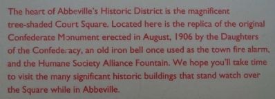
By Brian Scott, July 19, 2008
Abbeville Square Marker
| 1 ► South Carolina, Abbeville County, Abbeville — Abbeville Square — A Stately County Square — |
| On Court Square (State Highway 20), on the right when traveling south. | |||
| 2 ► South Carolina, Abbeville County, Abbeville — Parsons Mountain — Land Renewed — |
| On Campground Road. | |||
| 3 ► South Carolina, Abbeville County, Abbeville — Trinity Episcopal Church — Abbeville's Gothic Revival Church — |
| On North Church Street at Trinity Street, on the left when traveling north on North Church Street. | |||
| 4 ► South Carolina, Abbeville County, Calhoun Falls — Richard B. Russell Dam — Flood Control, Electric Power, and Recreation — |
| On Russell Dam Overlook Road (State Highway 1-269), on the right when traveling south. | |||
| 5 ► South Carolina, Abbeville County, Donalds — The Donalds Grange No. 497 — Patrons of Husbandry and Literacy — |
| On SC Highway 184, on the right when traveling north. | |||
| 6 ► South Carolina, Abbeville County, Due West — Abbeville County — Rich in History and Natural Resources — |
| On Depot Street, on the left when traveling north. | |||
| 7 ► South Carolina, Abbeville County, Due West — Erskine College — South Carolina's First Four-Year Church-Related College — |
| On Depot Street. | |||
| 8 ► South Carolina, Aiken County, Aiken — Aiken County Museum — |
| Near Newberry Street SW near 1st Avenue, on the right when traveling west. | |||
| 9 ► South Carolina, Aiken County, Wagener — Wagener Museum — |
| On Lee Street N. near Old Ninety Six / Indian Trail (South Carolina Highway 39), on the right when traveling west. | |||
| 10 ► South Carolina, Anderson County, Belton — Belton / Historic Belton — |
| On Holmes Street, on the left when traveling south. | |||
| 11 ► South Carolina, Anderson County, Honea Path — Honea Path — Pathways of a Southern Town — |
| On North Shirley Ave west of Chiquola Avenue, on the left when traveling east. | |||
| 12 ► South Carolina, Anderson County, Iva — Iva — A Small Railroad Town — |
| On East Front Street at East Broad Street, on the left when traveling south on East Front Street. | |||
| 13 ► South Carolina, Anderson County, Pendleton — Hunter's Store — An Upcountry General Store — |
| On East Queen Street, on the left when traveling east. | |||
| 14 ► South Carolina, Anderson County, Pendleton — Woodburn Historic House — |
| On Histori Lane. | |||
| 15 ► South Carolina, Anderson County, Williamston — Williamston — Saratoga of the South — |
| On Spring Street. | |||
| 16 ► South Carolina, Bamberg County, Bamberg — Bamberg — |
| On East Railroad Avenue near North Street, on the right when traveling west. | |||
| 17 ► South Carolina, Bamberg County, Denmark — Denmark Depot — |
| On West Baruch Street (U.S. 78) near South Cedar Avenue, on the left when traveling west. | |||
| 18 ► South Carolina, Bamberg County, Ehrhardt — Bamberg County — |
| On Rivers Bridge State Park Access Road, 0.2 miles east of State Highway S-5-8. | |||
| 19 ► South Carolina, Bamberg County, Ehrhardt — Conrad Ehrhardt Railroad Park — |
| On Low Country Hwy (State Highway 64) at Broxton Bridge Road / Broadway Street (U.S. 601), on the right when traveling west on Low Country Hwy. | |||
| 20 ► South Carolina, Bamberg County, Ehrhardt — Ehrhardt Hall — Bed and Breakfast — |
| On Broxton Bridge Road (U.S. 601) near College Street, on the left when traveling north. | |||
| 21 ► South Carolina, Bamberg County, Ehrhardt — Rivers Bridge State Historic Site — |
| On Rivers Bridge State Park near SC-S-5-8. | |||
| 22 ► South Carolina, Barnwell County, Blackville — Blackville — |
| On Main Street (State Highway 6-76) near Soloman Blatt Avenue (State Highway 3), in the median. | |||
| 23 ► South Carolina, Barnwell County, Healing Springs — Healing Springs — |
| On Spring Court (State Highway 6-358) near Healing Springs Road (State Highway 6-32), in the median. | |||
| 24 ► South Carolina, Colleton County, Jacksonboro — Pon Pon Chapel — Serving the Community for Many Years — |
| On Parkers Ferry Road. | |||
| 25 ► South Carolina, Dorchester County, Summerville — Linking Places and People — Then and Now — |
| On State Park Road, on the right. | |||
| 26 ► South Carolina, Edgefield County, Edgefield — Oakley Park Museum — Witness to Edgefield's Social and Political History — |
| On Columbia Road. | |||
| 27 ► South Carolina, Edgefield County, Edgefield — Welcome to Historic Edgefield — Home to Ten South Carolina Governors — |
| On Courthouse Square. | |||
| 28 ► South Carolina, Edgefield County, Trenton — Bettis Academy — 19th Century Education for African Americans — |
| On Nicholson Road. | |||
| 29 ► South Carolina, Edgefield County, Trenton — Horn's Creek Church — Early Edgefield County History — |
| On Old Stage Road, on the right when traveling south. | |||
| 30 ► South Carolina, Georgetown County, Georgetown — Hobcaw Barony — A Woman's Gift — |
| On Hobcaw Road. | |||
| 31 ► South Carolina, Georgetown County, Georgetown — Kaminski House Museum — a City's Legacy — |
| 32 ► South Carolina, Georgetown County, Georgetown — The Rice Museum — |
| Near Front Street at Screven Street, on the left when traveling north. | |||
| 33 ► South Carolina, Greenwood County, Greenwood — Emerald Farm — A Working Goat Farm — |
| On Emerald Farm Road. | |||
| 34 ► South Carolina, Greenwood County, Hodges — Park’s / Greenwood County — |
| On Cokesbury Road (State Highway 254), on the right when traveling south. | |||
| 35 ► South Carolina, Greenwood County, Ninety Six — Lake Greenwood — A Changing Landscape — |
| Near State Park Road. | |||
| 36 ► South Carolina, Greenwood County, Ninety Six — Ninety Six National Historic Site / Greenwood County — |
| On South Cambridge Street (State Highway 248) at County Route 225 on South Cambridge Street. | |||
| 37 ► South Carolina, Laurens County, Ware Shoals — Irvin Pitts Park / Ware Shoals — |
| On Power House Road, on the right when traveling east. | |||
| 38 ► South Carolina, McCormick County, Bordeaux — John De La Howe School — Still Caring...Still Dreaming — |
| Near Gettys Road (State Highway 81). | |||
| 39 ► South Carolina, McCormick County, Clarks Hill — Thurmond Dam and Lake / McCormick County — |
| On U.S. 221. | |||
| 40 ► South Carolina, McCormick County, McCormick — Dorn Mill — Production of Cotton Byproducts — |
| On North Main Street. | |||
| 41 ► South Carolina, McCormick County, McCormick — McCormick County / MACK — |
| On North Main Street. | |||
| 42 ► South Carolina, McCormick County, Mt. Carmel — Mt. Carmel Historical District — Village of Remembrance — |
| On Main Street (State Highway 81) at State Highway 95, on the right when traveling north on Main Street. | |||
| 43 ► South Carolina, McCormick County, Willington — Willington — A South Carolina Railroad Village — |
| On SC Highway 81, on the right when traveling north. | |||
| 44 ► South Carolina, Oconee County, Mountain Rest — Andrew Pickens Ranger District / Oconee County — |
| On Andrew Pickens Circle, on the right when traveling north. | |||
| 45 ► South Carolina, Oconee County, Mountain Rest — Walhalla State Fish Hatchery — The CCC and Resource Conservation — |
| On Fish Hatchery Road. | |||
| 46 ► South Carolina, Oconee County, Seneca — Andrew Pickens — Backcountry Revolutionary General and Legislator |
| On SC Highway 183. Reported missing. | |||
| 47 ► South Carolina, Oconee County, Seneca — Old Pickens Church — Sole Remnant of Town of Pickens |
| On SC Highway 183. Reported missing. | |||
| 48 ► South Carolina, Oconee County, Walhalla — Bethel Presbyterian Church — Founded by General Andrew Pickens — |
| On Bethel Church Road (State Road S37-198) just north of Lecroy Road (State Road S37-449), on the left when traveling north. | |||
| 49 ► South Carolina, Oconee County, Walhalla — Issaqueena Falls — Dramatic Cascades of the Upcountry — |
| On Stumphouse Tunnel Road. | |||
| 50 ► South Carolina, Oconee County, Walhalla — Oconee Heritage Center — Bringing History to Life — |
| On Browns Square Drive, in the median. | |||
| 51 ► South Carolina, Oconee County, Walhalla — Oconee Station / Oconee County — |
| On Oconee Station Road. | |||
| 52 ► South Carolina, Oconee County, Walhalla — Patriot's Hall: Oconee Veterans Museum — Lest We Forget — South Carolina National Heritage Corridor — |
| On Short Street east of South Church Street, on the left when traveling east. | |||
| 53 ► South Carolina, Oconee County, Walhalla — Stumphouse Mountain Tunnel — The Mountain that Defeated the Rail Line — |
| On Stumphouse Tunnel Road. | |||
| 54 ► South Carolina, Orangeburg County, Branchville — Branchville Depot — |
| On Freedom Blvd. (US 21) at Freedom Rd. (US 21), on the right when traveling north on Freedom Blvd. (US 21). | |||
| 55 ► South Carolina, Orangeburg County, Branchville — Orangeburg County — |
| On Freedom Boulevard (U.S. 21) near East Railroad Avenue, on the right. | |||
| 56 ► South Carolina, Orangeburg County, Holly Hill — Holly Hill — |
| On State Street (U.S. 176) at Depot Street, on the left when traveling east on State Street. | |||
| 57 ► South Carolina, Pickens County, Central — The Central History Museum — A Merchant Family's Story |
| On Church Street, on the right when traveling south. Reported unreadable. | |||
| 58 ► South Carolina, Pickens County, Central — The Central History Museum — A Southern Town's Past and Future |
| On Church Street. Reported unreadable. | |||
| 59 ► South Carolina, Pickens County, Clemson — Fort Hill — The Beginning of a Legacy — |
| On Fort Hill Street, on the left when traveling west. | |||
| 60 ► South Carolina, Pickens County, Clemson — Hanover House — Little by Little — |
| On Hanover Circle, in the median. | |||
| 61 ► South Carolina, Pickens County, Clemson — Hopewell Plantation — Home of General Andrew Pickens — |
| On Hopewell Road. | |||
| 62 ► South Carolina, Pickens County, Clemson — Hopewell Treaty Site — The Hatchet Shall be Buried — |
| Near West Cherry Road (State Highway S39-149). | |||
| 63 ► South Carolina, Pickens County, Clemson — The Old Stone Church — A Frontier House of Worship — |
| On Anderson Highway. | |||
| 64 ► South Carolina, Pickens County, Clemson — The Old Stone Church — The Cemetery — |
| On Anderson Highway. | |||
| 65 ► South Carolina, Pickens County, Easley — Golden Creek Mill — Water Power — |
| On Enon Church Road, 0 miles south of Dearborn Lane, on the left when traveling south. | |||
| 66 ► South Carolina, Pickens County, Pickens — Hagood Mill Historic Site — |
| On Hagood Mill Road, on the right when traveling east. | |||
| 67 ► South Carolina, Pickens County, Pickens — Pickens — The Town That Moved — |
| On Griffin Street. | |||
| 68 ► South Carolina, Pickens County, Pickens — The Hagood-Mauldin House — The Irma Morris Museum of Fine Art — |
| On North Lewis Street. | |||
| 69 ► South Carolina, Pickens County, Pickens — The Pickens County Museum — American Heroes and Everyday Folk — Living Music Traditions — |
| On Johnson Street. | |||
| 70 ► South Carolina, Saluda County, Ridge Spring — Ridge Spring — Small Town Living — |
| On West Main Street (State Highway 23) at State Highway 392, on the right when traveling east on West Main Street. | |||
| 71 ► South Carolina, Saluda County, Saluda — Flat Grove — The Bonham House — |
| On State Highway 329 at Boyd Branch Road, on the left when traveling north on State Highway 329. | |||
| 72 ► South Carolina, Saluda County, Saluda — Historic Saluda — A Town with Charm — |
| On Law Range at East Church Street (U.S. 378) on Law Range. | |||
| 73 ► South Carolina, Saluda County, Saluda — Saluda County Stockyard and Livestock Market — |
| On North Main Street (State Highway 121) at West Wheeler Circle, on the left when traveling north on North Main Street. | |||