On Main Street (Route 40) just east of Cape May Avenue (New Jersey Route 50), on the left when traveling east.
Dedicated as a lasting tribute to the men and women of Hamilton Township who served their country
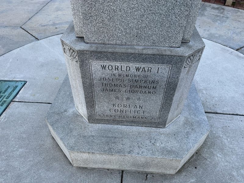
World War I
In memory of
Joseph Simpkins • Thomas Hannum • James Giordano
☆ ☆ ☆
Korean . . . — — Map (db m190884) WM
Near Atlantic City Expressway, 7.5 miles east of New Jersey Route 54, in the median.
(Quercus Alba) White Oak has a very distinctive light ashy gray bark. It occurs in a wide variety of habitats and grows very slowly. Trees 300 years old are not uncommon, and some have been known to live 600 years. It's uses are many, . . . — — Map (db m208366) HM
On Atlantic City Expressway, 7.6 miles east of 12th Street (New Jersey Route 54), in the median.
The original World Trade Center in March 2001. The tower on the left with antenna spire was 1 WTC. The tower on the right was 2 WTC. All seven buildings on the WTC complex are partially visible; refer . . . — — Map (db m153437) HM
On Atlantic City Expressway, 7.5 miles east of New Jersey Route 54, in the median.
Remember and honor the thousands of innocent men, women, and children murdered by terrorists in the horrific attacks of February 26, 1993 and September 11, 2001. Respect this World Trade Center Memorial made sacred through tragic loss. Recognize . . . — — Map (db m208365) WM
Near Batsto Road, on the left when traveling north.
In the 1840s, Batsto’s iron industry was failing due to competition from new iron industries using coal and iron ore (magnetite) rather than charcoal and bog ore (limonite). Looking for another industry to keep Batsto profitable, Jesse Richards . . . — — Map (db m76154) HM
Near Batsto Road, on the right when traveling north.
This series of belts and jackshafts were installed in the late 19th century. They were powered by the gristmill’s turbine, Their purpose was to turn grindstones for sharpening tools and to power the corn sheller housed in the adjacent corncrib. — — Map (db m76162) HM
On S. 3rd Street, on the right when traveling north.
Oldest church building originally located on the 600 block of Bellevue Avenue. Moved to it's present location in 1885. Original portion built in 1862. — — Map (db m188259) HM
Near Batsto Road, on the left when traveling north.
This boat is typical of the barges used to carry bog iron ore to the Batsto Furnace. It is estimated to be 150 years old and is 43 ft. long, with an 11 ft. beam. The boat was excavated from the north side of the Batsto Dam in 1957. — — Map (db m76159) HM
Near Batsto Road, on the left when traveling north.
While the Batsto Dam provided power to a once prospering village, it halted the natural migration of spawning fish. The Batsto River Fishway Project provides a pathway over the dam. This project improves the aquatic ecosystem and provides increased . . . — — Map (db m76157) HM
Near Batsto Road, on the left when traveling north.
Although the exact date and manufacturer of this wagon are not known, it is possible that it was made by the Auburn Wagon Works in Martinsburg, WV around 1900. Wagons were used to transport goods both on the farm and to local markets, boat landings . . . — — Map (db m76163) HM
On Pleasant Mills Road (County Route 643), on the right when traveling north.
All Wars Memorial in honor of Veterans of all Wars who served and gave their lives in an effort to protect our country and to preserve out freedom justice and democracy. Dedicated as the William K. Phillis War Memorial World War II Korean War . . . — — Map (db m76169) WM
Built by Charles Wiltsey in 1800. Later sold to David Albertso who ran the mill into the 1840's. Located on Great Swamp branch of the Egg Harbor River. — — Map (db m88457) HM
Near Atlantic City Expressway, 7.6 miles east of 12th Street (New Jersey Route 54), in the median.
Each flowering tree symbolizes a decade of achievement
Atlantic City Expressway
1964 - 2014
Construction of the Atlantic City Expressway began on August 1st, 1963. In one year's time it was opened to the traveling public at noon on . . . — — Map (db m153435) HM
Across this driveway stood the old Quaker (Friends) meeting house and school. At the monthly meeting of the Friends dated Jan. 1, 1731, it was concluded that “ye meeting for worship shall be removed from John Sculls (house) and shall . . . — — Map (db m92416) HM
The Leedsville Schoolhouse, also known as Linwood School #1, was built in 1873. The building is owned by the City
of Linwood and is occupied by the Linwood Historical Society. The building houses a local history museum and
archives. The surviving . . . — — Map (db m92425) HM
The Linwood Historic District has been placed on the National Register of Historic Places by the United States Department of the Interior.
The district reflects the architectural development of the community from village to city through the . . . — — Map (db m92414) HM
On Atlantic Avenue just west of South 24th Avenue, on the right when traveling west.
Great Egg
Coast Guard Station
has been listed in the
National Register
of Historic Places
by the United States
Department of the Interior
— — Map (db m153613) HM
On Atlantic Avenue just west of South 24th Avenue, on the right when traveling west.
On this day, Tropical Cyclone Sandy caused tidal flooding to rise to this level at this location! Tidal height was 8.8 ft. above Mean Lower Low Water
Be aware. Prepare. — — Map (db m153616) HM
On Ventnor Avenue at Oberon Avenue, on the left when traveling south on Ventnor Avenue.
August 30, 2003
Longport American Legion Post 469 Dedicates this Monument in honor of U.S. Armed Forces, past, present, and future, in recognition of sacrifices made for our Nation by Military Members and Families. We are eternally grateful. . . . — — Map (db m108866) WM
On Atlantic Avenue just west of South 24th Avenue, on the right when traveling west.
In grateful appreciation
to
Michael L. Cohen
Founder, Longport Historical Society
Author of "The Way We Were"
"Thanks for the Memories"
— — Map (db m153614) HM
On South 20th Avenue just south of Atlantic Avenue, on the right when traveling south.
Welcome to the labyrinth at the Church of the Redeemer. This labyrinth was truly a parish project: it was the inspiration of the Reverend Dabney J. Carr III, our longtime parish priest-in-charge; Milda Balsh, a church neighbor, donated the funds . . . — — Map (db m153617) HM
On Atlantic Avenue at S. Decatur Avenue, on the right when traveling north on Atlantic Avenue.
Welcome to Lucy the Elephant, one of our country's national historic landmarks and America's oldest roadside attraction.
This is the Carpenter Walkway, dedicated to Sylvia and Edwin Carpenter co-founders of the Save Lucy Committee. . . . — — Map (db m108865) HM
On Ventnor Avenue at S. Mansfield Avenue, on the right when traveling north on Ventnor Avenue.
In Memory Of
Lt. David Rogers
World War II
101st Airborne Division
In Memory Of
Mortimer Lewis, 3rd
World War II
Margate American Legion
Post 397
In Memory Of
Francis P. Boyle
World War II
Margate American Legion
Post 397 . . . — — Map (db m108797) WM
On Ventnor Avenue at S. Mansfield Avenue, on the right when traveling north on Ventnor Avenue.
Honor Roll
Erected As An Everlasting Tribute By
The Citizens Of Margate City
To Those Who Answered Their
Country’s Call
Theodore J. Haring★ Killed in Action · Harry McClain Wounded · Ollie Hackney · Leon . . . — — Map (db m108794) WM
On Ventnor Avenue near S. Mansfield Avenue, on the right when traveling north.
In Memory Of
Our Beloved Son
Lt. Arthur D. Wilson, Jr.
Pilot A.A.F.
And His Boyhood Friends And
Comrades In Arms Of This City
Who Made The Supreme Sacrifice
In World War II
Howard T. Shepherd · Francis P. Boyle · Francis X. Crowe · . . . — — Map (db m108795) WM
On Ventnor Avenue at South Mansfield Avenue, on the right when traveling east on Ventnor Avenue.
Dedicated to all those who
have served and to the many
who gave the Ultimate Sacrifice
to preserve freedom
Viet Nam
1957 - 1975
— — Map (db m153611) WM
On New York Road (U.S. 9) at Chestnut Neck Road (County Route 575), on the right when traveling north on New York Road.
In honor of the men of the 3rd Battalion Gloucester County Militia Col. Richard Somers – Commanding Killed in Action Pvt. Forrest Bellangy (Killed at Trenton #2) Pvt. John Cain (Murdered while POW in Tuckerton) Lt. John Lucas (Killed in . . . — — Map (db m76164) HM
On New York Road (U.S. 9) at Chestnut Neck Road (County Route 575), on the right when traveling north on New York Road.
In honor of the Brave Patriots of the Revolutionary War who defended their liberties and their homes in a battle fought near this site October 6, 1778 ---------- Dedicated October 6, 1911 Lower Plaque: Erected by the State of New Jersey . . . — — Map (db m10811) HM
On New York Road (U.S. 9) at Chestnut Neck Road (County Route 575), on the right when traveling north on New York Road.
This anchor, believed to be from a British Merchant ship captured by Privateers and sunk during the Battle of Chestnut Neck, October 6, 1778 Has been donated to the Col. Richard Somers Chapter, New Jersey Society, Sons of the American Revolution by . . . — — Map (db m76165) HM
Near Upper Pomona Road, 0.2 miles west of English Creek-Port Republic Road (County Road 575).
This stone marks the
site of the
Clark's Mill Meeting House
the first Presbyterian church
in Atlantic County
built 1761
used until 1820 — — Map (db m40603) HM
On Upper Pomona Road, 0.2 miles west of English Creek-Port Republic Road (County Road 575), on the right when traveling west.
Clark's Mills Meeting House, built by Thomas Clark about 1762, where preached the Rev. John Brainerd, stood on site of Clark Burying Ground. Thomas Clark, builder of the church, Thomas, Adrial, and Parker Clark, Revolutionary soldiers, are buried . . . — — Map (db m40582) HM
On New York Road (U.S. 9) at Chestnut Neck Road (County Route 575), on the right when traveling north on New York Road.
In honor of the “Privateers” who sailed and fought for American Independence “1776 – 1783” “Captains” “Ships” Samuel Allen John Badcock Rainbow John . . . — — Map (db m40339) HM
Near Park Avenue near Main Street (Route 575), on the right when traveling south.
Built by Micajah Smith about 1800. Named "Methodist Union Chapel at Blackman's Mills" when incorporated in 1837. Micajah Smith, John Van Sant, privateer captains, and Jonas Morse and James Bell, Revolutionary soldiers, are buried in the Church Yard. — — Map (db m40587) HM
On New York Road (U.S. 9) at Chestnut Neck Road (County Route 575), on the right when traveling north on New York Road.
The first settlement in what is now known as Atlantic County was made at Chestnut Neck, on the west bank of the Mullica River, near where the village of Port Republic is now located. In 1637, John Mullica sailed up the river that took his name, . . . — — Map (db m76179) HM
Bass Harbor was a busy port for barges and sloops which carried produce, wood and ice to local businesses and residences. From privateering and smuggling, to clamming and fishing, to recreational boating, the bayfront has always played an active . . . — — Map (db m64277) HM
Gateway Casino, Tony Mart’s Bay Shores, Steel’s Ship Bar were all located at this end of Bay Avenue. They made up the musical heart of the bay-front, from the big bands and marathon dances of the 30’s and 40’s to the rock and roll greats of the 50’s . . . — — Map (db m64290) HM
On W. New York Avenue at 1st Street on W. New York Avenue.
And his immediate family, Grandson of John Somers, First settler, 1693, member of 3rd Regiment, Gloucester County militia. Monument erected 1850 in memory of his son, Master Commandant Richard Somers, U.S.N. 1778-1804. Site restored 1981. — — Map (db m92407) HM WM
Due to its location on the water, this area has historically been a transportation hub. In 1717, John Somers, Supervisor of Roads for Cape May County, began work on the Nacote Trail. Now known as Shore Road, it connects Somers Point with Port . . . — — Map (db m64291) HM
Due to the deepwater harbor and the availability of timber, shipbuilding thrived along the Great Egg Harbor Bay from 1860-1890. Three-masted schooners, the likes of the Emma Cottingham and the 21 Friends, as well as sloops and barges dotted the . . . — — Map (db m64278) HM
Somers Mansion, thought to be the oldest house in Atlantic County, was built in the early 1720’s. The first record of the house is in the Meeting minutes of the Great Egg Harbor/Cape May Society of Friends in 1726 when the group met at the home . . . — — Map (db m64293) HM
On Shore Road at W. New Jersey Avenue, on the right when traveling south on Shore Road.
Somers Point Bapist Church
1886
Shore Road Historic District
Has Been Recognized
As Historically Significant
By The
City of Somers Point, New Jersey — — Map (db m108914) HM
On Shore Road at W. New Jersey Avenue, on the right when traveling south on Shore Road.
Somers Point City Hall
1906
Shore Road Historic District
Has Been Recognized
As Historically Significant
By The
City Of Somers Point, New Jersey — — Map (db m108948) HM
On Shore Road at W. New Jersey Avenue, on the right when traveling south on Shore Road.
In
Honor Of
Those Who
Served Their
Country
In The
World War
Roy Black · Chris Spitz · Raymond Fox · Madison Fox · Fred H. Manley · Forrest Conove · Oscar Doughty · Harrison Cramer · Albert Cramer · Charles H. Collins · William H. . . . — — Map (db m108945) WM
On Shore Road at W. New Jersey Avenue, on the right when traveling south on Shore Road.
To Our Hero Dead in World War II
1941 1945
The City of Somers Point
Pays Homage to The Memory
Of These Valiants Who Gave The Last
Full Measure of Devotion to Their Country
James N. Chenoweth · H. Pual Clark · Edmond L. Eliason, Jr. · . . . — — Map (db m108947) WM
United States Submarine Veterans-our creed "To perpetuate the memory of our shipmates who gave their lives in the pursuit of their duties while serving their country. That their dedication deeds and supreme sacrifice be a constant source of . . . — — Map (db m92408) WM
Dating from the late 1800’s, this empire-style building was one of the many tavern-hotels in the historic district. Tourists came for fishing parties, sea bathing, hearty food, healthful sea air, and a bay view from the veranda. — — Map (db m64280) HM
Shore Road, completed in 1731, was the main artery for transportation and trade connecting Nacote Creek (Port Republic) to Somerset Plantation (Somers Point) and to Cape May County by Job’s Ferry. In 1880, connecting Philadelphia to Ocean City, . . . — — Map (db m64289) HM
Born at this site on September 15, 1778, educated in Philadelphia, Somers led the Battle of Tripoli and sacrificed his life on September 4, 1804. He is memorialized by both a monument at the U.S. Naval Academy and a U.S. Navy ship commissioned in . . . — — Map (db m92406) HM
On Stainton Memorial Causeway (New Jersey Route 52) 0.1 miles south of Mays Landing Road, on the right when traveling south.
Transportation and the Development of Tourism in Ocean City
Ocean City was founded in 1879 as a permanent community and seaside Christian resort where residents and summer visitors could enjoy physical and spiritual rejuvenation at the . . . — — Map (db m153625) HM
On Stainton Memorial Causeway (New Jersey Route 52) 0.1 miles south of Mays Landing Road, on the right when traveling south.
World War Memorial Bridge Design
The World War Memorial Bridge over Ship Channel was a 47-span vehicular bridge designed to carry two lanes of traffic in each direction. The bridge measured 1,442 feet long and 40.3 feet wide. As shown in . . . — — Map (db m153628) HM
On Boardwalk at South Marion Avenue, on the right when traveling east on Boardwalk.
The name Ventnor was given to this area by the Camden and Atlantic Land Company in 1889. The name was derived from a health resort the Isle of Wright in the English Channel.
In 1891, the Carisbrooke Inn was built on Harvard Avenue. This . . . — — Map (db m153593) HM
On South Somerset Avenue just north of Boardwalk, on the right when traveling north.
A Grammy sat here one day with her grandson in hand. It was June 2006 when she imagined a new "fabulous" state of the art play environment…to set a precedensce by building the first handicap accessible playground from A.C. to Longport with music, . . . — — Map (db m153604) HM
On South Somerset Avenue just north of Boardwalk, on the right when traveling north.
Ventnor City Municipal Hall
The present city hall is part a memorial to the veterans of World War I, as dedicated on June 15, 1929, under the auspices of the James Harvey American Legion Post #144. This Tudor-style building, designed by . . . — — Map (db m153603) HM
On S. New Haven Ave. south of Atlantic Ave., on the left when traveling south.
This is the Keystone that was over the main entrance of the Oxford Avenue School. This was Ventnors first school building, built in 1909 and torn down in 1986. Second smaller keystone was over another entry. — — Map (db m190482) HM
On Boardwalk at South Oakland Avenue, on the right when traveling east on Boardwalk.
Time has taken its toll on the disappearing act of full "bathing costumes." Back in the early 1900s, women wore black, knee-length, puffy sleeved wool dresses. But times began to change and soon women began wearing less and less. In 1945, Louis . . . — — Map (db m153596) HM
On Boardwalk at South Sacramento Avenue, on the right when traveling east on Boardwalk.
Erection of the first boardwalk began in 1905 and was completed in 1910. The Ventnor Fishing Pier was completed in the late 1920s and was originally free admission. Soon after overcrowding forced authorities to make admission by membership card . . . — — Map (db m153607) HM
On Boardwalk at South Portland Avenue, on the right when traveling east on Boardwalk.
Ventnor City Hall was built by engineer Vivian B. Smith in 1929, who designed the building to harmonize with the surrounding residences. The structure served the dual purpose of a municipal office building, assembly hall and headquarters for the . . . — — Map (db m153606) HM
On Boardwalk at South Somerset Avenue, on the right when traveling east on Boardwalk.
The Ventnor City Police department has been committed to maintaining the safety of its citizens and visitors to this seashore community for almost 100 years. In this time, the police department has come a long way from its ranks of a half dozen . . . — — Map (db m153605) HM
On Atlantic Avenue at S. Cambridge Avenue, on the left when traveling north on Atlantic Avenue.
Veterans Memorial
In Honor And Memory Of All
Men And Women Of All Wars And Those
Who Made The Supreme Sacrifice
WWI WWII Korea Vietnam Persian Gulf
( bronze plaque )
A Tribute By The Citizens Of Ventnor City
To Forever . . . — — Map (db m108725) WM
On Atlantic Avenue at S. Cambridge Avenue, on the left when traveling north on Atlantic Avenue.
Erected
In Honor Of
The Boys From
Ventnor City
Who Served In
The World War
This Memorial
Was Made Possible
Through The Efforts
Of Navajo Tribe
No. 275 I.O.R.M.
And Citizens Of
This City
Committee
James C. Scull · . . . — — Map (db m108721) WM
On South Somerset Avenue just north of Boardwalk, on the right when traveling north.
Former Ventnor City Lifeguard and Rowing Champion Dr. John W. Holland started the Viking Rowing Club in 1959. A few years later sculling and sweeping (crew) were introduced as the new sport. The Club, located in Ventnor Heights, operates programs . . . — — Map (db m153601) HM
On Weymouth Road, 0.3 miles east of Black Horse Pike.
Canoe trips: Canoeists can enjoy 12 miles of natural pine barrens environment along the Great Egg Harbor River from Penny Pot in Folsom through Weymouth Park to Lake Lenape in Mays Landing. Trip length varies from 2 hours to all day, depending on . . . — — Map (db m64263) HM
Welcome to Atlantic County’s Park at Weymouth Furnace which was developed around the remains of an early 1800’s iron furnace. These remains are an important link to Atlantic County’s rich history. This furnace turned out iron pipe and utilitarian . . . — — Map (db m64264) HM
On Weymouth Road, 0.3 miles east of Black Horse Pike.
Early 19th Century South Jersey iron furnace. Iron was produced from “Bog Ore” mined in surrounding swamps and brought to furnace by small barges poled along canals. Iron Castings, Stoves, Pots and Pans were made. Weymouth cast cannon . . . — — Map (db m64262) HM
On Park Avenue at Brookside Avenue, on the right when traveling south on Park Avenue.
Dedicated to the memory of our boys who made the Supreme Sacrifice in World War II 1941 – 1945 David L. Ceely John J. Fox Edward J. Hamilton Eugene A. Ivers Bruce S. Macintyre John A. Sawyer Harold W. Scott, Jr. Charles A. Yeomans Dedicated . . . — — Map (db m43939) HM
On W. Allendale Avenue at Delta Court, on the right when traveling east on W. Allendale Avenue.
John H. Van Houten came to this neighborhood in 1792 and later purchased land. His son, Paul J. Van Houten, built this farmhouse about 1869 on family acreage. In 1870 he willed it to his daughter, Margaret Ann, the wife of John L. Yeomans, a . . . — — Map (db m43788) HM
On Palisades Interstate Parkway, on the right when traveling north.
At Lower Closter Dock – on the riverfront just south of here – a British invasion force of 5,000 troops commanded by Lord Cornwallis landed before dawn on November 20, 1776. Guided by three Bergen County residents, they climbed the . . . — — Map (db m144530) HM
The background photograph shows Alpine Landing – here – known earlier as Closter Landing or the Closter Dock – around 1897. From before the Revolutionary War, a steep road through a break in the cliffs of the Palisades allowed . . . — — Map (db m47509) HM
On Old Dock Road at Old Dock Road on Old Dock Road.
Made of local blue stone, dedicated on August 17, 1871. Resting at the summit of the Palisades on the historic Closter Dock Road and Old Dock Road. Designed by renowned Architect J. Cleveland Cady.
Fisherman, quarrymen, laborers and local . . . — — Map (db m207905) HM
On Closter Dock Road (County Route 502) at Old Dock Road, on the right when traveling west on Closter Dock Road.
Laid out in 1761 by New York over an earlier route when that province claimed jurisdiction over this area. Used by troops during the Revolutionary War, the road led from Closter to Closter Dock on the Hudson where farm produce was shipped to New . . . — — Map (db m7208) HM
Near Alpine Approach Road, on the left when traveling north.
Cornwallis Headquarters Nov. 18th 1776 Restored with the assistance of the New Jersey State Federation of Women’s Clubs by the Palisades Interstate Park Commission • 1933 • — — Map (db m116946) HM
Near Henry Hudson Drive, on the left when traveling south.
Lower Closter or New DockHere a British invasion force of 5,000 troops commanded by Lord Cornwallis landed before dawn on November 20, 1776. Guided by three Bergen County residents, Joseph Hawkins, Isaac Perkins, and John Aldington, they climbed . . . — — Map (db m142465) HM
On 20 November 1776 British general Charles Cornwallis led 5,000 men across the Hudson and up a primitive farm road in the Palisades to begin the march south to capture the American fortifications at Fort Lee (A on the map, lower right). Word . . . — — Map (db m47508) HM
On Cedar Street, on the left when traveling north.
Francis Jackson, a freed slave, purchased 7 ¾ acres of woodland here in 1868. Later it would include the black cemetery and “a plain neat little church” built about 1873. The Pastor, Rev. Nicholas Fr. Jackson, lived nearby. The cemetery had 72 . . . — — Map (db m7509) HM
On West Church Street, on the right when traveling west.
Organized in 1723 as the Schraalenburg Dutch Reformed Church. First church erected in 1728, 150 feet to the east, the present building in 1799. The True Reformed Church was founded here in 1822. The church became Presbyterian in 1913. John Henry . . . — — Map (db m7506) HM
On West Fort Lee Road at River Road, on the left when traveling west on West Fort Lee Road.
In 1642, when this area was part of New Netherland, Johannes Winckelman built near here a ninety-foot long fur trading post and farmhouse – a building which sheltered both settlers and cattle. During the 1643 Indian war it was protected by five . . . — — Map (db m7128) HM
On Palisade Ave. at Franklin Ave., on the right when traveling north on Palisade Ave..
Dedicated to the memory of Palisades Amusement Park "Here we were happy. Here we grew!" "This is dedicated to the men and women who worked and played at Palisades Amusement Park, especially to the man who was its Spirit, its Shaker and its . . . — — Map (db m43656) HM
On Durie Avenue at High Street, on the right when traveling south on Durie Avenue.
In 1899 the schoolhouse property was bought from the Bloomer family. The following year a two story, square plan, Renaissance Revival style building was completed with 3 classrooms and an assembly room for grades K-8. In 1907, 4 classrooms were . . . — — Map (db m7912) HM
On Piermont Road (Route 501), on the right when traveling north.
Built about 1786 by Daniel De Clark, the frame kitchen wing was added in the early 1800’s. De Clark operated a large cattle and dairy farm on 170 acres of land. In 1815 son William was the owner and he sold the house to his grandson, Jacob D.C. . . . — — Map (db m7916) HM
On Durie Avenue at Legion Place, on the right when traveling west on Durie Avenue.
To ease post-WWII housing shortages, the Lustron Corp. of Ohio made an unique house of all pre-fabricated steel parts on an assembly line basis and shipped them directly to owners lots. Harold Hess purchased a Westchester Deluxe model with attached . . . — — Map (db m174139) HM
Built in 1871 for Hilderbrant Naugle on a suburban lot near the Closter R.R. depot, the frame gable-front-and wing house is notable for the ornamental scroll work of Gothic design. Naugle was a carpenter and clockmaker who made improvements to his . . . — — Map (db m7919) HM
4566 entries matched your criteria. Entries 201 through 300 are listed above. ⊲ Previous 100 — Next 100 ⊳