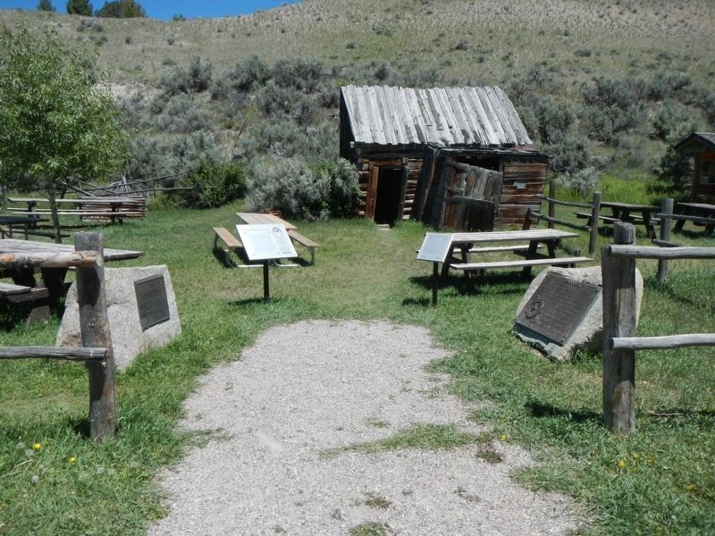
On Bannack Road near State Highway 278, on the left when traveling east.
Sidney Edgerton arrived at Bannack from Ohio in September 1863 to begin his appointment as Chief Justice of the Supreme Court of Idaho Territory. The massive territory encompassed Idaho, all of Montana, and the western half of Wyoming, with the . . . — — Map (db m124263) HM
Lewis and Clark Trail 1806
First important gold camp 1862
Scene of vigilante activities 1863
First capital Territory of Montana 1864-1865
First county seat of Beaverhead County 1864-1881
In grateful memory of the early pioneers who . . . — — Map (db m49535) HM
On Interstate 15 at milepost 55 near Rebich Lane, on the right when traveling south.
Montana's first gold rush began near here at Grasshopper Creek in the summer of 1862. Prospectors John White and company camped along the insect infested banks as they looked for a shortcut to the Deer Lodge valley. They panned the gravel - as was . . . — — Map (db m124290) HM
On MT 278 West, on the right when traveling north.
Lewis and Clark Trail 1806. First Important Gold Camp 1862. Scene of Vigilante Activities 1863. First Capital Territory of Montana 1864-1865. First County Seat of Beaverhead County 1864-1881. In grateful memory of the early pioneers who founded our . . . — — Map (db m145711) HM
Near Bannack Road (State Highway 278), on the left when traveling east.
Bannack epitomizes the tough, primitive towns that sprang up with gold discoveries. Its story also illustrates a century of survival, through boom and bust periods associated with resource extraction and technological advances. On July 28, 1862, . . . — — Map (db m124262) HM
On E. Glendale Street at South Washington Street, on the right when traveling north on E. Glendale Street.
This tablet marks the site of the first public school building which was also used for the first court house-theatre and library in Dillon
Dedicated to the pioneers of the valley on the fiftieth anniversary of the founding of Dillon.
Placed by . . . — — Map (db m145700) HM
On South Pacific Street at East Clark Street, on the right when traveling west on South Pacific Street.
The Martin Barrett House, built in 1912, was the in-town retirement home of prominent pioneer rancher, politician and philanthropist Martin Barrett and his wife Alice. One of the finest examples of early-twentieth-century architecture in Dillon, the . . . — — Map (db m209432) HM
On State Highway 278 near Bull Creek Road, on the right when traveling south.
For generations the Hamilton Ranch was widely-known as the Carroll Ranch - and it served as a vital link between the Big Hole and Beaverhead valleys. Its location at the base of this mountain pass made the ranch a perfect stopping point for . . . — — Map (db m124225) HM
On North Crawford Avenue near West 6th Street, on the left when traveling north.
In 1900, John Svaren left his home in Bergen, Norway, to join family in South Dakota. There he learned English before homesteading to North Dakota in 1909. With his bride, Betsy, Svaren arrived in Hardin in 1917 to build a home. He applied his . . . — — Map (db m189331) HM
On U.S. 287 near Springville Lane, on the right when traveling north.
Shortly after the discovery of gold in Confederate Gulch, freighters established a road between Helena and Diamond City. The Missouri River was a barrier to travelers until John Oakes established a ferry in Black Rock Canyon in 1865. A small . . . — — Map (db m141733) HM
On State Highway 287 near Springville Lane, on the right when traveling north.
In 1864, prospectors discovered promising placer gold deposits in Confederate Gulch, named for their political sympathies during the Civil War. This led to a huge gold rush that brought thousands of people to the gulch and the discovery of some of . . . — — Map (db m141735) HM
On Main Street near U.S. 12, on the right when traveling west.
(Three historical panels are located at this informational kiosk:)(Panel 1:)
Winston - A Town with Dreams of Striking it Rich
Winston History
Welcome to the community of Winston and this area of the . . . — — Map (db m188668) HM
On West Main Street near North 2nd Street, on the right when traveling west.
Platted in 1905 by George Lamport and Robert Leavens, Bearcreek was the center of an extensive underground coal mining district. At its height during World War I, Bearcreek boasted a population of nearly 2,000 people. The community was ethnically . . . — — Map (db m190160) HM
On State Highway 308, 0.1 miles west of Scotch Coulee Road, on the right when traveling west.
Thirty-nine corrugated metal structures mark the site of the Smith Mine, a ghostly reminder of a once vibrant mining district. The Montana Coal and Iron Company (MCI) began developing the Smith Mine in earnest after the arrival of the Montana, . . . — — Map (db m190143) HM
On Railroad Street (State Highway 72) near Broadway Avenue, on the left when traveling south.
Shortly after this area was removed from the Crow Reservation in 1892, homesteaders settled along the fertile Clarks Fork River to raise wheat. The discovery of rich coal deposits along Bear Creek, seven miles to the west, generated interest among . . . — — Map (db m167143) HM
Jim Bridger arrived in Montana in 1822 as a member of a Rocky Mountain Fur Co. brigade. For years he had no more permanent home than a poker chip. He roamed the entire Rocky Mountain region and often came through this part of the country. A keen . . . — — Map (db m96630) HM
On South Main Street near Jim Bridger Road, on the left when traveling south.
Jim Bridger arrived in Montana in 1822 as a member of a Rocky Mountain Fur Co. brigade. He roamed the entire Rocky Mountain region and often came through this part of the country. A keen observer, a natural geographer and with years of experience . . . — — Map (db m167010) HM
On U.S. 310 near Sand Creek Road, on the left when traveling south.
The Pryor Mountains to the east cover roughly 300,000 acres. Once entirely Crow Indian territory, now only the north end of the range is on the Crow Reservation. The south end is in the Custer National Forest. The range is bound on the east by . . . — — Map (db m166982) HM
On West River Street near Montana Avenue, on the right when traveling west.
Jewish merchant Samuel Greenblatt moved to Fromberg from Gebo in 1900. An immigrant from Russia, Greenblatt built the town’s first commercial building. Two years later he married Jennie Hetch of Chicago at Temple Emanu-El in Helena. Greenblatt built . . . — — Map (db m166929) HM
On North Broadway Avenue (U.S. 212) south of 11th Street, on the right when traveling south.
This two-story building was under construction in 1907, and for a short time housed part-owner Charles Antilla’s dry goods store. In 1912, new owners Ed Ricketts and C. V. Lucas located their Okay Meat Market, later the Red Lodge Meat Market, on the . . . — — Map (db m45388) HM
On North Broadway Avenue (U.S. 212) north of 10th Street, on the left when traveling north.
Photographer Mark E. Hawkes and his son Charley built a photography studio at this location where much of Red Lodge’s history was documented in pictures. Charley later struck out for Great Falls, and son Harry joined Mark. Hawkes & Son sold the . . . — — Map (db m45405) HM
On U.S. 212 near Two Mile Bridge Road, on the left when traveling north.
Finnish immigrant Ephraim Kent settled in Red Lodge in the early 1900s to work in the coal mines while his wife, Fiina, began a small dairy business. It was a family venture from the start, with all the children pitching in to deliver raw milk in . . . — — Map (db m190567) HM
On Broadway Avenue North near 3rd Street East, on the left when traveling north.
This log cabin was the home of one of Montana's most notorious citizens - John "Liver-Eating" Johnston, a sobriquet he earned in 1869 while cutting wood for the Missouri River steamboats in north central Montana. After a battle with the Lakota, he . . . — — Map (db m190093) HM
On South Broadway Avenue (U.S. 212) at South Hauser Avenue, on the right when traveling east on South Broadway Avenue.
Coal was discovered in the Rock Creek Valley nearly two decades before Red Lodge was established as a mail stop on the Meeteese Trail in 1884. In 1887, the Rocky Fork Coal Company opened the first large-scale mine at Red Lodge sparking the . . . — — Map (db m45250) HM
On 12th Street at North Broadway Avenue (U.S. 212), on the right when traveling west on 12th Street.
Rapid growth of the young town of Red Lodge coincided with the arrival of the Northern Pacific Railroad’s branch line in 1889. The area became Montana’s leading coal mining region. Town lots were platted by the secretary of the Rocky Fork Town and . . . — — Map (db m45386) HM
On South Broadway Avenue (U.S. 212) at South Hauser Avenue, on the right when traveling east on South Broadway Avenue.
According to tradition, a band of Crow Indians left the main tribe and moved west into the foothills of the Beartooth Range many years ago. They painted their council tepee with red-clay and this old-time artistry resulted in the name Red Lodge. . . . — — Map (db m45247) HM
On State Highway 7 near Heggen Road, on the right when traveling north.
Some people claim an old buffalo hunter figured that starting a thirst emporium for parched cowpunchers on this end of the range would furnish him a more lucrative and interesting vocation than downing buffalo. He picks a location and was hauling a . . . — — Map (db m164322) HM
On Castner Street (State Road 331) at Bridge Street, on the right when traveling north on Castner Street.
The town of Belt owes its existence to the coal mines located here in the 1890's. In those days the pop. was 4,000. The Anaconda mine, seen here, employed 1,000 men and produced 2,500 tons of coal daily.
The bituminous coal went to the Anaconda . . . — — Map (db m143651) HM
On Castner Street (State Road 331) near Bridge Street, on the right when traveling north.
Pennsylvania native John Castner discovered rich coal deposits along Belt Creek in 1870. Within just a few years, he and Fort Benton trader T.C. Power opened a commercial coal mine near here. The partners sold coal for use by the Great Northern . . . — — Map (db m143650) HM
On Castner Street (State Road 331) near 5th Street, on the right when traveling north.
Lewis and Clark named nearby Belt Butte for its girdle of rocks and, in 1877, John Castner named his town Belt. Coal brought Castner here, and Fort Benton was the first market for his Castner Coal Company. Then, in 1889, the Boston and Montana . . . — — Map (db m143649) HM
On State Highway 200, 0.2 miles west of Dr Russell Road, on the right when traveling west.
Barring fur trading posts, the first important white settlements in Montana were the mining camps in the western mountains.
Everything to the east belonged to the plains Indians and was buffalo range.
To protect the miners and settlers from . . . — — Map (db m101871) HM
On 4th Avenue North near 4th Street North, on the right when traveling west.
Great Falls’ premier residential street, Fourth Avenue North, gained 24 new homes between 1900 and 1910. Among them was this substantial residence, constructed in 1904 for bookkeeper Edgar Newlon and his wife Anna. The home is a classic American . . . — — Map (db m143823) HM
On 3rd Avenue North at 3rd Street North, on the left when traveling west on 3rd Avenue North.
The Boston and Montana Consolidated Copper and Silver Mining Company, later acquired by the Anaconda Company, chose a treeless bluff overlooking the river to locate its smelter and refinery in 1892. Among the seventeen managers’ houses built at . . . — — Map (db m143828) HM
The pioneer Methodist circuit rider William Wesley Van Orsdel—better known as “Brother Van”—arrived in Fort Benton, Montana, on the steamboat, Far West, in 1872. For forty-five years, he traveled on horseback, by wagon, by rail, and, finally, as a . . . — — Map (db m143788) HM
On 4th Avenue North near Park Drive North, on the right when traveling west.
Great Falls founder Paris Gibson was drawn to the power of the falls of the Missouri where he vowed to found an industrial center of “unsurpassed beauty.” Backed by railroad magnate James J. Hill, Gibson hired H. P. Rolfe to plat the . . . — — Map (db m143857) HM
On 2nd Avenue Northwest at 10th Street Northwest, on the right when traveling west on 2nd Avenue Northwest.
Irish-born Timothy Collins followed the gold stampedes to Montana but soon turned to law and politics. For a time in the 1870s he was the only attorney practicing in Meagher County. Elected to the territorial legislature several times, Collins was a . . . — — Map (db m143677) HM
On 4th Avenue North at 3rd Street North, on the left when traveling west on 4th Avenue North.
Apartment buildings were good investments in rapidly expanding communities like Great Falls, which grew from 17,000 to 26,000 between 1910 and 1920. Owners reported waiting lists for units, which ranged from rooms in old-fashioned “apartment . . . — — Map (db m143824) HM
Near Overlook Drive south of 10th Avenue South (Business Interstate 15), on the right when traveling west.
For Meriwether Lewis in 1805, the falls were an obstacle on the journey to the Pacific. To Paris Gibson (near right) the falls were a source of great opportunity. As Gibson laid out the townsite of Great Falls he envisioned dams to harness the falls . . . — — Map (db m126545) HM
On Main Street (U.S. 89) at East Granite Street, on the right when traveling south on Main Street.
Rich veins of silver were mined in the Historic Neihart Mining District for a fifty-year period beginning in July 1881. Remnants of the first claim, the Queen of the Hills mine, are located just a few hundred yards north of where you are standing. . . . — — Map (db m128300) HM
On State Highway 200 at Choteau Street, on the right when traveling west on State Highway 200.
When John Mullan built a wagon road across western Montana in 1860, he utilized a ford across the Sun River just a few yards west of here that had been used by the Indians for generations.
In 1862, the crossing was the site of a government . . . — — Map (db m101870) HM
Born in Wales, Robert Vaughn farmed and mined coal in the Midwest before leaving Illinois in 1864 for the Montana goldfields. Observing how his ponies and oxen “fattened readily on weathered bunch grass,” even in winter, he filed for a . . . — — Map (db m143905) HM
On Broadway (U.S. 87) at McNamara Avenue, on the left when traveling north on Broadway.
According to legend, the town and the creek got their name from the muleskinner "Big Sandy" Lane. The creek was flooded during one of his long treks from Cow Island to Fort Benton. When "Big Sandy" fluently bewailed his bad luck in superlatives . . . — — Map (db m142531) HM
Near Judith Landing Road (State Highway 236), on the left when traveling south.
You stand now in an area that was one of the first to feel the rapid growth of immigration that began about 60 years after Lewis and Clark camped here. Steamboats in the late 1800s chose this area as a key stopping point, because the trees needed . . . — — Map (db m161840) HM
On Front Street near 15th Street, on the right when traveling north.
"It's a tough town. Walk in the center of the street and keep your mouth shut," Gunslingers walked this street; few earned a reputation but more earned eternity here than in other fabled western towns.
Indians were fair game. Their corpses dumped . . . — — Map (db m142304) HM
On Front Street near 17th Street, on the right when traveling north.
Thomas Francis Meagher was born in Ireland in 1823. An Irish Revolutionary, he was caught and sentenced to death. Meagher's sentence was commuted to exile in Tasmania but he escaped to the United States. As a Brigadier General, Meagher commanded the . . . — — Map (db m142253) HM
On U.S. 87 near County Road 386, on the right when traveling north.
Founded in 1846 as a fur post, Fort Benton is the oldest continuously inhabited settlement in Montana. From its palisaded walls grew the most important transportation center in the Northwest. Trails led to all points of the compass, carrying goods . . . — — Map (db m141987) HM
On U.S. 87 near State Highway 233/80, on the right when traveling north.
Alexander Culbertson established Fort Benton in 1846 as an American Fur Company trading post. The remote settlement prospered in the 1850s, but it wasn't until the following decade that it really boomed. The arrival of the steamboat Chippewa at the . . . — — Map (db m142483) HM
On U.S. 87 near State Road 233&80, on the right when traveling north.
Fort Benton was the eastern terminus of the Mullan Military Road. Construction of the road began in the summer of 1859 at Fort Walla Walla, the head of navigation on the Columbia River. Lieutenant John Mullan of the U.S. Topographical Engineers . . . — — Map (db m142484) HM
On Front Street at 17th Street, on the right when traveling north on Front Street.
Originally a pretentious two-story frame hotel familiar to all rivermen, the Choteau House was built in the spring of 1868. T.C. Power and I.G. Baker constructed the building between their businesses to rival Overland up the street.
At . . . — — Map (db m142289) HM
On Front Street at 17th Street, on the right when traveling north on Front Street.
Ceannaire mor Eireanach aoibhinn agus onorach
Thomas Francis Meager
1823 Ireland - 1867 Montana
Irish Patriot
American Civil War Hero
Acting Governor, Montana Territory
A few yards from here Meagher met his mysterious Fate on . . . — — Map (db m142255) HM
As envisioned, the City of Ophir was to rival Fort Benton. It was to have ferries across the Missouri River, warehouses, docks, wharves, wagon routes, and a few associated businesses. Construction began in 1865, Soon, 400 lots had been surveyed and . . . — — Map (db m161802) HM
On Virgelle Ferry Road North, on the left when traveling north.
Virgil F. Blankenbaker was among the first to homestead this areas when former Indian Reservation lands along the Missouri River opened to settlement in 1889. He accumulated miles of land across the plains and along the riverfront. Blankenbaker's . . . — — Map (db m161665) HM
On State Highway 59 at milepost 30 at Powderville Road, on the left when traveling south on State Highway 59.
A small community, called Beebe, once existed in this remote, sparsely settled country. It owed its existence to A. J. Maxwell, owner of the Deadwood Stage Line. Maxwell established a stage station here where the Simonson-Patterson Cattle Company . . . — — Map (db m202900) HM
On Jail House Lane near North 1, on the right when traveling south.
Ismay’s bustling business, wicked ways, and itinerant population of cowboys and railroad men earned it the nickname “Little Chicago.” This town, born with the construction of the Milwaukee Road across Montana, began in 1908 with the name . . . — — Map (db m164230) HM
On Palmer Street at North 11th Street, on the left when traveling east on Palmer Street.
Nannie Alderson came to Montana from Kansas with her husband Walt in 1883. They operated a cattle ranch for a decade but moved to Miles City in 1893 so their children could attend school. In 1895, Walt died from head injuries after he was kicked by . . . — — Map (db m164048) HM
On Main Street (State Highway 59) near North Strevell Avenue, on the left when traveling east.
Real estate speculation abounded in the East Main district when carpenter Ernest Anderson built this lovely one- and-a-half-story bungalow in 1916. Its large front porch, supported by heavy, tapered columns, and its low- pitched roofs with . . . — — Map (db m164150) HM
On Pleasant Street at North 10th Street, on the right when traveling east on Pleasant Street.
This gracious, historic residential neighborhood illustrates Miles City's prosperity as it evolved from a frontier town into the livestock, transportation, commercial, and governmental hub of eastern Montana. Businessmen and community leaders built . . . — — Map (db m164093) HM
On M (State Highway 59) near South Strevell Avenue, on the right when traveling east.
The steamer Far West carried Irish immigrant James Coleman to Fort Keogh in 1876. After working for the army sutler, Coleman moved into Miles City, where he managed a saloon frequented by army regulars. In 1882, he married his Irish bride, Margaret . . . — — Map (db m164146) HM
On Main Street near North Cottage Avenue, on the right when traveling east.
Hardware store owner, banker, and real estate developer George Miles, nephew of Colonel Nelson A. Miles, hired a contractor to build this hipped-roof cottage around 1910. Following completion of the Chicago, Milwaukee, St. Paul and Pacific Railroad . . . — — Map (db m164215) HM
On Main Street (State Highway 59) at North Merriam Avenue, on the left when traveling east on Main Street.
A sophisticated blend of Classical elements characterizes this intimately elegant residence that, despite its modest size, easily rivals the district’s grander “high style” homes. Built in 1907, the residence was then “out in the country,” its . . . — — Map (db m164168) HM
Born in Wisconsin, Al Furstnow settled permanently in Miles City in 1894 and became the major saddler in the northwest. In 1895, Furstnow commissioned Byron Vreeland to build this Queen Anne style home, unusual because the architect usually designed . . . — — Map (db m164091) HM
On Main Street (State Highway 59) near South Jordan Avenue, on the right when traveling east.
The stylistic versatility of architect Brynjulf Rivenes is well demonstrated in this distinguished home built for Miles City businessman Harry J. Horton. The simple foursquare plan combines wide eaves, a low hipped roof, and massive brick pillars, . . . — — Map (db m164121) HM
On Pleasant Street at North 9th Street, on the left when traveling east on Pleasant Street.
Complex rooflines and decorative details define this wood-frame residence. Particularly noteworthy are the ornamental bargeboards fastened to the roofline and the unique bull’s-eye pattern decorating the front gable. Other details include windows . . . — — Map (db m164095) HM
On Palmer Street near North 11th Street, on the left when traveling east.
Nestled amidst grand Queen Anne style houses is this early folk residence. The wooden home, constructed for Scottish immigrant John McAusland, appears on an 1883 bird’s-eye map of Miles City. A steeply pitched side-gable roof and a small dormer . . . — — Map (db m164046) HM
On Main Street (State Highway 59) near South Jordan Avenue, on the right when traveling east.
The development of this elegant residential neighborhood reflects Miles City's second growth spurt in the early twentieth century. Although the population of this "cowtown" waned between 1890 and 1905, the advent of the Chicago, Milwaukee and St. . . . — — Map (db m164120) HM
On Main Street (State Highway 59) at North Jordan Avenue, on the left when traveling east on Main Street.
Nature, comfort, simplicity, honesty, and integrity were ideals incorporated into early-twentieth-century architecture. This Craftsman style bungalow is an exceptional expression of those ideals. Its compact floorplan and modestly adorned exterior . . . — — Map (db m164169) HM
On Main Street (State Highway 59) at South Strevell Avenue, on the right when traveling east on Main Street.
Determined to bring the Chicago, Milwaukee, and St. Paul Railroad to Miles City, land developer, cattleman, and banker Lorenzo Stacy organized his fellow businessmen to secure and donate property for the railroad’s right-of- way. In 1908, the . . . — — Map (db m164147) HM
On South Lake Street (Avenue) at Dickinson Street, on the right when traveling north on South Lake Street (Avenue).
Log cabins and canvas tents lined Miles City’s Main Street when Walrond Snell and William Ladd opened their crockery business in the late 1870s. Snell sold his interests in 1883, returning to his native England to marry his sweetheart, Elizabeth . . . — — Map (db m164173) HM
On Main Street (State Highway 13) 3.9 miles south of 1st Avenue (State Highway 5), on the right when traveling south.
This ancient trail extended from the Yellowstone River past this point to the Wood Mountains in southwestern Saskatchewan. It was used for generations by the Sioux and Assiniboine Indians in pursuit of buffalo and for trade with the Canadian tribes . . . — — Map (db m202831) HM
On Crisafulli Drive near West Towne Street (Business Highway 94), on the left when traveling west.
A yachting party consisting of Capt. Wm. Clark, of the Lewis and Clark Expedition, six of his men, Sacajawea and her child flood by here August 1, 1806, navigating a craft made by lashing together two hollowed-out cottonwood logs. It was Clark's . . . — — Map (db m163815) HM
On South Merrill Avenue near West Valentine Street, on the right when traveling north.
On this day, nearly 3 inches of rain fell in Glendive as an immense downpour. It folded the main streets of the city, covering the sidewalks to and average depth of 10 inches and causing damage to the businesses along Merrill Avenue. The ground . . . — — Map (db m163563) HM
Near State Highway 200 at milepost 27 near South Main Street/South 4th Street, on the left when traveling west.
In the fall of 1909, a Great Northern Railway survey crew came through here and by 1912 all of the surrounding area had been homesteaded except the badlands. Those early years were hard on the settlers. In spite of the survey, there were no roads, . . . — — Map (db m143260) HM
On Anaconda Smelter Road (East 4th Street), 0.2 miles south of Park Avenue (Pintler Veterans Memorial Scenic Hwy) (State Highway 1), on the right when traveling east.
Attracted by the opportunity to work at Marcus Daly's copper smelter, thousands of immigrants came seeking work in Anaconda. Many were from Ireland, like Daly himself, but skilled and unskilled workers also came from a myriad of foreign places. Most . . . — — Map (db m128123) HM
On Anaconda Smelter Road (East 4th Street), 0.2 miles south of Park Avenue (Pintler Veterans Memorial Scenic Hwy) (State Highway 1), on the right when traveling east.
In 1876, an Irish immigrant working for a Salt Lake City mining company arrived in southwest Montana to appraise mining properties. His name was Marcus Daly, and as a result of good timing and a keen knowledge of the mining industry, he became . . . — — Map (db m128128) HM
On Winifred Road (State Highway 236) at North Kendall Road, on the right when traveling south on Winifred Road.
Sleeping between the slopes of the North Moccasin Mountains is Kendall. Once a flourishing community when millions of dollars in gold was mined. It is deserted but with one unique feature. It is the only ghost town in the world that belongs to the . . . — — Map (db m162051) HM
On Hawthorne Avenue near East Broadway Street, on the left when traveling north.
The Empire Land Company constructed many of Judith Place’s most fashionable residences, including this one- and-one-half-story Craftsman style home circa 1914. Reflecting the Progressive Era’s emphasis on efficiency, the company adopted the . . . — — Map (db m143460) HM
On West Montana Street near 7th Avenue North, on the left when traveling east.
In the 1870s, ranchers and prospectors looking for gold in the Judith Mountains clamored for military protection as they settled a region recently controlled by the Blackfeet. In response, the federal government constructed Fort Maginnis in 1880. . . . — — Map (db m143506) HM
On West Main Street (U.S. 87) near 7th Avenue North, on the right when traveling west.
In 1879, Metis—people of French and Chippewa-Cree descent—homesteaded in this area, near the army’s Camp Lewis. Many street names memorialize these settlers, who included Francis A. Janeaux and Paul Morase. But open range cattle . . . — — Map (db m143419) HM
On West Main Street (U.S. 87) near 2nd Avenue South, on the left when traveling west.
Welsh immigrant Archibald Hopkins settled in central Montana in the 1870s, where he raised produce for sale to local markets. Hopkins watched Lewistown grow from a small trading post to an established community before linking his fortunes to the . . . — — Map (db m143458) HM
On U.S. 87 at milepost 85 near Meadowlark Lane, on the right when traveling west.
Located at the geographical center of the state, the Lewistown area was the center of many significant events during Montana's formative years. The Blackfeet, Crow and Lakota knew the area as one of their last great buffalo hunting grounds. In 1874, . . . — — Map (db m143336) HM
On West Boulevard Street at 3rd Avenue North, on the left when traveling east on West Boulevard Street.
The seven large residences that comprise Lewistown’s mansion, hence “silk stocking,” district were built during the city’s period of greatest prosperity, from 1904 to 1919. In this small neighborhood, central Montana’s major . . . — — Map (db m143504) HM
"Location and remnant of Reed and Bowles Stockade, Trading Post and Station on Carroll Trail 1875-1880. Dedicated by Julia Hancock Chapter Daughters of Am. Rev. September 17, 1940." — — Map (db m148174) HM
On West Broadway Street at 2nd Avenue North, on the right when traveling west on West Broadway Street.
Lewistown’s first Catholic church was a small frame structure built in 1888. Visiting priests from distant St. Peter’s Mission, Great Falls, and Fort Benton celebrated mass for the French-Canadian, Indian, and settler congregations. The first . . . — — Map (db m143456) HM
On U.S. 191 at milepost 10 at Maiden Road, on the left when traveling south on U.S. 191.
The old mining camp of Maiden, now a ghost town, is located about 10 miles east of here. She roared into existence in April 1880 when "Slookum Joe" Anderson, Frank McPartland, and Dave Jones discovered placer gold in the heart of the Judith . . . — — Map (db m143629) HM
On 7th Avenue North at West Broadway Street, on the left when traveling north on 7th Avenue North.
Stone buildings constructed by skilled Croatian stonemasons are intrinsic to Lewistown’s unique personality. Peter Tuss, who built this home with Anthony Weingart in 1902, was one such prominent craftsman. Constructed for Citizens’ Electric Company . . . — — Map (db m143505) HM
On West Main Street near 2nd Avenue North, on the left when traveling west.
A man of vision and foresight, Austin W. Warr contributed to the financial development of early Lewistown. Warr established many of Lewistown’s founding companies, became a key figure in the development of Central Montana, and helped ensure the . . . — — Map (db m143356) HM
On West Main Street (U.S. 87) near 3rd Avenue North, on the left when traveling west.
The banner year of 1913 saw close to $1.5 million spent in Lewistown on construction. Two thirds of that sum went toward new, elegant business blocks. The city’s rapid growth—from approximately a thousand people in 1910 to over five thousand . . . — — Map (db m143412) HM
On West Broadway Street near 2nd Avenue North, on the right when traveling west.
As Lewistown’s population doubled between 1910 and 1920, the community found itself short on living space. According to the paper, newcomers had difficulty procuring “even the most indifferent dwelling accommodations.” G. R. Wiedeman . . . — — Map (db m143455) HM
On U.S. 2 at Main Street, on the right when traveling east on U.S. 2.
Two husky freight horses, Tex and Terry, working in the rugged wilderness of the Flathead River’s South Fork area, wandered away from their sleigh during the severe winter of 1900-1901.
After struggling for a month in belly-deep snow, they were . . . — — Map (db m102201) HM
On 4th Avenue East at 5th Street East, on the right when traveling south on 4th Avenue East.
Founded in 1891 by the Great Northern Railway, Kalispell boasted 651 residents in its first year, growing to 2,500 people by 1900. Confident of finding tenants in the booming community, bricklayer John Lundberg built a one- and-one-half story duplex . . . — — Map (db m160390) HM
On 4th Avenue East near 6th Street East, on the right when traveling south.
Slightly arched windows, prominent eave returns, a canted front bay, and decorative shingles reflect the care builders took constructing this one-story home. Retired merchant Jacob Bottorf and his wife Emily resided here from the residence's . . . — — Map (db m160391) HM
On 5th Avenue East near 6th Street East, on the right when traveling south.
Architect Marion Riffo demonstrated a flair for the dramatic in this grand residence, built in 1910 for State Lumber Company manager David Barber. The home features tall prominent chimneys against a steep, side-gabled roof, which capture the . . . — — Map (db m160210) HM
Near 3rd Avenue West near 8th Street West, on the left when traveling south.
Nestled among mature landscaping, this side gabled English-style cottage was home to the Johnson family from the 1940s to 1954. Arthur Louis Johnson came to Montana with his parents and siblings from Ohio during the homestead boom. The family . . . — — Map (db m161104) HM
On 5th Avenue West near 1st Street West, on the right when traveling south.
Carpenter Elmer Bader came to Kalispell from Wisconsin in 1891 to practice his trade. The energetic bachelor purchased two corner lots for $1,000 in 1895 and built two modest residences, one at 521 1st Street West and one at 36 5th Avenue West. In . . . — — Map (db m160666) HM
On 3rd Avenue East at 5th Avenue East, on the left when traveling south on 3rd Avenue East.
Marcus D. Baldwin came to Montana from Ohio in 1885, appointed by President Cleveland as superintendent to the Blackfoot, Blood, and Piegan bands of the Blackfeet tribe in northwestern Montana. Baldwin brought his wife, Sarah, and their two small . . . — — Map (db m160426) HM
On 5th Avenue East near 3rd Street East, on the right when traveling south.
A small one-story dwelling stood on this lot in 1894, just three years after Great Northern Railroad officials founded Kalispell. Builders may have incorporated the original wooden house into the current gable-front-and- wing residence, built by . . . — — Map (db m160330) HM
On 2nd Avenue East at 6th Street East, on the right when traveling south on 2nd Avenue East.
Leaded glass transoms, Tuscan columns, a bay window, and spacious porch spanning the front recall nineteenth- century requirements for a comfortable, homey dwelling. Isabelle and David Sturtevant first owned this early residence, built between 1891 . . . — — Map (db m160860) HM
Near Woodland Avenue near 3rd Street East, on the right when traveling south.
As the town of Kalispell ended its first decade in 1901, the Kalispell Bee reported that the “artistic and modern” residences would well ornament a much larger city. Dozens of spacious Queen Anne, Colonial Revival, and vernacular style . . . — — Map (db m160126) HM
On 6th Avenue East near 5th Street East, on the left when traveling south.
A blend of the Prairie and Craftsman styles illustrates the creative genius of Kalispell architect Marion Riffo, who designed and supervised the construction of this exceptional residence between 1909 and 1910. Craftsman style characteristics . . . — — Map (db m160193) HM
On 4th Avenue West near 4th Street East, on the left when traveling south.
A pattern book likely provided the plans for this charming American four-square cottage built by Great Northern Railroad employee Frederick Ferguson. A boilermaker by trade, Ferguson immigrated to Chicago from his native England and became a United . . . — — Map (db m160720) HM
334 entries matched your criteria. The first 100 are listed above. Next 100 ⊳