On 4th Avenue West near 4th Street East, on the left when traveling south.
A pattern book likely provided the plans for this charming American four-square cottage built by Great Northern Railroad employee Frederick Ferguson. A boilermaker by trade, Ferguson immigrated to Chicago from his native England and became a United . . . — — Map (db m160720) HM
On 5th Avenue East near 4th Street East, on the right when traveling south.
Charles H. Foot left his bride in Minnesota in the spring of 1891 to establish a home for them in Montana. Theresa Foot joined her husband in Kalispell the following July where he had set up the first law practice in the newly platted town. The . . . — — Map (db m160331) HM
On 1st Avenue East near 7th Street East, on the right when traveling south.
Stockman and real estate developer James A. Ford arrived in Kalispell with the Great Northern Railway in 1891. In 1898, he built a two-story business block at the corner of First and Main. On the second floor was a rooming house, where he lived with . . . — — Map (db m160920) HM
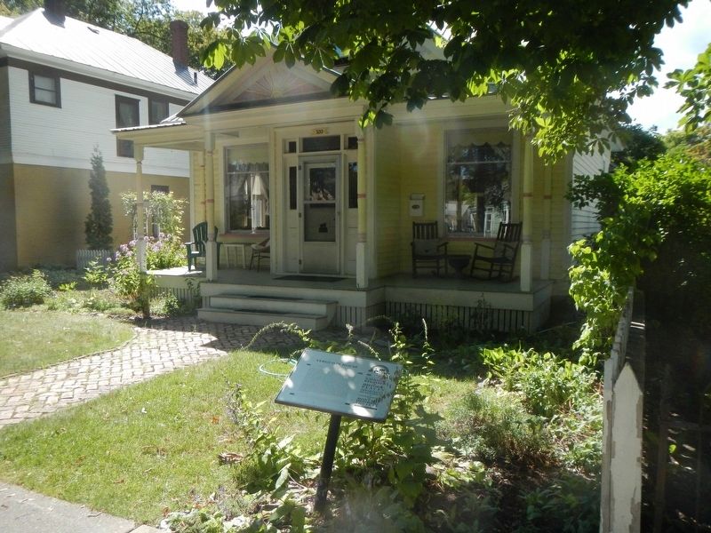
On 3rd Avenue East near 9th Street East, on the left when traveling south.
Isaac Yenne, a carpenter who lived next door, likely built this cross-gable house for his brother George, a Civil War veteran of the 14th Indiana Regiment. The residence originally featured a full-length front porch. Common to the era are the home's . . . — — Map (db m160790) HM
On 4th Avenue East near 6th Street East, on the left when traveling south.
Open-air porches and balustrades on the first and second stories distinguish this transitional residence built circa 1910. At a time when architectural tastes were changing, the home reflects the asymmetrical Victorian-era Queen Anne style of the . . . — — Map (db m160401) HM
Near 4th Avenue East near 2nd Street East, on the right when traveling south.
Carpenter Warren J. Lamb demonstrated familiarity with the very latest styles in this two-story home, which he built in 1898. The low hipped roof and wide eaves suggest the Prairie style while exposed rafter ends are a hallmark of the Arts and . . . — — Map (db m160725) HM
On 2nd Avenue West, on the right when traveling south.
A second-story Palladian window and a full-length front porch (now enclosed) enliven the façade of this house, built in 1910 for Henry and Josephine Hegranes. In that year, a horse stable off the alley was the nearest building to the Hegranes’ . . . — — Map (db m161032) HM
On 3rd Avenue East near 6th Street East, on the right when traveling south.
According to its abstract of title, in 1909 this home was moved to Kalispell from Demersville, four miles away. Dr. William Taylor, a local surgeon, physician, and county coroner, owned the property by 1910. He traded houses and medical practices . . . — — Map (db m160429) HM
On 5th Avenue West near 8th Street West, on the right when traveling south.
Pioneer newspaperman George M. Houtz was the first owner of this stately Italianate style home, built in 1899. Houtz, who had learned the printing trade in Illinois and founded a newspaper in South Dakota, came to Montana in 1891. He and a partner . . . — — Map (db m161034) HM
Near 1st Avenue East near 9th Street East, on the left when traveling south.
Joseph E. Rockwood moved to Kalispell from Missouri in 1901 to begin a long and successful career as a lawyer. He entered into practice with longtime friend F. Joe Rice. And, beginning in 1934, served two terms as judge of the 11th Judicial . . . — — Map (db m160925) HM
On South Main Street at 2nd Street East, on the left when traveling south on South Main Street.
As the tracks of the Great Northern Railway inched westward from St. Paul to Seattle, Flathead Valley towns vied for designation as the railway’s division point. In the spring of 1891, however, railroad officials purchased land from the Reverend . . . — — Map (db m160483) HM
On 2nd Avenue East near 6th Street East, on the left when traveling south.
Irish-born Thomas McGovern built several homes for rental purposes as well as this splendid Queen Anne style residence for his own family. Constructed between 1899 and 1903, its distinctive turret has long been a neighborhood landmark. The mansard . . . — — Map (db m160861) HM
On 6th Avenue East near 4th Street East, on the right when traveling south.
Following new towns that sprang up across Montana, architect Franklin M. Morgan left a trail of buildings he helped construct from Billings to Miles City and Great Falls. Many were the first buildings in these fledgling communities. Morgan moved on . . . — — Map (db m160143) HM
On 2nd Avenue West at 8th Street West, on the left when traveling south on 2nd Avenue West.
While most of Montana lost population during the 1930s, Kalispell grew dramatically as people migrated from areas hard hit by drought and economic depression. Contractors like Herbert Yeaw, who built this one-story, wood-sided home, filled the . . . — — Map (db m161031) HM
Scottish immigrant John Simpson had this two-story home built in 1901 by contractor and lumberman Elmer Bader. Simpson and his wife Minnie lived here off and on with their seven children for many years. Herbert and Johanna Harmon owned and occupied . . . — — Map (db m160923) HM
On 3rd Avenue East at 8th Street East, on the right when traveling south on 3rd Avenue East.
The Colonial Revival style is nicely represented in this early-twentieth-century residence built by Civil War veteran Joseph Stuart. One of Flathead County’s early pioneers, Stuart and his wife Nancy settled in the Flathead Valley in 1886. Stuart . . . — — Map (db m160856) HM
On 2nd Avenue West near 9th Street West, on the right when traveling south.
Belsami Tetrault was born in Montreal, Canada, in 1852 and came with her family by covered wagon to the Flathead Valley in the mid-1880s. Her husband Joseph, also a native of Montreal, left his family in 1881 to work on the railroad in the United . . . — — Map (db m161033) HM
Small farms and orchards dotted the fourteen blocks of this residential neighborhood when the original townsite of Kalispell was platted in 1891. Soon a few wood frame buildings were constructed on its lots for temporary housing and to provide . . . — — Map (db m160967) HM
On 3rd Avenue West at 8th Street West, on the right when traveling south on 3rd Avenue West.
The Flathead Monitor declared in 1899 that the west side was way ahead of the east side with “a new residence being started there about every day.” By 1900, streets and sidewalks had replaced the open prairie. This Queen Anne style home . . . — — Map (db m161035) HM
On U.S. 93, 0.2 miles south of Forest Hill Road (State Highway 82), on the right when traveling north.
Hudson Bay Company (HBC) agent Joseph Howse built a trading post just north of here in 1810, the first European settlement in the valley north of Flathead Lake. Described as “adventurous, tough, and intelligent,” Howse joined the . . . — — Map (db m127682) HM
On U.S. 93, 0.2 miles south of Forest Hill Road (State Highway 82), on the right when traveling north.
In 1901, Great Northern Railway tycoon James J. Hill and local businessman John O'Brien joined forces to build and operate a 11-mile railroad line to a saw-mill on the north shore of Flathead Lake. Hill built this spur line in record time and . . . — — Map (db m127683) HM
On Central Avenue near East 2nd Street, on the left when traveling north.
This Whitefish landmark has a long and colorful history, centering around the Japanese immigrant, M.M. Hori, who had come to the Flathead Valley as a house-boy for the family of Charles Conrad, a major figure in the founding of Kalispell. Conrad . . . — — Map (db m159946) HM
On Lone Mountain Ranch Road near Lone Mountain Trail, on the right when traveling north.
Eastern clients visited dude ranches for authentically western experiences in complete comfort or, as one rancher put it, “home-made bedsteads but forty-pound mattresses.” The B Bar K was no exception. Wealthy Chicagoan J. Fred Butler bought the . . . — — Map (db m192619) HM
On Lone Mountain Trail (State Highway 64) at Little Coyote Road, on the right when traveling west on Lone Mountain Trail.
Frank Crail, County Commissioner from 1889 to 1900, started proving up on his homestead in 1902 at what is now Meadow Village. The ranch became a cattle and wheat ranch of some 960 acres. Crail developed a strain of wheat called Crail Fife. His son . . . — — Map (db m192613) HM
Near Spotted Elk Road near Crail Ranch Drive, on the left when traveling west.
Sweeping views of the Spanish Peaks, the Madison Range, and the Gallatin Canyon provided a magnificent setting for Augustus Frank Crail to locate his ranching headquarters. Crail carved out a 960-acre ranch purchasing three homesteads, school lands, . . . — — Map (db m192616) HM
Near Spotted Elk Road near Crail Ranch Drive, on the left when traveling west.
(Background photograph:)
Barn Complex on the Crail Ranch The barns were clustered in a utilitarian linear plan with the attached system of corrals and outbuildings. — — Map (db m192516) HM
(Background photograph:)
The Beaverslide
Patented in 1910 in the Big Hole Valley, this device stacks hay for outside storage in a wind-proof loaf-shaped stack that could rise 30 feet high and contain up to 20 tons of hay. . . . — — Map (db m192526) HM
Near Spotted Elk Road near Crail Ranch Drive, on the left when traveling west.
The Crail Family amassed 960 acres of Basin (now called the Meadow) that stretched from below the national forest in the north across the Meadow to the South Fork and west to the foothills. This Sweetgrass Hills vantage point captures the expanse of . . . — — Map (db m192525) HM
Near Spotted Elk Road near Crail Ranch Drive, on the left when traveling west.
(Background photograph:)
A string of pack animals is prepared to embark on a trip into the Gallatin wilderness. Locals and visiting "dudes" mounted up and packed out to fish pristine lakes and streams, to view or hunt big game wildlife, . . . — — Map (db m192520) HM
On South 3rd Avenue at West Koch Street, on the right when traveling north on South 3rd Avenue.
A handsome oak stairway is the centerpiece of this beautifully crafted Queen Anne style home built circa 1905. Dr. Louis Safley, a Bozeman physician, may have been the original owner, but prominent Pass Creek rancher Louis Accola and his extended . . . — — Map (db m192178) HM
On East Main Street near North Rouse Avenue, on the right when traveling west.
The grand opening of the Bozeman Hotel and Annex in 1891 brought 500 theater-goers to the celebration. A temporary footbridge was constructed across Main Street between the second stories of the hotel and theater so that quests could come and go . . . — — Map (db m191980) HM
On Interstate 90 at milepost 318, on the right when traveling west.
Sacajawea, the Shoshone woman who guided portions of the Lewis and Clark Expedition led Captain Wm. Clark and his party of ten men over an old buffalo road through this pass on July 15, 1806. They were eastward bound and planned to explore the . . . — — Map (db m162423) HM
On East Main Street near North Rouse Avenue, on the right.
Bozeman's enthusiastic bid to become Montana's capital began upon statehood in 1889 with the construction of impressive buildings here at Rouse Avenue and Main Street. An obstacle facing building contractors was Sour Dough Creek. A fieldstone barrel . . . — — Map (db m191979) HM
Near N. 19th Avenue near I-90 eastbound entrance ramp (at milepost 305), 0.1 miles east of N. 19th Ave. and E. Valley Center Rd., on the left when traveling south.
For centuries distant and diverse tribes visited the Gallatin Valley to hunt. They stampeded buffalo over cliffs during the "dog days" before the acquisition of horses and guns. They hunted animals for food, clothing and shelter. They also mined . . . — — Map (db m29075) HM
On 19th Avenue near I-90 eastbound entrance ramp (at milepost 305), 0.1 miles east of N. 19th Ave. and E. Valley Center Rd., on the left when traveling south.
Conflicts along the Bozeman Trail between Lakota, Northern Cheyenne, and Arapaho Indians and settlers escalated with the establishment of forts along the route in 1866. After Indians killed John Bozeman, in the Yellowstone Valley in 1867, the . . . — — Map (db m29079) HM
On Old Route 191 at Fort Ellis Road when traveling east on Old Route 191.
Established as a military post August 27, 1867 by order of
President Andrew Johnson and General U.S. Grant
the post was abandoned in December 1886
Captain Wm. Clark
of the Lewis and Clark Expedition
encamped here July 14, 1806 with his . . . — — Map (db m98279) HM
On 19th Avenue near I-90 eastbound entrance ramp (at milepost 305), 0.1 miles east of N. 19th Ave. and E. Valley Center Rd., on the left when traveling south.
An abundance of beaver encouraged Corps of Discovery members John Colter and John Potts to return to the headwaters. In 1808, Blackfeet Indians killed Potts in a confrontation and stripped Colter bare, giving him a chance to run for his life. In one . . . — — Map (db m29077) HM
On East Olive Street at Lindley Place, on the left when traveling west on East Olive Street.
This diminutive neighborly district of thirty-four rather modest, early homes was surveyed and platted as Lindley and Guy’s Addition in anticipation of the arrival of the Northern Pacific Railroad. A lumber planing operation occupied the northwest . . . — — Map (db m192152) HM
On North Tracy Avenue at East Villard Street, on the right when traveling north on North Tracy Avenue.
The twenty-eight homes along this stretch of North Tracy Avenue illustrate the extensive residential development that occurred north of Main Street. Impressive homes at 322 and 316 North Tracy, built in 1890 and 1900, and two bungalows at 519 and . . . — — Map (db m192451) HM
On North Wallace Avenue near East Davis Street when traveling north.
As Bozeman made its bid for state capital, the construction of fashionable homes and buildings contributed to the town’s promotional efforts. Economic depression in 1893 and designation of Helena as state capital in 1894 tempered the boomtown . . . — — Map (db m192376) HM
Near N. 19th Avenue near I-90 eastbound entrance ramp (at milepost 305), 0.1 miles east of N. 19th Ave. and E. Valley Center Rd., on the left when traveling south.
The Pioneer Museum, located next to the Gallatin County Courthouse at 317 West Main, was the former County jail. Along with many museum exhibits showcasing the history of Gallatin County is an Historical Research Library. The photo archives, and one . . . — — Map (db m29085) HM
On South 3rd Avenue near West Story Street, on the left when traveling north.
Optimistic Bozeman entrepreneurs John Dickerson, Walter Cooper, and Nelson Story (of cattle drive fame) platted the Park Addition in 1883. Despite the arrival of the Northern Pacific that year, the addition remained undeveloped until the late 1890s, . . . — — Map (db m192180) HM
On Frontage Road (State Highway 191), on the left when traveling east.
On July 14, 1806 Captain William Clark accompanied by 11 members of the expedition party camped about a mile east of here on the flat at the mouth of Kelly Canyon. The next day, Sacajawea guided the party up the canyon on an old buffalo trail to a . . . — — Map (db m98296) HM
Near West Kagy Avenue near South 3rd Avenue, on the left when traveling west.
President Abraham Lincoln signed the Homestead Act into law on May 20, 1862. The Homestead Act declared the, "any citizen or intended citizen could claim 160 acres - one quarter square mile - of surveyed government land. Claimants must 'improve' the . . . — — Map (db m205925) HM
Near West Kagy Avenue at South 3rd Avenue, on the left when traveling west.
The Museum of the Rockies acquired the Tinsley house in 1986, which helped complete the plans for a working Living History Farm exhibit. The house was moved from Willow Creek, MT in one piece and restored to its original 1890s condition. After . . . — — Map (db m205926) HM
On East Main Street near North Taylor Avenue, on the right when traveling west.
Railroad anticipation sparked a frenzied building boom prompting a shortage of brick that postponed completion of this popular watering hole for nearly two years. Begun in 1880, Phil Skeehan’s Tivoli Beer Hall finally opened in 1882. William Beall . . . — — Map (db m192023) HM
On N. 19th Avenue near I-90 eastbound entrance ramp (at milepost 305), 0.1 miles east of N. 19th Ave. and E. Valley Center Rd., on the left when traveling south.
First Peoples utilized the valley for over 11,000 years before the arrival of Lewis & Clark, and the others that would follow. Trails brought cattle and homesteaders to an agricultural paradise. The military followed, defending settlers, consuming . . . — — Map (db m29084) HM
On N. 19th Avenue near I-90 eastbound entrance ramp (at milepost 305), 0.1 miles east of N. 19th Ave. and E. Valley Center Rd., on the left when traveling south.
Settlers came to the Gallatin Valley on the heels of the first Montana gold strike at Grasshopper Creek near Bannack, Montana, in 1862. As Meriwether Lewis had predicted, farmers found the valley well suited for agriculture. They planted crops and . . . — — Map (db m29078) HM
On North Main Street (State Highway 2) at Cottonwood Street, on the right when traveling south on North Main Street.
The Headwaters Region was the setting for the legend of
Colter’s Run
1808
In the fall of 1808 John Colter and John Potts,
both former members of the Lewis and Clark
Expedition, were trapping on the Jefferson
River. Angered by previous . . . — — Map (db m98438) HM
On Frontage Road (County Route 205), on the right when traveling east.
The original townsite of Gallatin City, north of here on the
west side of the combined Madison and Jefferson Rivers,
was selected in 1862. In Feb., 1863 sixty cabins were being
constructed. The river was forded when it was low and a
ferry was . . . — — Map (db m127042) HM
Near Trident Road, 1.5 miles north of Interstate 90, on the right when traveling north.
Built by Jarvis Akin, the Hotel was originally a one-room building of hand-hewn logs. It was the center of Gallatin City's social life; travelers sometimes complained of not being able to sleep because of the ruckus. As the town died, the Hotel was . . . — — Map (db m127043) HM
On Frontage Road (County Route 205), on the right when traveling east.
Approx.. 2 miles north on the Trident Road (#286) is the
confluence of the Jefferson and Madison Rivers. A mile
further downstream you can view the Gallatin River
merging to form the headwaters of the Missouri River, the
longest U.S. river. . . . — — Map (db m99206) HM
On Trident Road (State Highway 286) 1.5 miles north of Interstate 90, on the right when traveling north.
In front of you is the site of Gallatin City, 1865-1880's. After it became obvious that steamboats could not operate economically from Fort Benton to the Headwaters, the town was relocated from the north side of the river to this location. Sitting . . . — — Map (db m126990) HM
Log cabins were introduced to North America by the Swedes and Germans.
Because they were easy to build and made use of readily available materials, log cabins became the most common building on the frontier.
This cabin has dovetail notches and . . . — — Map (db m127044) HM
The Thomas-Frederick Mill was one of two built in the Gallatin Valley during the 1860’s to process locally-grown grains and to guarantee a reliable supply of flour and meal.
Flour from here was freighted regularly to the gold camps of Helena, . . . — — Map (db m127045) HM
On North Main Street at South Main Street, on the right when traveling north on North Main Street.
From 38 to 30 million years ago, great herds of rhinoceros-like herbivores, called Megacerops, roamed this part of Montana. Megacerops, also known as Brontotheres, were massive animals. Classified as Perissodactyla, Megacerops had three . . . — — Map (db m213356) HM
On Trident Road (State Highway 286) 4 miles north of Interstate 90, on the left when traveling north.
In 1908 construction began on Montana’s first cement manufacturing facility. In May 1910, the first cement was shipped to a hardware store in Missoula, Montana. The company-owned village of Trident was built before the plant was completed and at . . . — — Map (db m126996) HM
On U.S. 287, 1 mile south of Willow Creek Road, on the right when traveling south.
The Montana soil is swallowing hundreds of old homestead buildings like this one. Each takes with it untold stories of men and women whose lives brought them drought and blizzards, loneliness and companionship, fear and simple joys, much like we . . . — — Map (db m127000) HM
On South Canyon Street south of Yellowstone Avenue, on the right when traveling south.
A Celebration that Rolled on the Rails
1964 marked 100 years since Montana was established as a territory. How would the state celebrate this milestone? The challenge to develop a unique showpiece led to the idea of a train that would tour the . . . — — Map (db m239711) HM
On Targhee Pass Highway (U.S. 20), on the left when traveling north.
This basin was settled by ranchers and homesteaders.
Bannock Indians had encampments here as late as 1913. Near
here is the west entrance to Yellowstone Park, the nation’s
first National Park(1872). West Yellowstone was founded in
1908 with the . . . — — Map (db m100066) HM
On Meridian Cemetery Road, on the right when traveling north.
The 1804-1806 Lewis and Clark Expedition named this area "Phlosopher's River." Later it was called Windville. As a girl, Sacajawea, a Shoshone Indian, was captured near here by Minnataree Indians. Later she accompanied and interpreted for the Lewis . . . — — Map (db m193005) HM
On Route 200, 1.4 miles east of Garfield/Petroleum County line (Montana Highway 200), on the left when traveling east.
Fort Musselshell was located on the Missouri River about 35 miles north of here. It was a trading post in the ’60s and ’70s and as such had a brief but colorful career. The only whites in that part of the state were woodchoppers for the Missouri . . . — — Map (db m9698) HM
On State Highway 200, 1.4 miles east of Garfield/Petroleum County line.
Competition to supply the mining camps was fierce in Montana in the 1860s. Many opportunists realized that the real money was not in mining for gold, but in “mining the miners” by providing essential goods and services. Fort Benton . . . — — Map (db m9700) HM
On U.S. 89, 0.4 miles south of Heart Butte Road, on the left when traveling south.
The Blackfoot Nation consist of three tribes, the Pikunis or Piegans, the bloods and the Blackfoot. Each tribe is divided into clans marking blood relationship. The majority of the Indians on this reservation are Piegans.
Many years ago the . . . — — Map (db m130198) HM
On I-90 Frontage Road, 1.1 miles east of Bear Gulch Road, on the right when traveling west.
About 350 million years ago, much of Montana was submerged under a shallow sea. Billions of tiny marine creatures thrived in the water and when they died their bodies settled into the muck on the sea bed. After hundreds of millions of years of . . . — — Map (db m71505) HM
On State Highway 1 at milepost 58 near Farm to Market Road, on the left when traveling north.
The Flint Creek Valley has, according to archeologist, been the home to humans for around 10,000 years. Fur trappers and traders frequented the valley in the early 19th century. Prospectors discovered gold in the Granite Mountains and on Henderson . . . — — Map (db m212347) HM
On East Broadway Street east of North Sansome Street, on the left when traveling east.
Built circa 1887, Lutey's Grocery and the Barrett and Jacky Harness Shop originally shared occupancy of this one-story commercial building. By the 1890s, Valentine Jacky shared this building with C. T. Huffman who supplied groceries to Philpsburg . . . — — Map (db m45226) HM
On North Sansome Street at East Kearney Street, on the right when traveling north on North Sansome Street.
The first permanent home for Granite County offices was completed in 1913. Prominent Montana architects John Link and Charles Haire designed the building. Its cut stonework is, appropriately, made of Montana granite. Granite County commissioners . . . — — Map (db m45229) HM
On East Kearney Street east of North Montgomery Street, on the left when traveling east.
The Granite County Jail was constructed in 1896, three years after Granite County was carved from two adjacent counties and Philipsburg made the county seat. The town served as a hub to extensive area mining and, later, ranching. The jail was the . . . — — Map (db m45228) HM
Granite Mtn. Mine located July 6, 1875 and operated by the Granite Mtn. Company.
A rich silver bonanza shoot was discovered in Nov. 1882. The mine closed in 1893 and reopened again in 1911 and 1912 and operated for a brief time. — — Map (db m49540) HM
This two-story building, constructed in about 1885, was one of the first structures in Granite, and housed the brick vault that is seen here. The mining office handled the payroll for the men who worked at the Ruby Shaft and the two mills on the . . . — — Map (db m49629) HM
On East Broadway Street at North Montgomery Street, on the left when traveling east on East Broadway Street.
Michael Kaiser, founder of Philipsburg Water Company, built this grand hotel in 1881. One of Philipsburg's oldest masonry structures, the original hotel boasted a wrap-around porch extending halfway around the building. Second-story French doors, . . . — — Map (db m45218) HM
On East Broadway Street at North Sansome street, on the left when traveling east on East Broadway Street.
Meetings in Philipsburg of Flint Creek Lodge No. 11 date back to 1867. This structure, built in 1911, provided a permanent home for the community-oriented fraternal organization. Chambers for lodge meetings occupy the entire top floor. The ground . . . — — Map (db m45222) HM
Built in 1890 at a cost of $23,000, this three-story building was once the social center of a bustling mining town. The first floor was constructed of native granite. The cast iron front held 6 large windows and small colored glass panes. The upper . . . — — Map (db m49628) HM
On East Broadway Street east of North Montgomery Street, on the left when traveling east.
Colonel J.W. Morse built Morse Hall in 1887. This elaborately detailed public lecture hall also served as county courthouse after 1893, an opera house, town hall, library and general community center. Its splendid second story dance floor was the . . . — — Map (db m45213) HM
On South Sansome Street near East Broadway Street, on the left when traveling south.
Philipsburg's early-day fortunes ebbed and flowed with mining. Today, its historic district is one of Montana's best preserved late-19th-century mining towns, with commercial, public and private buildings dating from the boom period of silver . . . — — Map (db m45209) HM
On East Broadway Street at South Sansome Street, on the right when traveling east on East Broadway Street.
Philipsburg's early-day fortunes ebbed and flowed with mining. Today, its historic district is one of Montana's best preserved late-19th-century mining towns, with commercial, public and private buildings dating from the boom period of silver . . . — — Map (db m45210) HM
On East Broadway Street at South Montgomery Street, on the right when traveling east on East Broadway Street.
One of a network of Jewish merchants who supplied miners in the Rocky Mountain West, nineteen-year-old Benjamin Pizer arrived in Helena from Poland with his wife Jessie Silverman and their newborn son David in 1869. With limited capital, he . . . — — Map (db m45217) HM
On West Broadway Street at North Sansome Street, on the right when traveling west on West Broadway Street.
First known as the Hyde Block, this building was constructed by banker Joseph Hyde and his wife, Mary, in 1888. It housed the First National Bank until the silver crash of 1893. In 1904, Frank Sayrs purchased the building and it has since held a . . . — — Map (db m45220) HM
By 1899, this house stood at the head of Magnolia Avenue, or “Silk Stocking Row,” where the elite of Granite lived. The first floor housed the living quarters for the Superintendent of the Granite Mountain Mining Co. The second floor may . . . — — Map (db m49545) HM
On East Braodway Street east of South Montgomery Street, on the right when traveling east.
Around the mountain from the mining camp of Cable in 1866 came Polish-born merchant William Weinstein with a wagon-load of goods to sell. He became Philipsburg's first general merchant, constructing the eastern half of this building in the late . . . — — Map (db m45212) HM
On West Broadway Street at California Street, on the left when traveling west on West Broadway Street.
Charles A. and Frank J. Wilson, brothers from Wisconsin, built and established their businesses in this building by 1888. The building originally housed a furniture store on one side, a feed store on the other and a miners' boarding house/living . . . — — Map (db m45214) HM
On U.S. 2 near 19th Avenue West, on the left when traveling east.
Cowpunchers, miners, and soldiers are tolerably virile person as a rule. When the went to town in the frontier days seeking surcease from vocational cares and solace in the cup that cheers it was just a well for the urbanites to either brace . . . — — Map (db m142640) HM
On State Highway 2, 3.5 miles south of Interstate 90, on the left when traveling south.
In August 1840, Pierre Jean De Smet, a Catholic missionary of Belgian birth, camped near the mouth of the Boulder River with the Salish Indians and celebrated the holy sacrifice of the Mass. Father De Smet left the Indians soon after to go to St. . . . — — Map (db m128362) HM
On State Highway 282 at Stoney Brook Drive (Virgina Road), on the right when traveling north on State Highway 282.
The Fisk or Northern Overland Expedition camped at the future site of Montana City just east of I-15 in 1862. The outfit, consisting of 125 emigrants, left Minnesota in June, 1862, under the leadership of Capt. James Fisk for the purpose of opening . . . — — Map (db m186275) HM
On Route 518 near U.S. 287, on the left when traveling south.
During the summer of 1864 a wagon train from Iowa heading west for the Oregon country stopped near this site to rest and repair their wagon before crossing the Rocky Mountains.
Among these pioneers were Jonathan and Elmira Manlove and their two . . . — — Map (db m141793) HM
Named for the daughter of a local rancher, Augusta was established on Fred Walrath's homestead in 1884. It prospered as a trade center for a vast cattle and sheep ranching area. By the 1890s, Augusta's main street included dwellings, hotels, . . . — — Map (db m157405) HM
On Reeder's Alley near South Park Avenue, on the right when traveling west.
The second cabin to your right is "The Pioneer Cabin". This cabin was built of hand-hewn logs in 1864, and is one the oldest cabins in Montana. It exemplifies a typical miner's residence of the gold rush era.
"The Pioneer Cabin" has been . . . — — Map (db m187374) HM
On South Rodney Street near East Broadway Street, on the left when traveling north.
A small L-shaped dwelling with a full-length front porch stood on this lot by 1875 according to an early bird’s-eye map of Helena. German Catholic rancher Herman Rosenbaum and his wife Mary purchased the house in 1879. The neighborhood was perfect . . . — — Map (db m188210) HM
On South Park Avenue at Reeder's Alley on South Park Avenue.
According to reminiscences of the Butts family, builders of the Pioneer Cabin next door, two cabins stood on this lot in 1865. William Davenport likely built one for his family and the William H. Parkinsons occupied the other. Sallie Davenport, . . . — — Map (db m187373) HM
On North Last Chance Gulch at East 6th Avenue on North Last Chance Gulch.
On this placer mining claim, gold was discovered on July 14, 1864 by John Cowand and John Crab of Georgia, Bob Stanley of London, England and D.J. Miller of California known as "The Georgians" who were returning from an unsuccessful prospecting . . . — — Map (db m187078) HM
On North Last Chance Gulch near East 6th Avenue, on the left when traveling north.
Before the discovery of cold this valley knew only the Indian or the occasional trapper; however by 1867 nearly 7,000 people had poured into the gulch, Last Chance Mining Camp, became Helena, and a new city was born.
Helena truly became a . . . — — Map (db m186485) HM
On Dearborn Avenue near Power Street when traveling north.
The steamboat Alone brought Stephen Gilpatrick to Montana on the cusp of the 1863 gold rush to Alder Gulch. When mining proved a disappointment, Gilpatrick moved on to Last Chance where he and a partner established the camp’s first stationery store. . . . — — Map (db m187662) HM
On North Last Chance Gulch at West 6th Avenue, on the left when traveling north on North Last Chance Gulch.
Two major areas comprise the Helena Historic District. The first area is roughly bounded by Hauser Boulevard, Monroe Avenue, Stuart Street, Dearborn Avenue, Flowerree Street, and Madison Avenue. The second area is roughly bounded by Neill Avenue, . . . — — Map (db m186276) HM
On Rodney Street at State Street when traveling north on Rodney Street.
This first permanent settlement of the gold camp at Last Chance Gulch offers a glimpse of early Helena from the late 1860s to the 1890s. By the 1870s, a Catholic cathedral, St. John’s Hospital, two schools, and dormitories presided over the district . . . — — Map (db m188182) HM
On West Main Street near Grizzly Gulch Drive, on the right when traveling west.
The physical link between the earliest settlement of Helena and the ceaseless efforts to fully exploit the area’s mineral potential is nowhere more clearly apparent than in this narrow district, settled on mining claims. After the first local gold . . . — — Map (db m187582) HM
On West Main Street near Grizzly Gulch Drive, on the right when traveling west.
English immigrants Frances and Henry Hay came to Helena in the mid-1860s and were among the first to settle on West Main where Hay mined a claim. Their log cabin became the center of the present residence, built circa 1870. A switchback path leads . . . — — Map (db m187578) HM
On East Broadway Street near North Montana Avenue, on the left when traveling west.
he western gold rushes not only lured miners but entrepreneurs seeking business opportunities. Armed with blacksmithing and wagon-making skills, adventurer Joshua Armitage and his wife Martha arrived at Alder Gulch in December 1863. They moved to . . . — — Map (db m187075) HM
On State Street near South Davis Street when traveling west.
A small rectangular gabled dwelling built against a one-room log cabin stood on this spacious corner in the 1870s. The property had changed hands several times when Austrian immigrant Franz Koch, a bookbindery foreman, purchased it in the late . . . — — Map (db m188115) HM
On South Park Avenue at South Cruse Street, on the left when traveling south on South Park Avenue.
The city of Helena started as a group of placer miners' cabins and Main Street follows the bottom of Last Chance Gulch. The gulch is formed by the convergence of Oro Fino and Grizzley Gulches and its colorful history began when gold was discovered . . . — — Map (db m188672) HM
335 entries matched your criteria. Entries 101 through 200 are listed above. ⊲ Previous 100 — Next 100 ⊳