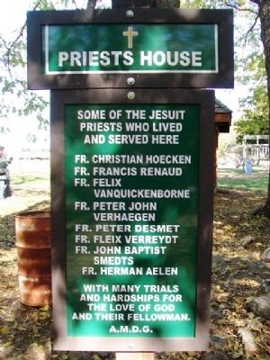
Some of the Jesuit priests who lived and served here
Fr. Christian Hoecken • Fr. Francis Renaud • Fr. Felix Vanquickenborne • Fr. Peter John Verhaegen • Fr. Peter Desmet • Fr. Fleix [sic] Verreydt • Fr. John Baptist Smedts • Fr. Herman Aelen . . . — — Map (db m70638) HM
Kateri was an Indian princess. Her father Kenneronkwa was a chief of the Mohawk-Iroquois (Turtle Clan). Her mother was Kahenta of the Algonquin tribe.
This young Indian maiden is honored on July 14 as the first North American Indian proposed . . . — — Map (db m70641) HM
Sugar Creek Mission
1839 - 1849
Potawatomi Settlement
after a forced march from
Northern Indiana
A Journey Called
"Trail of Death" — — Map (db m70574) HM
This is the Memorial and Historical Park dedicated to St. Philippine Duchesne and the Big Sugar/St. Mary Indian Mission, established 1838 to 1848.
The official Shrine to St. Philippine Duchesne is located in Sacred Heart Catholic Church in . . . — — Map (db m70632) HM
Potawatomi Tribal members were marched from Indiana in 1838 to be relocated on Indian Territory lands. The march was long and arduous. Many Potawatomi, especially children and the elderly, died of illness along the way. Those who survived the . . . — — Map (db m33946) HM
At the end of the Ice Age, about 9000 years ago, people hunted wooly mammoths and ancient bison on the plains of what is now Kansas. They used spears and atlatls, or throwing sticks, and they made beautiful stone points from native flint. They . . . — — Map (db m66121) HM
The stone sculptures before you were [?]ed by [?] Richard Stauffer and produced by the 1992 Kansas Sculptors Association Team Carv[?] [?] to illustrated the theme “Prairie Passage,” reflecting Emporia’s role as gateway to the Flint . . . — — Map (db m43258) HM
In 1825 President James Monroe approved a bill providing for the survey of the Santa Fe Trail from Missouri to New Mexico and the making of treaties to insure friendly relations with Indians along the route. A mile west of this sign, on Dry Turkey . . . — — Map (db m53059) HM
During the first half of the 19th century the U.S. government, in response to public pressure for land and resources, began a program of concentrating Indian tribes on reservations. After the Civil War, an ever growing number of settlers made it . . . — — Map (db m55276) HM
Dedicated to a couple who helped found and shape Paola, Baptiste Peoria, chief of the Confederated Peoria Tribes and his wife Mary Ann Isaacs Dagenet Peoria chose to take a leadership role in developing Paola. Most of the Paola Town Company were . . . — — Map (db m34428) HM
Many moons ago, so runs an Indian legend, Waconda, a beautiful Princess, fell in love with a brave of another tribe. Prevented from marriage by a blood feud, this warrior embroiled the tribes in battle. During the fight an arrow struck him as he . . . — — Map (db m123009) HM
American Indians considered Waconda Springs a sacred site. Translated similarly by other tribes, the name comes from a Kaw word meaning "Great Spirit." The legend tells of the beautiful Waconda who fell in love with the warrior Takota from a . . . — — Map (db m123034) HM
Welcome Visitors
Waconda Springs was said to be known to Native Americans as a ceremonial meeting place for the tribes documented to have used the area. The known tribes are: The Arickanees, Wichita, Sioux, Osage, Kiowas, Arapahoes, . . . — — Map (db m53424) HM
Near this monument March 8, 1862, Captain Richard C. Mason of the 16th Arkansas Cavalry and was severly wounded and his horse killed. Mason was rescued by Frank Colbert a Chickasaw. Mason served for the duration of the war, and received an honorable . . . — — Map (db m57880) HM WM
During the Civil War, militias from both the Union and Confederate sides were stealing the Osages' cattle, harassing their villages, and blaming the Indians for raids actually committed by Americans. Osage leader Charles Mongrain cautioned everyone . . . — — Map (db m60477) HM
Council Grove has been a meeting place for Native Americans, explorers, soldiers and Santa Fe Trail traders. The name "Council Grove" came from treaty negotiations that were conducted here in 1825 between Osage chiefs and U.S. commissioners to . . . — — Map (db m45465) HM
In 1825 growing traffic over the Santa Fe trail brought a government survey and right-of-way treaties with certain Indians. Council Grove takes its name from an agreement made here that year with the Osage nation. Indians farther west continued . . . — — Map (db m44940) HM
Under this tree
the treaty between
the U.S. Commissioners and
the Osage Indians was signed
giving the right of way
forever through their land
establishing the Santa Fe Trail — — Map (db m44971) HM
The hunting grounds of the Kaw (Kansa) and Osage Indians were located here when Americans and Mexicans began hauling trade goods over the Santa Fe Trail in 1821.
In 1825, in response to traders and merchants who eagerly sought trade with . . . — — Map (db m44981) HM
In 1542, Fr. Juan Padilla, a Franciscan Friar, (the First American Martyr), accompanied Coranado on his expedition from Mexico some 50 years after Christopher Columbus landed in the USA and 78 years before our pilgrim . . . — — Map (db m44939) HM
This Kanza warrior stands as a tribute to the tribe for whom the State of Kansas is named. Also known as the Kaws, the Kanzas occupied a reservation in this area from 1848 to 1873. Today's tribal government, the Kaw Nation, is headquartered in Kaw . . . — — Map (db m44825) HM
In 1861 the U.S. government constructed 138 of these stone houses for the Kaw Indians. Contractor Robert S. Stevens built the huts at a total cost of $33,135.98.
The houses were situated on the diminished Kaw Reservation in or near the Neosho . . . — — Map (db m45049) HM
"Great father, you white people treat us like a flock of turkeys. You chase us from one steam and then chase us to another stream and then to another stream. Soon you will chase us over the mountains and into the ocean
- Al-le-ga-wa-ho, . . . — — Map (db m45053) HM
N.S.D.A.R. Memorial
to the
Pioneer Mothers
of the
Covered Wagon Days
The National
Old Trails Road
Here East met West
when the Old Santa Fe Trail
was established August 10, 1825
at a council between the
United . . . — — Map (db m44822) HM
1821 • The Santa Fe Trail is first used by travelers throughout this area.
1827 • Big John Spring, now buried beneath the highway berm 100 ft. south, is discovered and named by George Sibley survey party.
1844 • John C. Fremont's party, . . . — — Map (db m192211) HM
"Only jail in early days on the Santa Fe Trail. Within its walls desperados, border ruffians, and robbers were held. During the Indian Raid of 1859 two Indians were taken out and hanged by a mob. A bad man, Jack McDowell, was hanged from the Neosho . . . — — Map (db m44992) HM
Santa Fe Trail
Marked by the
Daughters of the
American Revolution
and the State of Kansas
Council Grove
On this spot August 10, 1825
the treaty was made with the
Osage Indians
for the right of way of the
Santa Fe . . . — — Map (db m44967) HM
Located about three miles northeast of Chanute on the eastern riverbank at a ford now known as Brown Wells Dam the town of Osage City sprang up in 1856. A man named John Beck and others came to the area from the Tioga River basin in New York. Beck . . . — — Map (db m92301) HM
The first Indian mission and school in present Kansas was established in September, 1824, about five miles west of this marker. Benton Pixley, the missionary, followed Chief White Hair and his band of Great Osages who had migrated from Missouri . . . — — Map (db m46198) HM
Originally from the Ohio Valley, the Osages agreed in 1810 to a treaty to relinquish lands in Missouri and relocate along the Neosho River in Kansas. Under the leadership of Chief Pahuska, called White Hair, the Osages lived and hunted on their . . . — — Map (db m65813) HM
The Oak Grove School was built facing the only road that existed here in 1877 — the Osage Trail. Prior to 1865, the Neosho River valley (including the site where you now stand) was part of the Osage Reservation. At one time a large Osage village . . . — — Map (db m229750) HM
The mission was founded in 1847 for Osage Indians living along the Neosho and Verdigris rivers. A manual labor school for boys was established by the Jesuits and a department for girls by the Sisters of Loretto. Highest recorded enrollment was 239. . . . — — Map (db m46238) HM
Capt. Zebulon M. Pike and Exploring Party passed near here Sept. 22, 1806 en route to the Pawnee village to win tribal allegiance to the United States
One Day's March
Lost Creek Camp [to] First Creek Camp
Pike's Route traced by
Theo. H. . . . — — Map (db m79955) HM
Confrontation Ridge, April 14, 1867 - The Army
History happened here. During the winter of 1866-1867, false rumors spread fears of a major uprising of Plains Indians. Gen Winfield S. Hancock, new department commander who had no . . . — — Map (db m218039) HM
After you cross this bridge over the Pawnee Fork River, you will be able to walk directly into an 1860s Army post. Today no wall of sharpened upright logs surrounds Fort Larned because the Army never put such a wall or other type of stockade here . . . — — Map (db m40158) HM
The Kanza Indians left their homelands east of the Mississippi River during the 1600s. They settled into what is today the northeast part of Kansas. Waterways provided sustenance for their people and were part of the tribe's culture. The success . . . — — Map (db m95883) HM
A few miles to the northwest, the Oregon-California trail crossed the Vermillion Creek heading toward the Pacific from the "jumping off" towns on the Missouri River.
The crossing was named for Louis Vieux, a Potawatomi leader of French and . . . — — Map (db m119123) HM
The “Great Military Road” from Fort Leavenworth to Fort Riley, as well as the Oregon Trail, passed through Saint Mary's in the 1850's. Military traffic, emigrants on their way West, settlers, and stage coach lines also used this route. Stage . . . — — Map (db m122964) HM
These iron gates were originally at the entrance to St. Mary's College. Placed on this site in commemoration of the 150th anniversary of the founding of the St. Mary's Mission
1848 - 1998
————————
An Indian Agency for the Potawatomi was . . . — — Map (db m79198) HM
The Native America tribe that is called the Potawatomi originally lived in the heavily forested region of the northern Great Lakes with their close relatives the Ojibwe and Ottawa tribes in what is now the state of Michigan. The rapidly expanding . . . — — Map (db m34792) HM
This city and college take their name from St. Mary's Catholic Mission founded here by the Jesuits in 1848 for the Pottawatomie Indians. These missionaries, who had lived with the tribe in eastern Kansas from 1838, accompanied the removal to this . . . — — Map (db m122966) HM
Of Pottawatomie Indian and French ancestry, Louis Vieux was an early resident of this area. Probably born near Lake Michigan, Vieux, with a portion of the Pottawatomies, moved to Iowa and later Indianola, Kan., near Topeka. In 1847 or 1848, Vieux . . . — — Map (db m32608) HM
During excavation of the footing for this flag pole the remains of a Stone Age Native American, estimated 1,000 years old, were discovered. The find remains at this location.
This majestic flag pole
is in memory of
Sylvia Hartwich . . . — — Map (db m80950) HM
The vast expanse of High Plains that today encompasses Rawlins County was once home and hunting ground to Cheyenne, Comanche, and Arapaho Indians. With continued railroad construction and the growth of permanent settlements, American westward . . . — — Map (db m176814) HM
Erected by the State of Kansas
1901
To mark the site of the Pawnee Republic where Lieut. Zebulon M. Pike caused the Spanish flag to be lowered and the flag of the United States to be raised
September 29, 1806 — — Map (db m102928) HM
Long before white men settled Kansas this region was the home of Pawnee Indians. French traders in the late 1700's named those along this river the Republican Pawnee in the mistaken belief that their form of government was a republic. From them the . . . — — Map (db m53412) HM
Eighty years before the Pilgrims landed at Plymouth Rock, Spanish explorers visited Kansas. Francisco Vasquez de Coronado, seeking gold in New Mexico, was told of Quivira by an Indian called the Turk. Here were "trees hung with golden bells and . . . — — Map (db m53314) HM
One mile south is the hand-dug well that served the U.S. Cavalry and Santa Fe Trail travelers in the 1860s.
For five days in July, 1864, 600 Indians besieged a trading post near the well and a wagon train nearby. When the attackers tried to . . . — — Map (db m53319) HM
This Cross is erected to the memory of Father Padilla, Franciscan Missionary, who stood with Coronado at the erection of the first Christian Cross on these prairies. Father Padilla devoted his life to the service of the Cross and to the Indians of . . . — — Map (db m53320) HM
First known farmers in this area were the Wichita Indians • • • Francisco Vasquez de Coronado and Father Padilla came in 1541 • • • In 1821 William Becknell started traveling what is now known as the Santa Fe Trail • • • Settlers and a few mules . . . — — Map (db m156401) HM
Governed by
Chief Tatarrax
———————
Discovered by
Coronado 1541
———————
Rediscovered by
J.V. Brower 1896
Erected by
W. J. Griffing
and . . . — — Map (db m80817) HM
When railroads first built across Kansas in the 1860s, Plains Indians inhabited much of the central and western part of the state. They did not welcome the incursion, sensing a danger to the buffalo herds that provided them with food, shelter, and . . . — — Map (db m95588) HM
In Scott County State Park three miles northwest is El Quartelejo, only known Indian pueblo in Kansas. About 1650, it is believed, Taos Indians migrated here to escape Spanish oppression. Later they were persuaded by the Spanish governor to return . . . — — Map (db m67917) HM
This marks the site of the last encounter in the State of Kansas between Native Americans and the United States Troops. Homesick and ill, the Northern Cheyenne under the leadership of Chief Dull Knife and Little Wolf were trying to return to . . . — — Map (db m65978) HM
Reconstructed here are the remains of a seven-room pueblo believed to have been built by Pueblo Indians from New Mexico. According to Spanish records Indians from Taos and Picuris Pueblos, fleeing Spanish rule, joined their Apache allies at a . . . — — Map (db m65952) HM
In 1899, when Prof. H. T. Martin of the University of Kansas made the first archeological excavations of El Cuartelejo, most of the lower part of the original stone work was still in place, as shown in this photograph. Evidences of several other . . . — — Map (db m65975) HM
This marks the site of the
Picurie Indian Pueblo
1604
which became an outpost
of Spanish civilization
and a rendezvous for
French traders prior to
1720 — — Map (db m65914) HM
Although El Cuartelejo is popularly associated with a Puebloan people, during most of its habitation it was actually used by a band of Plains Apache. They were descendants of Indians who came into the Plains from the North probably in late . . . — — Map (db m65954) HM
Stone from the surrounding hills was used to build El Cuartelejo pueblo. The walls were plastered inside and out with adobe and the roof was made of willow poles or brush covered with mud. When first excavated in abundant charcoal, burned tools . . . — — Map (db m65953) HM
In October 1865 hundreds of Plains Indians camped on these prairies to negotiate peace with U.S. government officials. Among them were Chiefs Black Kettle and Seven Bulls (Cheyennes), Little Raven and Big Mouth (Arapahos), Rising Sun and Horse's . . . — — Map (db m61099) HM
When the last red man has vanished from the earth, and his memory is only the shadow of a cloud moving across the prairie, these shores and forests will still hold the spirit of my People, for they love the earth as a newborn loves its mother's . . . — — Map (db m56748) HM
Dedicated to the many veterans who sacrificed for the freedoms we enjoy today.
Flags have traditionally been symbols of persons united in some common association or effort. Within the American heritage, there have been many diverse interests and . . . — — Map (db m56932) HM WM
While the Plains Indians hunted many kinds of animals, their very existence depended on the buffalo. The massive creatures supplied most of the meat for their diet. Every part of the great animal was used. Nothing was wasted. From the buffalo they . . . — — Map (db m56808) HM
The pipe was central to tribal social and ceremonial life. A shared pipe sealed a friendship, a trade agreement, a treaty.
The solemn act of smoking a pipe was usually part of a group ritual or observance, such as in council, in which the pipe . . . — — Map (db m56789) HM
The Plains Indian chief was not an autocratic ruler. The title was honorary, although an exceptionally powerful personality could exert great influence. As a rule, any power exercised within the tribe was done so by the total body of responsible . . . — — Map (db m56790) HM
For the Plains Indian, the sacred hoop was the all-encompassing symbol of the entire world, with one half of the circle representing the physical realm, the other the spiritual. Equally significant was the number four. The four quadrants of the . . . — — Map (db m56749) HM
Animals that appeared in dreams, it was believed, could convey strength to the shield of a warrior. Special medicines made from "dream animals," such as the eagle or buffalo, were tied to the shield or placed under the outer cover. Long pendants of . . . — — Map (db m56753) HM
To the Plains Indians, the eagle was a lord of the air, symbolizing both ferocity and purity. It flies high in the atmosphere where the air is the clearest and where, in the belief of many Indians, the Great Spirit resides. In fact, it was said . . . — — Map (db m56792) HM
Kiowa-Comanche artist Blackbear Bosin donated his famous work, the "Keeper of the Plains," to the citizens of Wichita in May of 1974. The Keeper of the Plains stands at the confluence of the rivers were his ancestors camped. With his face raised to . . . — — Map (db m56726) HM
I have a song to sing,
To our Mother, the Earth,
To our Father, the Sun...
To sing this song
Because
We are all here;
We are all here, as one
The one that makes us all
All...
In the hands of the Great Spirit.
Blackbear Bosin . . . — — Map (db m56750) HM
This unique Indian head was obtained and presented to Wichita High School North by the 1977 Senior Class as a gift from Mrs. Carl (Ethel) Kelley, a pioneer Wichita family.
1977 Senior Class Officers
William B. Williams, Pres.
Dale A. Goss, . . . — — Map (db m60532) HM
There was considerable concern that the addition of a new stripe for each new state would create hopeless confusion. Therefore, Congress established the still current law that provided that after July 4, 1818 the flag would show thirteen stripes . . . — — Map (db m56960) HM
Gathered as a group at night around the fire, the tribe used storytelling to draw the community closer together. In each story lay a lesson. A bit of wisdom for the younger tribal members to carry with them through life. To the Indians, . . . — — Map (db m56821) HM
Wherever they roamed, the people of the praire carried their world with them in the form of a tipi. Its circular ground pattern resembled the larger camp circle as well as the disk of the earth.
An Indian camp was composed of a circle of tipis, . . . — — Map (db m56754) HM
The Plains Indians were inseparable from the land they roamed. The Plains were home to the buffalo, which the tribes followed during all but the winter months. Under the star-filled sky of the prairie, they showed reverence to the Great Spirit . . . — — Map (db m56806) HM
Horses were introduced by the Europeans in the 18th century. They were seen by the Indians as a creature similar to the dog, subservient to man. The Plains people therefore called the animals "big dogs." However, with the horse came new values and . . . — — Map (db m56793) HM
The status of women in Plains culture was decidedly higher than is often assumed. The wife was the joint owner of family property and had general control and custody of the children. Marriages, divorces, places of residence and monetary matters . . . — — Map (db m56827) HM
The Plains Indians drew inspiration and power from their ceremonies. Using sacred prayer songs, objects and dances, accompanied by ritual drumming and rattling, the people created a spiritual atmosphere to induce visions and revelations. . . . — — Map (db m56829) HM
This marker locates the original confluence of the Big and Little Arkansas Rivers. On August 15, 1865, near this point Jesse Chisholm met with the Plains Indian chiefs and headmen to agree on a treaty signing which occurred the following . . . — — Map (db m60589) HM
The bow and arrow was the most natural weapon for the Plains Indian, the tool best suited for hunting buffalo. It was the first plaything given to him as a child. He began to practice before he was even 4 years old. At the age of 8 to 10, he would . . . — — Map (db m56828) HM
Before it became the Kansas capital, Topeka was the seat of a free-state government — an alternative to the official proslavery territorial legislature elected in 1855. These two bodies represented opposing factions in Kansas’ battle over . . . — — Map (db m118962) HM
The Kansa, for whom the state is named, once occupied 20 million acres of land in eastern and northern Kansas. In 1825 the U.S. government reduced the lands to a reservation west of Topeka. In 1846 tribe members were sent to a 256,000 acre . . . — — Map (db m118963) HM
In 1988, elementary school children of Kansas submitted to the Kansas Arts Commission drawings they thought would be the best idea for a sculpture to top the Capitol dome. Sunflowers, eagles, meadowlarks, farmers, cottonwood trees, wheat shocks, . . . — — Map (db m47000) HM
The first Spanish explorers arrived in Kansas in 1541, followed by Lewis and Clark in 1804. Westward migration brought the first white settlers - government agents in 1808 and missionaries in 1825. Oil and gas were discovered in 1851. In 1854, . . . — — Map (db m46995) HM
In the 1850s most Americans were farmers. They relied heavily on kitchen gardens to feed their families. These plots contained herbs and vegetables used for food, medicine, and dying cloth. Yarrow was used to treat colds and oregano to season . . . — — Map (db m48665) HM
Student farm labor was intended to make this boarding school self-supporting. The building, completed in the spring of 1850, housed approximately ninety Indian children. Eleven years later, the school was closed due to funding failures and the . . . — — Map (db m48663) HM
The Kansa tribe inhabited the Kansas River Valley, where it was first encountered by European traders in the early 18th century. Centered around a number of villages, Kansa society possessed a clearly demarcated social structure and rigid gender . . . — — Map (db m47002) HM
Kansas is a land of trails. Even before Kansas became a state in 1861, many people and animals traveled through the area. It is the north-south route for migratory birds. Elk and bison cut paths looking for rivers and other water sources. Native . . . — — Map (db m48660) HM
Anthony A. Ward bought land from Indians - 1854. Site of first sermon preached in Topeka, December 29, 1854.
——————————
Entered on the
National Register
of Historic Places . . . — — Map (db m65038) HM