Civil War Dead
An estimated 700,000 Union and Confederate soldiers died in the Civil War between April 1861 and April 1865. As the death toll rose, the U.S. government struggled with the urgent but unplanned need to bury fallen Union troops. . . . — — Map (db m181389) HM
Woodland Cemetery—The necropolis that in life (Cornelius Volk) did so much to beaut(ify) and make attractive" (Quincy Daily-Herald, 1898). Among significant historical Woodland memorials are the gravestones of Orville and . . . — — Map (db m150258) HM
On 24th Street (Illinois Route 96) at Jersey Street, on the left when traveling south on 24th Street.
On an August night in 1842, Dr. Richard Eells, an active Quincy Abolitionist in the 1830-40's, was transporting a runaway slave named Charley to a safer location when his carriage was stopped near this spot by a posse searching for Charley. . . . — — Map (db m156857) HM
"Here, too, the father of the town, with other men of large renown, are gathered by that reaper stern, who cuts down each and all in turn" (Henry Asbury, Reminiscences of Quincy, Illinois". Referring to the leaders from an earlier . . . — — Map (db m150257) HM
Near South 5th Street south of Madison Street, on the right.
Inscription - North Side of Monument
How sleep the brave, who sink to rest
By all their country's wishes blest!
When Spring, with dewy fingers cold,
Returns to deck their hallow'd mold,
She there shall dress a sweeter sod
Than . . . — — Map (db m150044) HM
Near South 5th Street, 0.1 miles south of Madison Street, on the right when traveling south.
In 1846, a majestic white oak stood on a Mississippi River Bluff on property owned by Quincy founder John Wood. It towered over the trees that surrounded it. When Wood began to plat Woodland, he chose this oak as the point around which the . . . — — Map (db m150048) HM
On Maine Street east of 24th Street (Illinois Route 96), on the right when traveling east.
This property was purchased by the city of Quincy in 1837 for use as a cemetery known as Madison Square. Among those who were buried here are the Mormons who died in 1838-1839 while in Quincy seeking asylum from persecution in Missouri. In 1857 . . . — — Map (db m156862) HM
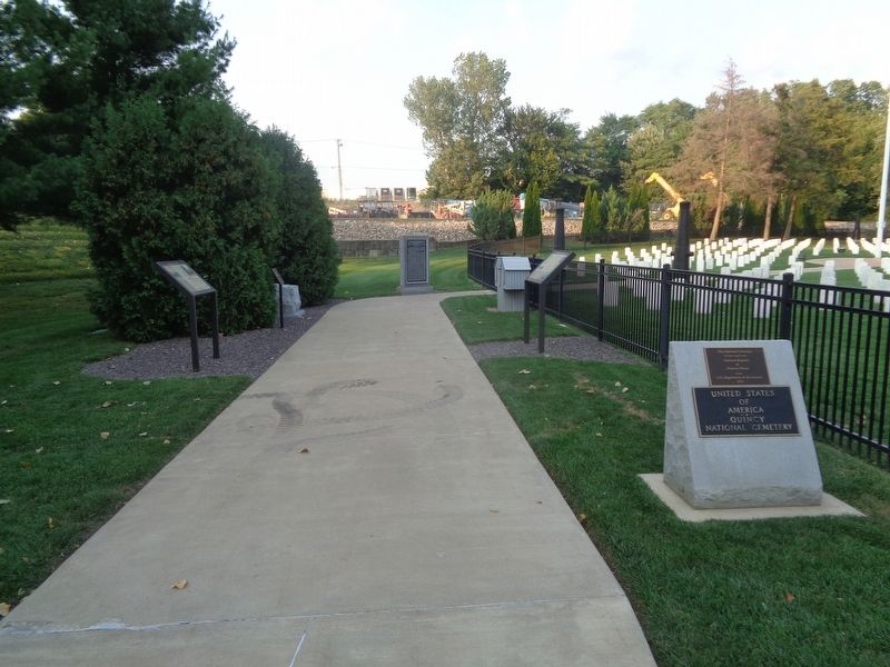
Civil War Quincy
Confederate forces fired on Fort Sumter in South Carolina on April 12, 1861. Three days later, President Abraham Lincoln called for volunteers to suppress the rebellion. Men in Quincy, Illinois, rushed to volunteer for . . . — — Map (db m181384) HM
Near South 5th Street south of Madison Street, on the right when traveling south.
Inscription - South Side of Monument
"Consecrated A.D. 1867 by Sisters of the Good Samaritan in duty, affection, and reverence to the memory of the faithful soldiers of Adams county, who gave their lives that the nation might live." . . . — — Map (db m150045) HM
On Indian Mounds Park west of South 5th Street, on the right when traveling west.
Woodland people invent pottery for food storage and cooking and the bow and arrow for hunting and protection. They live in small villages, and they require raw materials and finished objects through long-distance trade.
They bury their dead . . . — — Map (db m150278) HM
On West Cemetery Road east of Calvin Avenue, on the right when traveling east.
(front:)
"The public does not understand, and I think never will. That almost spiritual fealty that exists between men who go down into the dangers of the mine and work together. That fealty of understanding and brotherhood that exists . . . — — Map (db m186238) HM
Near North 10th Street north of East Alabama Avenue, on the right when traveling north.
With the completion of the National Road (Cumberland Road) through Clark County in 1834, a settlement known as Cumberland was established in this vicinity. The settlement consisted mainly of workmen who moved here for the purpose of securing . . . — — Map (db m188290) HM
On East Lincoln Highway Road west of County Road 1300E, on the right when traveling west.
In Shiloh Cemetery are the graves of Thomas and Sarah Lincoln, father and step-mother of Abraham Lincoln. On January 31, 1861, shortly before assuming the presidency, Lincoln came here from Springfield to visit his father's grave in company with his . . . — — Map (db m188284) HM
Near East Lincoln Highway Road west of County Road 1300E.
Thomas Lincoln, father of the sixteenth President, died in 1851. He was buried in what was then called the Gordon Burial Ground, which today is known as the Thomas Lincoln Cemetery. As was common in many rural cemeteries, Thomas Lincoln's marker . . . — — Map (db m188289) HM
The Old Settlers' Cemetery was established in 1845 by Peter Bohlander. Originally known as the Bohlander Family Burial Grounds, it was part of the Peter Bohlander Farm. This cemetery was donated by Mr. Bohlander for the benefit of his friends and . . . — — Map (db m236967) HM
On State Street at State Line Avenue, on the right when traveling west on State Street.
Two blocks north of this corner the funeral train of President Abraham Lincoln entered Illinois at approximately 10:15 a.m. on May 1, 1865, on the Michigan Central Railroad right-of-way.
In the autumn of 1869, the founders of the State Line . . . — — Map (db m229880) HM
On North Avenue at North Dearborn Street, on the right when traveling west on North Avenue.
Chicago's early Catholic Cemetery ran from North Av. south to Schiller St., and Dearborn St. to the lake, now Astor St. Established in 1845, it existed until the 1871 Chicago Fire charred the grounds. Like the City Cemetery to the north, not all . . . — — Map (db m10665) HM
Near East 67th Street at South Greenwood Avenue, on the right when traveling east.
Confederate Dead
Erected to the memory of the six thousand southern soldiers here buried, who died in Camp Douglas Prison 1862-5.
These men suffered all, sacrificed all, dared all, and died. — — Map (db m63605) WM
Near East 35th Street at South Lake Park Avenue, on the left when traveling east.
United States Senator Stephen Douglas, who died in 1861 at the age of forty-eight, was a firm believer in the future of Chicago. He held states offices and became nationally known for his debating skill in the Senate and in his campaign against . . . — — Map (db m120728) HM
Near East 35th Street at South Lake Park Avenue, on the left when traveling east.
Stephen A. Douglas became a Chicago resident in 1847, moving from central Illinois after his election as U.S. Senator. He intended to build on his lakeside property, named Oakenwald, a gentleman's estate including a mansion, stables, and a . . . — — Map (db m120727) HM
Stephen A. Douglas died June 7, 1861, and was
buried near his Chicago cottage. Friends soon
organized the Douglas Monument Association to
construct a suitable tomb near the site. Work on
the monument, designed by Leonard W. Volk,
began in 1866, . . . — — Map (db m189627) HM
On East 35th Street at South Lake Park Avenue, on the left when traveling east on East 35th Street.
Stephen Arnold Douglas, one of the most distinguished statesmen of his day, was a
Justice of the Illinois Supreme Court, Member of the House of Representatives, and
United States Senator. Although a political rival of Lincoln, he supported the . . . — — Map (db m120707) HM
Lincoln Park was created in response to concerns in the
1850's about the public health threat posed by a lakeside
cemetery. An unused section of the burial ground was
reserved as Lake Park in 186o, and renamed shortly after
President Abraham . . . — — Map (db m189175) HM
On West La Salle Drive (Illinois Route 64) east of Clark Street, on the right when traveling east.
[Front side text:]
Pa wdesgéwen
The Potawatomi word for curious (the act of going about seeking things)
La palabra Potawatomi para la curiosidad (el acto de salir y buscar cosas)
Clues to the Past
History is everywhere . . . — — Map (db m242490) HM
Near North Stockton Drive, on the right when traveling north. Reported missing.
This was the site of the City Cemetery, Chicago's only public graveyard from 1843-1859. Extending from North Av. to Wisconsin St., there were more than 20,000 burials here. For nearly twenty years beginning in 1866, as the grounds were converted to . . . — — Map (db m10660) HM
On West La Salle Street at North Stockton Street, on the right when traveling east on West La Salle Street.
This stone vault is the oldest structure standing within the Chicago Fire zone. It was erected in 1858 for Ira Couch, a wealthy hotelier who died at age 50 while wintering in Cuba. Though some theories exist, there is no official answer as to why . . . — — Map (db m10664) HM
On West LaSalle Drive at North Stockton Drive, on the right when traveling east on West LaSalle Drive.
In 1857, the Couch Brothers, owner’s of Chicago’s Tremont Hotel, built this mausoleum in what was then a public cemetery on the edge of Lake Michigan. Designed by John Van Osdel, Chicago’s first professional architect, the classically-inspired . . . — — Map (db m47814) HM
On North Clark Street at West Wisconsin Street, on the right when traveling north on North Clark Street.
The 1852 funeral for David Kennison was the most elaborate Chicago had ever seen. The City paid all expenses, and donated 2 cemetery lots, intending to erect a monument on his grave. That never happened. The legend of his exploits grew to unfeasible . . . — — Map (db m10657) HM
Near North Clark Street at West Wisconsin Street, on the right when traveling north.
In Memory of
David Kennison
The Last Survivor of the
"Boston Tea Party"
who died in Chicago, February 24, 1852, aged 115 yrs, 3 mos, 17 da, and is buried near this spot.
This stone is erected by the Sons of the Revolution, the Sons . . . — — Map (db m10656) HM
Lincoln Park, named in 1865 for the assassinated President, gradually replaced the 22 year old City Cemetery. This urban cemetery land, already desired for park grounds, was first deemed a health hazard in 1859. That same year officials began . . . — — Map (db m10659) HM
From 1843 to 1871, this area was the City Cemetery potter's field, a graveyard for the poor and disenfranchised. More that 15,000 people, including 4,000 Civil War Rebels, were buried here on marshy land near the water's edge. Within six days in . . . — — Map (db m10663) HM
Near North Ravenswood Avenue at West Rosehill Drive, on the right when traveling south.
Stone River, Farmington, Chickamauga, Jonesborough, Atlanta, Selma, Dallas, Lovejoy, Decatur, Elk River, Nashville
Ringgold, Kenesaw Mountain, Rome, Flat Rock, Noonday Creek, Big Shanty.
Vinings Station, Pulaski, Black Jack Ridge, . . . — — Map (db m81517) WM
Near North Ravenswood Avenue at West Rosehill Drive, on the right when traveling south.
I die for liberty boys.
Go back and man the gun.
O.B. Ft Doneldson.
T.M. Blaisdell 1.Lt. • Jacob Deilman • C.M. Everett 1.Ser. • Sam'l Hadlock • O.E. Beckers • A.H. Beidleman • A.J. Pulz • J.P. Chalman • D.K. Newell • S.C.P. Bogue • Fred . . . — — Map (db m81534) WM
In Memory of
Members of the
Volunteer Fire Department
——————————
Firemens Benevolent Association
Organized 1847
Chartered 1852 . . . — — Map (db m94343) HM
On North Ravenswood Avenue near West Rosehill Drive, on the right when traveling south.
Founder of the United States Railway Mail Service. Put his first railway postal car in use on the Chicago and Northwestern Railway between Chicago, Ill and Clinton, Iowa, August 28th, 1864, under authority from Postmaster Gen. Montgomery Blair. . . . — — Map (db m81514) HM
Born Nov. 4, 1819
in Bavaria, Germany.
Died July 28, 1883
in Chicago, Ill.
A pioneer of German Methodism
in the Northwest; a member of the
Chicago Methodist Conference,
and for 41 yrs. a faithful
Minister of the Gospel
of Jesus . . . — — Map (db m94346) HM
On Ravenswood Avenue at Rosehill Drive, on the left when traveling north on Ravenswood Avenue.
Designed by the architect of the Old Chicago Water Tower and predating it by five years, the Rosehill Cemetery Entrance is a rare Midwestern example of castellated Gothic architecture. Many prominent Chicagoans are buried here in plots marked by . . . — — Map (db m94331) HM
Born Norwich Vt.
Nov. 29, 1834
Died Near Rome Ga.
Oct. 29, 1864
Charleston • Ft. Donelson
Shiloh • Corinth
Champion Hills Miss
Vicksburg
Pleasant Hill La — — Map (db m94333) WM
On North Clark Street at West Ainslie Street, on the left when traveling south on North Clark Street.
(German)
Zum andenken an die heldenmuthige thellnahme der Deutschen an der vertheidigung des neuen vaterlandes im Amerkanischen Burgerkriege
1861-65
Enthullt am 30 Mai 1887
(English)
In memory of the heroic Germans who . . . — — Map (db m81518) WM
Near East 67th Street at South Greenwood Avenue, on the right when traveling east.
Camp Douglas Prison
Camp Douglas was established as a Union training camp on the south side of Chicago. When Fort Donelson, a Confederate stronghold on the Cumberland River west of Clarksville, Tennessee, surrendered in February 1862, the . . . — — Map (db m232642) HM
On Center Avenue, on the right when traveling north.
In memory of
Allan Pinkerton,
born in Glascow, Scotland,
August 25th 1819.
Died in Chicago, Illinois,
July 1st 1884.
Aged 65 years.
A friend to honesty
and a foe to crime,
devoting himself for a generation to the prevention . . . — — Map (db m61986) HM
On Lake Avenue at Evergreen Avenue, in the median on Lake Avenue.
The Getty Tomb marks the maturity of [Louis] Sullivan's architectural style and the beginning of modern architecture in America. Here the architect departed from historic precedent to create a building of strong geometric massing, detailed with . . . — — Map (db m94392) HM
On Evergreen Avenue, on the right when traveling north.
Erected by Henry Graves,
son of Dexter Graves, one of the pioneers of Chicago. Dexter Graves brought the first colony to Chicago, consisting of thirteen families arriving here July 15th, 1831 from Ashtabula, Ohio, on the schooner Telegraph and . . . — — Map (db m94353) HM
On Lake Avenue north of Main Avenue, on the right when traveling north.
By his buildings great in influence and power; his drawings unsurpassed in originality and beauty; his writings rich in poetry and prophesy; his teachings persuasive and eloquent; his philosophy where, in "form follows function," he summed up all . . . — — Map (db m94373) HM
Near Roosevelt Road west of Des Plaines Avenue when traveling west.
This flag and flagpole is a memorial to the veterans of all the branches of service of our nation who are laid to rest in Forest Home Cemetery
May they rest in honor with God's blessing
Dedicated by the War Veterans
Council of Oak . . . — — Map (db m231668) WM
[Plaque on east-facing side of monument:]
In loving memory
of past commander Wilbur F. Crummer
and his comrades here buried
of other comrades of the post buried
in Forest Home Cemetery
of all deceased comrades of the post wherever buried . . . — — Map (db m241587) WM
On Roosevelt Road (Illinois Route 38) 0.7 miles west of Mannheim Road (U.S. 12/45).
Jewish War Veterans of the United States — Department of Illinois
To all who served our country at home or on foreign soil
May they rest in peace
Yarmo ☆ DeVere
Post No. 469
Department of Illinois
In memoriam
Commemorative . . . — — Map (db m245291) WM
Near South Wolf Road, 0.3 miles south of Roosevelt Road (Illinois Route 38), on the right when traveling west.
Consecrated on September 14th, 1947 by Samuel Cardinal Stritch, Queen of Heaven Cemetery opened as a successor to Mount Carmel Cemetery, located across Roosevelt Road. Queen of Heaven paved the way as a "modern" cemetery with the introduction of . . . — — Map (db m245313) HM
On South Wolf Road, 0.4 miles south of Roosevelt Road (Illinois Route 38).
St. Charles Borromeo
1538–1584
The Pious Society of the Fathers of St. Charles was founded in 1887 by Bishop J.B. Scalabrini for the assistance to the Italians throughout the world. It's members are working in Europe, North and South America and . . . — — Map (db m245316) HM
On Thatcher Avenue near Belmont Avenue, on the right when traveling south.
[South-facing, western tablet:]
Matthew, a Galilean tax-collector and one of the twelve apostles, was the author of the first Gospel, which he wrote in his native Aramaic for the Jews of his time, probably around 42 A.D. After preaching in . . . — — Map (db m245108) HM
Near West Belmont Avenue west of Thatcher Avenue, on the right when traveling east.
Consecrated on August 28, 1904 by Archbishop Quigley, St. Joseph Cemetery was opened by the German Angel Guardian Society as a replacement for Saint Boniface Cemetery.
When the gates opened, St Joseph's became one of the largest and most active . . . — — Map (db m245105) HM
In Memoriam
F. Rawlings • F. Scheltens • F. Sprow • A. Jans • W. Sochnuk • G. Niziolek • S. Smith • H. Dieboldt • G. Dewire • H. Zimmerman • H. Olejnik • E. McFadden • J. Hanssen • F. Vojak • F. Romaszko • R. Bobrowski • R. Schubert • E. Roeder • . . . — — Map (db m245107) WM
Near Archer Avenue (Illinois Route 171) east of Kingery Highway (Illinois Route 83), on the right when traveling east.
St. James at Sag Bridge Church & Cemetery. Listed on the National Register of Historic Places. Parish founded 1833. Present church built 1853 — — Map (db m203578) HM
On Woodlawn Street west of Quincy Street, on the right when traveling west.
Left Section
When Lincoln called for troops to defend the Union, the men and boys of DeWitt County heeded his urgent request. Some who volunteered were from families who had know and befriended Lincoln during his days as a prairie lawyer . . . — — Map (db m24253) HM
On Main Street, 0.1 miles south of Curtiss Street, on the right when traveling south.
In 1856, Samuel Curtiss donated part of his sheep pasture for use as a cemetery. He was later paid $15 for the land, money from individuals who formed a cemetery association in 1864. Nearly 100 members of Downers Grove's early families, including . . . — — Map (db m60038) HM
In the early days this was the entrance to the cemetery since the original Main Street was one block west of present day Main Street. For this reason, as you will note, most of the inscriptions on the gravestones are facing west.
As a result of . . . — — Map (db m60039) HM
Near South Washington Street south of West Hillside Road, on the right when traveling south.
John Dudley was born February 25, 1758 in Old Saybrook, Connecticut. In 1776 at the age of 18, he enlisted in the New Hampshire militia and served at Fort Ticonderoga in Colonel Reed's Regiment. There Dudley and the rest of the American troops . . . — — Map (db m230990) HM WM
On 850N east of County Road 315 E, on the right when traveling west.
The former village of Wanborough, Illinois, was established in August 1818 by English settler and entrepreneur Morris Birkbeck. A center of commerce for his fellow countrymen emigrating to the English settlement in Edwards County, Wanborough once . . . — — Map (db m177846) HM
On 300th Street, 0.2 miles north of Jackson Street, on the left when traveling north.
To Those Who Gave All --
We honor and pray for eternal rest.
To Those Who Are Missing In Action --
We express remembrance and hope.
To Those Who Were Wounded In Action -
We honor you.
To Those Who Were Prisoners of War . . . — — Map (db m59438) HM
On East Cumberland Road (U.S. 40) at South 3rd Street, on the right when traveling east on East Cumberland Road.
Nearly 100 years before Brownstown businesses offered fuel, food, and lodging to motorists following US 40 across America, there was Ezra Griffith and Twin Pumps.
A New York native, Griffith followed the National Road to Fayette County, Ill., . . . — — Map (db m144228) HM
Born in Pennsylvania. First store keeper in Vandalia for owner, William Kinney. House of Representatives 1828-29. Registrar of Vandalia Land Office. State Bank Commissioner 1835. — — Map (db m42410) HM
Born in Kentucky. Father of James W. Berry. Territorial Auditor. State Auditor of Public Accounts 1819-31. Co-Editor of "Illinois Intelligencer", Kaskaskia 1817-20. President of State Bank 1837. Black Hawk War soldier. Father-in-law of Gov. W. L. . . . — — Map (db m42383) HM
Born in Hanover. Leader of Colony from Hanover, Germany. Came to Vandalia in 1819 with Frederick Hollman, who remained to build houses. Bearing all expenses, Ernst returned with colonists December, 1820. Director of State Bank, 1821. Trustee of . . . — — Map (db m42380) HM
Born in Hanover. Member of Ernst Colony. Merchant. Paymaster in Blackhawk War 1832. Division Quarter Master in Illinois Militia - Colonel 1834. House of Representatives 1846-48. — — Map (db m42411) HM
Born in Hanover. Died Feb. 3, 1847. Member of Ernst Colony. Builder and operator of Vandalia Hotel. Merchant. Daughter, Olivia Whiteman, friend of the Abraham Lincoln family, unveiled Madonna of the Trail statue. — — Map (db m42384) HM
Half an acre of this Old State Burial Ground was laid off for state officials in 1835. Although exact location is unknown, it is thought to be in this area. In 1874 the monument and remains were moved to South Hill Cemetery. Four Representatives . . . — — Map (db m42421) HM
John B. E. Canal
A representative from
Madison County in the
General Assembly of Illinois
Born at Baltimore
June 24, 1809
Died at Vandalia
December 31, 1830
Benjamin A. Clark
Representative of the
General Assembly . . . — — Map (db m42627) HM
Born in Kentucky. Circuit Clerk of Fayette County 1826-56. Adjutant General 1834-39. First talented artist of Illinois. Portrait painter of state officers and legislators. Commissioned by General Assembly to copy portraits of Washington and . . . — — Map (db m42381) HM
Dr. Morey was born in Erie Co. Penna. but moved to Illinois when a young man. He was nearly 50 yrs. old at his death and had been engaged in the practice of medicine for nearly thirty years.
He graduated from the Physio-Medical College of Ohio . . . — — Map (db m42700) HM
On June 12, 1823, the Third General Assembly, meeting in the newly formed city of Vandalia, conveyed one and one-half acres of land to the city of Vandalia, with the proviso that the land be used as a burial ground. This is the location of that . . . — — Map (db m42428) HM
Wife, born in Kentucky, and son of James Hall, first Man of Letters in Illinois. State Treasurer 1827-31. President of first state historical society 1827-33. Author of first book of literary style in Illinois 1828. Trustee of Illinois College . . . — — Map (db m42388) HM
On Edwards Street at 3rd Street, on the right when traveling east on Edwards Street.
The Illinois General Assembly authorized Governor Edward Coles in 1823 to convey to Vandalia one and one-half acres for a state burial ground. Here were buried four members of the legislature and several state officials who died while in office. . . . — — Map (db m42371) HM
Born in Kentucky. State Printer. Publisher of Laws of United States. Editor of newspaper "Illinois Intelligencer" 1825-32 and Co-Owner with James Hall 1829-32. House of Representatives 1832. Senate 1838-40. Black Hawk War soldier. . . . — — Map (db m42376) HM
Born in Virginia. State Treasurer 1819-23. Trustee of Vandalia appointed by Legislature 1821. House of Representatives 1826-28. Senate 1828-32 and 1836-38. State Bank Commissioner 1835-37. Registrar of U.S. Land Office. Isabella, niece of Shadrach . . . — — Map (db m42423) HM
Born in Maryland. Clerk of First General Assembly of Illinois Territory, Kaskaskia 1812. Clerk of House of Representatives and of Legislative Council, 1815. Clerk of Constitutional Convention 1818. Secretary of Senate 1818-20. Chief Surveyor of . . . — — Map (db m42374) HM
On 5th Street (U.S. 67) just north of South Main Street, on the left when traveling north.
Thomas Carlin, sixth elected Governor of Illinois (1838-1842), was an early settler of Illinois and a prominent figure in organizing Greene County and establishing Carrollton as its county seat in 1821.
Born in Kentucky in 1789, Carlin came to . . . — — Map (db m142746) HM
On Liberty Street just south of East Washington Street, on the right when traveling north.
Erected prior to 1700, over the grave of Chief Nucquette, near foot of Wauponsee Street, Morris.——— Moved by City Council — 1925 — — Map (db m232999) HM
Forty acres of land were acquired by the Catholic church in the early 1830's from land in the Military Tract, which had been set aside for the veteran survivors of the War of 1812. Title to this land on the Southeast Quarter of the Northeast . . . — — Map (db m181443) HM
On West Main Street (Illinois Route 9) west of Center Street, on the right when traveling east.
Abraham Lincoln came into LaHarpe from the west, riding in a phaeton borrowed from Daniel Bainter. There were some dissenters along his parade route. He spoke at the Methodist Episcopal Church, the so-called "Little Church Around the Corner," . . . — — Map (db m181448) HM
Joseph, Sr., and Lucy Mack Smith, parents of the prophet Joseph and the patriarch Hyrum. Descended from industrious and religious New England families. From the beginning of the restoration, they consistently filled supportive roles in establishing . . . — — Map (db m244533) HM
The founder of the restoration. His wife and his brother possessed an enduring love and devotion toward each other.
Joseph once described the bond between himself and Hyrum as "Love that is stronger than death."
Joseph and Emma's marriage . . . — — Map (db m244534) HM
On Water Street west of Main Street, on the right when traveling east.
The Smith Family Cemetery is the final resting place of Joseph Smith, his wife Emma, and brother Hyrum, Lucy Mack and Joseph Smith Sr., and many other family members and friends.
After Joseph and Hyrum were assassinated at the Carthage jail on . . . — — Map (db m244536) HM
On Main Street (Illinois Route 34) at 2nd Street, on the right when traveling east on Main Street.
Travel the Byway and discover the importance of the Ohio River to the nation and the world. Experience the magnificent natural landscapes of southern Illinois while coming to know how the historic events and people that shaped the region and the . . . — — Map (db m196762) HM
On North 5th Street north of Mercer Street, on the right when traveling north.
This memorial is dedicated in memory of an elephant named Norma Jean, who was killed by lightning at this location and lies buried here. — — Map (db m181372) HM