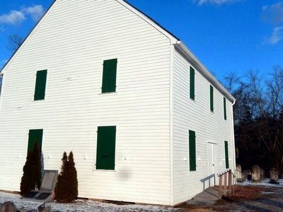
(Top marker) Society Founded 1780, Church Built 1792-First Trustees; David Sayres, Judah Swain, William Smith, Constance Smith, John Champion John Corson, William Goff.
(Bottom left marker) The Head of the River Methodist Episcopal Church is on . . . — — Map (db m92376) HM
Across this driveway stood the old Quaker (Friends) meeting house and school. At the monthly meeting of the Friends dated Jan. 1, 1731, it was concluded that “ye meeting for worship shall be removed from John Sculls (house) and shall . . . — — Map (db m92416) HM
On New York Road (U.S. 9) at Chestnut Neck Road (County Route 575), on the right when traveling north on New York Road.
The first settlement in what is now known as Atlantic County was made at Chestnut Neck, on the west bank of the Mullica River, near where the village of Port Republic is now located. In 1637, John Mullica sailed up the river that took his name, . . . — — Map (db m76179) HM
Due to its location on the water, this area has historically been a transportation hub. In 1717, John Somers, Supervisor of Roads for Cape May County, began work on the Nacote Trail. Now known as Shore Road, it connects Somers Point with Port . . . — — Map (db m64291) HM
Somers Mansion, thought to be the oldest house in Atlantic County, was built in the early 1720’s. The first record of the house is in the Meeting minutes of the Great Egg Harbor/Cape May Society of Friends in 1726 when the group met at the home . . . — — Map (db m64293) HM
On Closter Dock Road (County Route 502) at Old Dock Road, on the right when traveling west on Closter Dock Road.
Laid out in 1761 by New York over an earlier route when that province claimed jurisdiction over this area. Used by troops during the Revolutionary War, the road led from Closter to Closter Dock on the Hudson where farm produce was shipped to New . . . — — Map (db m7208) HM
Near Henry Hudson Drive, on the left when traveling south.
Lower Closter or New DockHere a British invasion force of 5,000 troops commanded by Lord Cornwallis landed before dawn on November 20, 1776. Guided by three Bergen County residents, Joseph Hawkins, Isaac Perkins, and John Aldington, they climbed . . . — — Map (db m142465) HM
On Cedar Street, on the left when traveling north.
Francis Jackson, a freed slave, purchased 7 ¾ acres of woodland here in 1868. Later it would include the black cemetery and “a plain neat little church” built about 1873. The Pastor, Rev. Nicholas Fr. Jackson, lived nearby. The cemetery had 72 . . . — — Map (db m7509) HM
On West Church Street, on the right when traveling west.
Organized in 1723 as the Schraalenburg Dutch Reformed Church. First church erected in 1728, 150 feet to the east, the present building in 1799. The True Reformed Church was founded here in 1822. The church became Presbyterian in 1913. John Henry . . . — — Map (db m7506) HM
On West Fort Lee Road at River Road, on the left when traveling west on West Fort Lee Road.
In 1642, when this area was part of New Netherland, Johannes Winckelman built near here a ninety-foot long fur trading post and farmhouse – a building which sheltered both settlers and cattle. During the 1643 Indian war it was protected by five . . . — — Map (db m7128) HM
This final resting place of early Closter settlers was established by Barent and Resolvert Nagel on their 1,030-acre tract jointly purchased in 1710. The first burial is believed to be Jan Adriansen, c. 1721. The Nagel brothers divided their land . . . — — Map (db m63546) HM
On Harvard Street, on the left when traveling east.
Built about 1745 on land purchased in 1710 by Barent and Resolvert Nagel. The frame wing was added later. Owned by Barent’s son John by 1754 and later by grandson David Naugle, a militiaman during the Revolutionary War. In about 1784 David built a . . . — — Map (db m7910) HM
On County Road (County Route 501) at Madison Ave, on the right when traveling north on County Road.
In colonial times a crude road led from here to a landing at the Hudson River. According to the reports and maps of Generals Erskine and Wayne this road was used by Cornwallis in attacking Fort Lee on November 20, 1776. On May 10, 1779 it was used . . . — — Map (db m7206) HM
On Everett Road at Bogert Road, on the right when traveling east on Everett Road.
Sautes Tave’s Begraven Ground Pre-Revolutionary Cemetery Placed by David Demarest Chapter Daughters of the American Revolution May 30th, 1957 — — Map (db m63548) HM
On Washington Avenue at Madison Avenue, on the left when traveling north on Washington Avenue.
Organized in 1723 as the Schraalenburgh Reformed Dutch Church. First church was built in 1728. In 1801 the present Old North Reformed Church was built, one mile north of first site, and continues as a Reformed congregation. This sanctuary is . . . — — Map (db m7486) HM
On River Road near Glenwood Avenue, on the left when traveling south.
"Vriessendael"
1640
Colony of David DeVries
The first known colony in present Bergen County was founded in 1640 by David Pietersz DeVries, a Dutch explorer, sea captain and patroon. Then part of New Netherland, the plantation included the . . . — — Map (db m38959) HM
On Kinderkamack Road (County Route 503) at Linwood Avenue, on the right when traveling south on Kinderkamack Road.
An area which in colonial times included part of Emerson, Kinderkamack extended southward into part of River Edge. The name is found recorded as early as 1686. This portion became Etna in the late 19th century and Emerson in 1909. The road which . . . — — Map (db m8634) HM
On Grand Avenue (County Route 501), on the right when traveling north.
Built about 1808 by Henry DeMott, this sandstone Dutch Colonial house was once attached to the pre-Revolutionary homestead of Albert Lydecker. Material from the older house used in the present frame wing built c. 1810 by Peter Westervelt. The . . . — — Map (db m7133) HM
On Dunkerhook Road, on the left when traveling north.
This colonial home was built in the 18th century by a Naugle. He was said to have been a paymaster in Layayette’s Light Division. The house served as a landmark on many Revolutionary War maps. It is believed that Lafayette visited here in 1824. . . . — — Map (db m63050) HM
On Franklin Avenue, on the right when traveling west.
Originated as an Indian trail across land the Redmen called “Campgaw”. It was surveyed during the Revolutionary War by Robert Erskine, George Washington’s mapmaker, and connected settlements in the Ramapo and Saddle River Valleys. Franklin Lakes . . . — — Map (db m12395) HM
On Franklin Lake Road west of Wyandotte Dr., on the left when traveling west.
Known to the Indians as “Michanagrape,” these waters were formed by the melting glacier some 10,000 years ago. In 1700 the lake was named Christian Pool when it was included in a land grant to Michael Hawden. Later called Great Pond, . . . — — Map (db m52941) HM
On Moore Street at Court Street, on the left when traveling south on Moore Street.
Archibald Campbell – 1730 – 12/28/1798, age 68. Born on the Isle of Man, came to Hackensack in 1765. Tavern keeper, host to General George Washington. Hackensack’s first Postmaster. Exemplary in all the duties of life, a . . . — — Map (db m62947) HM
On Court Street at Moore Street, on the right when traveling east on Court Street.
[Bergen County Court House Side]:
James Riely Gordon (1863–1937), noted architect of public buildings used the Beaux Arts style to reflect the power and dignity of American institutions of government and justice. Ground was broken . . . — — Map (db m6869) HM
On Washington Place at Main Street, on the left when traveling east on Washington Place.
The first house built in the City of Hackensack was that of Dr. Van Emburgh (1686) located along a creek at the rear of the Court House. Early settlers had huts on this creek where they traded furs with the Indians. — — Map (db m62938) HM
On Main Street at Washington Place, on the right when traveling north on Main Street.
Hackensack became the County Seat of Bergen in 1709. The name “Bergen” was probably from “Bergen Op Zoom,” a major town in Holland. — — Map (db m62937) HM
On Court St. at Church St., on the left when traveling east on Court St..
Earliest records of this pioneer Dutch church, dated 1686, mark it as the second oldest in New Jersey. Old stones embedded in the east wall show the initials of founding families and first settlers.
The old burying ground contains the grave of . . . — — Map (db m6820) HM
Built in 1818, by John I. Hopper in old “Polifly”, this Federal style house stands on land purchased in 1694 by his great-grandfather Hendrick. The farm remained in the Hopper family for seven generations. Slaves lived in the kitchen . . . — — Map (db m6864) HM
Hackensack was a small village centered around The Green which served as a strategic point during the American Revolution.
Washington headquartered here in November 1776 while he surveyed the local roads and bridges. — — Map (db m6867) HM
On Moore Street near Court Street, on the left when traveling south.
In honor of The Huguenots on the Hackensack 1677 --------------- Erected by The Society of Colonial Wars in the State of New Jersey 1942 — — Map (db m62942) HM
On Lafayette Road at Hackensack Avenue, on the right when traveling north on Lafayette Road.
Homestead of Isaac Blanch from about 1758 and site of his grist mill, both inherited in 1767 from his father, Richard Blanch, a native of England. Isaac was a Patriot official and member of the State Assembly during the Revolutionary War. He was . . . — — Map (db m7920) HM
In use for nearly two hundred years, largely by the Blauvelt family, the earliest known burial was in 1722. The cemetery contains the graves of members of other early Bergen County families, veterans of the American Revolution and slaves. Some of . . . — — Map (db m7877) HM
On Harriot Avenue at Bogerts Mill Road, on the left when traveling east on Harriot Avenue.
Abraham Myers established a grist mill at this site on the Hackensack River prior to 1765. Inherited by son John who operated the mill until his death in 1829, it was continued by his son-in-law James Bogert. Long known as “Bogert’s Mill”, it . . . — — Map (db m7940) HM
On Harriot Avenue at Lafayette Road, on the left when traveling east on Harriot Avenue.
Frederick Wortendyke owned this land in 1723. It was once part of a large grant called the Tappan Patent. His son Jacob, who owned the homestead during the Revolutionary War, was taken captive in one of many British raids made in the area. Later . . . — — Map (db m8683) HM
On Terrace Avenue at Main Street, on the right when traveling south on Terrace Avenue.
Polifly Road, this park’s easterly line, was the first public road on Polifly Ridge, from Rutherford to Hackensack. It was projected in 1682 by Capt. John Berry, then Highway Commissioner, and was laid out in March, 1707. Hasbrouck Heights was part . . . — — Map (db m32035) HM
On Schraalenburgh Road at Massachusetts Avenue, on the right when traveling south on Schraalenburgh Road.
Beginning as an Indian trail, it became a Colonial road through the village of Schraalenburgh, linking Teaneck with Tappan, N.Y. Surveyed and improved in 1775, it appeared on maps made during the Revolutionary War by Americans, French and British. . . . — — Map (db m7879) HM
On Pascack Road at Wierimus Lane, on the left when traveling north on Pascack Road.
Built about 1796 by John H. Banta on a tract bought in 1755 where he had an earlier house. Banta was a carpenter and farmer who enlarged his homestead to 395 acres. At the time of the French and Indian War he served as a captain in the Bergen . . . — — Map (db m22251) HM
On Ell Road near Jan Court, on the left when traveling east.
Located in “Pascack” on land inherited from his father, Garret Durie built this house about 1767. During the Revolutionary War, the house was plundered by both American and British armies. Durie was a farmer and a blacksmith as well as . . . — — Map (db m43787) HM
On Hillsdale Avenue, on the right when traveling east.
About 1756 Peter Westervelt built a small house, enlarged in 1785, on land of his wife Catlyntje Haring. During the Revolutionary War the farm was raided. Later it was owned by son Henry and his son Aaron, a Freeholder and State Assemblyman. . . . — — Map (db m43786) HM
On Hillside Avenue, on the right when traveling east.
Site of the Dutch Reformed Church of the English Neighborhood Built in 1768-9 and dedicated in 1770, with Dominie Garrett Lydecker its first minister.
Used as a guardhouse and hospital at various times during the Revolution. Torn . . . — — Map (db m7335) HM
On Grand Avenue at Lakeview Avenue, on the left when traveling north on Grand Avenue.
For 200 years this avenue was the English Neighborhood Road. In colonial days it was the main inland highway between Paulus Hook, Bergen and the English Neighborhood. — — Map (db m40770) HM
On Broad Avenue at Lakeview Avenue, on the left when traveling north on Broad Avenue.
In colonial times this was the site of a slave burial ground. In 1784 slaves comprised almost one forth of the population of the township. — — Map (db m7462) HM
On Lakeview Drive, on the right when traveling west.
Located in old English Neighborhood on land purchased by Dirck Vreeland before the Revolution, the homestead stretched between the Hudson River and Overpeck Creek. The stone wing of this house was built about 1786 and later was remodeled. Son . . . — — Map (db m7131) HM
On Grand Avenue (County Route 93) at W Oakdene Avenue, on the right when traveling north on Grand Avenue.
This section of Leonia was purchased from the Indians by Captain John Berry under a patent dated 1669. Capt. Berry was governor of Nova Caesarea (New Jersey) 1672-3. — — Map (db m54806) HM
On Broad Avenue at W Oakdene Avenue, on the left when traveling south on Broad Avenue.
This section of Leonia is part of a tract purchased in 1668 from the Hackensack Indians by Samuel Edsall and Nicholas Varlett who founded the English Neighborhood. — — Map (db m54847) HM
On Ramapo Valley Road (U.S. 202), on the right when traveling south.
Built as a gristmill about 1760 by Lambartus Laroe and sold to Thomas Boggs in 1764, it had a pair of millstones. Boggs also ran a tavern in his nearby home. Owned by David Baldwin during the Revolution, the mill ground grain for American troops. . . . — — Map (db m24991) HM
In 1713, eleven German Palatine families settled in this area and organized into a congregation under Lutheran Pastor Justus Falckner. About 1720, they built a log church near this site. It was replaced prior to 1739 with a larger structure, and . . . — — Map (db m13359) HM
On Ramapo Valley Road (U.S. 202) 0.3 miles north of Bear Swamp Road, on the right when traveling south.
First an Indian path, then an important road during the period of colonial settlement. Washington’s army used this road in July 1777, and at many other times during the revolution. This is one of America’s oldest roads. It was an important link . . . — — Map (db m43778) HM
Near Old Station Lane at Ramapo Avenue, on the left when traveling east.
The island road property from which this utility shed came from was owned by Pieter Wanamaker in 1713 shortly after he came from Germany.
The Wanamaker House was destroyed in 1968, and now is the site of Bennett Bros. — — Map (db m43905) HM
On Goffle Road, on the right when traveling north on Goffle Road.
This old Dutch sandstone
house, shown on Erskine's
1780 map, was built by
Cornelius Lozier before
the Revolution. South of
it was the grist mill,
known as Lozier's Mill.
Later, when the property
passed to Garret Lydecker,
the area was . . . — — Map (db m51171) HM
On Chestnut Ridge Road, on the left when traveling north on Chestnut Ridge Road.
Built in the 1790’s by Jacob Eckerson near an earlier home where he had settled about 1770. The farmstead then consisted of 119 acres. The house was inherited by his son John J. Eckerson in 1810 who owned it until 1870 when purchased by James . . . — — Map (db m29882) HM
On Old New Bridge Road at Riverview Avenue, on the left when traveling west on Old New Bridge Road.
Native American Settlement • Colonial Settlement • Battleground in The American Revolution • 20th Century Recreation • Historic Site New Bridge Site of 11 Engagements during the American Revolution (1775 – 1783)Much more than a revolt . . . — — Map (db m186516) HM
The earliest part of this house, one of the oldest in the county, was built on land purchased in 1677 by David Demarest, Sr., founder of the Huguenot Colony in Bergen County. His grandson Jacobus, born 1681, lived here until his death in 1763. . . . — — Map (db m7220) HM
On Old New Bridge Road at Roosevelt Avenue, on the right when traveling east on Old New Bridge Road.
Built in 1739-40 by Peter P. Demarest. In 1766 he received a license from the local court to “keep a Tavern or Public House” here. The old inn witnessed many stirring events during the American Revolution.
In November 1776, Washington led his . . . — — Map (db m7225) HM
On River Road at Patrolman Ray Woods Lane, on the left when traveling north on River Road.
Site of the French Church and Cemetery of Kinkachemeck, New Jersey. Deeded to David Desmarest June 8, 1677 by Tapan Indians.
Erected by the Bergen County Historical Society 1935. — — Map (db m7234) HM
On Ramapo Valley Road (New Jersey Route 202) at Veteran Drive, on the right when traveling south on Ramapo Valley Road.
The Lenni Lenape Indians deeded the first land to Dutch colonist Arent Schuyler in 1695. It was then called Yaupough. The “Valley Road” was an important supply artery of the American Revolution. On July 14, 1777, General George . . . — — Map (db m12896) HM
This house was built about 1709 by Cosyn Haring, one of the sixteen Tappan patentees. It is an example of early Dutch Colonial architecture found in the Hackensack valley. This house has never been deeded to anyone, having been in the same family . . . — — Map (db m52943) HM
On Westwood Avenue, on the right when traveling south.
As early as 1704 this area of the Tappan Patent was called the “steen” or “Stone” point, later Stony Point. It was commonly known by that name for over 150 years. A grist mill was built here in 1725, fifty years before the American Revolution. For . . . — — Map (db m7931) HM
On Dunkerhook Road, on the right when traveling west.
This old colonial lane was named Dunkerhook meaning Dark Corner by the Dutch who settled the area in the early 18th century. Along this road, the Zabriskie family, who bought the land from the Indians in 1702, built houses and a school for the use . . . — — Map (db m8314) HM
On Red Mill Road at Saddle River Road, on the right when traveling west on Red Mill Road.
Site of grist mill built 1745; scene of many raids and encounters during the Revolution. Aaron Burr was entertained here Christmas Eve commemorating his victory over British Raiders in 1776. Washington and his men often passed here. Lafayette . . . — — Map (db m8370) HM
On Spring Valley Road, on the left when traveling south.
In Revolutionary days this area of Paramus was known by the unusual name of Sluckup. The name was derived from a local legend. A Dutch farmer hung his shirt on a nearby fence while working in his field. When he saw the shirt disappear into the . . . — — Map (db m8313) HM
On Paramus Road at Iris Court, on the left when traveling north on Paramus Road.
Built on the farm of his grandfather, Christian J. Zabriskie, who bought the property in 1775. Tradition places a house on the site in 1792 but the present stone dwelling was probably built in the early 1800’s and occupied by Stephen T. Zabriskie. . . . — — Map (db m8335) HM
On Paramus Road at Century Road, on the right when traveling north on Paramus Road.
Pre-Revolutionary homestead of David Terhune (1713-1792), weaver and patriot official who served as Freeholder from New Barbadoes Township 1779 to 1785; and of his son, John D. Terhune, a Freeholder in 1787. Farm raided by British four times during . . . — — Map (db m18995) HM
On Pascack Road at Lakeview Avenue, on the left when traveling north on Pascack Road.
Built about 1800 by John Ackerson and son Garret, this stone house stands on land purchased in 1759. The property was developed during a century of family ownership. A general store was built opposite the house site in 1777 and successive . . . — — Map (db m29883) HM
On Pascack Road, on the right when traveling north.
This barn and the house across the road were at the center of Frederick Wortendyke’s farm. Frederick built them about 1770 on the eve of the American Revolution. He was a “Dutchman” who raised a large family here. He passed the farm on . . . — — Map (db m29933) HM
On Pascack Road, on the right when traveling north.
“Bergen County is chiefly inhabited by Dutch people. There is a peculiar neatness in appearance of their homes, having an airy stoop supported by pillars in front, and their kitchens at the ends in the form of wings. The land is good and . . . — — Map (db m29938) HM
On Pascack Road, on the right when traveling north.
This pre-Revolutionary Dutch barn was built by the Wortendyke family. Once common in the Hudson River area, the barn is one of the few remaining in this country. Broader than deep, the structure is entirely supported by four H-frames tied with . . . — — Map (db m29886) HM
On Pascack Road at Lang Court, on the left when traveling north on Pascack Road.
Frederick Wortendyke, Jr. built the original sandstone section of this farmhouse in the 1750’s. Located at “Pascack” on land purchased by his father in 1735, the tract included nearly a third of present-day Park Ridge. The homestead was . . . — — Map (db m29885) HM
On W. Crescent Avenue, on the right when traveling west.
Built by David Van Gelder after his marriage in 1794. Located in the area once called “Brabant”, the land was purchased twice – c. 1737 and 1745 – by grandfather Abraham to insure valid title from the proprietors of East New . . . — — Map (db m43789) HM
On Island Road at Spring Street, on the right when traveling north on Island Road.
Dutch Colonial farmhouse built in the early 1700s. Both carved date of 1747 found on an old barn beam and the rubble stone construction of the house place it in this early period. Minutes of the East New Jersey Board of Proprietors and existing . . . — — Map (db m24681) HM
On Edgewater Avenue W at Church Ave, on the right when traveling east on Edgewater Avenue W.
Organized in 1770 as a Dutch Reformed Church, the first building, erected in 1768, was located in Leonia. After the Revolution, it was decided to “Erect a New One in A more Proper Place”. In 1793 the present church was built on the farm of . . . — — Map (db m7153) HM
On Homestead Pl, on the left when traveling north.
Built about 1775 by John Paulison who owned 150 acres in what was then known as “Old Hackensack”. The farm was raided by the British during the Revolutionary War. In 1826 the house was inherited by his son Paul Paulison. Purchased in 1844 by David . . . — — Map (db m7154) HM
On East Ridgewood Avenue, 0.1 miles west of South Walnut Street, on the right when traveling west.
Built about 1789 by John M. Archibald on a 26 acre farm. Later owned by Peter J. Hopper who started a small store in the 1830’s, the first on the avenue. Victorian improvements were made in the 1880’s. William L. Vroom, a noted physician, purchased . . . — — Map (db m22129) HM
On East Glen Avenue just east of North Maple Avenue, on the right when traveling west.
This colonial road, traditionally an Indian Trail, was a key route to Peremus Church during the American Revolution. Former names of this road mark eras in America’s history – Franklin Turnpike, for the Tory governor Wm. Franklin; Harrison . . . — — Map (db m18688) HM
On E Glen Avenue, on the right when traveling east.
Organized in 1725 by pioneer Dutch settlers, the congregation of this church has worshipped here over 240 years. First church, built 1735 on this land given by Peter Fauconier, a French Huguenot, was a headquarters of Gen. George Washington in . . . — — Map (db m24983) HM
On E Glen Avenue, on the left when traveling west.
Built in 1872, this school is believed to be the fifth one erected on Paramus Reformed Church ground. From 1730 to the 1870s, education was carried on by the church. Rented to Ridgewood Township, it became District School No. 45 from the 1870s to . . . — — Map (db m24985) HM
On Grove Street at Arcadia Road, on the left when traveling east on Grove Street.
Located on property purchased by Garret Van Dien about 1713, this house was built by a descendant, and is a combination of 18th and 19th century architecture. It has been enlarged over the years and remained in the Van Dien family until 1900. — — Map (db m24987) HM
Flax grown for making for Linen thread and fabric (Linum usitatissimun) is different than flax for culinary use (Linum perenne).
In the 18th century, farmers dedicated approximately two acres of land to the cultivation of flax, a slender, . . . — — Map (db m186606) HM
On Main Street at Hackensack Avenue (County Route 503), on the right when traveling west on Main Street.
Pre-History - The Tappans, affiliated with the Minisinks, occupied the northern valley of the Hackensack River and its major tributaries, extending downstream to French Creek at New Bridge. The tidal lowlands to the south were occupied by the . . . — — Map (db m74100) HM
1) Steuben House. Jan and Annetje (Ackerman) Zabriskie prospered as miller and merchant at this site. They built a five-room stone cottage in 1752 and enlarged the house to the present size in 1767 by adding a second story along the rear and . . . — — Map (db m237183) HM
About 1710, David Ackerman built the New Bridge gristmill. In 1752, Annetje Acerman and Jan Zabriskie built the Zabriskie-Steuben House. First Bridge Above Newark Bay
The 1744 drawbridge over the Hackensack River at New Bridge could have . . . — — Map (db m186580) HM
This Dutch Style sandstone house had stood in New Milford since the Revolution. Faced with demolition it was saved for our country’s heritage by moving it to this site on September 27, 1977. This preservation was accomplished through the combined . . . — — Map (db m7465) HM
Erected 1752 and presented to Maj. Gen. Von Steuben by the State of New Jersey 1783 in recognition of New Jersey’s share of the debt which the nation owed the General. — — Map (db m51303) HM
On Rivervale Road at Prospect Avenue, on the left when traveling north on Rivervale Road.
Built about 1784 by William Holdrum, Jr., a farmer who inherited a 116 acre tract from his father, William Holdrum, Sr., the present structure was built as an addition to the 1765 house of Johannes Mabie, Holdrum enlarged the dwelling to the west . . . — — Map (db m7945) HM
On Piermont Road (County Route 501), on the right when traveling south.
Erected on a 200 acre farm by Abraham A. Haring, a captain in the Bergen County Militia. During the Revolutionary War, Haring was captured by the British and imprisoned in New York City where he died. In 1805 his grandson, Abraham D. Haring, sold . . . — — Map (db m8685) HM
On Rockleigh Road, on the left when traveling north.
Built about 1796 by Jacob Concklin, Jr., a “wheelwright”, the house is an example of Dutch Colonial architecture. Erected on the site of an earlier Concklin homestead, it stands on a 166½ acre farm purchased in 1748 by Jacob . . . — — Map (db m52946) HM
On Piermont Road (County Route 501), on the right when traveling south.
An early 19th century example of Dutch Colonial architecture erected by John A. Haring. Small wing added c. 1808; rear stone section built by a Haring about the time of the Revolutionary War. Inherited in 1854 by son Nicholas J. Haring, the . . . — — Map (db m8686) HM
On Rockleigh Road, on the right when traveling north.
In 1685 this land was granted by New Jersey to George Lockhart and confirmed in 1687 by New York when that Province governed this area. It remained under New York jurisdiction until 1769 when the boundary dispute between the two colonies was . . . — — Map (db m8633) HM
On Rockleigh Road at Piermont Road (County Route 501), on the right when traveling north on Rockleigh Road.
A colonial road that led from Closter to Snedens Landing – the western terminus of Dobbs Ferry on the Hudson. Part of this road was built by New York in 1748 when that Province governed this area. Used by troops during the Revolutionary War. . . . — — Map (db m8632) HM
On Main Street (Old New Bridge Road), on the left when traveling west.
Site of:Hackensack Indian Village, and The Real George Washington Bridge This 10½ acre park named after Teaneck Mayor and open space advocate Clarence “Jim” Brett is one of the most historically significant site in Teaneck, indeed . . . — — Map (db m40228) HM
On Teaneck Road at Copley Avenue, on the left when traveling south on Teaneck Road.
This old house was built around 1735 by Hendricks Brinkerhoff on land owned by his grandfather since the 17th century. An excellent example of early Dutch Architecture, it has been in the possession of the Brinkerhoff and Demarest descendants since . . . — — Map (db m7224) HM
On Main Street (Old New Bridge Road), on the left when traveling west.
CATTAILS = CLAY The schooner John Schmults was in the brick trade for many years during the late 19th century on the Hackensack [River]. Clay deposits were extensive and prized by the Lenape and early settlers for pottery then brickmaking. The . . . — — Map (db m40239) HM
On Westervelt Ave east of Tenafly Road, on the right when traveling east.
This house is a fine example of Dutch Colonial architecture. The south wing of the house was built by Roelof Westervelt in 1745. The land had been purchased by his grandfather, in 1695, from the Lord Proprietores of East Jersey. The central section . . . — — Map (db m7210) HM
693 entries matched your criteria. The first 100 are listed above. Next 100 ⊳