On East Berry Street west of Barr Street, on the right when traveling west.
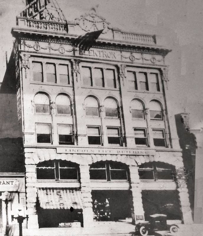
Designed by Fort Wayne architects John Wing and Marshall Mahurin, the Elektron Building was built in 1895. The name Elektron inscribed on the cornice at the top of the building reflected the business interests in early electrical engineering of the . . . — — Map (db m162797) HM
On West Washington Boulevard just west of Fairfield Avenue, on the left when traveling west.
9 January 1865. Patrick H. Keegan sold this half-lot to carpenter James C. Dillon who built a frame, one, and one-half story house.
28 June 1889. His three daughters sold this house to Patrick H. Keegan.
21 April 1914. Mr. . . . — — Map (db m197188) HM
On W. Washington Boulevard, on the right when traveling east.
Fire Station #3
226 W. Washington Blvd
has been placed on the
National Register
of Historic Places
by the United States
Department of the Interior
c. 1893 — — Map (db m197147) HM
On W. Washington Boulevard, on the right when traveling east.
Fort Wayne
Printing Building
c. 1911
has been placed on the
National Register
of Historic Places
by the United States
Department of the Interior — — Map (db m197146) HM
On S. Calhoun Street at W. Washington Boulevard, on the right when traveling south on S. Calhoun Street.
Schmitz Block
c. 1888
has been placed on the
National Register
of Historic Places
by the United States
Department of the Interior — — Map (db m197145) HM
On South Calhoun Street at East Main Street, on the right when traveling north on South Calhoun Street.
The present Allen County Courthouse is the fourth to serve the county's judicial needs. Its cornerstone was laid on November 17, 1897, in the largest public ceremony held in Fort Wayne to that time. Louis Peltier, who had been born in the fort in . . . — — Map (db m162792) HM
On West Main Street west of Webster Street, on the right when traveling east.
The Edsall House, the oldest structure in downtown Fort Wayne and the city's second hospital, was built by William S. Edsall in 1839. Edsall was a fur trader, builder, ferry operator, surveyor, sawyer and merchant, and was prominent in Fort Wayne . . . — — Map (db m215660) HM
On West Main Street west of Webster Street, on the right when traveling east.
Edsall (1811-1876) was an early community leader, serving on the first City Council, and later was a land office register and County Clerk. He was also a fur trader, merchant, plank road and railroad builder in the Fort Wayne area and helped Fort . . . — — Map (db m215666) HM
On South Van Buren Street (Indiana Route 135) just south of West Main Street, on the right when traveling south.
Frank P. Taggart Building / Miller’s Drug Store, circa 1873, has been entered in the National Register of Historic Places by the United States Department of Interior. — — Map (db m206745) HM
On East Main Street at South Van Buren Street (Indiana Route 135) on East Main Street.
Ever since the year 1867, a public hostelry of one form or another has occupied this corner. It served the logging industry for many years & later became a gathering place for artists. In recent years it has become the cornerstone of the tourist . . . — — Map (db m206747) HM
On Elm Street south of East Williams Street, on the right when traveling south.
1817 – Samual Vance sells lots 165, 166, 179, and 180 to Dr. Ezra Ferris for $200.
1818 – Judge Isaac Dunn pays $500 for lots 165, S. ½ of 179 and 180.
1848 – House built, No. 19 Elm Row, possibly a rental.
1868 – Dunn sells to . . . — — Map (db m222780) HM
On Short Street south of East Williams Street, on the left when traveling south.
The Lawrenceburg Volunteer Fire
Department was established in 1882.
Company No. 1 was located
here on Short Street, and Company
No. 2 was near Shipping Street. Both
firehouses were identical Queen Anne
style buildings built c.1882. . . . — — Map (db m222799) HM
On West Charles Street west of South Walnut Street, on the right when traveling east.
This building was listed in the National Register of Historic Places as a contributing structure to the Walnut Street Historic District in 1989. It was designated as a local landmark by Muncie City Council in 1990. — — Map (db m222318) HM
On North Geiger Street just north of Market Street, on the right when traveling north.
has been placed on the National Register of Historic Places by the United States Department of the Interior May 12, 1975 Henry Mursinna, Architect — — Map (db m171498) HM
On North Newton Street (U.S. 231) just north of West Schuetter Road, on the left when traveling north.
Increased crime during the Great Depression demanded an expanded police presence and faster communication technology. In response, the Motor Vehicle Police (established in 1921) was reorganized as the Indiana State Police in 1933. The new division . . . — — Map (db m238483) HM
Near W. Beardsley Avenue at N. Main Street, on the right when traveling west.
The Havilah Beardsley
House
102 West Beardsley Avenue
has been placed on the
National Register
of Historic Places
by the United States
Department of the Interior
1848 — — Map (db m76261) HM
On East Main Street (Indiana Route 111) at East 7th Street, on the right when traveling east on East Main Street.
[side 1] William S. Culbertson, wealthy merchant, opened home November 18, 1873 to provide food, clothing, and shelter for town's destitute widows. Home had gas lighting, upstairs water closet, and up-to-date kitchen. Residents' lives were . . . — — Map (db m180503) HM
On East Main Street (Indiana Route 111) close to Bank Street, on the right when traveling west.
Built in 1837 this building housed New Albany’s First Bank — a branch of the State Bank of Indiana. Of Greek Revival style, it was built of native limestone quarried from the hills of Floyd County. — — Map (db m193690) HM
On East Main Street, on the right when traveling west.
Milford Home
has been placed on the
National Register
of Historic Places
by the United States
Department of the Interior
Built 1845 — — Map (db m9310) HM
On North Hart Street just south of West State Street, on the right when traveling south.
The site of the town of Princeton was chosen as the county seat in 1814 by county commissioners William Prince, Robert Elliott, Abel Westfall, and William Polk. On February 14, 1814, the name Princeton was chosen by the commissioners, casting lots . . . — — Map (db m190739) HM
On North Main Street just north of West 2nd Street, on the left when traveling north.
Baldwin Addition Historic District
has been placed on the
National Register
of Historic Places
by the United States Department of the Interior
Built 1858
Calvin Dillon House — — Map (db m182737) HM
On North Main Street just north of West 2nd Street, on the left when traveling north.
Baldwin Addition Historic District
has been placed on the
National Register
of Historic Places
by the United States
Department of the Interior
Circa 1880
Built By: Enoch Beals — — Map (db m182739) HM
On North Main Street just south of East 3rd Street, on the right when traveling north.
Baldwin Addition Historic District
has been placed on the
National Register
of Historic Places
by the United States
Department of the Interior
Built C.1892
Frank Ziegler House — — Map (db m182738) HM
On North Main Street at West 4th Street, on the right when traveling south on North Main Street.
Baldwin Addition Historic District
has been placed on the
National Register
of Historic Places
by the United States Department of the Interior
Built 1903
John H. Wilson
— — Map (db m182708) HM
On North Main Street north of East 3rd Street, on the right when traveling north.
Baldwin Addition Historic District
has been placed on the
National Register
of Historic Places
by the United States
Department of the Interior
C: 1890
Built By M.J. Millspaugh — — Map (db m182741) HM
Near Allisonville Road, 0.6 miles north of East 126th Street.
This was a home where children were born and neighbors came to call.
Travelers stopped here for a warm bed and a generous table. They played music and talked about books and ideas and the wider world beyond the river.
Judges held court . . . — — Map (db m233143) HM
On North Elm Street north of East Beaver Street, on the right when traveling north.
Site of the first Methodist church, Corydon. Lot purchased from Isaiah Boone, son of Squire Boone, in 1826. Earlier, Corydon was a station on Silver Creed Methodist Circuit. Services were held in Corydon as early as 1816. — — Map (db m9716) HM
On North Mulberry Street at East Walnut Street, on the right when traveling north on North Mulberry Street.
Built 1817. Housed offices of State Treasurer and Auditor until Fall of 1824. The cellar was the Treasury vault. Building used by Harrison County Seminary, 1829-51. Since 1871, home of Amzi Brewster heirs. — — Map (db m241644) HM
On North Capitol Avenue (State Road 62) at West Cherry Street, on the right when traveling south on North Capitol Avenue.
First Log Jail erected 1809. Spier Spencer, First Sheriff, was killed 1811 commanding the Harrison County Yellow Jackets in the Battle of Tippecanoe.
During first twelve years, Harrison County had a whipping post where justice was meted out by . . . — — Map (db m9628) HM
On North Capitol Avenue near East Cherry Street, on the right when traveling north.
The Capital of Indiana Territory was moved to Corydon from Vincennes, 1813.
This building became first State Capitol, 1816.
Offices were moved to Indianapolis in 1825. — — Map (db m9626) HM
On North Capitol Avenue south of West Beaver Street, on the left when traveling north.
Old Capital Bank & Trust Company was organized in March, 1922 and began operation at 202 N. Elm Street, across the Square.
Bank later purchased this bilding at public auction for $35,000 and opened March 31, 1923. The Neo-Classical structure, . . . — — Map (db m9717) HM
On East Main Street (U.S. 36) near North Wayne Street, on the right when traveling west.
Organized 1876 at Ladoga as second private Indiana normal school specializing in teacher training. Based on Alfred Holbrook's techniques at his normal college in Lebanon, Ohio which pioneered teacher training in America. Central Normal College was . . . — — Map (db m239) HM
On West Main Street (U.S. 36) west of Cross Street (State Road 39), on the right when traveling west.
(Side One) Residential district bounded by Main, East, Cross, and Marion streets. Nineteenth and early twentieth century homes reflect social and economic diversity of residents, including town’s prominent citizens. Listed in National Register of . . . — — Map (db m237) HM
On Hobard Drive, 0.1 miles north of Rebecca Street, on the right when traveling north.
Never receiving a formal name, IU Kokomo Main has always been
identified as the “main” building, distinguished for being the first building
on this campus. Opened in 1965, this comprehensive structure
represented a new Kokomo campus relocating . . . — — Map (db m231194) HM
On East Park Drive (U.S. 224) at Warren on East Park Drive.
The first permanent hotel of Huntington was built of stone on this site by General John Tipton in 1835. Standing on the bank of the Wabash and Erie Canal, it was a commercial, political and social center. From 1862 to 1872 it housed one of the first . . . — — Map (db m7547) HM
On West Clark Street, on the right when traveling east.
Outhouse built by WPA during Depression costing buyer $5.00. Commonly called "Roosevelt Privies." Donated by Edward Kosta Jr. Family to Fair Grounds in 2013 — — Map (db m240749) HM
On West Clark Street, on the right when traveling east.
Built ca. 1870 in Barkley Township by Mark Quick. In 1901, Thomas Walters bought the farm. The cabin had four additional rooms which were later separated and the cabin was used as a lambing shed. In 1929, Paul J. Hall, Sr., bought the farm. The . . . — — Map (db m240746) HM
On West 3rd Street, 0.1 miles east of Poplar Street, on the left when traveling east.
Volunteer Dep’t. Organized Jan. 22, 1846 Edifice built in 1848 by city of Madison — it is the oldest firehouse still in use in Indiana — — Map (db m181201) HM
On Madison Avenue north of West Broadway Street, on the left when traveling north.
The Community House was erected as a memorial to James T. And Laura Polk by their son and daughter, Ralph Polk and Pearl Polk Dungan. It was dedicated as the center for many varied activities on Feb. 5, 1920. The building has contained the public . . . — — Map (db m69310) HM
On North 2nd Street north of Busseron Street, on the left when traveling north.
The second State Bank, chartered in 1834,
was a successful and stable venture in
uncertain times. John Ewing of Vincennes
was a leader in its creation.
This branch was built by John Moore
by 1838, saved by the Francis Vigo Chapter,
DAR, . . . — — Map (db m23282) HM
The Old Courthouse has been, since its erection in 1878, a landmark in Lake County, Indiana. Construction of the central portion, including the clock tower, began with 500,000 hand-kilned bricks from the Henry Wise Brickyard in Crown Point, . . . — — Map (db m27806) HM
On West 15th Avenue at Madison Street, on the right when traveling west on West 15th Avenue.
Froebel opened here, 1912, as many European immigrants and southern blacks moved to Gary for jobs in steel mills. An experiment in progressive education, it served students of diverse backgrounds and the local community. Despite early status as . . . — — Map (db m200372) HM
On Washington Street at W. 7th Street, on the right when traveling south on Washington Street.
Given to the people of Michigan City as a cultural and civic center by Mrs. Catherine Barker Hickox in 1968. The original house was built on this site (circa) 1858 by John Barker Sr. (1814-1878). It was reconstructed in 1901 by John H. Barker . . . — — Map (db m77403) HM
On I Street north of Parkview Drive (U.S. 50), on the right when traveling north.
Courthouse square, part of original 1825 plat, surrounded by nineteenth and early twentieth century commercial buildings in various architectural styles. Limestone facing quarried and milled by local industry. Listed in National Register of Historic . . . — — Map (db m48967) HM
On 23rd Street west of P Street, on the right when traveling west.
(Side One)
Lawrence County Hospital Association was organized July 15, 1903 to build, maintain, and manage a hospital in Bedford. Opened first building 1904. State, district, and local Works Progress Administration officials and city and . . . — — Map (db m74128) HM
Near Tunnelton Road, 0.1 miles south of Parkview Drive (16th Street) (U.S. 50).
Built 1865-7 by Wm. Ragsdale. Cost $25,000. Occupied by his family 11 years. Bought 1878 by Nathan Hall, pioneer quarryman. Occupied by his family 21 years. Bought and run as a dairy farm 1899 by Alvin Tobe Hert who named the estate Pine Hall. Owned . . . — — Map (db m74154) HM
On West Grissom Avenue west of South 7th Street, on the right when traveling west.
Mercury 4 Virgil I. Grissom Liberty Bell 7 Gemini 3 Virgil I. Grissom • John W. Young The Molly Brown Apollo 1 Virgil I. Grissom • Ed White • Roger B. Chaffee — — Map (db m195330) HM
The home is located on Lot 3 of the original plat presented by President Monroe in 1823 as Andersontown by William Conner, son-in-law of Chief Kikthawenund (Chief Anderson). Here Captain John Berry built a log cabin. In 1865 Alfred Makepeace erected . . . — — Map (db m233) HM
Near Mounds Rd (State Road 232) 0.4 miles south of Markleville Rd (County Road S300E).
German immigrant Frederick Bronnenberg arrived in this area with his wife, Barbara, and several children in 1821. While traveling to Illinois, one of the oxen in their team gave out nearby. The Bronnenbergs decided to make their home here, in . . . — — Map (db m62127) HM
Near Mounds Road (State Road 232) 0.4 miles south of Markleville Road (County Road S300E), on the right when traveling south.
The Bronnenbergs represent true pioneer spirit and a preservationist ethic.
Frederick Brandenburg was born in 1775 in Germany. As a youth he apprenticed as a tanner. Brandenburg immigrated to America as a young man, changing his name to . . . — — Map (db m163062) HM
Near Lincoln Drive at Granview Drive, on the left when traveling east.
The “Old Wooden Dining Hall” was built in 1918, replacing an even older dining hall.
This new dining hall had brick ovens built behind the structure to bake fresh bread and
was used until the mid-1950s when the current Maxon Cafeteria was . . . — — Map (db m231387) HM
On East State Street at High Street, on the right when traveling east on East State Street.
Side A
Pendleton’s first Library Association was formed in 1877. Subscribers paid $5 each for one of 200 association shares.
In 1906, 18 community residents formed the Independent Social Club. Each read a book, they brought it to a meeting. . . . — — Map (db m104357) HM
Near Nortn Blackford Street north of Indianapolis Cultural Trail, on the right when traveling north.
In the early 1900s, people from around the nation and world traveled through Boone County's rich farmland to view the courthouse in Lebanon. Built with 38-foot high columns, each carved from a single block of limestone, the courthouse is situated on . . . — — Map (db m238761) HM
On East St. Clair Street west of North Pennsylvania Street, on the right when traveling west.
Listed in the National Register of Hitoric Places, August 28, 1975, by the United States Department of the Interior in cooperation with the Indiana Department of Natural Resources, Division of Historic Preservation & Archaeology. — — Map (db m132854) HM
On E. Michigan Street at Massachusetts Avenue, on the left when traveling west on E. Michigan Street.
Side one:
Built for German societies of Indianapolis including Socialer Turnverein: east wing 1893-1894, west wing 1897-1898. Designed in German Renaissance Revival Style by Indianapolis firm of Vonnegut and Bohn. Sculpted terra cotta and . . . — — Map (db m86962) HM
On West Washington Street, 0.1 miles west of Capitol Avenue, on the right when traveling west.
When Alexander Ralston and Elias Fordham laid out the original Mile Square Plan for Indianapolis, they set aside Square 53 for a “State House” two blocks west of what is now Monument Circle. In 1835 a first state house was completed on . . . — — Map (db m95384) HM
On East Street at Lockerbie Street, on the left when traveling south on East Street.
This historic neighborhood was originally platted in 1847 and 1850. Its name was derived from Lockerbie Street, which was named after George M. Lockerbie, an early Indianapolis resident. James Whitcomb Riley, who resided on Lockerbie Street . . . — — Map (db m1826) HM
On North Capital Avenue near West Market Street, on the right when traveling south.
State capital was moved to Indianapolis, 1825, from Corydon. The capital built on this site in 1835 was razed in 1878 to make way for this State House, completed in 1888. — — Map (db m63953) HM
On North Delaware Street at East 12th Street on North Delaware Street.
Vibrant historic district was home to many social, political, commercial, and industrial leaders of Indianapolis during the last half of nineteenth through early twentieth centuries. Revitalization of Old Northside is part of national historic . . . — — Map (db m4633) HM
On North Pennsylvania Street at East St. Clair Street, on the right when traveling south on North Pennsylvania Street.
American Legion Mall comprises two city blocks and is the largest of the five-city block plaza. The actual mall is located at the north end of this part of the plaza. The plaza's overall design is reflective of The National Mall in Washington, D.C. . . . — — Map (db m132857) HM
On West Washington Street at North Illinois Street on West Washington Street.
Built in 1872 for the heirs of Humphrey Griffith – the city’s first watch and clock maker – the Griffith Block stood for 128 years at 36-38 West Washington Street, the northwest corner of West Washington and Bird Streets. This commercial . . . — — Map (db m86965) HM
On Capital Street at Maple Street, on the right when traveling west on Capital Street.
Bronze Plaque
This property
is listed in the
National Register
of Historic Places
by the United States
Department of the Interior
Engraved Stone
Martin County
Court House
Erected 1876 . . . — — Map (db m47420) HM
On West Kirkwood Avenue east of South College Avenue, on the right when traveling east.
Built: 1868
Renovated: 1988 by CFC Inc.,
a Cook Group company
107
West Kirkwood Avenue
This building once housed Whetsell Shoe Store, established in 1884 by Ed Whetsell — — Map (db m232321) HM
On West Kirkwood Avenue west of Walnut Street, on the right when traveling west.
Side One
County formed by Indiana General Assembly and Bloomington selected as county seat 1818. One-story, two-room log cabin built 1818 as first courthouse and school. Second courthouse, built here 1819-1826, was two stories, brick with . . . — — Map (db m48109) HM
On North Washington Street at U.S. 231 on North Washington Street.
This jail and sheriff’s residence built 1882. First rotary jail built in U. S. constructed to plans based on patented design of William H. Brown and Benjamin F. Haugh of Indianapolis. In use until 1973. Opened as museum and restoration begun 1975. . . . — — Map (db m46566) HM
On South Washington Street at West Wabash Avenue, on the right on South Washington Street.
In 1824, Presbyterians worshipped together for the first time in Montgomery County in an unfinished log cabin. Expressing their religious mission through education, Presbyterians founded Wabash College in 1832 and the county's first free preschool . . . — — Map (db m9126) HM
Noble County formed by General Assembly 1836, named after James Noble first US Senator from Indiana. County seats Sparta 1836, Augusta, 1837, Port Mitchell 1844. Center later named Albion selected 1846 as county seat in runoff election. Arrival of . . . — — Map (db m3387) HM
On Hartford Pike at Old State Road 56, on the right when traveling north on Hartford Pike.
Who would think that a country road would hold so much history? Old State Highway 56 takes you past the historic Speakman-Tallentire house and to a famous bridge.
Elderly Stephen S. Speakman was in love with a young Kentucky belle who agreed . . . — — Map (db m66899) HM
On Main Street (State Road 262) at South Mulberry Street, on the right when traveling east on Main Street.
Indiana’s oldest in continuous use. In its northeast corner was deposited the first court house cornerstone in the State laid with Masonic ceremonies. Traditional rites were held July 4, 1844, Colonel Abel C. Pepper, P.G.M., officiating. — — Map (db m45996) HM
On South Front Street south of Main Street, on the right when traveling south.
Built in 1817 by steamboat captain and boat owner Daniel Brown. This building has a long and interesting history. Rumors and suspicions abounded that Captain Brown counterfeited United States Bank notes. While in New Orleans he was arrested and . . . — — Map (db m222418) HM
On Court Street (North Side) at North Gospel Street (State Road 37), on the left when traveling west on Court Street (North Side).
The Orange County Courthouse
circa 1850 has been placed on the National Register of Historic Places
by the United States Department of The Interior
1975 — — Map (db m47451) HM
On West Baden Avenue just west of Broadway Street (Indiana Route 56), on the right when traveling west.
Built 1917 • Restored 1987 Board of Directors Mr. Arnold F. Habig, Chairman Mr. Everett Land, President Mr. Thomas L. Habig, Secretary Miss Harriett Brown Mr. John B. Habig Mr. Ronald J. Sermersheim Mr. James M. Tucker Mr. Douglas A. . . . — — Map (db m195100) HM
On East Market St at South Main Street on East Market St.
Owen County formed by General Assembly, 1819. Spencer selected county seat, 1820. Neoclassical building designed by Jesse T. Johnson, Indianapolis and built by Christian Kanzler & Son, Evansville (1910-1911),was second courthouse on land donated by . . . — — Map (db m5088) HM
151 entries matched your criteria. The first 100 are listed above. The final 51 ⊳