Near Tower Hill at Trinity Square, on the left when traveling west.
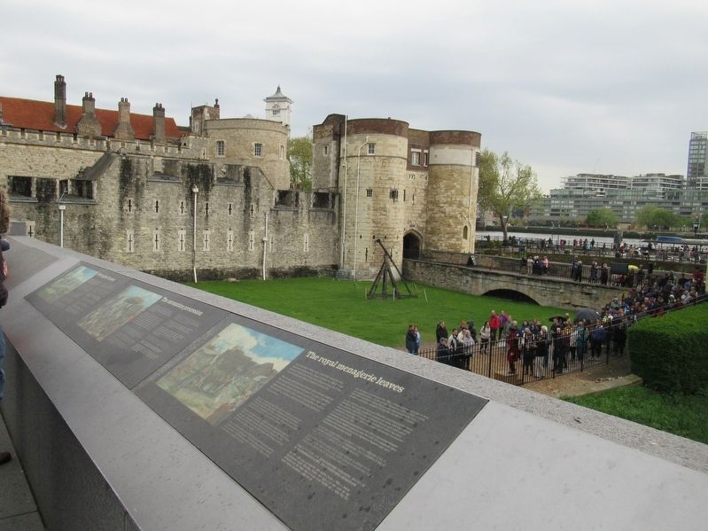
Since the reign of King John (1199-1216) monarchs had kept exotic beasts at the Tower. However, by 1831-2 it had become impractical to keep the menagerie here and it was moved to Regent's Park to establish London Zoo.
The animals were gifts . . . — — Map (db m117332) HM
Near Tower Hill at Trinity Square, on the left when traveling west.
By the 18th century the view of the castle was very different. Towers were heightened with brick, and gun platforms were added, bristling with cannon. Rooftops of houses, storehouses and workshops peeped over the outer walls.
The Tower was . . . — — Map (db m117325) HM
Near Tower Hill at Trinity Square, on the left when traveling west.
The Tower in flames
In the early hours of 31 October 1841, the Grand Storehouse caught fire and burned to the ground. Crowds watched the flames destroy the huge 17th-century building and artists painted the spectacle.
The fire began in a gun . . . — — Map (db m128432) HM
Near Tower Hill at Trinity Square, on the left when traveling west.
William the Conqueror began the Tower of London close to the riverside, to stop invaders coming up the Thames. The foreshore was originally an open beach, but as London developed, wharves and warehouses were built to serve its growing trading . . . — — Map (db m117356) HM
Near Tower Hill at Trinity Square, on the left when traveling west.
This wharf was built in the 13th and 14th centuries to allow ships to dock next to the fortress. Where you are standing now would have been busy and bustling with people loading and unloading ships with weapons and military supplies. From the . . . — — Map (db m117359) HM
Near Tower Hill close to Trinity Square, on the left when traveling west.
On 15 June 1845, the Duke of Wellington, hero of the Battle of Waterloo and Constable of the Tower, laid the foundation stone of these barracks, named after his greatest victory. Built to house up to 1,000 soldiers, the barracks were designed by . . . — — Map (db m117659) HM
On Tower Hill at Trinity Square, on the left when traveling west on Tower Hill.
The Roman invaders under Emperor Claudius founded London and later built a wall around the city. This is the site of one of the turrets, a small tower that marked a change in the direction of the wall. The Romans later replaced the turret with a . . . — — Map (db m117656) HM
Near Tower Hill at Trinity Square, on the left when traveling west.
William the Conqueror began building his great keep, known as the White Tower in the 1070s, and it was probably finished by his sons. They built the White Tower on this spot to frighten invaders arriving from the river and to intimidate the . . . — — Map (db m117655) HM
To Commemorate the tragic history and in many cases the martyrdom of those who for the sake of their faith country or ideals staked their lives and lost. On this site more than 125 were put to death. The names of some of whom are recorded here. . . . — — Map (db m78678) HM
Near Tower Hill at Trinity Square, on the left when traveling west.
From here you can see surviving parts of the 13th-century main entrance to the Tower. Built for Edward I by 1281, the Middle Tower and Byward Tower were linked by a drawbridge and causeway spanning a water-filled moat. The area below you is now . . . — — Map (db m117360) HM
Near Tower Hill at Trinity Square, on the left when traveling west.
There has been a cottage on this site for at least 200 years. Originally, it was the home of the Controller of the Tower Wharf, known as the Wharfinger.
Until the late 19th century, the Wharf was a busy dockside. Weapons, gunpowder and other . . . — — Map (db m117355) HM
Near Tower Hill at Trinity Square, on the left when traveling west.
The skeletons of two boys were found hidden under this staircase, when a building protecting the entrance to the White Tower was demolished in 1674. Many people, including Charles II believed that they were the remains of two who disappeared in . . . — — Map (db m117657) HM
During the reign of King Stephen, there was a civil war - both Stephen and the Empress Matilda were claiming the English throne. As Stephen's brother and advisor, Bishop Henry was close to the centre of these affairs.
In 1141, King Stephen . . . — — Map (db m246539) HM
The surviving ruins of Wolvesey were largely the creation of one man, Bishop Henry of Blois (1129-71), who built a palace befitting his immense wealth and powerful position.
When Henry of Blois became bishop of Winchester in 1129,
the . . . — — Map (db m246448) HM
On College Street, on the left when traveling east.
You are standing at the entrance to one of the greatest medieval buildings in England - the palace of the powerful and wealthy bishops of Winchester.
Throughout the medieval period the bishops of Winchester held one of the highest positions . . . — — Map (db m246446) HM
On St Peter’s Place at Pound Lane, on the right when traveling north on St Peter’s Place.
Westgate
The Westgate, built in c. 1380 on the site of a Roman gate, is one of the finest surviving medieval gateways in Britain and one of the first major fortifications to incorporate facilities for guns. Though built as a fortification against . . . — — Map (db m129527) HM
On Victoria Road (England Route A258) at Deal Castle Road, on the right when traveling north on Victoria Road.
Historic Deal
Deal Castle
Historic Deal
In 1539-1540 King Henry VIII carried out an enormous programme of defensive building round the eastern and southern coasts of England. Having renounced catholicism, he was expecting invasion from his . . . — — Map (db m128669) HM
Near Castle Hill Road close to Canons Gate Road, on the left when traveling south.
St Mary-in-Castro church was built around AD 1000, before the Norman Conquest.
The pharos is a Roman lighthouse and the oldest building in the castle.
The Duke of Suffolk’s Lodgings, a castle building modified for the Duke of Buckingham in . . . — — Map (db m128503) HM
Near Castle Hill Road at Canons Gate Road, on the left when traveling south.
Dover's defences
A mighty fortress
There was a castle here shortly after the time of the Norman Conquest in 1066. The medieval defences visible today were built in three periods between 1179 and 1256. They evolved over the next 700 years, . . . — — Map (db m128505) HM
Near Castle Hill Road close to Canons Gate Road, on the left when traveling south.
Dover’s early history
Long before the castle
People occupied this hill over 2,000 years ago and as much as 1,200 years before Dover Castle was first built. the huge earthworks of the castle outer bailey probably began as the ramparts of an . . . — — Map (db m128500) HM
Near Castle Hill Road at Canons Gate Road, on the left when traveling south.
Medieval Dover
The heart of the medieval castle
The inner bailey of the castle was built for King Henry II by his engineer, Maurice, largely between 1179 and 1199. It contained the Great Tower, which formed the ceremonial, defensive and . . . — — Map (db m128504) HM
Near Castle Hill Road at Canons Gate Road, on the left when traveling south.
Saluting Platform
Beneath here is the Long Gun Magazine,
a gunpowder magazine of c1800. This was
buried in the 1930s to form this
parade ground and saluting platform. — — Map (db m128562) HM
Near Ashford Road at Route B2163, on the right when traveling east.
Aragon the Dragon
This Cedar Tree was planted over 200 years ago and once stood 23 metres tall. Examinations of the tree revealed it was suffering from severe decay and with its decline accelerating, it caused a risk to public safety. The decision . . . — — Map (db m128466) HM
Near Ashford Road at Route B2163, on the right when traveling east.
Leeds Castle
Leeds Castle gets its name from the ancient Saxon manor of Esledes recorded on this site in the Domesday Book of 1086. Following the Norman Conquest of 1066, many manors in Kent were fortified to remind the local people and any . . . — — Map (db m128467) HM
Near Ashford Road at Route B2163, on the right when traveling east.
The castle was built on two islands in the middle of a man-made moat, which was created by Edward I in the 13th century by diverting the river Len.
The surrounding estates were farmed to supply food for the castle's tenants and the needs of . . . — — Map (db m128470) HM
Near Ashford Road at Route B2163, on the right when traveling east.
New Castle
Built in 1822 by the Wykeham Martin family on the site of an earlier building.
Bridge Corridors
Replaced in the form you see today in the 19th century.
Clock Tower
15th century
Keep or ‘Gloriette’
13th century with . . . — — Map (db m128471) HM
Near Ashford Road at England Route B2163, on the right when traveling east.
Main Castle Island
The central tower of the Gatehouse built in 1278 and through which you have just passed served as a look-out point for the garrison soldiers responsible for defending the castle.
The management of the castle was left in . . . — — Map (db m128469) HM
On Oxford Street close to Vaughan Way, on the left when traveling north.
Richard III’s Medieval Leicester
Newarke Gateway
The Newarke Gateway and the Richard III Story
After his defeat at the Battle of Bosworth, King Richard III’s corpse was brought back to Leicester and put on public display in the Newarke . . . — — Map (db m125065) HM
On The Peth (England Route B6341) at Bailiffgate, on the left when traveling south on The Peth.
Castle Quarters
Alnwick Quarters
Aln, Celtic for bright river, and wick, an Anglo-Saxon settlement, point towards the possible origins of Alnwick. From the Normans to the Tudors, Alnwick, with its mighty castle, offered a strategic defence . . . — — Map (db m125983) HM
Near The Peth (England Route B6341) at Bailiffgate, on the left when traveling south.
Sir Henry Percy Hotspur
Harry Hotspur was born at Alnwick Castle in 1364 or 1366 and was knighted in 1377 at the time when his father was created 1st Earl of Northumberland. He was supremely powerful in combat on land and sea, though sometimes his . . . — — Map (db m125984) HM
Near Links Road at Front Street, on the right when traveling north.
Early 19th Century Iron Mortar
Fitted to a wooden gun carriage this mortar is fitted with a cascabel. This ring at the breech or back of the cannon was used to attach lifting tackle when mounting or un-mounting it from its carriage. The mortar's . . . — — Map (db m125930) HM
Near Links Road at Front Street, on the right when traveling north.
It is believed that the castle acquired these two 24 pounder cannons when Napoleon was threatening to invade England in 1798. The stylised 'N' located on the left hand side of the breech is a naval service mark. This tells us that the cannons were . . . — — Map (db m125934) HM
Near Links Road at Front Street, on the right when traveling north.
This gun was purchased for £34.1.0. with an additional 74 barrels of gunpowder & a carriage bringing the total cost to £36.14.0. On 29th March 1784 Mr Cookson arranged to transport the 32 Pounder Gun on his sloop bound for Wareham, just outside . . . — — Map (db m125936) HM
Near Links Road at Front Street, on the right when traveling north.
This bell was originally in a cap house on top of the clock tower known also as the Belle Tower! As an integral part of the mechanism it sounded out at regular intervals. It was moved to its current site here in the apse of the chapel as its . . . — — Map (db m125982) HM
Near Links Road at Front Street, on the right when traveling north.
Bamburgh Castle Coastguard Station
In 1771 The Crewe Trustees published an:
“Account of the Signals made use of at Bamburgh Castle in the County of Northumberland in case Ships or Vessels are perceived in Distress, and of the charitable . . . — — Map (db m125937) HM
Near Links Road at Front Street, on the right when traveling north.
547 Bamburgh’s Recorded History Begins
Noted in the Anglo-Saxon chronicles, Ida the flamebearer conquers Din Guayrdi, Bamburgh, making it the capital of his kingdom of Bernicia.
607 – 634 Aethelfrith the Ravening Wolf
Added . . . — — Map (db m125927) HM
Near Links Road at Front Street, on the right when traveling north.
Once home to the Kings of Northumbria, from King Ida in the mid 6 Century, through toLord Armstrong, a ‘King’ of Industry, Bamburgh Castle has dominated this coastline from wooden palisade to sandstone fortress.
The story of Bamburgh goes . . . — — Map (db m125923) HM
Near Links Road at Front Street, on the right when traveling north.
This vaulted room is the middle floor of three built into the easterly of two towers on the inner curtain wall. The tops of the towers were removed during re-modelling in the late 1800s and now form seating areas The lower room is identifiable . . . — — Map (db m125978) HM
Near Links Road at Front Street, on the right when traveling north.
Originally discovered in the 19th century and thought to be a piece of a standing cross this piece of stone was later identified as belonging to a stone chair. It is currently on display in the Archaeology Room. It has been dated to around 800AD . . . — — Map (db m125941) HM
Near Links Road at Front Street, on the right when traveling north.
History
Often confused with the pillory, stocks were only designed to hold the legs and occasionally arms, whereas the pillory held the head as well. Perhaps the most famous person placed in the stocks was Cardinal Wolsey after he got drunk at . . . — — Map (db m125939) HM
Near Links Road at Front Street, on the right when traveling north.
Dating from the late 1600s this cannon was affectionately named the Armada Gun as it was believed to have come from a Spanish Armada vessel after the fleet was driven up the North Sea Coast. It was later confirmed as a Dutch trading vessel that . . . — — Map (db m125977) HM
Near Links Road at Front Street, on the right when traveling north.
The islands before you are the Farne Islands between 15 and over 20 depending on the state of the tide.
The islands were a renowned hazard to shipping and in the 18th Century, Dr Sharp, working for the Trustees of Lord Crewe, created one of . . . — — Map (db m125925) HM
Hadrian's Wall formed the north-west frontier of the Roman empire for most of the period AD 122-410. The empire's frontiers extended over 5,000 km from the Atlantic coast of Britain through Europe, the Middle East and across North Africa to the . . . — — Map (db m85985) HM
Where National Park meets World Heritage Site
Your visit
You have come to a very special place. The landscape is full of clues to our past, but it is also important for our future.
Not just a pretty place
The inspirational landscape . . . — — Map (db m86361) HM
Near Corchester Lane, 0.8 kilometers west of Stagshaw Road, on the left when traveling west.
Corbridge Roman Site
The first Roman fort at Corbridge was built about a kilometre to the west of here. It was built as a supply base for the Roman advance into Scotland in about AD 80. Five years after the fort was abandoned, the first of a series . . . — — Map (db m125529) HM
Near Corchester Lane, 0.8 kilometers west of Stagshaw Road, on the left when traveling west.
The Courtyard Building
About AD 165 a new layout for Corbridge was planned. The earlier fort buildings were mostly demolished and a little later work began on this large courtyard building. We do not know with certainty the original function of the . . . — — Map (db m125540) HM
Near Corchester Lane, 0.8 kilometers west of Stagshaw Road, on the left when traveling west.
The Early Forts
The earliest forts at Corbridge were built largely of timber. It was not until the middle of the second Century, when the last fort was built, that extensive use was made of stone.
The remains which you can see here belong to . . . — — Map (db m125541) HM
Near Corchester Lane, 0.8 kilometers west of Stagshaw Road, on the left when traveling west.
The East Military Compound
You are now standing in the east military compound, some of which lies buried in the field behind you. The most substantial remains within the compound belong to a pair of residential houses to your left, in the . . . — — Map (db m125542) HM
Near Corchester Lane, 0.8 kilometers west of Stagshaw Road, on the left when traveling west.
The Fountain House
An aqueduct brought water into the site from the north to feed a fountain here. The water flowed through an ornamental fountain-head into a large basin surrounded with decorated stone screens and from there into the stone trough . . . — — Map (db m125539) HM
On Corchester Lane, 0.8 kilometers west of Stagshaw Road, on the left when traveling west.
The Granaries
In front of you are the remains of two large granaries. They were designed to store grain to make bread, an important part of a Roman soldier's diet.
Inside the buildings the stone floors rest on low stone walls with channels . . . — — Map (db m125538) HM
Near Corchester Lane, 0.8 kilometers west of Stagshaw Road, on the left when traveling west.
The Main Street
This was the main street of the town. It formed part of an important Roman road known as the Stanegate which ran all the way from Corbridge to Carlisle. To your left are the remains of shops, a fountain, and two granaries. On its . . . — — Map (db m125531) HM
Near Corchester Lane at Stagshaw Road, on the left when traveling west.
The Side Street
This is the side street which divides the two military compounds. Originally it joined the Stanegate (the main street), but sometime in the third or fourth centuries a wall was built which closed off the far end and also linked the . . . — — Map (db m125543) HM
Near Corchester Lane, 0.8 kilometers west of Stagshaw Road, on the left when traveling west.
The West Headquarters Building
This building is thought to have been the administrative headquarters of the west compound. It was divided internally into six rooms probably with arched openings between them. The room in the centre at the back of . . . — — Map (db m125546) HM
Near Corchester Lane, 0.8 kilometers west of Stagshaw Road, on the left when traveling west.
The West Military Compound
You are now standing in the west military compound some of which lies buried in the field behind you. To your left. opposite the main gate, is the Headquarters building. There is a small underground chamber which is . . . — — Map (db m125544) HM
On Middle Street at Market Place, on the right when traveling north on Middle Street.
Vicar’s Pele
This tower, the finest of its kind, was built about AD 1300 for a Vicar of Corbridge and was lived in as a fortified vicarage until the early seventeenth century. — — Map (db m125637) HM
Near England Route B6319, 2.9 kilometers west of North Road, on the right when traveling west.
16th Century Bastle House Ruined buildings were adapted and new ones built at Housesteads in the centuries after the Romans left, when the land around became an upland farm. In the 16th century a local family built a fortified house onto the . . . — — Map (db m126423) HM
Near England Route B6319, 4.7 kilometers west of North Road, on the right when traveling west.
A Changing Fort
During its 280-year life, many changes were made in the fort, no more so than to building XV. Over the years, it served as a workshop, a barracks, a stable, and a storehouse before a small bathhouse (balneae) was placed . . . — — Map (db m126449) HM
Near road 68, 4 kilometers north of England Route A69, on the left when traveling north.
A military community Villages like Vindolanda were a vital part of the military occupation of Hadrian's Wall, and were planned extensions of the forts themselves. They provided extra space for facilities such as shops, workshops, additional . . . — — Map (db m126419) HM
Near Route B6319, 4.7 kilometers west of North Road, on the right when traveling west.
Barracks: the Last Hundred Years at Housesteads
Archaeology has revealed radical changes to the fort beginning around AD 300. One of the most important was the reconstruction of the barracks from single long buildings into smaller individual . . . — — Map (db m126447) HM
Near road 68, 4 kilometers north of England Route A69, on the left when traveling north.
The remains of the stone buildings that you see around you are but a fraction of what was once here at Vindolanda in ancient times. Before the last stone fort was built around AD213, eight forts had preceded it. Most of the earlier forts were . . . — — Map (db m126354) HM
Near road 68, 4 kilometers England Route A69, on the left when traveling north.
Vindolanda Charitable Trust
Chesterholm Museum
In 1831, Vindolanda's first excavator, Rev. Anthony Hedley, removed the remains of the derelict Scotsholm fulling mill, and built an ornate cottage for his family, calling it Chesterholm. Designed by . . . — — Map (db m126356) HM
Near road 68, 4 kilometers north of Route A69, on the left when traveling north.
Dolichenum — Temple to Jupiter Dolichenus
fanum livi Dolicheno dedicatum
This was an extremely rare temple dedicated to the god Jupiter Dolichenus, built around AD220 inside the walls of the fort, probably by a commanding officer of . . . — — Map (db m126416) HM
Near Route B6319, 2.9 kilometers Route A69, on the right when traveling west.
Mediterranean Style in Northern Climes
All Roman forts included a large prestigious house (praetorium) for the commanding officer (praefectus), his family and servants.
The praetorium was the largest building in the fort. The design came . . . — — Map (db m126424) HM
Near road 68, 4 kilometers north of Route A69, on the left when traveling north.
North West Quadrant barracks — excavated 2009-2011
These standard Roman Army barracks were constructed in cAD213 by the 4th cohort of Gauls and remained in use until the end of the 3rd century, after which they were demolished and replaced . . . — — Map (db m126362) HM
Near road 68, 4 kilometers north of England Route A69, on the left when traveling north.
Vindolanda Charitable Trust
Roman Pottery Kiln
This fully functional replica of a Roman up-draft pottery kiln, is based on information gained from the excavation of such kilns at archaeological sites across the North of England. The body of the . . . — — Map (db m126355) HM
Near road 68, 4 kilometers north of Route A69, on the left when traveling north.
S.P.Q.R.
In Memory of the Soldiers
Who Served Rome on the
Frontier at Vindolanda.
A.D. 85 — 400
Cohorts:
I Tungrorvm
III Batavorvm
VIII Batavorvm
II Nerviorvm
III Nerviorvm
IV Gallorvm
And Detachments . . . — — Map (db m126358) HM WM
Near road 68, 4 kilometers north of Route A69, on the left when traveling north.
Severan Circular Huts
Below the NW quadrant of the fort the remains of a series of circalar huts dated to cAD208-212 have been uncovered. These huts appear to have been living accommodation for an unknown group of people during a time of . . . — — Map (db m126415) HM
Near England Route B6319, 4.7 kilometers west of North Road, on the right when traveling west.
The Comanding Officer and his House
Each commanding officer (praefectus) of the fort was a nobleman of the equestrian class (equites), who might have been in charge of the soldiers at Housesteads for as little as three years before . . . — — Map (db m126431) HM
Near England Route B6319, 4.7 kilometers west of North Road, on the right when traveling west.
The Fort and its Design
Roman soldiers began to build Housesteads around AD 124 to a design used for forts across the Roman Empire. This fort is one of the best surviving examples, anywhere.
Housesteads follows a text-book template, . . . — — Map (db m126422) HM
Near Route B6319, 2.9 kilometers west of North Road, on the right when traveling west.
The Fort Food Supply
Roman forts had granaries to store the huge quantities of food required by hundreds of soldiers. The food supply had to be safe, dry and constantly replenished.
The granary (horreum) was essential for storing foods of . . . — — Map (db m126439) HM
Near road 68, 2.5 kilometers north of England Route A69, on the left when traveling north.
Three buildings dominated a Roman military settlement and these were all placed in the middle of the fort. The principia, praetorium and the horrea formed a central range of imposing buildings which could easily have been identified and located by . . . — — Map (db m126360) HM
Near England Route B6319, 2.9 kilometers west of North Road, on the right when traveling west.
The Heart of the Fort
The headquarters building (principia) was the administrative, ceremonial and symbolic heart of the fort – where regimental organisation and the imperial state religion were focussed. The building was in the . . . — — Map (db m126450) HM
Near road 68, 4 kilometers north of England Route A69, on the left when traveling north.
The Milestone
Three hundred yards to the north of this place, at the side of the Stanegate road, stands the only Roman milestone from Britain to survive intact in its original position (although without an inscription).
This replica milestone . . . — — Map (db m126357) HM
Near Route B6319, 4.7 kilometers west of North Road, on the right when traveling west.
The North Gate
The north gate (porta principalis sinistra) is the only one of the original four which opened onto land beyond the Wall. However, the approach from the north was steep and the gate was eventually reduced to a minor . . . — — Map (db m126444) HM
Near road 68, 4 kilometers north of Route A69, on the left when traveling north.
The Severan fort
Castellum Severianum
These buildings belonged to an earlier fort, used between AD208 – 211, during the reign of the African emperor Septimius Severus. The series of long rectangular buildings now on display were . . . — — Map (db m126417) HM
Near B6319, 4.7 kilometers west of North Road, on the right when traveling west.
The Vicus
Life Outside the Fort
Soldiers and civilians mixed in the vicus, a settlement outside the fort. It was a lively community of people from many places in the Empire, engaged in trade, leisure and worship. Soldiers' sweethearts and . . . — — Map (db m126421) HM
Near road 68, 4 kilometers north of England Route A69, on the left when traveling north.
You are approaching the edge of the village (vicus), looking east towards the heart of the settlement where the vicus met the walls of the fort. Where you are standing today was the main temple precinct in the 3rd century. Temple buildings . . . — — Map (db m126345) HM
Near England Route B6319, 2.9 kilometers west of North Road, on the right when traveling west.
The Wall Arrives
In AD 122, the Emperor Hadrian's decision to build the Wall was transformed into action all along the frontier. The foundation for the Wall and a lookout tower were begun here at Housesteads, before everything changed... . . . — — Map (db m126438) HM
Near road 68, 4 kilometers north of Route A69, on the left when traveling north.
Exact Replicas of Vindolanda Inscriptions
The three great altars and the tombstones were found built Anthony Hedley at Vindolanda in the early nineteenth century, and they are now in Chesters Museum.
RIB 1685
Translation:
Sacred to the . . . — — Map (db m126359) HM
Near England Route B6319, 2.9 kilometers west of North Road, on the right when traveling west.
Where the Soldiers Lived
Most of the space within the fort was occupied by barracks where the soldiers and their officers lived.
In front of you are the wall foundations of building XIII, one of ten identical fort barracks completed under . . . — — Map (db m126446) HM
Near road 68, 4 kilometers north of Route A69, on the left when traveling north.
Workshops fabricae vel officinae
These buildings, flanking a major roadway through the village (vicus), were 3rd century industrial workshops. Excavated in 2004, they appear to have been used in the initial stages of iron production. A number of . . . — — Map (db m126344) HM
Near Castle Street at Wellfield, on the left when traveling north.
This private chapel was once the most ornate room in the keep. It had a gallery above, warmed by a fireplace, for the Earl and his family. This lower level was used by servants.
In the illustration the chaplain is saying daily prayers before . . . — — Map (db m126118) HM
Near Castle Street at Wellfield, on the left when traveling north.
This is the largest room in the keep, rising to its full height. It was used not only for state banquets but also for holding court and the reception of important visitors, who might also be invited to dine with the Earl.
The illustration . . . — — Map (db m126101) HM
Near New Road at Oxford Castle, on the left when traveling west.
Oxford Preservation Trust
Archaeology,
the Castle Ditch
and its skeletons
In 2003 excavations uncovered the Castle Ditch
part of the defences of the Norman Castle.
64 human skeletons were found buried here,
many dating from the late . . . — — Map (db m124273) HM
On New Road at Worcester Street, on the right when traveling west on New Road.
New Road was new in 1770, built by a turnpike trust as a western exit from the city centre. It sliced through the former Oxford Castle bailey (the open space within the castle walls), providing an ideal site for what became the city's principal . . . — — Map (db m124318) HM
On New Road at Oxford Castle, on the left when traveling west on New Road.
Oxford Castle dates from 1071 and stamped the authority of England's new Norman rulers on the town. It changed the layout of this area but incorporated an earlier watch-tower (c.1020) which became the tower of St George's Church.
The castle . . . — — Map (db m124308) HM
On New Road close to Oxford Castle, on the left when traveling west.
( the marker is a series of medallians set into the stone pavement )
c.700 St Frideswide founds a Monastery by the River Thames
1009 The Saxon town is attacked by the Danes
1066 The Norman Conquest
1071 Robert D’Oilly . . . — — Map (db m122338) HM
Near New Road at Oxford Castle, on the left when traveling west.
Oxford Preservation Trust
Prison
D Wing
(1790)
William Blackburn designed D Wing, the Debtors' Tower and C Wing. When the prison expanded St. George's Chapel was demolished, though the ancient Crypt
remains. Oxford Castle Unlocked . . . — — Map (db m124277) HM
Near New Road at Oxford Castle, on the left when traveling west.
Oxford Preservation Trust
Prison
Debtors’ Tower
(1790)
This Tower was built to imprison debtors who owed money. A rare triangular stone staircase leads to four floors divided into cells, some with fireplaces. Prisoners remained in prison . . . — — Map (db m124276) HM
Near New Road at Oxford Castle, on the left when traveling west.
The Motte and Bailey
Oxford Castle was built in 1071 by Robert d'Oilly who had accompanied William the Conqueror from Normandy to England in 1066. The Castie was surrounded by a moat from which material came to form both a high Mound or Motte and . . . — — Map (db m124274) HM
Near New Road at Oxford Castle, on the left when traveling west.
Oxford Preservation Trust
The Perimeter
Wall at Oxford Prison
(1790)
The wall is built close to a stream using large stones with a rubble inner core and smaller loose stones above, and later, razor wire. All this made escape underneath or . . . — — Map (db m124275) HM
Near New Road close to Oxford Castle, on the left when traveling west.
Oxford Preservation Trust
Vaulted
Well Chamber
(13th century)
The Chamber houses a 54 feet deep brick-faced well which drops to the water level below the Mound. This provided a supply of fresh water to the occupants of the Tower which once . . . — — Map (db m124520) HM
On Madeira Road at Hoe Road, on the right when traveling west on Madeira Road.
English Heritage
Plymouth Royal Citadel
A bastioned artillery fortress
Construction of the Royal Citadel, designed by King Charles II's (r. 1660-85) engineer Sir Bernard de Gomme, began in 1665 during the Second Anglo-Dutch War. Its guns . . . — — Map (db m123832) HM
Near Clarence Esplanade at Ave De Caen, on the right when traveling east.
64 Pounder, Rifled Muzzle Loading Gun
This cast iron gun, weighing 71cwt (over 3,600 kilos), was made at the Royal Gun Factory, Woolwich in 1872. It is mounted on a traversing platform. The shell's projecting copper studs engage the grooved rifling . . . — — Map (db m123393) HM
Near Clarence Esplanade at Ave De Caen, on the right when traveling east.
68-pdr Smooth-Bore Muzzle Loader Gun of 96 cwt dated 1853 mounted on a standing garrison carriage.
Guns of this type fired solid round-shot of spherical explosive shell; they were some of the largest iron guns to be cast and virtually the last . . . — — Map (db m123378) HM WM