On Granville Street near Main Street (North Carolina Highway 33), on the right when traveling east.
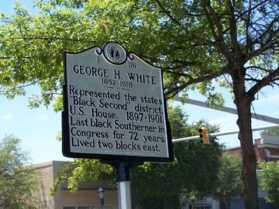
Represented the state's "Black Second" district, U.S. House, 1897-1901. Last black Southerner in Congress for 72 years.
Lived two blocks east. — — Map (db m45101) HM
On Reynolda Road (Route 67) 0.1 miles south of Donnaha Road, on the right when traveling north.
Court Houses that served old Surry County. Wright Court House Site is located one mile south. Richmond Court House Site is located one mile northeast. Andrew Jackson, seventh President of the United States, was admitted to the bar to practice law in . . . — — Map (db m98706) HM
On North Main Street at East Mountain Street, on the right when traveling north on North Main Street.
Here George Washington breakfasted June 2, 1791.
The following excerpt is from his diary of his southern tour:
"In company with the Govr. I set out for
Guilford. By 4 o'clock-breakfasted at one
Dobson's at the distance of . . . — — Map (db m98372) HM
Near Bethabara Road, on the right when traveling east.
This framework and brick home was built in 1758 for the Vorsteher (for-shtay-er), who served his community as business manager and treasurer. His duties would have been similar to those of the present-day city manager's. Due to soil erosion, the . . . — — Map (db m53453) HM
Completed in 1926, City Hall has been the seat of Winston-Salem's government since its construction. An integral part of Winston-Salem's downtown streetscape, City Hall was designed by the local architectural firm of Northup and O'Brien. City Hall . . . — — Map (db m51721) HM
Near 1st Street W west of Liberty Street, on the right when traveling west.
First Street marks the former boundary of Salem and Winston. Salem was founded in 1766 as the central congregational town for the Moravian Church in North Carolina. In 1849, when Forsyth County was formed, the Moravian Church sold 50¼ acres . . . — — Map (db m98796) HM
On N. Chestnut St., 0.1 miles north of E. 7th St., on the left when traveling north.
The congregation of Lloyd Presbyterian Church was formed in the 1870s as part of a national movement by Northern missionaries to establish African-American Presbyterian churches in the South. Lloyd Presbyterian Church's current building was . . . — — Map (db m51974) HM
On South Liberty Street at Cemetery Street, on the left on South Liberty Street.
The Salem Town Hall was Salem's last municipal building before the Town's consolidation with Winston in 1913. The last of Salem's town halls to remain standing, the building was designed by the prominent local architect Willard C. Northup and . . . — — Map (db m51720) HM
On Main Street, on the right when traveling north.
Who led the 1788 Constitutional Convention of North Carolina to decline to ratify the Federal Constitution until his State and its people were assured that a Bill of Rights would be incorporated in the United States Constitution. Perhaps more than . . . — — Map (db m63741) HM
On Second Street at North Main Street, on the left when traveling east on Second Street.
This site marks the location where Thomas J. Wilson built the first home in what would become the town of Winston. Wilson had received permission from the Moravian Church in 1847 to erect his dwelling north of Salem's central area, as he wanted to . . . — — Map (db m98780) HM
On North Bickett Boulevard (U.S. 401) at Halifax Road, on the left when traveling north on North Bickett Boulevard.
Governor, 1917-21, first in state nominated by a Democratic primary, N.C. Attorney General, member state house. Home stands ½ mi. S.W. — — Map (db m215834) HM
On This square was located the Courthouse of Gaston County from 1847 until the County seat was moved to Gastonia in 1911. The first structure, built of logs, was replaced by a brick building in 1848. The interior of this latter building, together . . . — — Map (db m18582) HM
This Greek Revival structure
served as the county courthouse
from 1848 to 1911, when the county
seat moved to Gastonia. It marks
the center of the Dallas Historic
District, a Federal Register site. — — Map (db m18577) HM
On Main Street at Williamsboro Street, on the right when traveling north on Main Street.
Granville County
Courthouse
built 1838
has been placed on the
National Register
of Historic Places
by the United States
Department of the Interior
— — Map (db m181041) HM
On Williamsboro Street just east of Belle Street, on the left when traveling west.
Erected in 1921 as the Oxford High School and later named the D.N. Hix School, this Building was renovated in 1991-1992 by the City of Oxford. The original City Hall at 120 Williamsboro Street was erected in 1908 and renovated in 1961. By agreement . . . — — Map (db m181021) HM
On West Friendly Avenue at Levi Coffin Drive, on the right when traveling west on West Friendly Avenue.
Memorial to Joseph Gurney Cannon For forty-six years congressman from Illinois Speaker, National House of Representatives, 1903-1911 who was born one and a half miles north of this place on May 7, 1836 — — Map (db m219408) HM
On West Market Street east of South Eugene Street, on the right when traveling east.
“It is obvious that to treat people equally is the right thing to do.”
“Women breathed the same air, got the same education; It was ridiculous, spending so much energy and elocution on something that was rightfully . . . — — Map (db m234032) HM
On West Market Street, 0.1 miles east of South Eugene Street, on the right when traveling east.
1879-1971. Suffrage leader &
president, Equal Suffrage Assn.
of NC, 1919-1920. Led final
meeting here 1920 to found
NC League of Women Voters. — — Map (db m234033) HM
On West February 1 Place at South Elm Street on West February 1 Place.
Henry Ell Frye, attorney, legislator, businessman and judge, has played a major role in local and state history since 1968 when he was elected to the North Carolina House of Representatives. The first African—American member of the General . . . — — Map (db m99399) HM
On North Hamilton Street south of Montlieu Avenue, on the right when traveling south.
Newspaperman and public official; ambassador to Nicaragua and Columbia; adviser to governor on racial affairs, 1963-64. Grave is ¼ mile S.E. — — Map (db m216188) HM
On West Main Street, 0.1 miles west of Parkview Terrace, on the right when traveling west.
Constructed in the period 1834-1844 by William Reece, local Constable. Stopping point on Charlotte to Goldsboro stagecoach trail. Birthplace of Joseph Reece, founder of Greensboro News and Record. Later home to J. Harper Johnston, 1881 Jamestown . . . — — Map (db m216799) HM
On Oak Ridge Road, on the right when traveling east.
Oakhurst was built for Martin Hicks Holt, Co-Principal of Oak Ridge Institute, and his wife Mary. The finest Queen Anne style house surviving in all of Guilford County, it was designed by the prominent and prolific southern architect Frank P. . . . — — Map (db m54327) HM
On Summerfield Road south of Centerfield Road, on the right when traveling south.
• Appointed by provincial Congress to purchase firearms and ammunition for troops, April, 1776.
• Member of Halifax Congress, November, 1776. On committee of accounts. Recruiting officer, 1777.
• Member of House of Commons, 1782.
• State . . . — — Map (db m234115) HM WM
On North McDaniel Street (U.S. 301) at East Franklin Street, on the right when traveling north on North McDaniel Street.
Governor of N.C., 1817-20, and of the Florida Territory, Secretary of the Navy, U.S. Senator. Home was four blocks, grave is ½ mile, west. — — Map (db m221529) HM
On King Street south of St. David Street, on the right when traveling north.
Secretary of War under Andrew Jackson; United States Senator from Tennessee; Florida governor; United States minister to Spain. Born here. — — Map (db m221553) HM
On East South Main Street (U.S. 158) at Kirkland Street, on the right when traveling east on East South Main Street.
Civil rights leader. She organized the Student Nonviolent Coordinating Committee, April 1960, at Shaw University. Her childhood home ¼ mi. E. — — Map (db m222004) HM
On NC-4, 0.5 miles north of Spruills Bridge Road, on the right when traveling north.
Champion of liberalism. Member, State Supreme Court, 1889-1924; Chief Justice, 1902-24. Editor, State Records of N.C. Home, "Airlie," was here. — — Map (db m221077) HM
On Nov. 5, 1827, Robert B. Vance, Former N.C. Congressman, was fatally wounded in a duel by Samuel P. Carson, his successor. ½ mile S.E. — — Map (db m12436) HM
On West Main Street (Business U.S. 158) west of Winder Street, on the right when traveling west.
N.C. House of Representatives, N.C. State Senate (three terms), Mayor of Murfreesboro, Chairman of School Board, Democratic Party state executive, Committee and County chairman, son of Judge David Alexander Barnes and Bettie Vaughan Barnes — — Map (db m60645) HM
On East Main Street (Business U.S. 158) east of South Wynn Street, on the right when traveling east.
Associate Justice of N.C. Supreme Court 1975-1985, Superior Court Judge-131/2 years, served in 84 counties, N.C. State Senator-four terms, Mayor of Murfreesboro and Woodland, home: 407 East High Street — — Map (db m60644) HM
On East Main Street (Business U.S. 158) at North Fourth Street, on the right when traveling west on East Main Street.
Historian, legislator, superintendent U.S. Mint at Charlotte, state treasurer, minister to Nicaragua, born 1806 in brick house 300 yds. N. — — Map (db m60639) HM
On East Main Street (Business U.S. 158) at North Fourth Street, on the right when traveling west on East Main Street.
Lawyer-banker-statesman, Member N.C. House-Senate, Corporate & Utilities Commissioner 1930-1959-Chairman 22 yrs.-lowered N.C. electric rate, equalized No./So. freight rate, born in Main St. house, Main St. home & law office moved to historic district — — Map (db m60643) HM
On South Center Street (U.S. 21) at West Sharpe Street, on the right when traveling south on South Center Street.
Dedicated to the memory of Col. Silas A. Sharpe,
a prominent industrialist and political leader in
Statesville throughout the second half of the 19th
century. He was sworn as the first Mayor of the
City of Statesville on March 25, 1867. The . . . — — Map (db m237105) HM
On West Front Street (U.S. 64) at South Mulberry Street, on the left when traveling west on West Front Street.
Now historical museum, was temporary home of Gov. Zebulon B. Vance after Sherman's capture of Raleigh. April 1865. Is 350 yards southwest. — — Map (db m51408) HM
On Great Smokey Mountain Expy (State Highway 74) at Ferguson Road on Great Smokey Mountain Expy.
Site of Daniel Bryson Sr. and Artic Virginia Dillard Brysons' home, where on March 21, 1853 the first court of Jackson County, N.C. was held, and on March 23, 1853 the county government was formed-the structure was razed in 1956 — — Map (db m12701) HM
On Henry Bird Road (U.S. 74) west of U.S. 441, on the right when traveling east.
White chief and agent of N.C. Cherokee. Secured reservation for them. Confederate colonel. State senator. Home, "Stekoih Fields", stood ¼ mi. S. — — Map (db m198004) HM
On West Market Street (Business U.S. 70) at South Front Street, on the left when traveling west on West Market Street.
Congressman, 1901-1934. Chairman House Rules Committee during parts of administrations of Wilson, F.D. Roosevelt. Grave is 200 yds. south. — — Map (db m70388) HM
On South Queen (Street State Routr 58) (Business U.S. 258) near East King Street, on the right when traveling north.
(West face)
The people of N.C. have
erected this monument
in remembrance
of the eminent services of
Richard Caswell
The first Governor under
a free constitution
(South face)
He was called to the Head
of . . . — — Map (db m68942) HM
On West Vernon Avenue (Route 70/258), on the right when traveling east.
South of this tablet, 166 yards, is the grave of Richard Caswell, the first Governor of North Carolina, as an independent state. "I will most cheerfully join any of my countrymen, even as a rank and file man, and whilst I have blood in my veins . . . — — Map (db m30488) HM
On State Highway 73 at Amity Church Road, on the right when traveling west on State Highway 73.
Governor, 1845-1849; Secretary of the Navy; United States Senator; Whig nominee for Vice President in 1852. His birthplace is 3 mi. E. — — Map (db m156518) HM
On East Church Street at North Smithwick Street, on the left when traveling east on East Church Street.
Asa Biggs (1811-1878), a prominent North Carolina politician and jurist, and his wife, Martha, built this Federal and Greek Revival—style house and lived here from 1835 to 1862. Biggs practiced law from his office just across Smithwick Street. . . . — — Map (db m152853) HM
Near West Trade Street at South Polar Street. Reported missing.
Mary Anna Morrison Jackson, Mecklenburg native and widow of Confederate General T.J. "Stonewall" Jackson, lived many years on this site. Her home was a mecca for Confederate soldiers and dignitaries including Presidents Theodore Roosevelt and . . . — — Map (db m92880) HM
Founded 1908 to promote sound civic management;
Progressive era reform. First meeting held here
attended by delegates from across the state. — — Map (db m16795) HM
On East 5th Street at North College Street, on the right when traveling east on East 5th Street.
In 1761, colonial Americans were fascinated by the royal wedding of England's King George III to a 17 year-old German princess, Charlotte Sophia of the Duchy of Mecklenburg-Strelitz. Settlers here were rebellious toward the king and his agents . . . — — Map (db m175598) HM
On South Tryon Street just south of West 4th Street, on the right when traveling south.
Built in 1924, owned by C.W. Johnston originally housed offices of prominent textile companies, a cotton exchange and the office of former Governor-U.S. Senator Cameron Morrison. Earlier on this site was the Charlotte office of J.B. Duke. — — Map (db m175621) HM
On West 5th Street just west of North Church Street, on the right when traveling west.
The first European settlers began coming to this area in the 1740's when North Carolina was a British colony. In 1762, with 777 "taxables" (adult males over twelve years of age) Mecklenburg County was created from Anson County. In an attempt by . . . — — Map (db m175529) HM
On South 3rd Street (U.S. 74) at Nun Street, on the right when traveling south on South 3rd Street.
Governor, 1836-41, the first in N.C. elected by popular vote; first president of Wilmington and Weldon Railroad. His home stands 2 blocks W. — — Map (db m28746) HM
On Market Street (Business U.S. 17) at Fourth Avenue, on the right when traveling west on Market Street.
Armed white mob met at armory here, Nov. 10, 1898. Marched six blocks and burned office of Daily Record, black-owned newspaper. Violence left untold numbers of African Americans dead. Led to overthrow of city government & installation of coup leader . . . — — Map (db m144201) HM
On South 3rd Street (U.S. 17) 0.1 miles south of Ann Street, on the right when traveling south.
United States Senator, Confederate Attorney General, Secretary of War, & of State, later lawyer in England. His early home was here. — — Map (db m28625) HM
On North 3rd Street just north of Princess Street, on the right when traveling north.
Here President William H. Taft addressed the people of Wilmington, November 9, 1909. New Hanover Historical Commission — A.J. Howell • E.S. Martin • James Sprunt • W.A. McGirt. — — Map (db m224895) HM
On Jefferson Street (State Highway 305) at Depot Street, on the right when traveling west on Jefferson Street.
Northampton County, formed in 1741, was served by other courthouses on this site prior to construction of this building in 1858. At the time Samuel Calvert oversaw the project; Henry King Burgwyn has been credited as architect. Resting atop a high . . . — — Map (db m67520) HM
On West Corbett Avenue (State Highway 24) at Front Street, on the right when traveling east on West Corbett Avenue.
Free school advocate, 1749; Southern District treasurer, 1750-1765; member of assembly for 25 years. Grave located at "The Bluff" 4 mi. N. — — Map (db m31576) HM
On West Tryon Street west of North Churton Street (Business U.S. 70), on the right when traveling west.
Site of First North Carolina Convention 1788
which refused to ratify the United States
Constitution; later ratified at Second
Convention 1789 in Fayetteville.
Placed by: Orange County Constitutional
Bicentennial Committee
July 23, . . . — — Map (db m139776) HM
On North Churton Street (Business U.S. 70) at West Tryon St, on the left when traveling north on North Churton Street.
Governor, 1845-1849; Secretary of the Navy; United States Senator; Whig nominee for Vice-President in 1852. His home stands 150 yds. W. — — Map (db m98530) HM
319 entries matched your criteria. Entries 101 through 200 are listed above. ⊲ Previous 100 — Next 100 ⊳