By Mark Hilton, December 17, 2013
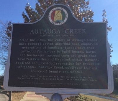
Autauga Creek Marker (reverse)
| Near West Main Street, 0.1 miles west of South Chestnut Street, on the right when traveling east. |
| On South Court Street at West Main Street, on the right when traveling south on South Court Street. |
| On Maple Street at Pletcher Street, on the right when traveling west on Maple Street. |
| On East Main Street at South Memorial Drive (U.S. 31), on the right when traveling east on East Main Street. |
| On Bridge Street at Gin Shop Hill Road, on the right when traveling west on Bridge Street. |
| On West 2nd Street east of McMillan Avenue, on the right when traveling east. |
| On County Road 49 at Swift Coles Lane, on the left when traveling south on County Road 49. |
| On Scenic Highway 98 (Alternate U.S. 98) near Zundel Road, on the right when traveling south. |
| On North Hickory Street at Municipal Park Drive, on the right when traveling south on North Hickory Street. |
| On Sibley Street, 0.1 miles west of U.S. 98, on the left when traveling west. |
| On Orange Beach Boulevard (Alabama Route 161) at John M Snook Drive, on the right when traveling south on Orange Beach Boulevard. |
| On Perdido Beach Boulevard (Alabama Route 182) 0.1 miles east of Tannin Boulevard, on the right when traveling east. |
| On Danner Circle west of Confederate Drive, in the median. |
| On Alabama Route 225, 1.2 miles north of Interstate 65, on the right when traveling north. |
| On County Road 32 at State Route 59, on the right when traveling west on County Road 32. |
| On Alabama Route 10, 0.3 miles west of County Road 41, on the right when traveling west. |
| On North Midway Street, on the right when traveling north. |
| On Blue Springs Street, on the right when traveling west. |
| On Riverside Drive at Front Street, on the right when traveling north on Riverside Drive. |
| Near East Broad Street east of North Livingston Avenue. |
| On South Eufaula Avenue (U.S. 431) near West Barbour Street, on the right when traveling south. |
| On West Barbour Street, on the left when traveling west. |
| On North Eufaula Avenue (U.S. 431) 0.1 miles north of Broad Street, in the median. |
| On East Broad Street east of North Livingston Avenue, in the median. |
| On Furnace Road (County Road 62) south of Montevallo Road (State Route 25). |
| On Montevallo Road (State Highway 25) at County Road 62, on the left when traveling west on Montevallo Road. |
| Near State Park Road south of Furnace Road (County Route 62), on the right when traveling south. |
| On State Park Road south of Furnace Road (County Road 62), on the left when traveling south. |
| On Cahaba River Drive (County Road 24), on the right when traveling north. |
| On Blocton Bypass (County Road 24) 0.1 miles east of Primitive Ridge Road, on the left when traveling east. |
| On Cahaba River Drive (County Road 24) at Piper Road, on the right when traveling south on Cahaba River Drive. |
| Near Blocton Bypass (County Road 24) west of Griffin Town Road, on the right when traveling west. |
| Near Blocton Bypass (County Road 24) west of Griffin Town Road, on the right when traveling west. |
| On Main Street at Walter Owens Drive, on the left when traveling east on Main Street. |
| Near Blocton Bypass (County Road 24) west of Griffin Town Road, on the right when traveling west. |
| On U.S. 31 at County Road 7, on the right when traveling north on U.S. 31. |
| On 6th Street South (U.S. 231) at Champion Road, on the right on 6th Street South. |
| On Ingram Avenue East at 2nd Street South, on the right when traveling east on Ingram Avenue East. |
| On Halso Mill Road (County Route 59) 0.1 miles south of Mt. Zion Road (County Road 65), on the left when traveling south. |
| On West Commerce Street (Alabama Route 10) at Bolling Street, on the left when traveling west on West Commerce Street. |
| On Noble Street north of East 10th Street, on the right when traveling north. |
| On Noble Street north of West 10th Street, on the left when traveling north. |
| On Gurnee Avenue north of West 10th Street, on the left when traveling north. |
| On Noble Street south of West 11th Street, on the right when traveling south. |
| On Noble Street south of West 11th Street, on the right when traveling south. |
| On Noble Street south of West 11th Street, on the right when traveling south. |
| On Noble Street south of West 11th Street, on the right when traveling south. |
| On Gurnee Avenue at West 11th Street, on the right when traveling south on Gurnee Avenue. |
| On Noble Street south of 12th Street, on the right when traveling south. |
| On Noble Street north of East 12th Street, on the right when traveling north. |
| On Noble Street north of East 12th Street, on the right when traveling north. |
| On Noble Street south of West 13th Street, on the right when traveling south. |
| On Noble Street at West 13th Street, on the right when traveling south on Noble Street. |
| On Atlanta Avenue at West 10th Street, on the right when traveling south on Atlanta Avenue. |
| On Noble Street at East 13th Street, on the right when traveling north on Noble Street. |
| On Williams Avenue at East 10th Street, on the left when traveling north on Williams Avenue. |
| On West 10th Street at Atlanta Avenue, on the right when traveling west on West 10th Street. |
| On West 15th Street at Glenaddie Avenue, on the right when traveling east on West 15th Street. |
| On West 15th Street at Glenaddie Avenue, on the right when traveling west on West 15th Street. |
| On Noble Street north of West 9th Street, on the left when traveling north. |
| On Noble Street south of West 10th Street, on the right when traveling south. |
| On Noble Street north of East 9th Street, on the right when traveling north. |
| On Noble Street south of West 10th Street, on the right when traveling south. |
| On East 10th Street west of Kirkwood Avenue, on the left when traveling east. |
| On Gurnee Avenue south of 12th Street, on the right when traveling south. |
| On West 11th Street at Noble Street, on the right when traveling east on West 11th Street. |
| On Gurnee Avenue south of 12th Street, on the right when traveling south. |
| On Quintard Avenue at East 17th Street, on the right when traveling north on Quintard Avenue. |
| On West 15th Street west of Walnut Avenue, on the right when traveling west. |
| On Pelham Road (Alabama Route 21) at 5th Street NE, on the right when traveling north on Pelham Road. |
| On Public Square West (State Highway 21) south of Clinton Street Southwest, on the left when traveling south. |
| On University Circle west of North Pelham Road (State Highway 21), on the right. |
| On A Street Southwest near H Avenue Southwest, on the right when traveling west. |
| On Pelham Road North at Clinton Street Southwest, on the left when traveling north on Pelham Road North. |
| On Janney Road, 0.1 miles east of Spring Road, on the left when traveling east. |
| On Main Street at Mc Kibbon Street, on the right when traveling north on Main Street. |
| On Main Street south of East Oak Street, on the right when traveling north. |
| On 5 Points Fredonia Road (County Road 222) east of County Road 267, on the right when traveling east. |
| On North Lanier Avenue at 1st Street, on the left when traveling north on North Lanier Avenue. Reported missing. |
| On Boulevard at Combs Street, on the right when traveling south on Boulevard. |
| On 20th Avenue (U.S. 29) 0.1 miles north of 61st Street West, on the right when traveling east. |
| On County Road 251, 0.1 miles north of County Road 714, on the left when traveling north. |
| On County Road 251, 0.1 miles north of County Road 714, on the right when traveling north. |
| On West Main Street (Business U.S. 411) at Tol Street, on the right when traveling west on West Main Street. |
| On County Road (County Route 43), on the right. |
| On Shinbone Valley Road (County Road 127) 2 miles south of Alabama/Georgia State Line when traveling south. |
| Near County Road 41 near County Road 99. |
| On County Road 15 at State Route 35, on the right when traveling north on County Road 15. |
| On County Route 48, 0.2 miles south of County Route 600, on the left when traveling south. |
| On County Route 29 at County Route 45, on the right when traveling north on County Route 29. |
| On County Route 8, 3 miles east of County Route 45, on the left when traveling east. |
| Near Mitchell Dam Road, 0.5 miles east of County Road 93. |
| On Paragon Road (County Road 16) 2 miles west of State Route 17, on the left when traveling west. |
| On U.S. 84 at River Street, on the right when traveling west on U.S. 84. |
| On Main Street Circle west of Main Street South. |
| On Commerce Street (Alabama Route 177) at Magnolia Drive, on the right when traveling west on Commerce Street. |
| On Commerce Street (Alabama Route 177) at Magnolia Drive, on the right when traveling west on Commerce Street. |
519 entries matched your criteria. The first 100 are listed above.
Next 100 ⊳