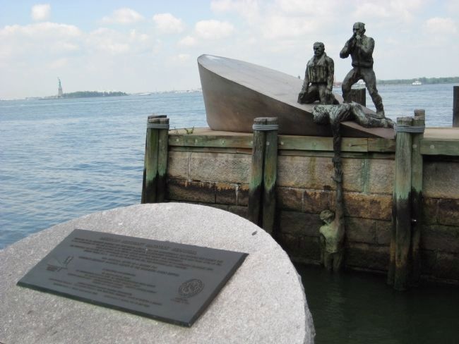
Dedicated to all Merchant Mariners who have served America from the Revolutionary War through present day. In the prosecution of war and in pursuit of peaceful commerce, unrecognized thousands have lost their lives at sea. Their sacrifices have . . . — — Map (db m29281) HM
Commissioned by the American Merchant Mariners’ Memorial, Inc., this memorial was conceived in 1976. In 1988, after an extensive competition, the artist Marisol Escobar (1930-2016), known as Marisol, was chosen to develop her design. Situated . . . — — Map (db m233775) HM
Near State Street, on the left when traveling north.
In spring 2006, during the South Ferry excavation in the Battery, four sections of a colonial era wall were identified by archaeologists. Although each of the four sections exhibited unique features, they are all likely part of the same wall, . . . — — Map (db m20306) HM
This sandstone fort was built in 1811 as one of five forts erected to defend New York Harbor. The fort originally stood on a small island that was linked to Manhattan by a 200-foot wooden causeway and drawbridge. In the 1850s, landfill extended . . . — — Map (db m147149) HM
Near Battery Place at State Street, on the right when traveling south.
[Left plaque]:
Last of a series of forts which, from the Dutch settlement of 1624, guarded lower Manhattan, this structure was built by the United States in the years 1808 to 1811. It was first called "West Battery," and was one of the . . . — — Map (db m148097) HM
Near State Street, on the left when traveling north.
Base of Memorial centerpiece, front:
1941 * * * * 1945 Erected by the United States of America in proud and grateful remembrance of her sons who gave their lives in her service and who sleep in the American coastal waters of the Atlantic . . . — — Map (db m29208) HM
Tribute to
Emma Lazarus
Poet Patriot
author of The New Colossus,
the sonnet inscribed on the Statue of Liberty
The New Colossus
Not like the brazen giant of Greek fame
with conquering limbs astride from land to land . . . — — Map (db m29387) HM
Near Battery Park Underpass just south of Battery Place, on the right when traveling south.
The site of some of New York's greatest events during the eighteenth century, the original Federal Hall was this country's first Capitol under the Constitution. On April 30, 1789 George Washington was sworn in here as the first President of the . . . — — Map (db m207510) HM
On Battery Place, 1.5 miles West Street, on the right when traveling east.
In April 1524 the Florentine-born navigator Verrazzano led the French caravel La Dauphine to the discovery of the Harbor of New York and named these shores Angouleme in honor of Francis I King of France — — Map (db m127196) HM
Near State Street south of Battery Place, on the right when traveling south.
Rising to an imposing 150 feet from a bluff overlooking the Hudson River, this monument to General Grant is the largest mausoleum in America. Constructed of over 8,000 tons of granite, the great tomb was built to honor the Civil War general who . . . — — Map (db m207520) HM
New Pier 1 was designed by General George B. Mc Clellan (of Civil War Fame), first Engineer-in-Chief of the Department of Docks. It was constructed between 1872 and 1877 as part of a larger maritime complex that included a wharf and boat landing. . . . — — Map (db m127121) HM
Near Batteru Place south of Little W Street when traveling south.
Pier A, a designated New York City landmark, was constructed by the Department of Docks' third Engineer-in-Chief, George S. Greene Jr. between 1884 and 1886.
The pier's two-story building served as the headquarters of the Department of Docks . . . — — Map (db m114673) HM
Near State Street, on the left when traveling north.
This map, dated 1695, shows a wall with batteries built to the south and west of Fort George, located at the tip of Manhattan. It was likely constructed of wood and stone. Additional works were added throughout the early to mid-18th century. The . . . — — Map (db m29319) HM
Near State Street south of Battery Place, on the right when traveling south.
When the Beatles arrived in New York City in 1964 they were met by 3,000 screaming fans. Jenny Lind, "The Swedish Nightingale", was met on the dock by 30,000 fans. But who is Jenny Lind?
Joanna Marie Lind was born in Stockholm Sweden October . . . — — Map (db m207515) HM
Near State Street, on the left when traveling north.
Order of September 18, 1814 – “The force employed will be 2 gunners and 8 matrosses (artillerists) to each gun. To every section or chamber of 2 guns a non-commissioned officer” . . . — — Map (db m20308) HM
Near State Street south of Battery Place, on the right when traveling south.
Edison's Laboratory and Home
West Orange, New Jersey
This site features Thomas A. Edison's home, laboratories, and library. Edison developed the practical phonograph and the movie camera here.
Eleanor Roosevelt's . . . — — Map (db m207517) HM
Near Battery Place near West Street. Reported permanently removed.
This monument in Battery Park north of Castle Clinton, honors military personnel who served in the Korean Conflict (1950-1953). The memorial, dedicated in 1991, was designed by Welsh-born artist Mac Adams (b. 1943) and is notable as one of the first . . . — — Map (db m33600) WM
On Battery Place south of West Street, on the right when traveling east.
This monument honors military personnel who served in the Korean War (1950-1953). The memorial, dedicated in 1991, was designed by Welsh-born artist Mac Adams (b.1943) and is notable as one of the first Korean War memorials erected in the United . . . — — Map (db m198609) HM WM
[North Marker Plaque :]
In World War II, 1,100 Norwegian ships served the Allied cause by hauling supplies between U.S. ports and the war theaters abroad. A sizeable part of the Allied forces were supplied by ships flying the Norwegian . . . — — Map (db m29309) HM
Near Battery Place near West Street, on the right when traveling east. Reported missing.
Statue of Liberty
Frederic-Auguste Bartholdi, sculptor
Alexandre Gustave Eiffel, engineer
Richard Morris Hunt, architect of base, 1871-86
Ellis Island
Boring and Tilton, architects
Ellis Island and the Statue . . . — — Map (db m132034) HM
Near State Street, on the left when traveling north.
Dedicated to the people of all nations who entered America through Castle Gardens. In memory of Samuel Rudin 1896 ---------- 1975 Whose parents arrived in America in 1883 — — Map (db m20300) HM
Near State Street, on the left when traveling north.
In 1790 the Common Council of the City of New York authorized the removal of stone and soil from Fort George and the Grand Battery to fill in the pier line along the Battery. Beginning in 1808, the defenses of the city were extended out into the . . . — — Map (db m148098) HM
Near Battery Place near Robert F. Wagner Jr. Park, on the right when traveling south. Reported permanently removed.
Left: A Floating Metropolis
A plan to create a new residential and commercial neighborhood on the site of the decaying Hudson River piers was first proposed in the early 1960s. Battery Park City is a remarkable technological achievement. To . . . — — Map (db m145913) HM
Delaware Stockbridge Munsee Tribe of Indians Band of Mohican Indians Delaware Nation Delaware Indian Burials Uncovered on Ellis and Liberty Islands Re-interred May 1, 2003 — — Map (db m49281) HM
In the decades following the War of 1812, Fort Gibson continued to be used as a military installation. Large magazines were built to store explosive black powder, which was too unstable to be kept at the Navy Yard in Brooklyn. During the Civil War, . . . — — Map (db m49335) HM
The fort that stood here on Ellis Island was part of two defensive triangles which made it almost impossible for enemy ships to approach New York City. Any ship entering the upper harbor first had to pass the guns of Fort Wood on Liberty Island and . . . — — Map (db m49310) HM
The earliest fort on this site was built in 1794. Great Britain’s navy had been seizing American merchant ships and forcing their sailors into service on British vessels. Congress decided that the nation’s most important harbors should be defended . . . — — Map (db m49336) HM
Fort Gibson was among 40 forts constructed between 1794 and 1812 in the United States. All were built during threats of war resulting from attacks on American shipping by Great Britain and France, two dominant powers of the 18th and 19th centuries. . . . — — Map (db m49311) HM
The stones you see here reveal yet another layer of the story of Ellis Island. This is the story of Fort Gibson, one of the earliest forts built after the American Revolution to protect New York Harbor. Discovered during the excavations for the . . . — — Map (db m49298) HM
If you were standing here in 1812, you would be looking at the exterior wall of Fort Gibson, which was five and a half feet thick and sixteen feet high. What you see now are the remains of that wall’s lower half. These remains, which continue seven . . . — — Map (db m49299) HM
The American Immigrant Wall of Honor ® celebrates the peopling of America. The names of individuals and families are inscribed on the wall for posterity as gifts of remembrance through donations made to restore and maintain Ellis Island. The . . . — — Map (db m49816) HM
The American Immigrant Wall of Honor ® celebrates the peopling of America. The names of individuals and families are inscribed on the wall for posterity as gifts of remembrance through donations made to restore and maintain Ellis Island. The . . . — — Map (db m49817) HM
On Broad Street, on the right when traveling south.
For more than a century, the outdoor brokers, predecessors of the American Stock Exchange, conducted a marketplace on the curbstones of the Financial District, serving investors and aiding the nation’s industrial growth. They moved indoors on June . . . — — Map (db m127678) HM
On State Street/Broadway near Battery Place, on the left when traveling south.
In “North America”, one of the four monumental sculptures called “The Continents” a Plains Indian looks over the shoulder of America.
As illustrated by the surrounding detail photographs, French acknowledged the . . . — — Map (db m146260) HM
On Whitehall Street north of Stone Street, on the left when traveling north.
Native people from many tribal nations have long come to Manhattan as visitors and workers, artists and diplomats. Many of the city’s skyscrapers were constructed with the assistance of Mohawk steel workers looking down on a city that hardly knew . . . — — Map (db m146262) HM
100 Old Slip was designed by the notable architectural firm of Hunt & Hunt in the New-Italian Renaissance style. Its visual power is created by a rhythmic series of tall arches, heavy rusticated walls and restrained ornamentation. The building's . . . — — Map (db m146133) HM
Listed on the
National Historic Register,
this building was built in 1837-1839.
In 1903 architect C.P.H. Gilbert
converted it into its current
Neo-Dutch Renaissance style.
Today the building is home to
America's oldest . . . — — Map (db m129073) HM
55’ Flag Pole donated to the City of New York by the Federation of Hellenic Societies of Greater New York on behalf of the Greek American community, in celebration of the 175th Anniversary of Greek Independence, and the 100th Anniversary of the . . . — — Map (db m47317) HM
On Broadway north of Beaver Street, on the left when traveling south.
Under construction from 1920 to 1928, the corporate headquarters for John D. Rockefeller’s Standard Oil Company was built on one of the largest parcels assembled in Manhattan at the time. The architectural firm of Carrere & Hastings, along with . . . — — Map (db m146604) HM
On Stone Street near Mill Lane, on the right when traveling west.
Listed on the NATIONAL HISTORIC REGISTER this building was completed in 1837-1839.
In 1903 architect C.P.H. Gilbert converted it into its current Neo-Dutch Renaissance style.
Today the building is home to America’s oldest security agency in . . . — — Map (db m146728) HM
On Whitehall Street near Bowling Green, on the right when traveling south.
A Place of Many Names
New York City has been known by many names among native people. It was Kanonoge, “place of reeds,” to Mohawk people living up the Hudson River. It was Menatay (island) to the Delaware people. Algonquin-speaking . . . — — Map (db m131210) HM
On Broad Street at Marketfield Street, on the left when traveling north on Broad Street. Reported permanently removed.
ADRIAEN VAN DER DONCK’S HOME Location: Marketfield Street at Broad Street Dutch Name: Het Marckvelt Steegie In a house that stood a few feet from here lived lawyer Adriaen van der Donck (c. 1620 - c. 1655), author of the . . . — — Map (db m127313) HM
On Broad Street near Beaver Street, on the right when traveling north.
Albert Sprague Bard
December 19, 1866 - March 25, 1963
25 Broad Street, originally the
Broad Exchange Building
For over 60 years, from 1901 to 1963, Albert S. Bard practiced law and pursued his civic activities from his office here. He was . . . — — Map (db m146883) HM
On Broadway at Bowling Green, on the left when traveling south on Broadway.
Before the income tax was invented, the duty levied on imported goods financed almost the entire cost of America’s federal government – and as much as 80 per cent of that duty came through the Port of New York, making the New York Custom House . . . — — Map (db m146039) HM
On State Street near Whitehall Street, on the right when traveling east.
Erected by the State of New York to honor the memory of the twenty three men women & children who landed in September 1654 and founded the first Jewish community in North America — — Map (db m127855) HM
On Broadway at Bowling Green, on the right when traveling south on Broadway.
This tablet dedicated to the memory of the men of the American Merchant Marine who gave their lives in the World War that liberty should perpetually endure. “These men rendered one of the greatest services that could have been done for our . . . — — Map (db m20289) HM
On Stone Street at Mill Lane, on the left when traveling east on Stone Street. Reported permanently removed.
ASSER LEVY’S HOME Location: Stone Street at Mill Lane Dutch Name: Hoogh Straet (High Street) In a house on this site lived the Jewish trader and butcher Asser Levy. Possibly born in Lithuania, Levy probably came here from Amsterdam in . . . — — Map (db m127960) HM
On Battery Place at State Street, on the right when traveling east on Battery Place. Reported permanently removed.
BEAVER’S PATH Location: Battery Place at Greenwich Street Dutch Name: Bever Straet Here, on a sandyshore, Lenape Indians beached their canoes to trade beaver and otter pelts for Dutch cloth, kettles, and metal tools. To the Lenape, . . . — — Map (db m127312) HM
On this site, number 6 Pearl Street, Herman Melville was born August 1, 1819. Author of Moby Dick, “Bartelby the Scrivener,” Pierre, Billy Budd and many other American classics. — — Map (db m127940) HM
Near Broadway south of Morris Street, on the left when traveling south.
The first public park to be established in New York, March 12, 1733.
“Resolved that the Corporation will Lease a Piece of Land lying at the lower End of Broadway fronting to the Fort to some of the inhabitants of the Said Broadway in Order to . . . — — Map (db m13735) HM
On Broadway at Morris Street, on the left when traveling south on Broadway. Reported permanently removed.
Bowling Green This little patch of green surrounded by grand Broadway office buildings survives as New York City’s oldest public park – Bowling Green. It served as a cattle pasture and a parade ground before being designated in 1733 as a . . . — — Map (db m147009) HM
On Bowling Green Drive at Broadway, on the left when traveling east on Bowling Green Drive.
Erected by the Common Council in 1771, this fence surrounds New York’s earliest park. The park was leased in 1733 for use as a bowling green at a rental of one peppercorn a year. Patriots, who in 1776 destroyed an equestrian statue of George III . . . — — Map (db m13728) HM
19 street panels along the path of the original Broad Street canal
1642: The Dutch create a canal south of Beaver Street by expanding a small rivulet known as “the ditch”. It is called the “Herre Graft”.
1642: Broad . . . — — Map (db m131079) HM
On Broadway near Battery Place, on the left when traveling north.
These granite panels commemorate the New York City tradition of ticker-tape parades up Broadway from the Battery to City Hall. This celebrated route is called the Canyon of Heroes. — — Map (db m183215) HM
On February 4, 1846, the ship Brooklyn sailed from Manhattan's Old Slip. Chartered by the Church of Jesus Christ of Latter-day Saints, the ship carried men, women, and children to California as part of the epic movement of Mormons to the West. By . . . — — Map (db m21511) HM
On Battery Place near Greenwich Street, on the right when traveling west.
Brooklyn-Battery Tunnel
Manhattan Plaza
Longest Underwater Vehicular Tunnel in North America
9,117 feet in length
Opened May 25th, 1950
Triborough Bridge and Tunnel Authority — — Map (db m132052) HM
What is this monument dedicated to?
The monument, depicting an interracial three-figure group in which two soldiers in fatigues bearing rifles support a wounded comrade in arms, honors those from the Coast Guard who served their country during . . . — — Map (db m198844) WM
The Cunard Line, which first opened a New York office in 1848, occupied this building on its completion in 1921. Benjamin W. Morris was the architect, and Thomas Hastings served as consultant in the design of the Great Hall, inspired by Roman and . . . — — Map (db m127334) HM
On Beaver Street at South William Street on Beaver Street.
This Renaissance Revival style building, designed by the architect James Brown Lord in 1891, is the only surviving structure associated with Delmonico's, the legendary dining establishment. Founded in 1827, it was one of the first restaurants in the . . . — — Map (db m146189) HM
On Whitehall Street near Bowling Green, on the right when traveling south.
As the years pass and native people again find traveling easier, many descendants of the first Menatay inhabitants are returning to their native land. Here they meet native people from many nations. Once, Native Americans, viewed as exotic . . . — — Map (db m131190) HM
This map, derived from a 1600 drawing, shows Stone Street, then the Dutch Hoog Straat. Its original line is indicated by brown paving stones & the lobby alignment. — — Map (db m47376) HM
On Broadway just north of Beaver Street, in the median.
On November 25, 1783 at 1:00PM, the last British Flag flying in the newly independent American states, near this site at Fort George, was removed by John Van Arsdale who climbed the flag pole which had been greased by the British, removed their . . . — — Map (db m183055) HM WM
On Broadway north of Battery Place, on the left when traveling north.
Capt. George Fried and the crew of the steamship President Roosevelt for rescuing the the crew of the British freighter Antinoe — — Map (db m209637) HM
1633 The site of the first church built on Manhattan Island Evaradus Bogardus, Dominie This tablet erected by the Daughters of Holland Dames 1933 — — Map (db m20238) HM
On Pearl Street south of Hanover Square, on the right when traveling south.
On this site William Bradford appointed Public Printer April 10th A.D. 1693 established the first printing press in the Colony of New York.
Erected by the New York Historical Society April 10th A.D. 1893 in commemoration of the 200th . . . — — Map (db m41644) HM
On Broadway at Battery Place, on the right when traveling south on Broadway.
Adjoining this site was the first Dutch fort on Manhattan Island known as Fort Amsterdam. The first house was erected here before 1664. In 1771 Captain Archibald Kennedy built here his residence which was used in 1776 by General George Washington as . . . — — Map (db m20275) HM
On State Street at Battery Place, on the left when traveling south on State Street. Reported permanently removed.
INTRODUCTION In September 1609, Henry Hudson and some 20 seamen sailed their ship, the Halve Maen (Half Moon), into what is today New York harbor. The Dutch East India Company expected Hudson to find a passage to Asia. Instead, his . . . — — Map (db m127314) HM
Near this site in 1707 Francis Makemie, a native of Ireland and Father of American Presbyterianism, challenged the edict of Lord Cornbury, Governor of the colony, forbidding him from preaching here. The services he conducted in William Jackson’s . . . — — Map (db m47313) HM
On Broad Street at Pearl Street, on the right when traveling north on Broad Street.
After the American Revolutionary War, on December 4, 1783, General George Washington bade an emotional farewell to his officers at a banquet held in the Long Room, located on the second floor of this tavern. Samuel Fraunces, a West Indian innkeeper, . . . — — Map (db m146130) HM
On Broad Street at Pearl Street, on the right when traveling north on Broad Street.
Samuel Fraunces in 1762 named his Queen’s Head tavern after Queen Charlotte, wife of King George III. His politics, however, were strictly patriotic, and his tavern hosted meetings of the radical Sons of Liberty and, later, the New York Provincial . . . — — Map (db m146131) HM
On Broad Street at Pearl Street, on the right when traveling north on Broad Street.
Erected in 1719 –. Chamber of Commerce founded here 1768. Washington’s Farewell to his Officers December 4th, 1783. Centennial Celebration of Washington’s Farewell 1883. Sons of the Revolution reorganized here December 4th, 1883. Building . . . — — Map (db m129816) HM
On Whitehall Street near Bowling Green, on the right when traveling south.
When native people of the Delaware nation speak of the place known today as Manhattan, they say Hay-La-Py-Ee-Chen Quay-Hee-OLass. This means “the place where the sun is born.” They also call it Menatay, “the island”. Their stories speak . . . — — Map (db m130939) HM
George Gustav Heye
George Gustav Heye, founder in 1916 of the Museum of the American Indian and its director until 1956, was unique in both his enthusiasm and his broad interest in native life. His passion for collecting began in 1896, when he . . . — — Map (db m131247) HM
In memory of George T. Delacorte June 20, 1893 – May 4, 1991 Publisher and Philanthropist Whose Many Gifts Beautify New York City * * * * * The restoration of this Historic Park and Fountain Is an Illustration of his Generosity Bowling Green was . . . — — Map (db m47387) HM
On South Street, on the right when traveling east.
In August 1776 island cannons were a key factor in keeping the British Navy out of the East River, allowing General Washington’s army to escape to Manhattan and fight another day. Revolutionary War Heritage Trail — — Map (db m47005) HM
On State Street at Battery Place, on the left when traveling north on State Street.
From early Dutch times the tip of Manhattan was fortified with the batteries of guns from which the Battery takes its name – first at the 17th-century Fort Amsterdam on the Custom House site, then at Castle Clinton. Fort Amsterdam disappeared . . . — — Map (db m127024) HM
On Broadway near Exchange Place, on the left when traveling south.
Cast-iron lamppost designated as a
Historic Street Lamppost
by the New York City Landmarks Preservation Commission June 1997
This is an example of the Bishop’s Crook pattern first introduced around 1900. — — Map (db m183056) HM
On State Street west of Whitehall Street, on the right when traveling west.
This chapel is built on the site of the home of Elizabeth Ann Seton. Her daughter, Rebecca was born here. The Setons lived here from 1801 – 1803. Mrs. Seton, wife, mother, educator and foundress of the Sisters of Charity, was canonized September . . . — — Map (db m209647) HM
On Broadway, on the left when traveling south. Reported permanently removed.
On November 25, 1783, at 1PM, the last British flag still flying in the newly Independent American colonies, near this site at Fort George, was removed by John Van Arsdale, who climbed the flag pole which had been greased by the British, removed . . . — — Map (db m41155) HM
Near Battery Place, on the right when traveling east.
Alberti, a native of Venice, settled near the Wall Street area of Manhattan and later in the Fort Greene section of Brooklyn.
Presented by The Italian Historical Society of America, The Columbus Citizens Foundation, The City of Venice.
The . . . — — Map (db m145884) HM
On Hanover Square at Pearl Street, on the right when traveling west on Hanover Square.
India House The handsome brownstone building facing Hanover Square, built in 1853, originally housed the Hanover Bank – making this a rare surviving bank building from pre-Civil War New York. Like so many banks, it was inspired by Italian . . . — — Map (db m19706) HM
On Broadway south of Morris Street, on the left when traveling north.
Capt. George Fried, Chief Officer Harry Manning, and the crew of the steamship America for rescuing the crew of the Italian freighter Florida — — Map (db m209630) HM
On State Street, on the right when traveling south.
This monument honors engineer John Wolfe Ambrose (1838-1899), whose vision and persistence resulted in the deep sea channel to New York Harbor, which improved the visibility of the Port of New York, making New York City the heart of commerce in the . . . — — Map (db m145669) HM
Near State Street, on the right when traveling south.
The City of New York erects this statue to the memory of a citizen whose genius has contributed to the greatness of the republic and the progress of the world. ---------- April 26, 1893. ---------- On July 31, 1803, John Ericsson was Born in . . . — — Map (db m29456) HM
Near State Street, on the right when traveling south.
This 1903 statue by Jonathan Scott Hartley (1845-1912) depicts the esteemed Swedish-American engineer and inventor John Ericsson (1803-1889), who helped to revolutionize military-maritime technology with his ironclad warship, the Monitor. Ericsson . . . — — Map (db m13850) HM
On State Street, on the right when traveling south.
Dedicated by the City of New York to John Wolfe Ambrose for whom the Deep Sea Channel is Named
His vision, scientific knowledge and indefatigable courage aided in making New York the greatest Sea Port of the World — — Map (db m107052) HM
On Broadway south of Morris Street, on the left when traveling north.
Double parade for two separate Transatlantic flights: one by Comdr. Richard E. Byrd, Lt. George O. Noville, Bernt Balchen, and Bert Acosta; and the other by Clarence D. Chamberlin and Charles A. Levine — — Map (db m209633) HM