Near Taylor Avenue (Maryland Route 435) north of Melrose Street, on the right when traveling south.
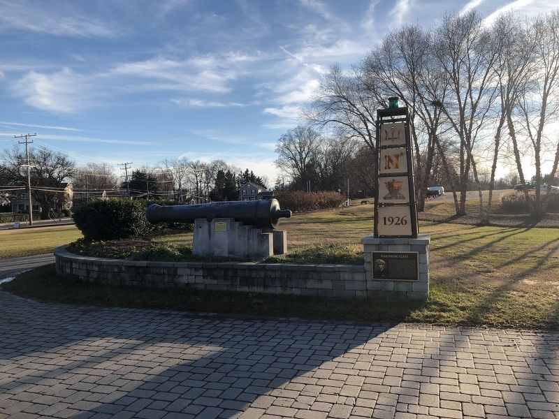
The Smedberg Gate, sponsored by the USNA Class of 1958, honors Vice Admiral William R. Smedberg, III, USN, USNA Class of 1926, who served as Superintendent of the U.S. Naval Academy from 1956 to 1958. His inspirational leadership was the catalyst . . . — — Map (db m127931) HM
On College Avenue (Maryland Route 450) at Chruch Circle (Maryland Route 450), on the left when traveling west on College Avenue.
To the memory of Rev. William Scott Southgate, for thirty years rector of Saint Anne's Parish in Anne Arundel County, Maryland. Born April 10, 1831. Died May 21, 1899.
Reverse side: Erected by the citizens of Annapolis and by his old . . . — — Map (db m9289) HM
Born: March 28, 1811
Ordained: June 25, 1836
Professed as a Redemptorist: January 16, 1842
Consecrated Bishop: March 28, 1852
Died: January 5, 1860
Canonized: June 19, 1977
— — Map (db m114536) HM
This cannon was brought from England
by the first settlers March 25, 1634
Mounted on the walls of the fort
at Old St. Mary's
Recovered from the St. Mary's River 1822
Presented to the state in 1840
by Rev. Joseph Carbery
This tablet is . . . — — Map (db m7151) HM
On State Circle at Maryland Avenue on State Circle.
1849
The Sons of Temperance buy the vacant corner lot.
1853
Temperance Hall is erected, the present two-story brick building.
1891
A grocery store and a market share the 1st floor.
The Sons of Temperance occupy the 2nd . . . — — Map (db m114554) HM
On College Avenue (Maryland Route 450) near Bladen Street.
This square is named to commemorate the 200th anniversary on December 12, 1978, of the Court of Appeals of Maryland, the state’s highest court. It encompasses Lawyers Street, shown on the earliest map of Annapolis (1718) connecting Publick Circle . . . — — Map (db m2862) HM
"There was a wharf where the steamboats came in. Right down at the foot of Prince George Street...The Tolchester boat used to come in and they'd pick up one thing or another, and bring them all up Prince George Street. Cows, horses, whatever they . . . — — Map (db m156878) HM
On Turner Joy Road, 0.3 miles east of Santee Road, on the left when traveling west.
U.S. Navy Submarines paid heavily for their success in World War II. A total of 374 officers and 3131 men are on board these 52 submarines still on "patrol."
We shall never forget that it was our submarines that held the lines . . . — — Map (db m227887) HM WM
Sy Mohr's City Dock Harbormaster Collage speaks to the magical landscape that welcomes citizens and visitors alike to the City Dock and the historical City of Annapolis. His work takes us on a trip through time, progressively moving from the past in . . . — — Map (db m114802) HM
Near Duke of Gloucester Street, on the right when traveling south.
Birthplace of Charles Carroll of Carrollton (September 19, 1737 – November 14, 1832), the only Roman Catholic to sign the Declaration of Independence and the last of the signers to die.
Charles Carroll of Annapolis (1702 – 1782), . . . — — Map (db m55298) HM
On Duke of Gloucester Street, on the right when traveling south.
Church and surrounding buildings are on land once owned by Charles Carroll of Carrollton (1737 – 1832) only Catholic to sign the Declaration of Independence and last signer to die. At rear is Carroll Manor, built c.1730, his birthplace where . . . — — Map (db m55489) HM
British vessels anchored offshore several times in 1813 and 1814, giving Annapolis good reason to expect an attack. Lookouts watched enemy maneuvers from the statehouse dome. Public records were removed from the city for safekeeping. When British . . . — — Map (db m79936) HM
On West Street (Maryland Route 450) east of Park Place, on the right when traveling west.
The first important work on water sanitation, that of Edwin Chadwick in 1842, finally seemed to have caught local attention in the 1850s when the City Council passed the first ordinances governing disposal of human remains. A decade later, large . . . — — Map (db m114561) HM
During the second half of the 18th century, shoemaker Allen Quynn owned or leased a large portion of both sides of the first block of West Street. At one time this building was Quynn's home, but in 1767 Quynn leased the house to watchmaker William . . . — — Map (db m75681) HM
On Maryland Avenue at Decatur Road, on the left when traveling east on Maryland Avenue.
was destroyed an sunk
in the Delaware River
by Col. Smith's American Battery
October 23rd, A.D. 1777
——……… ——
This Cannon is one of the sixty four. — — Map (db m100649) HM WM
On Charles Street, on the left when traveling south.
The 1718 Stoddert survey map indicates William Bladen as the first recorded owner of lot 42. Charles Carroll purchased the property in 1725 and may have been responsible for the construction of the original side hall, double parlor plan when he and . . . — — Map (db m75719) HM
On Market Space south of Fleet Street, on the right when traveling north.
The current Market House is the third to be built on this site. In 1784, Nicholas Carroll, Jacob Hurst, Charles Wallace, Joseph Williams, Thomas Harwood, John Davidson, James MacKubin and James Williams, all prominent businessmen, donated the land . . . — — Map (db m114795) HM
On Main Street at Church Circle, on the right when traveling east on Main Street.
In 1712, Philemon Lloyd of a prominent family of the Maryland Eastern Shore, had a lot surveyed for him which was to be used by the drummer of the town. The drummer, an alternative to the town crier, was unique in Maryland. His duties were to convey . . . — — Map (db m5422) HM
On West Street (Maryland Route 450) at West Washington Street, on the right when traveling west on West Street.
"This is a Community Built on Brotherhood"
Janice Hayes Williams, Historian
This intersection of West and West Washington Streets is the gateway to the "Old Fourth Ward," Annapolis' historic African American . . . — — Map (db m114537) HM
On State Circle, on the left when traveling north.
The Old Treasury Building was built by Patrick Creagh in 1735-36 for the Commissioners for Emitting Bills of Credit who issued the first paper money of the colony. Known in the colonial period as the Paper Currency Office, and the Loan Office, . . . — — Map (db m126271) HM
On State Circle at East Street, on the left when traveling north on State Circle.
The Old Treasury
The Old Treasury was built between 1735 and 1737 as the office for the Commissioners for Emitting Bills of Credit. The Commissioners were responsible for lending Maryland's newly-authorized paper currency to the colonists. . . . — — Map (db m157077) HM
On Charles Street, on the left when traveling south.
Built about 1680 The dwelling house of Mr. Jonas Green Printer to this province 1738 - 1767 Printer and publisher of the Maryland Gazette, 1745 - 1767 Flag Day, June 14, 1932 — — Map (db m75718) HM
The oldest military monument in the United States honors heroes of the War against the Barbary Coast Pirates, the new republic's first war. In 1804, President Jefferson ordered the nation's tiny naval force to the Mediterranean to protect the . . . — — Map (db m100660) HM
To the memory of Somers, Caldwell, Decatur, Wadsworth, Dorsey, Israel.
The love of Glory inspired them, Fame has crowned their deeds, History records the event. The Children of Columbia admire and Commerce laments their fall.
Erected in the . . . — — Map (db m100661) WM
On Duke of Gloucester Street, on the left when traveling south.
Erected by the Peggy Stewart Tea Part Chapter, D.A.R., Marks the building in which Gen. Washington was entertained at dinner by the Congress of the United States on the 20th of December, 1783, when he came to Annapolis to resign his commission as . . . — — Map (db m6198) HM
Near Taylor Avenue (Maryland Route 435) north of Melrose Street, on the right when traveling south.
This thirty-two pounder iron cannon barrel is a cast reproduction, circa 1905, for the USS Constitution. The Naval Historical Center, Detachment Boston, in conjunction with the National Park Service has made this cannon available to the . . . — — Map (db m127930) WM
[Inscription in dark circle on plaza deck.] Thurgood Marshall's first major victory in his life-long struggle for equality under the law for all Americans took place in the Maryland Court of Appeals which then stood near this memorial. In . . . — — Map (db m7706) HM
"...two Ferry boats were procured...we made the mouth of the Severn River but the ignorance of the People on board, with respect to the navigation of it run us aground first on Greenbury Point from whence with much exertion and difficulty we got . . . — — Map (db m19289) HM
On Calvert Street at Bladen Street (Maryland Route 70), on the left when traveling north on Calvert Street.
This brick was recovered from the west wall at the Tru Fit Clothing Company fire on February 16, 1955. Six firefighters from Baltimore City Fire Department were killed at that scene.
May they rest in peace. — — Map (db m157074) HM
On Maryland Avenue, on the left when traveling east.
Founded as the Naval School Lyceum in 1845, this is among the nation's oldest museums. It contains two full floors of exhibitions. There is extensive coverage on the War of 1812 on the first floor to the left. Inside, too, is the original signal . . . — — Map (db m63851) HM
On Cooper Road just south of Holloway Road, on the left when traveling south.
[Panel 1:]
"Be first a person of honor."
Test Pilot - First to fly Mach II in Naval Aircraft
Korea, F2H Banshee
Vietnam, F-4 Phantom
Prisoner of War, Vietnam 1967-1973
Superintendent, United States Naval Academy . . . — — Map (db m12997) HM
More than a dozen oyster houses ringed the waterfront by the 1870s, some built out into the harbor on pilings. Throughout the winter, local watermen harvested shellfish from the Bay and sold their catch to the packing houses. Shuckers, many of whom . . . — — Map (db m19291) HM
On Smithville Street just east of South Villa Avenue, on the right when traveling east.
This weeping cherry tree represents an important era in the evolution of Wiley H. Bates High School which, in the 1940s, offered many agricultural classes where crops and livestock were raised for its cafeteria and for sale to the community. The . . . — — Map (db m157078) HM
On Smithville Street, 0.1 miles east of South Villa Avenue, on the right when traveling east.
This space is dedicated to the distinguished generation of African American administrators, teachers, and students who transformed this site into the cultural center for all African Americans in Anne Arundel County. For this generation, and for you . . . — — Map (db m157083) HM
Near West Street (Maryland Route 450) at Brewer Avenue.
The record of lynchings in Maryland from 1891-1906
May 13, 1891 - Asbury Green, Centerville
May 17, 1892 - James Taylor, Chestertown
June 8, 1893 - Isaac Kemp, Princess Anne
October 20, 1894 - Stephen Williams, Prince George's County . . . — — Map (db m53171) HM
On Smithville Street, 0.1 miles east of South Villa Avenue, on the left when traveling west.
A devoted community advocate, Bates believed that education and enterprise were the keys to African American advancement. He assisted others in starting businesses, founded the Bates Kindergarten, and lobbied for the reconstruction of the Stanton . . . — — Map (db m157086) HM
On Smithville Street, 0.1 miles east of South Villa Avenue, on the left when traveling west.
Wiley H. Bates was born into slavery on a North Carolina plantation in 1859, attending only three days of schooling in his lifetime. He built a legacy based on hard work and economic success, triumphing in what he called "the race of life." . . . — — Map (db m157087) HM
Near Taylor Avenue (Maryland Route 435) north of Melrose Street, on the right when traveling south.
Alumni Arch
in honor of
Captain William S. Busik
and all
Naval Academy Alumni,
Past, Present, and Future.
"Barnacle Bill" was an All-American standout on the Navy Football team until his accelerated graduation . . . — — Map (db m127946) HM
On Taylor Avenue (Maryland Route 435) north of Melrose Street, on the left when traveling north.
[Plaque near the display:]
On the occasion of the 65th anniversary of the founding of the Navy Flight Demonstration Squadron, the Blue Angels, this aircraft display is dedicated in memory of all Blue Angels' aircrew lost in team flight . . . — — Map (db m127947) HM WM
Near Decatur Road south of Maryland Avenue when traveling east.
This plaza was presented by the Classes of 1958 and 1959 in memory of their classmates who gave their lives in the service of their country. — — Map (db m114855) WM
Near Taylor Avenue (Maryland Route 435) north of Melrose Street, on the right when traveling south.
Navy-Marine Corps Memorial Stadium has been called a "Memorial that happens to be a stadium". While visitors and athletes for nearly 50 years have been inspired by the campaigns and battles emblazoned around the stadium facade, much more needed . . . — — Map (db m127935) HM WM
On Defense Highway (Maryland Route 450) 0.6 miles west of Housley Road, on the right when traveling west.
Chartered in 1865 by the Maryland General Assembly after a fire at the State House in 1863. Waterworks began operation in 1866, designed by noted civil engineer William Rich Hutton, who had recently completed Washington Aqueduct. Innovative concrete . . . — — Map (db m51852) HM
On Forest Drive at Fairfax Road, on the right when traveling south on Forest Drive.
A man of honor…A distinguished career of professional and public service…As a Medical Doctor…As a member of the Maryland State Legislature…As an appointee of The President of the United States, to serve his Country on the National level…And as a . . . — — Map (db m5418) HM
Near West Street (Route 450) just west of Chinquapin Round Road, on the right when traveling east.
During Parole's early years, the horse and wagon was a basic means of local transportation and livelihood. Many families sold vegetables from their horse-drawn wagons.
Gardening and farming were the main occupations for Camp Parole . . . — — Map (db m232511) HM
On Solomons Island Road (Maryland Route 2) 0.2 miles south of Sommerville Road, on the right when traveling north.
Located in this vicinity, one of three camps established during the Civil War to accept paroled Union prisoners of war for Confederate prisoners similarly confined in the south. Over the course of the war, thousands of soldiers were held here until . . . — — Map (db m66303) HM
On Parole Street south of West Street (Maryland Route 450), on the right when traveling north.
Our First Church
On July 16, 1925 (at Parole, Maryland) Reverend J.J. Cecil, a retired minister of the former Washington Conference and a member of Asbury Quarterly Conference-Annapolis, conceived for a Methodist Church in Parole.
Not . . . — — Map (db m232506) HM
On Defense Highway (Maryland Route 450) at Nichols Road, on the right when traveling west on Defense Highway. Reported missing.
To Edward, Joshua, and John Dorsey, sons of Edward Dorsey who settled in Maryland in 1650. The patent was signed by Charles Calvert, then Lieutenant General, and later Third Lord Baltimore. This plantation has been the homestead of the Dorseys for . . . — — Map (db m2906) HM
On Hicks Avenue south of West Street (Maryland Route 450), on the right when traveling south. Reported unreadable.
[Unfortunately, much of the text is illegible.]
As the Church moves into a new millennium, it moves with a new vision. The current pastor, The Reverend Johnny R. Calhoun, leads this great vision for church and community growth. Plans for . . . — — Map (db m232504) HM
On Drew Street just east of Parole Street, on the left when traveling east.
"Every child has the right to be born a healthy child." This sincere belief, expressed by the principal of Parole Elementary School, Walter S. Mills, in 1936, motivated the P.T.A. of that school to begin a campaign to establish a health care . . . — — Map (db m232507) HM
On George and Marion Phelps Lane at Vincent Street, on the right when traveling north on George and Marion Phelps Lane.
The "Little Red Schoolhouse"…
…built in 1816, was the first recorded classroom for colored children in the Parole area. This one-room school was located in the general area just north of the existing intersection of West Street and . . . — — Map (db m232508) HM
Near Hicks Avenue south of West Street (Maryland Route 450), on the right when traveling south. Reported damaged.
Blacks first became eligible to vote and hold office in 1870 in the City of Annapolis. Since that time only 24 or 14% have been Black elected officials. Of those 24, only 7 have served the Parole Community in Annapolis.
The predominantly . . . — — Map (db m232498) HM
On Poplar Avenue just east of Bowie Avenue, on the right when traveling west. Reported damaged.
[Unfortunately, the marker has significantly weathered and is mostly illegible. Very little text could be interpreted:]
Renovated added new wing - 2001 — — Map (db m232741) HM
On Generals Highway (Maryland Route 178) at Defense Highway (Maryland Route 450), on the left when traveling south on Generals Highway.
Across the road stood the three mile oak under which General George Washington passed on his way to Annapolis December 19, 1783 to resign his commission as Commander in Chief of the Continental Armies. According to tradition, General Smallwood, . . . — — Map (db m76022) HM
Near West Street (Maryland Route 450) just west of Chinquapin Round Road, on the right when traveling east.
The Civil War
The Civil War had a major impact on the people of Anne Arundel County. As a border state, Maryland was home to both Confederate and Union sympathizers. Like Baltimore, Annapolis was occupied by Union troops during the Civil . . . — — Map (db m232510) HM
On West Street (Maryland Route 450) at John Hanson Highway (U.S. 50), on the right when traveling east on West Street.
Upper Plaque: This oak tree planted in 1967 perpetuates the memory of the original Three Mile Oak which stood nearby as explained in the marker below.
Lower Plaque: Trunk of the Three Mile Oak Under this tree passed General George . . . — — Map (db m2877) HM
Near Hicks Avenue south of West Street (Maryland Route 450), on the right when traveling south.
For a rich history of Ward 3, start here to visit each site with your family and friends.
1. You are here
2. Mount Olive African Methodist Episcopal Church
3. Parole Health Center
4. Cecil Memorial United Methodist Church . . . — — Map (db m232503)
Near Mansion Ridge Road, 0.1 miles east of Mansion Woods Road, on the right when traveling east.
Iglehart
1708 Mansion Ridge Road
is listed on
National Register
of Historic Places
by the United States
Department of the Interior
c. 1811
— — Map (db m142375) HM
Near College Avenue (Maryland Route 450) at Prince George Street, on the left when traveling east.
To honor the three hundredth anniversary of the coming to Maryland circa 1652 of Alexander Magruder, founder and progenitor of the Magruder family in America, and to the men of his blood who have been students at St. John's College. — — Map (db m5417) HM
This reproduction of the Liberty Bell was presented to
Maryland
by direction of
The Honorable John Snyder
Secretary of the Treasury
as the inspirational symbol of the United States savings bonds independence drive from May 15 to July 4 . . . — — Map (db m63419) HM
Near King George Street (Maryland Route 450) west of College Avenue (Maryland Route 450), on the right when traveling east.
In memory of Edmund Berkeley Iglehart Lieutenant U.S.A. Commandant of St. John's College 1907 - 1909 through whose untiring efforts this gymnasium was built — — Map (db m232483) HM
Near College Avenue (Maryland Route 450) at Prince George Street, on the right when traveling south.
Erected by the Alumni of St. John's College to their fellow Alumni who in the World War gave their all. Four hundred & fifty two of our men answered their country's call. There is no records that one failed in his duty.
The list of names:
A. . . . — — Map (db m65902) WM
Near College Avenue (Maryland Route 450) at Prince George Street, on the left when traveling east.
This tablet was fixed on McDowell Hall in 1946 to commemorate the two hundred and fiftieth anniversary of the founding of King William's School. To this hall in 1785, in the second year of the foundation of St. John's College, came the . . . — — Map (db m5423) HM
Near College Avenue (Maryland Route 450) at King George Street (Maryland Route 450).
This tablet is placed upon the Liberty Tree by the Peggy Stewart Tea Party Chapter Daughters of the American Revolution of Annapolis, Maryland, October 19, 1907 to commemorate the first treaty made here with the . . . — — Map (db m241906) HM
Near College Avenue (Maryland Route 450) south of King George Street (Maryland Route 450), on the right when traveling south.
Max and Elke Schiff were Jewish immigrants from Minsk who settled in Annapolis in 1913. Their goal in coming to America was to provide a complete education for their seven children.
These direct descendants of Max and Elke attended St. . . . — — Map (db m232488) HM
On College Avenue (Maryland Route 450) south of King George Street (Maryland Route 450), on the right when traveling south.
"Mathematics, by contemplating the uniformity, order, symmetry and calm of divine things, makes its followers lovers of this divine beauty."
Ptolemy (c. 100 CE - c. 170 CE)
Near King George Street (Maryland Route 450) 0.4 miles south of Baltimore Annapolis Boulevard (Maryland Route 450), on the right when traveling south.
This monument honors unknown French soldiers and sailors who gave their lives in the American War of Independence and were buried near here.
Dedicated by President Williams Howard Taft, April 18, 1911
"Our soldiers rest in hallowed . . . — — Map (db m9277) HM
On College Avenue at Prince George Street, on the right on College Avenue. Reported permanently removed.
St. John's College has a long, rich history dating back to the founding of our nation. Its earliest incarnation, a grammar or preparatory school named after King William III, was founded in Annapolis in 1696, one year after Maryland's capital was . . . — — Map (db m63410) HM
On King George Street (Maryland Route 450) 0.1 miles north of College Avenue (Maryland Route 450), on the left when traveling north.
The birthplace of Charles Carroll, Barrister, 1723 - 1783, colonial patriot and author of Maryland Bill of Rights. Built in 1722 by his father, Dr. Charles Carroll, Chirurgeon. Moved from its original location at Main and Conduit Streets through . . . — — Map (db m5420) HM
Near College Avenue (Maryland Route 450) at Prince George Street, on the left when traveling east.
This cannon of the type used in the defense of Baltimore in the War of 1812, presented to St. John's College, the alma mater of Francis Scott Key, through the Peggy Stewart Tea Party Chapter, D.A.R., and the National Star-Spangled . . . — — Map (db m5425) HM
179 entries matched your criteria. Entries 101 through 179 are listed above. ⊲ Previous 100