2917 entries match your criteria. Entries 201 through 300 are listed.⊲ Previous 100 — Next 100 ⊳
Notable Events Topic
By Trev Meed, November 6, 2009
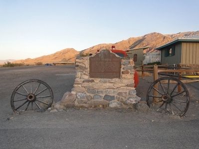
Burned Wagons Point Marker
| 201 ► California, Inyo County, Death Valley National Park, Stovepipe Wells — 441 — Burned Wagons Point — |
| On U.S. 190, on the right when traveling east. | |||
| 202 ► California, Inyo County, Trona — Fish Canyon — |
| On Slate Range Road, on the left when traveling north. | |||
| 203 ► California, Kern County, Bakersfield — Livermore and Chester Store — |
| On Chester Avenue at 19th Street, on the right when traveling west on Chester Avenue. | |||
| 204 ► California, Kern County, Lebec — 129 — Fort Tejon — |
| On Fort Tejon Road west of Interstate 5. | |||
| 205 ► California, Kern County, Lebec — Peter Lebeck — |
| Near Fort Tejon Road west of Interstate 5, on the right when traveling south. | |||
| 206 ► California, Kern County, Lost Hills — James Dean — |
| On Highway 46, on the left when traveling west. | |||
| 207 ► California, Kern County, Maricopa — 485 — Lakeview Gusher No.1 — California Historical Landmark — |
| On Petroleum Club Road, on the left when traveling north. | |||
| 208 ► California, Kern County, Taft — History of Taft — |
| Near Supply Row near East 6th Street, on the right when traveling west. | |||
| 209 ► California, Kern County, Tehachapi — The Great Flood of 1932 and Engine No. 3834 — |
| On Woodford-Tehachapi Road, on the left when traveling east. | |||
| 210 ► California, Lassen County, Susanville — Larry Griffith — |
| On Shoreline Highway near Court Street. | |||
| 211 ► California, Los Angeles County, Compton — 718 — First United States Air Meet — |
| On Wilmington Avenue north of Curtiss Street, on the right when traveling north. | |||
| 212 ► California, Los Angeles County, Glendale, Montrose — National Flag Week — "It All Started In Montrose" — |
| On Honolulu Avenue at Ocean Boulevard, on the right when traveling west on Honolulu Avenue. | |||
| 213 ► California, Los Angeles County, Los Angeles, Chinatown — Dr. Sun Yat-Sen — |
| Near Broadway north of College Street, on the left when traveling north. | |||
| 214 ► California, Los Angeles County, Los Angeles, Echo Park — Tommy Lasorda — |
| Near Vin Scully Avenue east of Stadium Way. | |||
| 215 ► California, Los Angeles County, Los Angeles, Miracle Mile — 170 — Hancock Park — La Brea Pits — |
| On Wilshire Boulevard at Curson Avenue, on the right when traveling west on Wilshire Boulevard. | |||
| 216 ► California, Los Angeles County, Los Angeles, Mission Hills — Armenian History Timeline — |
| Near Mission Hills Road, 0.2 miles west of Indian Hills Road. | |||
| 217 ► California, Los Angeles County, Los Angeles, North Hills — National Day of Remembrance — Oklahoma City Federal Building — |
| On Audie Murphy Drive just north of George S. Patton Jr Drive, on the right when traveling north. | |||
| 218 ► California, Los Angeles County, Los Angeles, San Pedro — USS Iowa (BB-61) — Turret 2 Explosion — |
| On So. Harbor Blvd. at W. 1st Street on So. Harbor Blvd.. | |||
| 219 ► California, Los Angeles County, Los Angeles, South Los Angeles — Evangelist Billy Graham's Crusade for Christ — Los Angeles Memorial Coliseum — August 15th to September 8th, 1963 — |
| Near Figueroa Street south of Exposition Boulevard, on the right when traveling south. | |||
| 220 ► California, Los Angeles County, Los Angeles, South Los Angeles — His Holiness Pope John Paul II — Unity in the Work of Service — |
| Near Figueroa Street south of Exposition Boulevard, on the right when traveling south. | |||
| 221 ► California, Los Angeles County, Los Angeles, Studio City — Republic Pictures 75th Anniversary — |
| Near Radford Avenue north of Ventura Boulevard, on the right when traveling north. | |||
| 222 ► California, Los Angeles County, Mt. Baldy Village — 514 — Pomona Water Power Plant |
| On Mt Baldy Road (at milepost 2), 3 miles north of North Mountain Avenue, on the right when traveling north. Reported missing. | |||
| 223 ► California, Los Angeles County, Pasadena, Old Pasadena — Pasadena Public Library — (1890-1927) — |
| On North Raymond Avenue south of East Walnut Street, on the right when traveling north. | |||
| 224 ► California, Los Angeles County, Pasadena, South Arroyo — Yuen Kee Laundry — |
| On Mills Place near Green Street, on the left when traveling east. | |||
| 225 ► California, Los Angeles County, Pomona, Phillips Ranch — 289 — First Home of Pomona College — |
| On White Street at Mission Boulevard, on the right when traveling south on White Street. | |||
| 226 ► California, Los Angeles County, Santa Clarita, Canyon Country — 590 — Lang Southern Pacific Station — |
| On Lang Station Road, 0.2 miles south of Soledad Canyon Road, on the right when traveling south. | |||
| 227 ► California, Los Angeles County, Santa Clarita, Newhall — Oak of the Golden Dream — |
| Near Placerita Canyon Road, 1.5 miles east of the Antelope Valley Freeway (California Route 14). | |||
| 228 ► California, Los Angeles County, Santa Clarita, Newhall — 168 — Oak of the Golden Dream — ← 2 Miles — |
| On Sierra Highway, 0.2 miles north of Placerita Canyon Road, on the right when traveling south. | |||
| 229 ► California, Los Angeles County, Signal Hill — 2 — Car Climbs on the Hill — Part of the “Memory Necklace” — A Series of Historical Panels Located in the Hilltop Loop Trail — |
| On East Panorama Drive, on the right when traveling north. | |||
| 230 ► California, Marin County, Mill Valley — United Nations Conference on International Organization — |
| Near Main Trail. | |||
| 231 ► California, Marin County, Sausalito — The Tequila Sunrise — |
| On Bridgeway north of Richardson Street, on the right when traveling north. | |||
| 232 ► California, Mono County, Lee Vining — Navy Beach — |
| On State Highway 120 at the South Tufa Area Entrance Road, on the left when traveling east on State Highway 120. | |||
| 233 ► California, Mono County, Mammoth Lakes — Tragedy at Convict Lake — |
| On Convict Lake Road west of U.S. 395, on the right when traveling west. | |||
| 234 ► California, Mono County, Topaz — Flag on Centennial Bluff — |
| On Three Flags Highway (State Highway 395 at milepost 110.5), on the right when traveling south. | |||
| 235 ► California, Monterey County, Carmel-by-the-Sea — Early American Baptisms in California — |
| Near Rio Road at Lausen Drive, on the right when traveling east. | |||
| 236 ► California, Monterey County, Jolon — First Marriage in California — |
| 237 ► California, Monterey County, Monterey — 6 — Hippolyte Bouchard Monument — When the Argentine Flag Flew Over Monterey — Cuando la bandera argentina voló sobre Monterey |
| Near Corporal Ewing Road. Reported missing. | |||
| 238 ► California, Monterey County, Monterey — Junipero Oak — |
| Near Church Streeet east of Figueroa Street, on the right when traveling east. | |||
| 239 ► California, Monterey County, Monterey — Monterey Harbor — |
| On Monterey Bay Coastal Trail. | |||
| 240 ► California, Monterey County, Monterey — Monterey History Time Line — |
| Near Pacific Street. | |||
| 241 ► California, Monterey County, Monterey — Site of Original Flagstaff — |
| Near Monterey Peninsula Recreational Trail. | |||
| 242 ► California, Monterey County, Prunedale — 651 — Battle of Natividad — |
| On San Juan Grade Road at Crazy Horse Canyon Road on San Juan Grade Road. | |||
| 243 ► California, Monterey County, Salinas — 934 — Salinas Temporary Detention Center — |
| Near North Main Street north of Bernal Drive, on the right when traveling north. | |||
| 244 ► California, Nevada County, Nevada City — Miners Foundry – Allans Machine Shop — Founded 1856 — |
| 245 ► California, Nevada County, Nevada City — 899 — The National Hotel — |
| On Broad Street, on the right when traveling east. | |||
| 246 ► California, Nevada County, North San Juan — North San Juan Fire Department — N. S. J. F. D. — |
| Near Resservoir Street south of California Highway 49, on the right when traveling south. | |||
| 247 ► California, Nevada County, Rough and Ready — Republic of Rough and Ready — April 1850 - July 1850 — |
| On Rough and Ready Highway at Mountain Rose Road, on the right when traveling west on Rough and Ready Highway. | |||
| 248 ► California, Nevada County, Rough and Ready — 294 — Rough and Ready — |
| On Rough and Ready Highway at Mountain Rose Road, on the right when traveling west on Rough and Ready Highway. | |||
| 249 ► California, Nevada County, Truckee — What Made Her Do It? — First Woman to Swim Donner Lake — |
| On South Shore Drive near Old Highway Drive. | |||
| 250 ► California, Orange County, Orange — May Festival — |
| Near Chapman Avenue at Glassell Street, in the median. | |||
| 251 ► California, Orange County, San Clemente — 562 — La Cristianita — |
| Near Avenida Granada west of Avenida Del Mar. | |||
| 252 ► California, Orange County, Tustin — Hanging Tree — |
| 253 ► California, Placer County, Auburn — Western States Endurance Run Finish Line — |
| Near Stadium Way, 0.2 miles Finley Street. | |||
| 254 ► California, Placer County, Foresthill — Old Four Fingers — |
| On Foresthill Road, on the right when traveling east. | |||
| 255 ► California, Plumas County, Blairsden-Graeagle — 723 — Pioneer Ski Area of America — |
| Near Johnsville - McCrea Road, on the left when traveling north. | |||
| 256 ► California, Riverside County, Hemet — 1009 — "Ramona" — |
| Near Ramona Bowl Road, on the right when traveling east. | |||
| 257 ► California, Riverside County, Riverside — 787 — De Anza Crossing of the Santa Ana River — California Registered Landmark No. 787 — 1775 and 1776 — |
| Near Moraga Avenue, on the right when traveling south. | |||
| 258 ► California, Riverside County, Riverside — No. 26 — Mount Rubidoux — |
| On Mount Rubidoux Drive at 9th Street, on the right when traveling south on Mount Rubidoux Drive. | |||
| 259 ► California, Riverside County, San Jacinto — 989 — Soviet Transpolar Landing Site — |
| On South San Jacinto Avenue (California Route 79) at East 6th Street, on the right when traveling south on South San Jacinto Avenue. | |||
| 260 ► California, Riverside County, San Jacinto — 43 — Transpolar Record Flight Site — |
| On Cottonwood Avenue at South Sanderson Avenue, on the right when traveling east on Cottonwood Avenue. | |||
| 261 ► California, Sacramento County, Folsom — Folsom Veterans Memorial — |
| Near Natoma Street at Stafford Street. | |||
| 262 ► California, Sacramento County, Sacramento, Midtown — 745 — The Coloma Road — |
| On L Street at 28th Street, on the right when traveling west on L Street. | |||
| 263 ► California, Sacramento County, Sacramento, Old Sacramento — Independent Boat Operations of the 1850s — |
| Near Capital Mall. | |||
| 264 ► California, Sacramento County, Sacramento, Old Sacramento — New England Seed Store — |
| On "J" Street at Commonwealth Avenue when traveling west on "J" Street. | |||
| 265 ► California, Sacramento County, Sacramento, Old Sacramento — Ten Years that Electrified Our World — |
| Near K Street at Interstate 5, on the right when traveling east. | |||
| 266 ► California, Sacramento County, Sacramento, Old Sacramento — The Early Homeless — |
| Near K Street at Interstate 5, on the right when traveling east. | |||
| 267 ► California, Sacramento County, Sacramento, Southwestern Sacramento — In Memory of the Old Tier Grounds — Of Sacramento City Cemetery — Est. 1849 — |
| 268 ► California, Sacramento County, Sacramento, Southwestern Sacramento — Luella Buckminster-Johnston — 1861 – 1958 — |
| 269 ► California, Sacramento County, Sacramento, Southwestern Sacramento — Sacramento Volunteer Fire Department — 1850 – 1872 — |
| 270 ► California, San Benito County, San Juan Bautista — El Camino Real — (The Kings Highway) — |
| 271 ► California, San Bernardino County, Chino — Site of the Battle of Chino — |
| On Eucalyptus Avenue near Pipeline Avenue, on the right when traveling west. | |||
| 272 ► California, San Bernardino County, Lucerne Valley — 737 — Chimney Rock — |
| On Old Woman Springs Road (California Route 18) at Rabbit Springs Road, on the right when traveling west on Old Woman Springs Road. | |||
| 273 ► California, San Bernardino County, Rancho Cucamonga — 1858 — |
| On Foothill Boulevard (California Route 66) east of Baker Avenue, on the right. | |||
| 274 ► California, San Bernardino County, Rancho Cucamonga — 1864 — |
| On Foothill Boulevard (California Route 66) east of Baker Avenue, on the right when traveling west. | |||
| 275 ► California, San Bernardino County, Rancho Cucamonga — 1870s — |
| On Foothill Boulevard (California Route 66) east of Baker Avenue, on the right. | |||
| 276 ► California, San Bernardino County, Rancho Cucamonga — 1881 — |
| On Foothill Boulevard (California Route 66) east of Baker Avenue, on the right. | |||
| 277 ► California, San Bernardino County, Rancho Cucamonga — 1887 — |
| On Foothill Boulevard (California Route 66) east of Baker Avenue, on the right when traveling west. | |||
| 278 ► California, San Bernardino County, Rancho Cucamonga — 1977 — |
| On Foothill Boulevard (California Route 66) east of Baker Avenue, on the right when traveling west. | |||
| 279 ► California, San Diego County, Campo — Hatfield – The Rainmaker — |
| On Morena Reservoir Road. | |||
| 280 ► California, San Diego County, Coronado — "Imagine Tent City" — Dedicated September 2009 — |
| On Strand Way, on the right when traveling west. | |||
| 281 ► California, San Diego County, Escondido — 533 — San Pasqual Battlefield — |
| On San Pasqual Valley Road (California Route 78 at milepost 25.1), on the right when traveling west. | |||
| 282 ► California, San Diego County, San Diego — 49 — Adobe Chapel of The Immaculate Conception — |
| On Conde Street, on the left when traveling south. | |||
| 283 ► California, San Diego County, San Diego — Birthplace of The San Diego Union — |
| 284 ► California, San Diego County, San Diego — Birthplace of the San Diego Union — Historic Site in Journalism — |
| 285 ► California, San Diego County, San Diego — 7 — Mormon Battalion — |
| On Jackson Street. | |||
| 286 ► California, San Diego County, San Diego — 798 — San Diego State University — |
| On Scripps Terrace, on the right when traveling east. | |||
| 287 ► California, San Diego County, San Diego — The Discovery of California — by Juan Rodriquez Cabrillo — |
| Near El Prado, on the left when traveling west. | |||
| 288 ► California, San Diego County, San Diego — Tuna Fleet Service, World War II (1941-1945) — Tuna Harbor, San Diego — |
| On the San Diego Embarcadero at W. G Street on the San Diego Embarcadero. | |||
| 289 ► California, San Diego County, Santa Ysabel — Inaja Forest Fire — November 25, 1956 — In honor of the men who lost their lives — |
| On California Route 78, 1.1 miles California Route 79, on the right. | |||
| 290 ► California, San Francisco City and County, San Francisco, Alcatraz Island — First Escape Attempt — Golden Gate Recreation Area |
| Reported damaged. | |||
| 291 ► California, San Francisco City and County, San Francisco, Chinatown — Pony Express — |
| On Clay Street at Montgomery Street on Clay Street. | |||
| 292 ► California, San Francisco City and County, San Francisco, Financial District — 81 — Commander John B. Montgomery's Landing Site — |
| On Montgomery Street at Clay Street, on the right when traveling north on Montgomery Street. | |||
| 293 ► California, San Francisco City and County, San Francisco, Financial District — The San Francisco Society for the Prevention of Cruelty to Animals — |
| On Clay Street at Leidesdorff Street on Clay Street. | |||
| 294 ► California, San Francisco City and County, San Francisco, Golden Gate Park — California Midwinter International Exposition — |
| On Hagiwara Tea Garden Drive south of Bowl Drive, on the left when traveling south. | |||
| 295 ► California, San Francisco City and County, San Francisco, Lincoln Park — "The Holocaust" — by George Segal — |
| Near 34th Avenue at El Camino del Mar. | |||
| 296 ► California, San Francisco City and County, San Francisco, Lincoln Park — The Arrival of the First Japanese Naval Ship — |
| On El Camino del Mar at 34th Avenue, on the right when traveling west on El Camino del Mar. | |||
| 297 ► California, San Francisco City and County, San Francisco, Main Post — North West Corner of Original Presidio — |
| On Graham Street, on the right when traveling south. | |||
| 298 ► California, San Francisco City and County, San Francisco, Main Post — The Ordoñez Gun — A “War Prize” from the Philippines – 1899 — |
| Near Graham Street. | |||
| 299 ► California, San Francisco City and County, San Francisco, Main Post — War in the Philippines — The Spanish-American War, the Philippine-American War, and the Presidio — 1898 – 1902 — |
| Near Graham Street. | |||
| 300 ► California, San Francisco City and County, San Francisco, Marina District — A City Undaunted — 1915 Panama-Pacific International Exhibition — |
| Near Lyon Street. | |||
2917 entries matched your criteria. Entries 201 through 300 are listed above. ⊲ Previous 100 — Next 100 ⊳