8460 entries match your criteria. The first 100 are listed. ⊳
Military Topic
By Mark Hilton, January 14, 2017
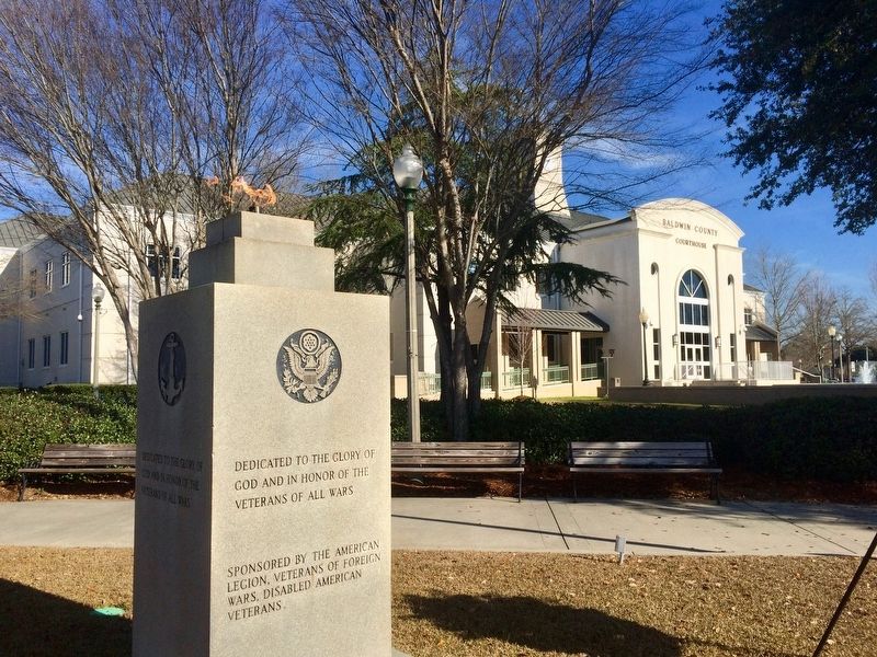
Memorial located on lawn of Baldwin County Courthouse.
| 1 ► Alabama, Baldwin County, Bay Minette — Baldwin County Eternal Flame Veterans Memorial — |
| On Courthouse Square (U.S. 31) at D'Olive Street, on the left when traveling east on Courthouse Square. | |||
| 2 ► Alabama, Baldwin County, Daphne — Patriot's Point Memorial — |
| Near U.S. 98 at Whispering Pines Road. | |||
| 3 ► Alabama, Baldwin County, Fairhope — Tears of Sorrow — Tears of Joy — |
| On N Beach Road. | |||
| 4 ► Alabama, Baldwin County, Gulf Shores — Officer’s Row — |
| On Fort Morgan Road (State Road 180) 1.3 miles west of Dune Drive, on the left when traveling west. | |||
| 5 ► Alabama, Baldwin County, Spanish Fort — 173d Airborne Brigade (Sep) — 1963 — 1971 — |
| On Alabama Route 225, 0.3 miles north of Upper Shay Branch Road. | |||
| 6 ► Alabama, Barbour County, Eufaula — In Honor of All World War II Veterans — |
| On East Broad Street east of North Randolph Avenue, on the left when traveling east. | |||
| 7 ► Alabama, Blount County, Blountsville — In Honor of Those Who Served — |
| Near Main Street South (U.S. 231) at Lee Street, on the right when traveling south. | |||
| 8 ► Alabama, Bullock County, Blues Old Stand — Three Notch Road — |
| On U.S. 29 at County Road 19, on the right when traveling south on U.S. 29. | |||
| 9 ► Alabama, Bullock County, Three Notch — Three Notch Road — |
| On U.S. 82 at County Road 35, on the right when traveling west on U.S. 82. | |||
| 10 ► Alabama, Calhoun County, Anniston — The Legacy of the Military / Anniston's Military Heritage — |
| On Quintard Avenue at East 17th Street, on the right when traveling north on Quintard Avenue. | |||
| 11 ► Alabama, Cherokee County, Cedar Bluff — Cherokee County Veterans Memorial — |
| On County Road 251, 0.1 miles north of County Road 714, on the right when traveling north. | |||
| 12 ► Alabama, Cherokee County, Centre — Cherokee County Veterans War Memorial — |
| On East Main Street (Business U.S. 411) at Iris Drive, on the right when traveling west on East Main Street. | |||
| 13 ► Alabama, Choctaw County, Butler — Military Memorial Walkway — |
| On South Mulberry Street (Alabama Route 17) south of West Pushmataha Street (Alabama Route 10), on the right when traveling south. | |||
| 14 ► Alabama, Clarke County, Thomasville — Thomasville War Memorial — Lest We Forget — |
| On 138 Wilson Avenue at West 2nd Street, on the right when traveling west on 138 Wilson Avenue. | |||
| 15 ► Alabama, Colbert County, Tuscumbia — Never Forget Garden — |
| On North Water Street at West 3rd Street, on the right when traveling south on North Water Street. | |||
| 16 ► Alabama, Colbert County, Tuscumbia — The Purple Heart / Military Order of the Purple Heart — |
| On North Main Street at West 3rd Street, on the right when traveling south on North Main Street. | |||
| 17 ► Alabama, Colbert County, Tuscumbia — U. S. Army M60A3 Main Battle Tank — |
| On South Water Street. | |||
| 18 ► Alabama, Covington County, Andalusia — Purple Heart Memorial — Combat Wounded — |
| Near E 3 Notch Street at 6th Avenue, on the right when traveling west. | |||
| 19 ► Alabama, Covington County, Andalusia — Rodney J. Evans — |
| Near East 3 Notch Street. | |||
| 20 ► Alabama, Covington County, Florala — Downtown Square and Veterans Memorial Park — |
| On 5th Street at 5th Avenue (U.S. 331) on 5th Street. | |||
| 21 ► Alabama, Cullman County, Cullman — Combat Wounded Veterans — Military Order of the Purple Heart — 1782-1932 — |
| Near Sportsman Lake Road NW, 0.4 miles west of 2nd Avenue NW (Route 31). | |||
| 22 ► Alabama, Cullman County, Holly Pond — Veterans Memorial — |
| On Cemetary Road, 0.1 miles east of Wesley Avenue (County Road 1669), on the left when traveling east. | |||
| 23 ► Alabama, Dallas County, Selma — Dallas County Korean War Memorial — |
| Near Dallas Avenue (Alabama Route 22) at Rowell Drive. | |||
| 24 ► Alabama, Dallas County, Selma — Dallas County Vietnam Memorial — |
| Near Dallas Avenue at Rowell Drive. | |||
| 25 ► Alabama, Dallas County, Selma — Dallas County World Wars Memorial — Lest· We· Forget — World War I 1917-1918 — World War II 1941-1945 — |
| Near Dallas Avenue (Alabama Route 22) at Rowell Drive. | |||
| 26 ► Alabama, DeKalb County, Fort Payne — Fort Payne’s Fort — |
| On Gault Avenue North (U.S. 11) east of 4th Street, on the right when traveling east. | |||
| 27 ► Alabama, DeKalb County, Sulphur Springs — POW-MIA Memorial — |
| Near Interstate 59, 1 mile north of County Road 140, on the right when traveling south. | |||
| 28 ► Alabama, DeKalb County, Sulphur Springs — Veterans Memorial — |
| Near Interstate 59, 1 mile north of County Road 140, on the right when traveling south. | |||
| 29 ► Alabama, Etowah County, Attalla — Camp Sibert — World War II: 1942-1945 — |
| On Gilbert Ferry Road SE (State Highway 77) north of Case Avenue SE, on the left when traveling north. | |||
| 30 ► Alabama, Jefferson County, Birmingham — Disabled American Veterans — |
| Near 2nd Avenue North near 3rd Street North. | |||
| 31 ► Alabama, Jefferson County, Birmingham — History of the 117th Tactical Reconnaissance Wing — |
| Near East Lake Boulevard at 57th Street North, on the right when traveling east. | |||
| 32 ► Alabama, Jefferson County, Birmingham — Raymond Weeks — Founder of National Veterans Day — |
| On Reverend Abraham Woods Jr Boulevard east of 20th Street North, on the right when traveling east. | |||
| 33 ► Alabama, Lamar County, Vernon — Lamar County Korea & Vietnam Memorial — |
| On Pond Street (Alabama Route 17) at 1st Avenue NE, on the right when traveling north on Pond Street. | |||
| 34 ► Alabama, Lamar County, Vernon — Lamar County WWI & WWII Memorial — |
| On Pond Street (Alabama Route 17) at 1st Avenue NE, on the right when traveling north on Pond Street. | |||
| 35 ► Alabama, Lauderdale County, Anderson — Hugh Pate Harris — General, U.S. Army — |
| On Alabama Route 207 at milepost 7 south of Hammond Street, on the right when traveling south. | |||
| 36 ► Alabama, Lauderdale County, Florence — 16” Projectile — |
| On Veterans Park Drive, 0.3 miles east of South Cox Creek Parkway, on the left when traveling east. | |||
| 37 ► Alabama, Lauderdale County, Florence — AGM-28 Hound Dog Missile — |
| On Veterans Park Drive, 0.3 miles east of South Cox Creek Parkway (Alabama Route 133), on the left when traveling east. | |||
| 38 ► Alabama, Lauderdale County, Florence — Anti-Tank Gun — |
| On Veterans Park Drive, 0.2 miles east of South Cox Creek Parkway (Alabama Route 133), on the left when traveling east. | |||
| 39 ► Alabama, Lauderdale County, Florence — General Arthur E. Brown, Jr. — City of Florence Walk of Honor — |
| Near Hightower Place just south of Veterans Drive (Alabama Route 133), on the left when traveling south. | |||
| 40 ► Alabama, Lauderdale County, Florence — General Hugh Pate Harris — City of Florence Walk of Honor — |
| Near Hightower Place south of Veterans Drive (Alabama Route 133), on the left when traveling south. | |||
| 41 ► Alabama, Lauderdale County, Florence — Global War on Terrorism — War on Terrorism Service Medal — |
| On Veterans Park Drive at Don Michael Drive on Veterans Park Drive. | |||
| 42 ► Alabama, Lauderdale County, Florence — Lt. Col. R. Edward Yeilding — City of Florence Walk of Honor — |
| Near Highttower Place south of Veterans Drive (Alabama Route 133), on the left when traveling south. | |||
| 43 ► Alabama, Lauderdale County, Florence — Rear Admiral Fran McKee — City of Florence Walk of Honor — |
| Near Hightower Place south of Veterans Drive (Alabama Route 133), on the left when traveling south. | |||
| 44 ► Alabama, Lauderdale County, Florence — The “Honest John” Rocket — |
| On Veterans Park Drive, 0.3 miles east of South Cox Creek Parkway (Alabama Route 133), on the left when traveling east. | |||
| 45 ► Alabama, Lauderdale County, Florence — The Hawk Missile — |
| On Veterans Park Drive, 0.2 miles east of South Cox Creek Parkway (Route 133), on the left when traveling east. | |||
| 46 ► Alabama, Limestone County, Athens — Athens College Veteran's Memorial — |
| Near East Pryor Street at Elkton Street, on the left when traveling west. | |||
| 47 ► Alabama, Limestone County, Athens — Night Chaparral — |
| Near Pryor Street West. | |||
| 48 ► Alabama, Limestone County, Elkmont — Alabama Combat Infantrymen Monument — |
| Near Interstate 65 at milepost 365 when traveling south. | |||
| 49 ► Alabama, Madison County, Brownsboro — Trail of Tears — Drane/Hood Overland Route — |
| On Lee Highway/John T. Reid Parkway (U.S. 72 at milepost 109) at Brock Road, on the right when traveling west on Lee Highway/John T. Reid Parkway. | |||
| 50 ► Alabama, Madison County, Huntsville — Major General H.N. Toftoy, USA. — |
| On Westside Square, on the right when traveling south. | |||
| 51 ► Alabama, Madison County, Huntsville — Memorial Fountains — Huntsville Madison County Veterans Memorial — |
| On Monroe Street Northwest at Jefferson Street North, on the right when traveling west on Monroe Street Northwest. | |||
| 52 ► Alabama, Madison County, Madison — Madison County Veterans — |
| On Front Street west of Church Street, on the left when traveling west. | |||
| 53 ► Alabama, Marshall County, Guntersville — History of Guntersville — |
| On Florida Short Route/Gunter Avenue (U.S. 431) at Lurleen B Wallace Drive, on the right when traveling south on Florida Short Route/Gunter Avenue. | |||
| 54 ► Alabama, Mobile County, Dauphin Island — British Occupation of Dauphin Island — February - April 1815 — |
| Near Bienville Boulevard east of Albatross Street, on the right when traveling east. | |||
| 55 ► Alabama, Mobile County, Dauphin Island — Patriot — 4 July 2016 — |
| On Bienville Boulevard at Lackland Street, on the right when traveling east on Bienville Boulevard. | |||
| 56 ► Alabama, Mobile County, Grand Bay — Mark 8 Projectile — |
| Near Interstate 10, 1 mile Mississippi/Alabama State Line. | |||
| 57 ► Alabama, Mobile County, Mobile — A National Cemetery System — |
| Near Virginia Street just east of Murphy Street. | |||
| 58 ► Alabama, Mobile County, Mobile — Australia — Korean War Memorial — |
| Near Battleship Parkway at Old Spanish Trail (U.S. 98). | |||
| 59 ► Alabama, Mobile County, Mobile — Canada — Korean War Memorial — |
| Near Battleship Parkway at Old Spanish Trail. | |||
| 60 ► Alabama, Mobile County, Mobile — Colombia — Korean War Memorial — |
| Near Battleship Parkway at Old Spanish Trail. | |||
| 61 ► Alabama, Mobile County, Mobile — Ethiopia — Korean War Memorial — |
| Near Battleship Parkway at Old Spanish Trail. | |||
| 62 ► Alabama, Mobile County, Mobile — Horace O. Davis — |
| On Battleship Parkway. | |||
| 63 ► Alabama, Mobile County, Mobile — M26 Pershing — |
| Near Battleship Parkway at Old Spanish Trail (U.S. 98). | |||
| 64 ► Alabama, Mobile County, Mobile — M42 Duster — |
| Near Battleship Parkway at Old Spanish Trail (U.S. 98). | |||
| 65 ► Alabama, Mobile County, Mobile — M60A1 — |
| Near Battleship Parkway at Old Spanish Trail (U.S. 89). | |||
| 66 ► Alabama, Mobile County, Mobile — Netherlands — Korean War Memorial — |
| Near Battleship Parkway at Old Spanish Trail (U.S. 98). | |||
| 67 ► Alabama, Mobile County, Mobile — T-55 Main Battle Tank — |
| Near Battleship Parkway at Old Spanish Trail (U.S. 98). | |||
| 68 ► Alabama, Mobile County, Mobile — Tank M48A1 — |
| Near Battleship Parkway (U.S. 98) 2.3 miles west of Interstate 10. | |||
| 69 ► Alabama, Mobile County, Mobile — Thailand — Korean War Memorial — |
| Near Battleship Parkway at Old Spanish Trail. | |||
| 70 ► Alabama, Mobile County, Mobile — The Fallen Guardians Monument — |
| On Battleship Parkway, on the right when traveling south. | |||
| 71 ► Alabama, Mobile County, Mobile — U.S. Coast Guard Monument — Mobile, Alabama — |
| On South Water Street. | |||
| 72 ► Alabama, Montgomery County, Maxwell Air Force Base — Fourth Aviation Squadron Historic District — Montgomery County — |
| On Washington Ferry Road west of Beech Street, on the right when traveling west. | |||
| 73 ► Alabama, Montgomery County, Maxwell Air Force Base — The Air Corps Tactical School — |
| On Lemay Plaza, 0.1 miles north of East Shumacher Avenue, on the right when traveling north. | |||
| 74 ► Alabama, Montgomery County, Maxwell Air Force Base Gunter Annex — Airman First Class John L. Levitow Monument — |
| Near McDonald Street at Williamson Street. | |||
| 75 ► Alabama, Montgomery County, Maxwell Air Force Base Gunter Annex — Army Air Corps Enlisted Pilots — 1912 — 1942 — |
| Near Avenue D at Libby Street. | |||
| 76 ► Alabama, Montgomery County, Maxwell Air Force Base Gunter Annex — Khobar Towers — Never To Be Forgotten — June 25, 1996 — |
| On Avenue D, on the right when traveling south. | |||
| 77 ► Alabama, Montgomery County, Maxwell Air Force Base Gunter Annex — Operation Noble Eagle — |
| Near Avenue D at Libby Street. | |||
| 78 ► Alabama, Montgomery County, Maxwell Air Force Base Gunter Annex — The Spirit of the Minuteman — |
| Near McDonald Street at Avenue D. | |||
| 79 ► Alabama, Montgomery County, Montgomery — Camp Sheridan — |
| On Johnson Avenue east of Lower Wetumpka Road, in the median. | |||
| 80 ► Alabama, Montgomery County, Montgomery — Major Lemuel Purnell Montgomery — 1786 - 1814 — |
| On South Lawrence Street at Adams Avenue, on the left when traveling south on South Lawrence Street. | |||
| 81 ► Alabama, Montgomery County, Montgomery — Naval Heroes of the War of 1812 — Dexter Avenue, Montgomery, Alabama — |
| On Dexter Avenue at South McDonough Street, on the right when traveling east on Dexter Avenue. | |||
| 82 ► Alabama, Montgomery County, Montgomery, Boylston — 9th Infantry Division / “The Old Reliables” — |
| On Johnson Avenue east of Lower Wetumpka Road, in the median. | |||
| 83 ► Alabama, Montgomery County, Pike Road — Town of Pike Road Veterans Memorial — |
| On Pike Road (County Route 85) at Hudson Road, on the right when traveling south on Pike Road. | |||
| 84 ► Alabama, Morgan County, Priceville — M601A Tank — |
| Near Willowbrook Street near Alabama Route 67 when traveling west. | |||
| 85 ► Alabama, Morgan County, Priceville — Morgan County Veterans Memorial — Dedicated November 11, 2012 — |
| Near Willowbrook Street north of Alabama Route 67. | |||
| 86 ► Alabama, Morgan County, Priceville — Prisoner of War or Missing in Action — POW*MIA — |
| Near Willowbook Street north of Alabama Route 67. | |||
| 87 ► Alabama, Morgan County, Priceville — United States Army — Army — |
| On Willowbrook Street near Hwy 67 and Willowbrook St. | |||
| 88 ► Alabama, Morgan County, Priceville — United States Marines — Marines — |
| On Alabama Route 67 near Hwy 67 and Willowbrook St. | |||
| 89 ► Alabama, Morgan County, Priceville — United States Navy — Navy — |
| On Willowbrook Street near Hwy 67 and Willowbrook Rd. | |||
| 90 ► Alabama, Morgan County, Priceville — USS San Jose (AFS-7)Anchors / BOFORS TWIN 40mm Anti-Aircraft Gun — |
| Near Willowbrook Street north of Alabama Route 67 when traveling west. | |||
| 91 ► Alabama, Perry County, Marion — Perry County Veterans Memorial — |
| On Washington Street at Jackson Street, on the right when traveling north on Washington Street. | |||
| 92 ► Alabama, Pike County, Brundidge — "Lest We Forget" — |
| On South Main Street (Alabama Route 93) at Oak Street, on the left when traveling north on South Main Street. | |||
| 93 ► Alabama, Pike County, Goshen — Memorial — |
| On South Montgomery Street, 0.2 miles east of Glenwood Road, on the right when traveling south. | |||
| 94 ► Alabama, Randolph County, Wedowee — World War II, Korea and Vietnam War Memorial — |
| On N Main St at West Broad Street, on the left when traveling north on N Main St. | |||
| 95 ► Alabama, Russell County, Fort Mitchell — Address by President Lincoln — At the Dedication of The Gettysburg National Cemetery — November 19, 1863 — |
| On James Cantey Boulevard east of Alabama Route 165, on the right when traveling north. | |||
| 96 ► Alabama, Russell County, Fort Mitchell — Fort Mitchell Military Cemetery — |
| Near U.S. 165. | |||
| 97 ► Alabama, Sumter County, York — York Veterans War Memorial — Lest We Forget — |
| On Broad Street (Alabama Route 17) at Conti Street, on the right when traveling south on Broad Street. | |||
| 98 ► Alabama, Talladega County, Talladega — USS Talladega (APA-208) — Talladega County — “The Tremblin’ T” — |
| On W. North Street at Court Square West, on the left when traveling west on W. North Street. | |||
| 99 ► Alabama, Tallapoosa County, Camp Hill — Lyman Ward Military Academy — |
| On Pittman Avenue (State Highway 50) at Ward Circle, on the right when traveling west on Pittman Avenue. | |||
| 100 ► Alabama, Tuscaloosa County, Tuscaloosa — Answering the Call to Duty — City of Tuscaloosa — |
| Near 7th Street at 21st Avenue, on the right when traveling west. | |||
8460 entries matched your criteria. The first 100 are listed above. Next 100 ⊳