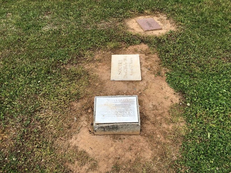
The only gravestone not removed during the 1913 landscaping was Squire's, which archaeologists discovered in place. Squire, an enslaved African American, was digging a well near the wool factory that was built for land owned by Moravian . . . — — Map (db m172105) HM
What began as the Parish Graveyard was extended westward to the street and designated in 1816 as the resting place for all African Americans, Moravian or not, who died in and around Salem. From that date forward, all Christian whites were then . . . — — Map (db m172103) HM
Governor of North Carolina, 1945 - 1949. State legislator. Promoted good roads and rural electrification. Grave is 3 miles S.E. — — Map (db m108789) HM
Here lie the bodies of the Cherokee Chief, Junaluska, and Nicie, his wife. Together with his warriors he saved the life of General Jackson, at The Battle of Horseshoe Bend, and for his bravery and faithfulness, North Carolina made him a citizen, and . . . — — Map (db m209701) HM
Leader of women in their quest for finer and more productive living - mentor by her writings, of those seeking to live graciously - by her eloquence, inspired youth to nobler achievements; by her vigor of mind and force of character, championed for . . . — — Map (db m215873) HM
Brig–Gen. Jethro Sumner
Born in the year 1733
Died March 18, 1785
———
Colonel of the Third North Carolina
Continental Troops
April 15, 1776
Charleston, June 28, 1776
Brandywine, Sept. 11, 1777
Germantown, Oct. 4, 1777
Monmouth, . . . — — Map (db m219404) HM
John Penn Signer of the Declaration of Independence Placed by Descendants of the Signers of the Declaration of Independence, Inc. — — Map (db m221870) HM
In Memoriam William Hooper and John Penn delegates from North Carolina 1776 to the Continental Congress and signers of the Declaration of Independence. Their remains were reinterred here 1894. Hewes’ grave is lost. He was the third signer. . . . — — Map (db m34883) HM
This monument honors the three North Carolina delegates to the Continental Congress who signed the Declaration of Independence of July 4, 1776. Although Hooper and Penn were reburied here in 1894, they had no direct ties to the battle. The relation . . . — — Map (db m11891) HM
This tree stood in the center of New Garden burying ground. Here the first skirmish of the Battle of Guilford Court House occurred, 3d. month 1781.
Nearby are the cornerstones of the original Friends meeting house, used as a hospital during the . . . — — Map (db m242313) HM
William Hooper Signer of the Declaration of Independence Placed by Descendants of the Signers of the Declaration of Independence, Inc. — — Map (db m81686) HM
(side 1)
Original Methodist Church
1831
Here in 1830-31, 64 Methodists led by Peter Doub built the first church in Greensboro. Moving to a second church on West Market Street in 1851, the congregation relocated a third and final . . . — — Map (db m35093) HM
On this site, members of the First Presbyterian Church of Greensboro built their first house of worship in 1832, and on the adjacent land citizens of Greensboro erected the first graded public school in North Carolina in 1875. These grounds and the . . . — — Map (db m54095) HM
Greensboro's oldest known
African American cemetery
has been placed on the
National Register
of Historic Places
by the United States
Department of the Interior
1993 — — Map (db m234102) HM
Greenhill Cemetery was established in 1910 for
$750 when the city of High Point purchased
6 acres of land for burial of its colored citizens.
Today the cemetery is situated on approximately
11 acres of land and consists of 1250 burial . . . — — Map (db m234026) HM
From the eras of slavery to segregation, a time spanning from the 1700's to the 1970's, the laws of North Carolina and many other states mandated that all citizens be labeled as “White” or “Colored.”
When the Oakwood Cemetery was established in . . . — — Map (db m234023) HM
A church has existed here since the early 1800s. Constructed as a one-room church in 1901 and expanded to cruciform structure in 1929. Ai refers to Old Testament hilltop Canaanite royal city. Adjacent cemetery includes 1819 grave of Nathan Dillon, . . . — — Map (db m246370) HM
Church site purchased in 1889 by Oak Ridge's oldest African-American congregation. Sanctuary served as classroom for African American students until a schoolhouse was built next door c. 1915. Indoor plumbing and fellowship hall added in 1980s. . . . — — Map (db m234041) HM
Revolutionary Leader
and Founder of Bruce's Cross Roads
(now Summerfield)
and
grave of James Gillies
Light Horse Harry Lee's Bugler
slain by British Feb. 12, 1781. — — Map (db m234035) HM
Methodist Protestant minister. President of the General Conference, 1866. Head of Halifax Male Academy & Elba Female Seminary. Grave here. — — Map (db m220890) HM
Graves of Confederate general Junius Daniel, editor Abraham Hodge, United States District Judge John Sitgreaves, are 1 bl. N.E. — — Map (db m221534) HM
In 1793, the first Halifax church was built at this location. The Free Church was open to all denominations. Services were held until the 1850’s when congregations began to build their own churches. In 1911 the church fell in disrepair and . . . — — Map (db m222096) HM
Colonel in Revolution. Member of Continental Congress, 1778-1781; of Provincial Congresses; and of state legislature. Grave 125 yds. S.E. — — Map (db m221571) HM
In grateful memory of the brave men who sleep in Chicora Cemetery. They fought their last fight March 16, 1865 on this third line breastworks of Averasboro Battlefield. — — Map (db m34301) HM
The first Locust Old Fields Baptist Church was established here in 1803. It was among the first churches established west of Asheville. Although the original building no longer stands, it served the small community here for many years as a house of . . . — — Map (db m75504) HM
Col. William Holland Thomas (February 5, 1805-May 10, 1893) is among the Confederate officers and soldiers buried here in Greenhill Cemetery. His grave is located about thirty yards in front of you on the right.
Thomas, who began trading with . . . — — Map (db m75487) HM
1850 - 1896
American Humorist
I will turn their mourning into Joy and will Comfort them and make the rejoice from their sorrow. Jeremiah 34:13 — — Map (db m17797) HM
Marble statue from the Asheville shop of W.O.Wolfe. Inspired title of son Thomas Wolfe's Look Homeward Angel. Stands 150 feet south. — — Map (db m12421) HM
These gravesites contain the bodies of four British seamen. Their ship, the armed trawler HMS Bedfordshire, was on loan to our Navy by Great Britain to help protect our shores during the early days of World War II.
On May 11, 1942 the . . . — — Map (db m38781) HM
The History of Centre Presbyterian Church Centre Church was organized in 1765 and held meetings at Osborne's Meeting House. This new congregation's mission was centrally located between five other missions: Sugar Creek, Hopewell, Fourth Creek . . . — — Map (db m237253) HM WM
Dedicated by the Presbyterian church to the memory of the pioneers and to the soldiers of the Indian wars, the Revolution and the Confederacy who lie buried here.
Built by the pioneers, this wall was reconstructed by the national government and . . . — — Map (db m51803) HM
The boyhood home
of
Dr. John R. Brinkley
and his
Aunt Sally.
Her grave is on the hilltop across the river. She is remembered and loved for her ministrations to the sick of this community.
In loving memory
by
her "little boy . . . — — Map (db m176818) HM
The remains of 360 Confederates who fell in the Battle of Bentonville lie here. They were moved to this plot from other parts of the battlefield in 1893. The monument was erected at that time. — — Map (db m222876) HM
In memory of the Confederate dead Erected under the auspices of Goldsboro Rifles October 10, 1894. ♦♦♦ [ Left of Monument: ] On this spot and in this vicinity was fought the Battle of Bentonville March 19, 1865. . . . — — Map (db m222884) HM
“Time may teach us to forgive, but it can never make us forget.” - Confederate Lt. Gen. Wade Hampton, memorial address at Bentonville, March 20, 1895. By the evening of March 22, 1865 both the Union and Confederate armies had vacated . . . — — Map (db m222883) HM
Congressman, 1901-1934. Chairman House Rules Committee during parts of administrations of Wilson, F.D. Roosevelt. Grave is 200 yds. south. — — Map (db m70388) HM
As the fighting surged past the church and the battle moves into Kinston, surgeons of both armies began the task of caring for the wounded. Harriet’s Chapel became a refuge and men from both sides found care at the church.
The fighting around . . . — — Map (db m70424) HM
Presbyterian, 1801. Graves include those of Alexander Brevard, Joseph & James Graham, and Robert Hall & Joseph Graham Morrison. — — Map (db m156520) HM
"Old White Church" Cemetery First Burying Ground in Lincolnton ca. 1787 Has been placed on the National Register of Historic Places by the United States Department of the Interior" Old White Church" Lincolnton's original house of worship . . . — — Map (db m44431) HM
Native German, pioneer teacher and minister, ordained 1775, first president of the N.C. Lutheran Synod, 1803. Grave a few yds. east. — — Map (db m44402) HM
Burial site of Jacob Plonk (c.1747-1845)
Patriot of the American Revolution
His wife, Christina Kiser Plonk, son Joseph Plonk, his wife Barbara Rudisill Plonk, and Plonk, Hauss, Heafner, and Tutherow descendants. One of many early . . . — — Map (db m231840) HM
Burial site of Jacob Ramsour and Christian Reinhardt. Possible burial site of pioneer Johan Dietrich Ramsauer. Located 800 feet west. — — Map (db m232305) HM
By the spring of 1780 the war for America's independence, begun five years earlier in Massachusetts, had moved south. Following decisive victories in Georgia and South Carolina, the British army under the command of Lord Cornwallis was poised to . . . — — Map (db m44428) HM
Buried here is Loyalist John Martin Shuford who died June 22, 1780 of wounds received in the Battle of Ramsour's Mill. His grave was originally marked with an old headstone and footstone. In 1997 the Lincoln County Historical Association and Shuford . . . — — Map (db m231966) HM
In the spring of 1870, 169 Confederate soldiers from local C.S. hospital cemeteries were reinterred in this section. As of spring of 1996, 105 war dead and 3 postwar graves have been marked by the Maj. Egbert A. Ross Camp, Sons of Confederate . . . — — Map (db m237553) HM
Charlotte and Mecklenburg County's character today is deeply rooted in the independent mindedness of our early citizens. Settled largely by Scots-Irish Presbyterians with many Germans and some English and French, Mecklenburg was carved from the . . . — — Map (db m175528) HM
In 1815, town commissioners set aside this site for a church used by all denominations. It was called the Brick Church or Town Church. Its cemetery, Settlers' Cemetery, continues to be town property. Presbyterians predominated in the town and in . . . — — Map (db m175522) HM
100 years ago Fourth Ward held many Victorian houses, Charlotte's first hospital, and industries including the Charlotte Cotton Mill.
When residents left for the suburbs after WWII, Fourth Ward went into decline. But led by women of the Junior . . . — — Map (db m175568) HM
Colonel Thomas Polk (1732-1793), the great uncle of President James K. Polk, was one of Mecklenburg's first commissioners, a signer of the Mecklenburg Declaration of Independence, a delegate to the Continental Congress in 1786, and in 1791 hosted . . . — — Map (db m175555) HM
Settlers' Cemetery is of the great historic significance because it is the oldest municipal cemetery in Charlotte. With surviving gravestones from 1775 - 1884, it is the resting place for many of Mecklenburg County's founding families and . . . — — Map (db m175557) HM
On the second block from The Square, occupying nearly a full city block, the old Settlers' Cemetery where you stand lies quietly in the heart of uptown Charlotte. Even though it is across Fifth Street from First Presbyterian Church, it was never . . . — — Map (db m175554) HM
Charlotte was established in 1768 by settlers who were, for the most part, Scots-Irish Presbyterians. In the first quarter of the nineteenth century, a church was built in "town" to be used by all denominations. Presbyterian minister John Thomson . . . — — Map (db m175561) HM
On May 20, 1861, North Carolina seceded from the Union to join the "Confederate States of America." In Charlotte, the United States Mint was taken over as Confederate headquarters. Students and faculty from the new Charlotte Military Academy went . . . — — Map (db m175553) HM
Pleasant Grove Methodist Church was organized in 1888 with services held under a brush arbor directly across the road, and a building placed there the
same year. it was replaced in 1908 by a building on this site. In 1947 a third structure was . . . — — Map (db m180605) HM
Lieutenant General, C.S.A.; Supt. N.C. Military Institute in Charlotte; Davidson College professor; Editor, “The Land We Love.” Grave is here. — — Map (db m72902) HM
To the memory of General William Lee Davidson of Mecklenburg County N.C. Born in 1746. Youngest son of George Davidson of Lancaster, PA. who moved to Mecklenburg Co., North Carolina, in 1750. Major 4th Reg. North Carolina Troops. Promoted . . . — — Map (db m63062) HM
In my anguish I cried to the Lord, and he answered by setting me free. The Lord is with me; I will not be afraid. What can a man do to me? The Lord is with me; he is my helper. – Psalm 118:5-7
You are standing before the oldest continuously existing human institution in northern Mecklenburg County: Hopewell Presbyterian Church. There were seven churches in this southern region of North Carolina Piedmont before the Revolutionary War. . . . — — Map (db m63275) HM
This historic burial ground is the final resting place of early settlers
who traveled the Great Wagon Road from Pennsylvania to what is now
the Mint Hill area. In 1770, they established Clear Creek
Presbyterian Church (now Philadelphia . . . — — Map (db m237896) HM
Polk Family Cemetery As one of Mecklenburg County's early family graveyards, the Polk family cemetery has special importance to the history of the area. The cemetery is the resting place for James K. Polk's grandmother, Maria Polk, and several . . . — — Map (db m198696) HM
Henry F. (Lowe) Warner, native of Troy, was awarded the Medal of Honor, our nation's highest military decoration, for heroism on Dec. 20-21, 1944 during the Battle of the Bulge. He was killed in action the morning of the 21st. He is buried 200 yards . . . — — Map (db m245491) HM
Four score and seven years ago our fathers brought forth on this continent, a new nation, conceived in Liberty, and dedicated to the proposition that all men are created equal. Now we are engaged in a great civil war, testing whether that nation, . . . — — Map (db m222492) HM
Civil War Wilmington Wilmington was a minor Atlantic port when the Civil War started and the U.S. Navy did little to secure it. In fall 1862, the Confederate Ordnance Bureau designated it as the port of entry for its blockade runners. At night . . . — — Map (db m223962) HM
Near this spot lies
Thomas Godfrey
Born in Philadelphia Pa. 1736
Died in Wilmington N.C. 1763
Author of
The Prince of Parthia
The first drama written
by an American and
produced upon the
professional stage in
the Colonies . . . — — Map (db m28759) HM
The Church of The Saviour (1898)
and Cemetery (1853)
Have been placed on the
National Register
of Historic Places
by the United States
Department of the Interior — — Map (db m180478) HM
Presbyterian. Served by Hugh McAden, 1755-65. Henry Pattillo was first pastor. Church moved to Cedar Grove in 1893. Cemetery one mile S. — — Map (db m223139) HM
Although it lies in the shadow of a historic church, Hillsborough's Old Town Cemetery is not a traditional churchyard burial ground. One of North Carolina's oldest municipal cemeteries, it was established in 1757 by the colonial Assembly and is the . . . — — Map (db m232411) HM
This historic churchyard unifies five tracts of land given between 1824 and 1934 by Thomas Carter Ruffin and his Cameron family descendants. The pathway system and Memorial Garden were added in 2007 through the generosity of parishioners.
The . . . — — Map (db m187668) HM
William Hooper Esquire
Signer
Declaration of Independence
July 4th, 1776
Sponsored by the Davie Poplar Chapter
Erected by National Society of Daughters of the American Revolution of North Carolina
1937 — — Map (db m139769) HM
Sponsored the 1891 bill to establish present-day Elizabeth City State University; legislator, 1876-80, 1885, 1891. His grave is 6/10 mile west. — — Map (db m56816) HM