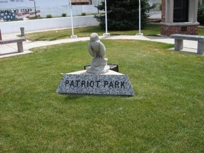
On Main Street at East West Street, on the right when traveling north on Main Street.
In Honor of
All
Who Have Served
Who Are Serving
Who Will Serve
Left Bench
In Honor of Our Veterans
Right Bench
In Honor of All Patriots
Within glass cases are names of local veterans who have served or . . . — — Map (db m11358) WM
Because of the often soggy conditions that discouraged use as either residential or commercial property, the area of Headwaters Park became known as the Jail Flats. The first jail in Allen County was a two-story hewn-log structure that was enclosed . . . — — Map (db m197061) HM
On East Main Street near South Barr Street, on the right when traveling west.
A capsule was buried on this site on May 11, 2002 when citizens of Takaoka and Fort Wayne met to re-affirm an alliance established in 1977. The capsule, containing articles related to the 25th anniversary, will be opened on the occasion of the . . . — — Map (db m239279) HM
On 3000 County Road 300 E (State Road 55) at County Road E 300 N, on the right when traveling north on 3000 County Road 300 E.
(Tablet 1)
This boulder marks a boundary line between United States territory and Indian lands which existed for fourteen years.
At St. Mary's Ohio on October 2, 1818, a treaty was made and concluded between Jonathan Jennings, Lewis . . . — — Map (db m71919) HM
On State Road 18 west of County Road N200W, on the right when traveling east.
In October 1818, Purchasing Commissioners Lewis Cass, Benjamin Parke and Governor Jonathan Jennings acquired Indian claims on the land shown on this marker. About one-third of modern Indiana, was involved in this transaction. — — Map (db m21517) HM
On State Road 44 at South Gabbard Road, on the right when traveling east on State Road 44.
This plaque marks the western border of the twelve mile cession negotiated by Governor William Henry Harrison with the Miami, Potawatomi, and Delawares, Treaty of Fort Wayne, September 30, 1809. — — Map (db m44770) HM
On East Market Street east of East 10th Street, on the left when traveling east.
In honored memory of Floyd County
Servicemen who sacrificed their
lives for World Peace
SGT. Christopher K. Hilgert U.S. Army
• Aug. 8, 1993 • Somalia
SGT. Steven P. Mennemeyer US. Army
• Aug. 8, 2006 • Iraq . . . — — Map (db m46943) WM
Near North Park Street north of East Hayes Street.
World War - I
Orel A. Smith, Born 1898, 32nd Co. 6th Marine Vol., Killed In Action, Nov. 2, 1918 • Lieut. W. E. G. Cooper, Born March 29, 1888, Killed In Action at Chateau Thierry, July 20, 1918 • Claude L. Wilkinson, Born June 9, 1893, Killed . . . — — Map (db m7884) WM
On West State Street just west of North West Street, on the right when traveling east.
WHEREAS, the citizens of the City/County of Princeton, Gibson County, Indiana, USA and Tahara-cho, Japan do mutually agree to establish a Friendship city/county affiliation to deepen the friendship and confidence between our countries and to . . . — — Map (db m190737) HM
On North Capitol Avenue (State Road 62) at East Walnut Street, on the right when traveling north on North Capitol Avenue.
(Center Panel):
Dedicated
in
Everlasting Tribute
to
World War II
Veterans
of
Harrison County
and
to the Enduring
Memory of our
Hallowed Dead
Lest we forget, they died
that we may live
(Immediate Left of Center . . . — — Map (db m79524) WM
Near North Apperson Way at North Lafountain Street, on the right when traveling south.
Dr. King was awarded the Nobel Peace Prize in 1964. He spoke about that in relation to his activities in support of voting rights in Selma, Alabama later that year. During the March from Selma to Montgomery, Alabama saw horrific violence against . . . — — Map (db m231953) HM
On Hart Street west of 1st Street, on the left when traveling west.
The great Shawnee leader lives on as a symbol of Native pride and pan-Indian identity. In the years 1810 and 1811 Tecumseh defended the rights of his people in meetings in Vincennes with William Henry Harrison, Governor of the Indiana Territory. . . . — — Map (db m61831) HM
On Madison Street north of Madison Lane, on the right when traveling north.
U.S. Representative Katie Hall, standing second from left, witnesses along with other national dignitaries as Ronald Reagan, 40th President of the United States of America, signs federal legislation establishing a national holiday honoring the . . . — — Map (db m241793) HM
On Madison Street south of West 19th Avenue, on the left when traveling south.
Representative Katie Hall (1938-2012). Democratic leader Katie Hall was born in rural Mississippi and moved to Indiana in 1960. She taught in Gary before serving in the Indiana General Assembly, 1974-82. Hall became the first African American . . . — — Map (db m241795) HM
On Indiana's Historic Pathways - North Spur (U.S. 50) 0.4 miles east of Connerly Cemetery Road, on the left when traveling west.
This marker is on the northern boundary of the Vincennes Tract, the first Indian cession obtained by Governor William Henry Harrison in the Indiana Territory.
The treaty was signed by chiefs of the Miami, Delaware, Shawnee, Potawatomi, Eel . . . — — Map (db m243588) HM
Here in Callaway Park August 17, 1940, Willkie accepted Republican party presidential nomination after a nationwide grassroots campaign. An estimated crowd of 250,000 was in the park and along adjacent streets. Established campaign headquarters in . . . — — Map (db m1186) HM
On Limestone Street north of Porto Alegre Street, on the right when traveling south.
The IUPUI International House was founded in 1991 as a cross-cultural living-learning community dedicated to international understanding. It brings together students from many different countries--including the United States--to live alongside . . . — — Map (db m132731) HM
On South Audubon Road close to Julian Avenue, on the left when traveling south.
Suffragist and political activist Grace Julian Clarke moved to Irvington by 1874 and lived in the house here. She earned her BA and MA from Butler University. As Indiana Federation of Clubs president, 1910 to 1911, she advanced women’s social and . . . — — Map (db m174678) HM
Here on the evening of April 4, 1968, Kennedy came to address a large crowd of mostly African Americans in his bid for Democratic Party nomination for president of U.S. Instead, visibly shaken, he gave an impromptu speech about the assassination of . . . — — Map (db m236) HM
On East Washington Street at South Pennsylvania Street, on the left when traveling west on East Washington Street.
The son of a Baptist minister, Martin Luther King Jr. was the second of three children. In 1939, he sang with his church choir at the premiere of Gone with the Wind. His non-violent leadership for civil rights and racial equality transformed the . . . — — Map (db m132771) HM
On West Kirkwood Avenue at North College Avenue, on the right when traveling west on West Kirkwood Avenue.
a Quaker, served Monroe County on the
Board of Commissioners 1977-1984, and the
County Council 1970-1976, 1989-1994, 2004-2013.
Through his efforts Monroe County is one of only a few
counties within the United States that
has a Monument to . . . — — Map (db m242297) HM
On South Maple Street north of West Washington Street, on the left when traveling north. Reported permanently removed.
Dedicated to those who served
(Leftmost Panel of Brick Memorials)
First Column:
Grant C. Cornwell - (USAAC - S/SGT) - (2-1942 to 10-1945) -•- Lester R. Cornwell - (USN - GM3/C) - (8-1944 to 2-1946) -•- Leland W. Cornwell - (USA . . . — — Map (db m242018) HM
On Fourth Street (State Road 25) at Hickory Street, on the right when traveling south on Fourth Street. Reported missing.
May 1861 saw this high 30-acre bluff over-looking Lafayette quickly become an induction center for enlistees in the Civil War until its end in 1865. Ample water, good drainage and access to the railroad at its west end served the purpose well, . . . — — Map (db m8697) HM
On Market Street at South Main Street, on the left when traveling east on Market Street.
Dedicated to all veterans during war and peace time.
(Lower - Middle: panel):
Nothing hurts like being forgotten. Nothing helps like being remembered. For those who fight for it, life has a special flavor the protected never know. . . . — — Map (db m8930) WM
On Main Street at 16th Street / Glenn Miller Avenue, on the right when traveling west on Main Street.
We wish to promote peace and harmony like the music of Glenn Miller which brought our communities together. May this tree and this stone symbolize growth and stability of our Sister City relationship.
Frank Snyder, Mayor of Clarinda . . . — — Map (db m87424) HM
Near East Court Avenue south of Dey Street, on the right when traveling east.
In 1959, the Prefecture of Yamanashi, Japan suffered heavy damage from two typhoons, resulting in significant loss of human life, farm animals, homes and crops. An Iowan, stationed with the U.S. Air Force in Tokyo at that time, wanted to help. . . . — — Map (db m236175) HM
On Farnam Street at Federal Street on Farnam Street. Reported unreadable.
On September 21, 1832 General Winfield Scott & Governor Reynolds of Illinois negotiated the “Black Hawk Purchase” with the Sacs, Foxes, and the Winnebagos. The treaty deeded 6 million acres to the Americans. The price per acre was 9 cents. — — Map (db m230212) HM
Chief War Eagle
War Eagle, a Santee Sioux Indian was born during the 1780's in Minnesota or Wisconsin. In the early years of the 1800's, the Santee people lived in south eastern Minnesota. When tensions built up between the Indian people . . . — — Map (db m316114) HM
War Eagle
Waŋbdí Okíčhize is commonly known as War Eagle. While his name means Little Eagle, he was often referred to as War Eagle, which is odd because all through his life he sought to keep peace. He even left his home tribe the . . . — — Map (db m316113) HM
Near Wheelerwood Road 0.2 miles north of Iowa Highway 105.
Northern Iowa landforms result from the action of 3 separate glacial ice sheets. Clear Lake, south of here, is one of the many Iowa lakes formed by glacial action. Pilot Knob, a glacially formed hill west of here, is one of highest points in . . . — — Map (db m224584) HM
On U.S. 160 at the entrance to Memorial Peace Park, on the right when traveling east on U.S. 160.
At Medicine Lodge Creek in 1867, as many as 15,000 Apaches, Kiowas, Comanches, Arapahos, and Cheyennes gathered with a seven-member peace commission escorted by U.S. soldiers to conduct one of the nation’s largest peace councils. The American . . . — — Map (db m65195) HM
On West Fowler Avenue (U.S. 160/281) 0.5 miles west of Iliff Street (U.S. 281), on the right when traveling west.
Following the Civil War, westward expansion led to violence between settlers and Native tribes, prompting the U.S. to begin treaty talks. Representatives of five Southern Plains Indian tribes chose a meeting site where the present-day Medicine . . . — — Map (db m258699) HM
On Main Street at 1st Avenue, on the right when traveling north on Main Street.
To commemorate the signing of the peace treaties between the United States Government and the Five Tribes of Plains Indians at Medicine Lodge, Kans.
Oct. 21-28, 1867. — — Map (db m65128) HM
On Summit Street (U.S. 77) north of Maple Avenue, on the left when traveling north.
May 18, 1996
Torch Bearers
Charles Dow, Local Community Hero
Emily Bergkamp • Michael Goff
Amanda Crouse • Shaunta Lolar
Greg Gann • Trisha Morgan
Jenny Graham • Brooke Snowden
Nick Gilliland • Chad Taylor
100th Anniversary of the . . . — — Map (db m60510) HM
On Wyatt Earp Boulevard at Central Avenue, on the left when traveling east on Wyatt Earp Boulevard.
Buffalo Hunter
Deputy Sheriff of Ford County - 1876
Assistant Marshal of Dodge City - 1877
Deputy Marshal of Dodge City - 1876-1879 — — Map (db m65279) HM
On Spruce Street at 4th Avenue, on the left when traveling west on Spruce Street.
Called to Dodge City in 1876 and established law and order in a few years. He did the same thing for other cities and became known as the best law officer in the West. He was a quiet and decent man and caused considerable publicity for Dodge . . . — — Map (db m65386) HM
On 4th Street near Commercial Street, on the right when traveling east.
Depicting when the Osage dwelled east of the bluff near Horseshoe Lake and Chief White Hair was their Chief. John Mathews, a fur trader and blacksmith, lived on the summit, intermingling with the tribe, both cultures benefiting from the . . . — — Map (db m42284) HM
On Esplanade Street, on the right when traveling north.
In 1997, the cities of Leavenworth, Kansas and Omihachiman, Japan became Sister and Brother cities. The two cities are connected because of the civic and religious commitment of one man, Mr. William Merrell Vories.
Vories was born in Leavenworth . . . — — Map (db m42105) HM
On Bison Road (State Highway 15) at 130th Street on Bison Road.
Beginning in 1874, hundreds of peace-loving Mennonite immigrants settled in central Kansas. They had left their former homes in Russia because a hundred-year-old immunity from established religious orthodoxy and military service was being . . . — — Map (db m61058) HM
On Walnut Street at 1st Street, on the left when traveling south on Walnut Street.
This monument is an expression of deep gratitude
— to the City of Peabody for receiving the Mennonite immigrants, extending hospitality to them, and now granting a plot for this memorial,
— to the Santa Fe Railroad for directing the . . . — — Map (db m95256) HM
On Aztec Lane 0.2 miles east of 18th Avenue, on the left when traveling west.
Anabaptism originated in Switzerland in 1525 during the Reformation under the leadership of Conrad Grebel, Felix Manz, Georg Blaurock, and others. Most Anabaptists were later named "Mennonites" in recognition of the leadership of Menno . . . — — Map (db m57138) HM
On Aztec Lane 0.2 miles east of 18th Avenue, on the left when traveling west.
Elder Jacob Stucky and Rev. Jacob D. Goering laid the foundation for orderly church life that centered in the Immigrant House and later in the Hopefield Church, Moundridge, Kansas. After some time the group began to disperse. Today, . . . — — Map (db m57144) HM
On 18th Avenue 0.1 miles north of Arrowhead Road, on the right when traveling north.
of Kotosufka, Volhynia, Russia whose members left Russia in search of religious liberty, sixty-two families sailing on the "City of Richmond," landing in New York September 3, 1874, and in October arriving on this Quarter Sectin (S.W. Quarter . . . — — Map (db m57149) HM
On Aztec Lane 0.2 miles east of 18th Avenue, on the left when traveling west.
The Mennonites came here because of their Anabaptist vision of the Christian faith and established Christian communities. Some wept as they said farewell to Russia and later, as they saw the endless miles of raw prairie, and encountered prairie . . . — — Map (db m57145) HM
On Taylor Avenue near Hooker Street, on the left when traveling west.
Manufactured 1822 at
Fort Pitt Foundry, Pitts. Pa (FPF)
6 pound shell, 3 5/8 bore, weight 742 lbs.
The impractical slender design caused the barrel to burst. Only 100 were manufactured. Only 14 of this style survive in the United States. . . . — — Map (db m57888) HM
On October 5, 1892, the five-member Dalton Gang rode into Coffeyville planning to rob the two banks. George Cubine and Charles Brown, two of Coffeyville's citizens killed while defending their town against the notorious gang, are buried here in . . . — — Map (db m60835) HM
On Main Street (U.S. 56) near 2nd Street, on the left when traveling east.
Santa Fe Trail
Marked by the
Daughters of the
American Revolution
and the State of Kansas
Council Grove
On this spot August 10, 1825
the treaty was made with the
Osage Indians
for the right of way of the
Santa Fe . . . — — Map (db m44967) HM
On Nebraska Street at 2nd Street, on the left when traveling north on Nebraska Street.
The Wetmore Calaboose was started November 20, 1882 and completed July 7, 1883 for a total cost of $263.40 which included the price for purchase of Block 22, Lot 20, from Elvis Campfield. The walls are 15" thick native stone. The inside ceiling . . . — — Map (db m63853) HM
On 14th Street at Poyntz Avenue, on the right when traveling north on 14th Street.
In 2006, the City of Manhattan established a partnership with Dobřichovice, a city in the Czech Republic. This relationship has created a continuing sharing of cultural, educational, youth and civic understanding and friendship between . . . — — Map (db m80837) HM
On North Broadway Avenue south of 63rd Street, on the left when traveling north. Reported permanently removed.
In October 1865 hundreds of Plains Indians camped on these prairies to negotiate peace with U.S. government officials. Among them were Chiefs Black Kettle and Seven Bulls (Cheyennes), Little Raven and Big Mouth (Arapahos), Rising Sun and Horse's . . . — — Map (db m61099) HM
On North Broadway Avenue 0.2 miles north of West 61st Street North, on the left.
Hundreds of Cheyennes. Arapahos, Kiowas, Apaches,
and Comanches camped not far from here in 1865 to
negotiate peace with the U.S. government. Both sides at
the Little Arkansas council hoped their new treaties
would put an end to the hostilities. . . . — — Map (db m250037) HM
The pipe was central to tribal social and ceremonial life. A shared pipe sealed a friendship, a trade agreement, a treaty.
The solemn act of smoking a pipe was usually part of a group ritual or observance, such as in council, in which the pipe . . . — — Map (db m56789) HM
I have a song to sing,
To our Mother, the Earth,
To our Father, the Sun...
To sing this song
Because
We are all here;
We are all here, as one
The one that makes us all
All...
In the hands of the Great Spirit.
Blackbear Bosin . . . — — Map (db m56750) HM
On Stackman Drive at Sim Park Drive, on the right when traveling north on Stackman Drive.
This marker locates the original confluence of the Big and Little Arkansas Rivers. On August 15, 1865, near this point Jesse Chisholm met with the Plains Indian chiefs and headmen to agree on a treaty signing which occurred the following . . . — — Map (db m60589) HM
On Kansas Avenue (U.S. 83) at 6th Street, on the right when traveling north on Kansas Avenue.
R. J. Leete, Liberal, Kansas Jaycee President in 1950, issued a challenge to Vicar Ronald Collins of Olney, England to turn his 500-year-old race into an international event....thus beginning a Shrove Tuesday tradition of peace, goodwill and . . . — — Map (db m65682) HM
On College Parkway 0.4 miles south of Parallel Parkway, on the right when traveling south.
The Indian Removal Act of 1830 forced certain eastern tribes westward into Kansas. In recognition of past acts of friendship by the Wyandots, the Delaware agreed to sell them 36 sections of their holdings. The Delaware also graciously donated 3 . . . — — Map (db m69400) HM
On Fifth Street north of U.S. 42, on the left when traveling north.
Gen. William O. Butler, born Kentucky 1791, died here, 1880. War of 1812: River Raisin, Pensacola, and New Orleans. Gen. Andrew Jackson's staff 1816-17. Cited for heroism in Mexican War 1846-48. Practiced law here. Congressman 1839-43. Defeated as . . . — — Map (db m22131) HM
Center Panel:
The Price of Freedom
In honor and memory of all
Kentucky Veterans who served
our Country in times of Peace
and War, and to those who paid
the Supreme Sacrifice so that
we might enjoy freedom.
Their . . . — — Map (db m22321) HM
On Fincastle Road close to Sycamore Road, on the left when traveling south.
Ashland. Home of Henry Clay, born April 12, 1777, died June 29, 1852. Served as a state legislator, US rep. & senator, house speaker, secretary of state. He ran for president in 1824, 1832, & 1844. Also an attorney, he practiced law for more . . . — — Map (db m35845) HM
On East Main Street (U.S. 42) at Washington Street, on the right when traveling west on East Main Street.
County named, 1798, for Albert Gallatin, 1761-1849, a Swiss who came to the U.S., 1780. Pennsylvania Constitutional Convention, 1789-90; Legislature, 3 years. Congress, 1795-1801. Leader in finance, constitutional and international law, Secretary of . . . — — Map (db m136119) HM
On River Road at Indian Hills Trail, on the right when traveling east on River Road.
Dedicated to the memory of those United States Military personnel who have given their lives in the line of duty, under conditions other than those of declared hostile action.
2nd Plaque
Patriots Peace Memorial dedicated November . . . — — Map (db m227936) WM
On West Jefferson Street at South 6th Street, on the right when traveling west on West Jefferson Street. Reported missing.
Louis XVI
1754 – 1793
King of France
1774 – 1793
This city was named Louisville in 1780 because of his support of the American Colonies in the Revolutionary War.
The statue, sculptured by Valois in 1827, was given to Louisville by her . . . — — Map (db m178318) HM
On Main Street (Kentucky Route 40) west of Holy Street, on the right when traveling west.
County Named, 1870
For Col. John P. Martin, born Va. 1811, came to Kentucky in 1828. State House of Representatives, 1841-43; U.S. Congress, 1845-47. State Senator, 1857-61. Delegate from State at large to Democratic National Convention, . . . — — Map (db m136957) HM
On Range Road 0.2 miles north of Shreveport Road, on the left when traveling north.
“We believe peace is at hand”
Oct. 23, 1972
Dr. Henry Kissinger, National Security Advisor to
President Richard Nixon
Beginning in early October thru mid-December of 1972, United States National Security Advisor Dr. Henry Kissinger and North . . . — — Map (db m199181) HM WM
Near North Boulevard near Third Street, on the right when traveling east.
The French military used boxcars called forty-and-eights to transport goods and soldiers, first in WWI and again in WWII. The boxcars could hold 40 men or 8 horses, hence the name. This
is designated in French on the cars: 40 hommes, 8 . . . — — Map (db m127004) HM
On Goodwood Boulevard east of Chevelle Drive, on the right when traveling east.
In 1992, Yoshihiro Hattori, a 16-year-old exchange student from Japan,
was shot and killed when he accidentally approached
the wrong house on his way to a party in Baton Rouge.
In his memory, the Hattoris, the Yoshi Coalition, and Yoshi's host . . . — — Map (db m160537) HM
On Press Street at Royal Street, on the right when traveling south on Press Street.
On June 7, 1892, Homer Aldolph Plessy was removed from the East Louisiana Railroad train and arrested by Detective C.C. Cain at the corner of Royal and Press St. He was charged with violating the 1890 Louisiana Separate Car Act that separated . . . — — Map (db m147979) HM
Incised on stone:
Peace is based on the respect of the right of others.
BENITO JUAREZ
1806 - 1872
The People of Mexico to the people of the United States of America.
El respeto al derecho ajeno es la paz.
BENITO JUAREZ . . . — — Map (db m86112) HM
On Saint Claude Avenue (State Highway 46) east of Alabo Street, in the median.
Civil Rights Pioneers On November 14, 1960, four six-year-old children in New Orleans became the first African-Americans to integrate "white only" public elementary schools in the Deep South. On that day, three girls enrolled in McDonogh No. 19 . . . — — Map (db m99584) HM
First Panel:
This bronze bust of Sidney Bechet is a faithful copy of the original by French sculptor Abel Chrétien. The original erected in 1960, a year after Bechet’s death in Juan-Les-Fins, France. This town was named in 1994 as a . . . — — Map (db m21987) HM
On East Robert "Bob" Hicks Street at Marx Avenue, on the right on East Robert "Bob" Hicks Street.
Side 1 Fueled by discriminatory practices & violent intimidation that permeated his community, threatened his family & friends, Mr. Hicks developed an unquenchable thirst for justice & equality. He "sparked the spirits" of people & . . . — — Map (db m103257) HM
On Main Street (Maine Route 25B) east of Dunn Street, on the left when traveling east.
25th Anniversary
Archangel - Greater Portland
Sister Cities
This white birch tree celebrates and is dedicated to the 25 years of trust, friendship and peace between the people of Archangel, Russia and Greater Portland, Maine, USA
November . . . — — Map (db m276149) HM
On Cony Street at Bangor Street (U.S. 201/202), on the right when traveling west on Cony Street.
The Gothic style cottage, now used for business, was built by the Reverend Sylvester Judd as a home and parsonage. In 1840, Judd became minister of Augusta's Unitarian Church, the church of local elite. In 1841, Judd married Jane . . . — — Map (db m110891) HM
In 1982, ten year old Samantha Smith wrote a letter to Yuri Andropov, the leader of the Soviet Union asking, "Why do you want to go to war with the United States?" Mr. Andropov's reply to that letter, his invitation for Samantha to visit, and her . . . — — Map (db m111036) HM
The United States planned Fort Knox to prevent another attempt by the English to control Maine lands east of the Penobscot, as they had successfully done in the American Revolution and War of 1812.
Fort Knox's construction had not yet begun when . . . — — Map (db m260114) HM
Building 86 is currently the Shipyard’s Main Administrative Building housing the offices of the Shipyard Commander. In August/September 1905 it was the site of the signing of a treaty ending the Russo-Japanese War. The envoys of Russia and Japan . . . — — Map (db m77756) HM
On Main Street (Maryland Route 36) at Union Street, on the right when traveling north on Main Street.
In 1925, following a stellar four-and-a-half-year stint in the minor leagues with the Baltimore Orioles, Grove began his major league career with Connie Mack's Philadelphia Athletics. Struggling with pitching control during his rookie year, Grove . . . — — Map (db m139848) HM
On West Street (Maryland Route 450) west of Church Circle, on the right when traveling west.
1784
Peace Treaty Ratified[Captions:]
• Governor William Paca's Proclamation of the ratification of the Treaty of Paris. Treaty of Paris Broadside Collection [MSA SC 5785]
• The last page of the Treaty of Paris, . . . — — Map (db m114555) HM
In memory of Japanese Ambassador Hirosi Saito who died in Washington on Jan 26, 1939 & whose remains were by order of President Franklin D Roosevelt conveyed on board the USS Astoria to his native land. In grateful appreciation of American . . . — — Map (db m70122) HM WM
In this state house, oldest in the nation still in legislative use, General George Washington resigned his commission before the Continental Congress December 23, 1783. Here, January 14, 1784, Congress ratified the Treaty of Paris to end the . . . — — Map (db m2864) HM
On Duke of Gloucester Street east of Church Circle, on the left when traveling east.
Treaty of Paris Restaurant
The restaurant's name honors the Paris Peace Treaty which ended the American Revolutionary War. Representing Britain were Richard Oswald, the Chief Negotiator under the Earl of Shelburne, and their envoy David . . . — — Map (db m306041) HM
The Dr. Martin Luther King, Jr. Memorial was given to Anne Arundel Community College by the Citizens of Maryland. May this memorial remind all that visit this site, that an individual can make a difference.
On Stepneys Lane east of Solomons Island Road ( Route 2), on the right when traveling west.
Coretta Scott King embodied the heart of the American civil rights movement. Mrs. King was not simply the wife of the Reverend Dr. Martin Luther King, Jr., but was a strong advocate for social justice and peace in her own right. Coretta Scott . . . — — Map (db m307306) HM
On Mountain Road (Maryland Route 177) at Paul T. Pitcher Memorial Highway ( Route 100), on the right when traveling south on Mountain Road.
With God's blessing, we dedicate this emblem of liberty to the men and women of this community who served and those who gave their all so that we, their children, and our childrens children can live in freedom, peace and harmony with our fellow men . . . — — Map (db m9281) HM