After filtering for Nebraska, 65 entries match your criteria.
Waterways & Vessels Topic
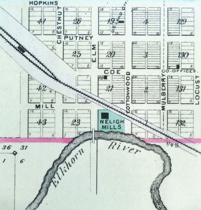
Marker detail: Early 1880s Plat Map
| 1 ► Nebraska, Antelope County, Neligh — Water Power at the Neligh Mill — |
| 2 ► Nebraska, Boyd County, Lynch — 346 — Lewis and Clark Campsite — September 7, 1804 — |
| 3 ► Nebraska, Buffalo County, Ravenna — Pleasanton Branch Union Pacific Railroad — |
| 4 ► Nebraska, Buffalo County, Ravenna — 361 — Post South Loup Fork — "Fort Banishment" — |
| 5 ► Nebraska, Butler County, David City — 252 — Shinn's Ferry — |
| 6 ► Nebraska, Cedar County, Crofton — 167 — Historic Missouri Valley — |
| 7 ► Nebraska, Cedar County, Crofton — The Great Missouri River — |
| 8 ► Nebraska, Chase County, Champion — 43 — Champion Water-Powered Mill — |
| 9 ► Nebraska, Dakota County, Jackson — 343 — Lewis and Clark Campsite — August 21, 1804 — Lewis and Clark Trail — |
| 10 ► Nebraska, Dakota County, Jackson — 034 — St. John's — 1856 — |
| 11 ► Nebraska, Deuel County, Big Springs — Keith County Nebraska — |
| 12 ► Nebraska, Deuel County, Big Springs — The Big Spring — |
| 13 ► Nebraska, Dixon County, Maskell — Mulberry Bend Scenic Overlook — |
| 14 ► Nebraska, Dixon County, Maskell — The Great Missouri River — |
| 15 ► Nebraska, Dixon County, Ponca — 270 — Ponca State Park — |
| 16 ► Nebraska, Douglas County, Florence, North Omaha — 130 — Mormon Pioneer Memorial Bridge — Reported missing |
| 17 ► Nebraska, Douglas County, Omaha, Downtown — Westwardly by the Waters — Albert Gallatin letter to Thomas Jefferson, April 13, 1803 — |
| 18 ► Nebraska, Douglas County, Omaha, Downtown — A River of Change — |
| 19 ► Nebraska, Douglas County, Omaha, Downtown — A River of Hope — |
| 20 ► Nebraska, Douglas County, Omaha, Downtown — Missouri River Flood — June 2011 - September 2011 — Matthew Placzek's Labor Monument Became the Symbol of the 2011 Flood. — |
| 21 ► Nebraska, Douglas County, Omaha, North Omaha — William Davis Brown — 1813 - 1868 — |
| 22 ► Nebraska, Dundy County, Benkelman — 470 — Nature's Gift: The Highway 34 Springs — |
| 23 ► Nebraska, Frontier County, Stockville — 84 — Frontier County Stockville — |
| 24 ► Nebraska, Furnas County, Oxford — 39 — The Republican River Flood Of 1935 — |
| 25 ► Nebraska, Gage County, Beatrice — River Town Development — |
| 26 ► Nebraska, Gage County, Beatrice — War Efforts at Home — We Answered the Call — 1861 - Today — |
| 27 ► Nebraska, Garfield County, Burwell — 188 — Garfield County — |
| 28 ► Nebraska, Garfield County, Burwell — 307 — The Calamus Valley — |
| 29 ► Nebraska, Garfield County, Burwell — 326 — The North Loup Project — |
| 30 ► Nebraska, Hall County, Grand Island — 172 — Grand Island — |
| 31 ► Nebraska, Hall County, Grand Island — 55 — La Grande Isle — |
| 32 ► Nebraska, Hall County, Grand Island — The Mormon Trail — |
| 33 ► Nebraska, Johnson County, Tecumseh — U.S.S. Maine — |
| 34 ► Nebraska, Kearney County, Kearney — 364 — The Great Platte River Road — |
| 35 ► Nebraska, Keith County, Ogallala — Chain – O – Lakes — |
| 36 ► Nebraska, Kimball County, Kimball — 487 — Maginnis Irrigation Flume — |
| 37 ► Nebraska, Knox County, Lindy — 345 — Lewis and Clark Campsite — September 2, 1804 — |
| 38 ► Nebraska, Knox County, Niobrara — The Land is Sacred to the Ponca People as is Water — |
| 39 ► Nebraska, Knox County, Niobrara — 101 — The Sage Brothers — |
| 40 ► Nebraska, Knox County, Niobrara — Water's Edge — Flow of life in the Riparian Habitat — |
| 41 ► Nebraska, Lincoln County, North Platte — Ditch Plow — |
| 42 ► Nebraska, Madison County, Meadow Grove — 069 — Meadow Grove — |
| 43 ► Nebraska, Morrill County, Bridgeport — 492 — Mud Springs — Nebraska Historical Marker — |
| 44 ► Nebraska, Nemaha County, Auburn — Legion Memorial Park Lily Pond — |
| 45 ► Nebraska, Nemaha County, Brownville — 64 — Brownville — |
| 46 ► Nebraska, Otoe County, Nebraska City — Barge / Keelboat (replica) — |
| 47 ► Nebraska, Otoe County, Nebraska City — The Missouri River — |
| 48 ► Nebraska, Platte County, Columbus — 424 — Andrew Jackson Higgins — (1886-1952) — |
| 49 ► Nebraska, Platte County, Columbus — 521 — Columbus Powerhouse — |
| 50 ► Nebraska, Platte County, Columbus — Commemorating Loup Fork Ferry — 1856 -1939 — |
| 51 ► Nebraska, Platte County, Columbus — The Columbus Quincentenary Belltower — |
| 52 ► Nebraska, Platte County, Columbus — The Road to Zion — |
| 53 ► Nebraska, Platte County, Duncan — 127 — Duncan — 1871 - 1971 — |
| 54 ► Nebraska, Red Willow County, McCook — Harry D. Strunk — 1892-1960 — |
| 55 ► Nebraska, Saunders County, Ashland — Platte River — |
| 56 ► Nebraska, Saunders County, Wahoo — U.S.S. Wahoo SS 238 — |
| 57 ► Nebraska, Scotts Bluff County, Gering — The Platte River Road — Boulder Fountain — |
| 58 ► Nebraska, Scotts Bluff County, Scottsbluff — Scott Memorial — |
| 59 ► Nebraska, Seward County, Milford — 180 — The Big Blue River — |
| 60 ► Nebraska, Seward County, Seward — Big Blue River, Seward — March 14, 2019 — |
| 61 ► Nebraska, Sherman County, Loup City — 322 — Dead Horse Creek — |
| 62 ► Nebraska, Washington County, Blair — 119 — DeSoto Townsite — |
| 63 ► Nebraska, Washington County, Blair — 137 — Steamboat Bertrand — |
| 64 ► Nebraska, Washington County, Blair — Up the Missouri — |
| 65 ► Nebraska, Wheeler County, Ericson — 536 — Pibel Lake Recreation Area — |