On Stage Harbor Road north of Inlet Road, on the right when traveling north.
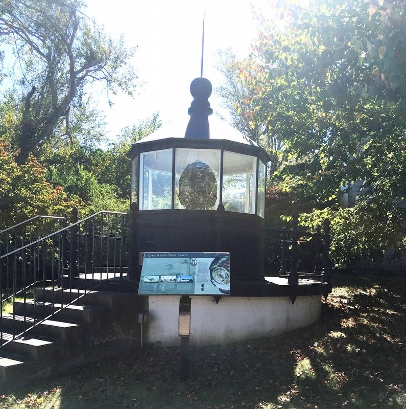
This Lighthouse lantern room dates back to 1887, when it was installed atop the south tower of Chatham’s twin lights, the third set to be built on the bluff known as James Head overlooking Chatham Harbor and the Atlantic at the elbow of Cape Cod. . . . — — Map (db m159757) HM
On East Commercial Street near Whit’s Lane, on the right when traveling east.
Timothy Daniels House, (Uncle Tim)
has been listed in the
Wellfleet Village
National Register
of Historic Places
by the United States
Department of the Interior.
Erected in 1824 — — Map (db m222832) HM
Near Art School Road, 1 mile west of Tyringham Road.
The Bidwell House,
built c. 1750,
has been placed on the
National Register
of Historic Places
by the United States
Department of the Interior — — Map (db m240850) HM
On Main Street (U.S. 7) east of South Street, on the right when traveling east.
has been included in the
National Regist[er] of Historic Places
as part of the
Main Street Historic District
Stockbridge, Massachusetts
The original home of 7 Arts Antiques and Gift Shop
In special . . . — — Map (db m230817) HM
On Pleasant Street at Market Street, on the left when traveling north on Pleasant Street.
In 1839 this Greek Revival building opened its doors to the public, not as the library it is today, but as New Bedford's town hall. When the growing town reached city size in 1847 the granite building became City Hall. Vendors sold produce and meats . . . — — Map (db m198215) HM
On Washington Street at Town House Square, on the left when traveling north on Washington Street.
Honored by being designated to the National Register of Historic Landmarks Built by the citizens of Marblehead as the center for their town government, it is a rare example of a public building in continual use since colonial days. Its history . . . — — Map (db m218893) HM
On Mall Street just south of Bridge Street, on the right when traveling north.
Built
1824
Peter Edgerly
Truckman & Trader
& his wife
Vashti "Vesta" C. Boynton
The Edgerly Family Home
1824 - 1833
Timothy Brooks III — Grocer
Asa Brooks, Jr. — Hardware
Luke Brooks, Jr. — . . . — — Map (db m186231) HM
On Summer Street at Essex Street, on the left when traveling north on Summer Street.
On the northwest corner of Essex and North Streets sits the Jonathan Corwin House ("Witch House") (1642-1675), a high style First Period house built for a late 17th c. merchant who served as a judge for the 1692 Salem Witch Trials. Nearby at 9 . . . — — Map (db m161190) HM
On Summer Street at Essex Street, on the left when traveling north on Summer Street.
Step Back In Time You stand on the threshold of possibly the finest collection of pre-twentieth century houses in America. A one-mile, 45-minute walking tour winds through the district bearing the name of one particularly famous architect and . . . — — Map (db m161193) HM
On Old Main Street south of Main Street, on the right when traveling north.
Museum admission tickets available at the Visitor Center.
• Built in 1824, by Asa Stebbins for his son, Asa, Jr.
• Gilded fanlight details over the front door became popular in the early 19th century.
• Connecticut Valley Furniture . . . — — Map (db m230686) HM
On Old Main Street south of Memorial Street, on the right when traveling north.
Museum admission tickets available at the Visitor Center.
• Built 1747.
• First painted blue in 1802.
• Interior furnishings illustrate change through time, 1725 to 1850. — — Map (db m230749) HM
On Front Street east of Center Street, on the right when traveling east.
This municipal government building, designed by Charles E. Parker, noted Boston architect, is patterned in architectural design after the famous Palazzo Vecchio in Florence, Italy. The unique tower is 147 feet high. Construction work started in 1870 . . . — — Map (db m198113) HM
On Main Street just east of Crossett Lane, on the right when traveling west.
Now known as Crossett Lane, these three buildings were constructed as separate structures. The three-story Queen Anne style block was erected by Gerard Burbach, who ran the adjacent United States Hotel for many years. It may have served as an annex . . . — — Map (db m158497) HM
On East Columbus Avenue just east of Pynchon Street, on the left when traveling west.
Now used for municipal offices, this limestone structure originally housed the District Court for Springfield and its surrounding towns. The first known district court was established in 1823. This location was selected for its proximity to the . . . — — Map (db m158396) HM
On Bridge Street at Stearns Square, on the left when traveling south on Bridge Street.
Constructed on a site formerly occupied by Scott's Laundry, this building was originally owned by the Morgan Realty Company, a development arm of the nearby Morgan Envelope Company, one of the City's largest industries. The two-story structure . . . — — Map (db m158579) HM
On Taylor Street just south of Kaynor Street, on the left when traveling south.
The Springfield Steam Power Company was formed in 1881 by the Wason Car Manufacturing Company to supply power to company-owned blocks in the vicinity of Taylor and Lyman Streets. Work was soon begun on this three-story building which was first . . . — — Map (db m158399) HM
The Springfield Armory was built in 1895
for the Massachusetts Volunteer Militia.
The building was designed by architects
Robert Wait and Amos Cutter from
Boston, who were responsible for many
county courthouses and state buildings in
Eastern . . . — — Map (db m127593) HM
On Stockbridge Street north of Main Street, on the right when traveling north.
In 1839, Elam Stockbridge laid out this street and later constructed a series of brick buildings. This structure is the sole survivor of that row which housed both stores and residences. From 1913 to 1973, the Guenther and Handel Company, a . . . — — Map (db m158699) HM
On Bridge Street just south of Barnes Street, on the right when traveling south.
This building replaced the Trinity Methodist Church which stood on the site from 1869 to 1922, when the congregation relocated to a more suburban section of the City. Samuel M. Green & Company designed the block, whose facade is a colorful . . . — — Map (db m158601) HM
In 1845, commanding Officer James W. Ripley and his family moved into a new residence, the large brick home you see in front of you. In addition to serving as the Armory leaders' residence, the home included servants and housekeepers for much of . . . — — Map (db m230757) HM
On Park Street at Hanover Street, on the right when traveling west on Park Street.
Only known solid brick salt box house of its period in the United States. At present, the only national historic site in the town of West Springfield – founded 1636. Preservation by Ramapogue Historical Society since 1903. — — Map (db m195172) HM
On River Drive (Massachusetts Route 47) 0.3 miles north of Huntington Road, on the left when traveling north.
Preservation Works!
The Porter-Phelps-Huntington Historic House Museum
This property which is listed in the state register of places, has received a matching grant from the Massachusetts Historical Commission, Secretary of the Commonwealth William . . . — — Map (db m194755) HM
On Main Street (Massachusetts Route 9/10) east of Masonic Street, on the right when traveling west.
This building is the remaining portion of the old
Draper Hotel
The first inn on this site was built by Asabel Pomeroy in 1792. Purchased by Oliver Warner in 1821 it became the Warner House, a celebrated stop on the Boston and Albany . . . — — Map (db m230495) HM
On Prospect Street north of Trumbull Road, on the left when traveling north.
(Private Residence, Not Open to the Public). The original structure on this site was built by Rev. The Manse as it appeared in the 1930s: included most of the land on the southeasterly side of Round Hill. Stoddard was called to Northampton in 1669 . . . — — Map (db m194971) HM
Built by the Province of The Massachusetts Bay in New England, in 1763
Named in honor of Thomas Hollis of London, Merchant, and other members of the same family, constant and generous benefactors of Harvard College from 1719 to 1804
. . . — — Map (db m109037) HM
Has been designated a Registered National Historic Landmark Under the provisions of the Historic Sites Act of August 21, 1935 This site possesses exceptional value in commemorating and illustrating the history of the United States U. S. . . . — — Map (db m41905) HM
On Lexington Road, on the left when traveling west.
Built in 1747 Kept by Amos Wright in 1775 --------------- Here met the Committees of the Provincial Congress on the eve of the Revolution while the larger body sat in a Meeting House close by. --------------- Headquarters of the Minutemen in the . . . — — Map (db m18525) HM
On Belknap Street at Grove Street, on the right when traveling east on Belknap Street.
Built in 1693 by Jeremiah Pike. He and his descendants were town and militia officers, yeomen and makers of spinning wheels, in the colonial period. This house has been occupied by the same family for eight generations. — — Map (db m48805) HM
On Bedford Street at Massachusetts Ave (Massachusetts Route 4), on the right when traveling north on Bedford Street.
has been designated a Registered National Historic Landmark Under the provisions of the Historic Sites Act of August 21, 1935 this site possesses exceptional value in commemorating or illustrating the history of the United States U.S. Department . . . — — Map (db m18457) HM
On Bedford Street (Massachusetts Route 225) at Massachusetts Ave (Massachusetts Route 4), on the right when traveling north on Bedford Street.
In 1714, Lexington selectmen gave John Muzzey permission to keep a “Publique House of Entertainment.” On Sundays townspeople came here for a hot flip and a warm fire after sitting for hours in the unheated church. John Buckman owned . . . — — Map (db m18482) HM
On Hancock Street, on the left when traveling north.
has been designated a Registered National Historic Landmark Under the provisions of the Historic Sites Act of August 21, 1935 this site possesses exceptional value in commemorating or illustrating the history of the United States U.S. Department . . . — — Map (db m48421) HM
On Hancock Street, on the left when traveling north.
The Hancock – Clarke House - Preserved from destruction in 1890 - stands as a memorial to Rev. Carleton A. Staples through whose personal efforts the building was saved and moved to this spot Instrumental in forming the Lexington . . . — — Map (db m19577) HM
On N Great Road (Massachusetts Route 2A), on the right when traveling west.
Minute Man National Historical Park was the starting place of the American Revolution; here the resolve of citizens willing to risk their lives for the ideals of liberty and self-determination was instrumental in the formation of the American . . . — — Map (db m191815) HM
Thomas Nelson Sr. emigrated from England and acquired, through purchase, the land along this road both east and west of here. On his death, the land was split between his two sons and daughter. Thomas Jr. lived here, Josiah lived to the west and . . . — — Map (db m18256) HM
On April 19, 1775, the house before you was the home of Jacob and Esther Whittemore and their four children. Although they were not involved in the battle, local tradition tells that a British soldier was shot and killed in front of the blacksmith . . . — — Map (db m18246) HM
On Merrimack Street at Palmer Street, on the left when traveling west on Merrimack Street.
Before suburban shopping malls began springing up in the mid-20th century, downtown anchor department stores like the Bon Marche sold almost every product a family needed. This store consisted of four interconnected buildings built in various . . . — — Map (db m117870) HM
On Kirk Street at Paige Street, on the right when traveling north on Kirk Street.
These three Greek Revival style town houses were among several private residences built along Kirk Street in the 1840s and 1850s for a growing middle class that was being attracted to Lowell. Named from right to left for their earliest known . . . — — Map (db m117801) HM
On Palmer Street at Middle Street, on the left when traveling north on Palmer Street.
Lowell's main fire station burned down in 1888 and although centrally located, was difficult to access on Middle Street. Palmer Street was cut through between Market and Merrimack Streets in 1889, improving access, and this new firehouse was built . . . — — Map (db m117893) HM
On Merrimack Street at John Street, on the right when traveling west on Merrimack Street.
One of several large department stores historically downtown, Cherry and Webb was located here since 1889 and in 1924, extensively reconstructed the building in early Art Deco style with polychromatic terra cotta. This building actually . . . — — Map (db m117859) HM
On Merrimack Street at John Street, on the right when traveling east on Merrimack Street.
Originally home to Wyman's Church that occupied a tall upper story over ground floor shops, the building was remodeled and converted to commercial use in 1879. Built by William Wyman, a local eccentric prone to ranting in church and at political . . . — — Map (db m117865) HM
On Middle Street west of Central Street, on the left when traveling west.
Middle Street was first developed in the 1830s and 1840s as a residential street, then largely redeveloped in the 1880s and 1890s with four and five story commercial and light-industrial buildings like this one. Originally known as the Burke . . . — — Map (db m117885) HM
On Market Street at Palmer Street, on the right when traveling west on Market Street.
This Italianate style building along with one to the rear on Middle Street was home to one of Lowell's largest patent medicine companies, J.C. Ayer & Company. A major Lowell industry, patent medicine companies like Ayer served national markets and . . . — — Map (db m117899) HM
On Shattuck Street at Middle Street, on the left when traveling south on Shattuck Street.
Established in 1849, the Lowell Gas Light Company supplied piped coal gas that lit the city's mills, businesses, and street lamps. Designed in the more contemporary and elegant Italianate style, the building contrasted with earlier Federal and . . . — — Map (db m117790) HM
On Shattuck Street at Middle Street, on the left when traveling south on Shattuck Street.
The Lowell Institution for Savings was founded in 1829, providing a savings bank for the early "mill girls." Greek Revival in style, it housed the bank until its closure in 1992. Other tenants shared the building over the years including artists, . . . — — Map (db m117779) HM
On Palmer Street at Middle Street, on the left when traveling south on Palmer Street.
When Palmer Street was created in 1889, new lots along the street were quickly built upon including this corner building, designed in the Queen Anne style popular for Lowell commercial buildings in the 1880s and 1890s. Originally five stories in . . . — — Map (db m117884) HM
On Merrimack Street at Palmer Street, on the right when traveling east on Merrimack Street.
Constructed after Palmer Street was cut through between Merrimack and Market streets in 1889, this building was originally home to a bank with private offices upstairs. Renaissance Revival in style, the building is notable for the delicate metal . . . — — Map (db m117872) HM
On Merrimack Street at Shattuck Street, on the right when traveling east on Merrimack Street.
Lowell's Greek Revival style "Town House" originally had a large meeting hall upstairs. Town meetings ended in 1836 when Lowell became a city but the meeting hall continued in public use including a speech by Illinois Congressman Abraham Lincoln . . . — — Map (db m117777) HM
On Middle Street west of Central Street, on the right when traveling west.
Middle Street was first developed in the 1830s and 1840s as a residential street, then largely redeveloped in the 1880s and 1890s with four and five story commercial and light-industrial buildings like this one. Originally known as the Parker . . . — — Map (db m117889) HM
On Middle Street west of Central Street, on the left when traveling west.
Middle Street's smaller residential buildings built in the 1830s and 1840s were rapidly replaced by four and five story commercial and light-industrial buildings like this one during the 1880s and 1890s. Wholesale grocers Simpson and Rowland . . . — — Map (db m117888) HM
On Shattuck Street south of Middle Street, on the right when traveling south.
Built in 1886 for Sewall G. Mack, foundry owner and former mayor of Lowell, this store was the headquarters for an extensive ironworks business. The Mack firm sold stoves, ranges and furnaces; and manufactured galvanized iron architectural . . . — — Map (db m117764) HM
On Paige Street east of Kirk Street, on the right when traveling east.
This building began its life as Lowell Primary School No. 3 in 1845 and the first floor dates to that time. By the 1890s it had been acquired by William Parker, a bobbin manufacturer who was also president of the First National Bank. Although . . . — — Map (db m117812) HM
On Merrimack Street at Shattuck Street, on the right when traveling east on Merrimack Street.
Greek Revival in style with a mansard roof added after an 1865 fire, this building housed a typical main street hardware store for over 100 years and originally contained a public meeting hall upstairs. One of many locations for lectures and . . . — — Map (db m117776) HM
On Kirk Street at Lee Street, on the right when traveling north on Kirk Street.
These Greek Revival style town houses were among several private residences built along Kirk Street in the 1840s and 1850s for a growing middle class being attracted to Lowell. They are named from left to right for their earliest known occupants: . . . — — Map (db m117793) HM
On Riverside Ave at Rockwell Ave, on the right when traveling west on Riverside Ave.
Known for many years as the Cradock House because it was thought to have been built in 1634 for Matthew Cradock, the construction of the house is now attributed to Peter Tufts. Although the exact date of its origin is obscure, it is known to . . . — — Map (db m55620) HM
On Main Street at Converse Place, on the left when traveling south on Main Street.
Built in 1640 by Edward Converse, who led the party sent out by Charlestown to explore "Waterfield." Selectman twenty-four years, deacon nineteen years, arrested in 1662 for speaking disrespectfully of the King's letter. — — Map (db m48831) HM
On Mendon Street (Massachusetts Route 140) at Thayer Road, on the left when traveling east on Mendon Street.
Lyndon F. Murray Memorial Building Fire Station # 1 On December 22, 1930, this building was dedicated as a Municipal Building and Fire Station. It was designated as Fire Station #1. The first floor had a two-bay fire station, a small assembly room . . . — — Map (db m195709) HM
Near Newton Street at St. Paul's Avenue, on the right when traveling west.
One of the most magnificent surviving carriage houses in New England, the Anderson Carriage House was designed by Edmund Wheelwright, former city architect of Boston, for the summer estate of William Fletcher Weld II. Its design was inspired by the . . . — — Map (db m33022) HM
Near Newton Street at St. Paul's Avenue, on the right when traveling west.
Putterham School
c. 1768
The only remaining eighteenth-century schoolhouse in Brookline, Putterham School was built to serve the farm families of South Brookline. Classes were held at this one-room schoolhouse for more than 150 years. Around . . . — — Map (db m33020) HM
On Pleasant Street, on the left when traveling north.
Founded April 25, 1874
"For promoting the boating interests of the town"
Incorporated October 29th 1874
First boathouse built on Ames Street site in 1875.
Destroyed by lightning in July 1882.
Second boathouse built on this site in . . . — — Map (db m56100) HM
Near Hancock Street at Coddington Street, on the right when traveling south.
James R. McIntyre, AB. M.A. J.D.
1930-1984
This Building Dedicated in his Honor
Quincy Native, Scholar, Officer of Marines, Korean War, Attorney, Statesman and Gentleman.
Served his city and state with honor and distinction as councillor, . . . — — Map (db m234476) HM
On Adams Street, on the right when traveling west.
National Park Service U.S. Department of the Interior [ Back of marker ] “It is but the farm of a Patriot” • • • • • John Adams, 1788 — — Map (db m40652) HM
Near Hancock Street at Coddington Street, on the right when traveling south.
Built in 1844 when Quincy granite was at the height of its popularity as a monumental architectural material. The residents of Quincy intended their Town Hall to be a testament to the quality of their granite industry. Solomon Willard, architect of . . . — — Map (db m234477) HM
First Meeting House raised shortly after the gathering of the church in 1635 within a palisade.
First Burying Ground, First School House built prior to 1661.
Fort erected in 1676.
These landmarks were located upon this hill, the . . . — — Map (db m2850) HM
On Carver Street, on the right when traveling west.
Built in 1832 by Capt. James Bartlett Master of the Barque HANNAH in the West Indies Trade. This is the third house on this site which was originally the land of Samuel Fuller of the Mayflower. Captain Bartlett’s daughter married Isaac Brewster and . . . — — Map (db m107438) HM
Near School Street, on the left when traveling north.
The Massachusetts Society of the Sons of the American Revolution came to Plymouth on October 12, 1920 to dedicate this replica of the old Powder House. The original structure had been erected in Plymouth in 1779 and removed about 1880. The Society . . . — — Map (db m107466) HM
On Town Square at Market Street, on the right when traveling east on Town Square.
On this site until 1749 stood
The Government House
Of the old Colony
In that year this building was erected
By the county for a court house
It was used jointly by the county
And the town until 1820
And then became the property of . . . — — Map (db m187343) HM
On First Parish Road at Center Park Drive, on the right when traveling west on First Parish Road.
This historic tower – a gift to the town in 1902 from Thomas W. Lawson, “The Copper King” has an over all height of 153 feet and encloses a water tank, a clock room and a bell room complete with tuned bells upon which melodies are played on . . . — — Map (db m218926) HM
On Country Way just north of the Greenbush Rotary, on the right when traveling north.
In 1640 Isaac Stedman dammed up First Herring Brook and beside the pond thus formed, constructed the first water driven grist mill in the old colony. The mill owned and operated by the Stockbridge and Clapp families until 1922 was made famous in . . . — — Map (db m24546) HM
On Charles Street south of Pinckney Street, on the right when traveling south.
94 Charles Street Building Built 1860 Has been placed on the National Register of Historic Places in 1999 by the United States Department of the Interior — — Map (db m176394) HM
On Warren Street at Dexter Row, on the right when traveling north on Warren Street.
When it was constructed in 1876, this bank was the most important commercial building in Charlestown. It was designed by Moffette and Tolman in the High Victorian Gothic Style. The building also housed Charlestown’s Masonic Lodge on its top three . . . — — Map (db m218891) HM
On Beacon Street at Tremont Street on Beacon Street.
The Walk to the Sea encompasses four centuries
of Boston history. Beginning at the State House on
Beacon Hill, overlooking Boston's ancient Common,
the Walk passes among historic landmarks and
skyscrapers. The Walk crosses ground that, . . . — — Map (db m144148) HM
On Washington Street at Milk Street, on the right when traveling north on Washington Street.
has been designated a Registered National Historic Landmark Under the provisions of the Historic Sites Act of August 21, 1935 this site possesses exceptional value in commemorating or illustrating the history of the United States U.S. Department . . . — — Map (db m18087) HM
On State Street at Congress Street, on the right when traveling west on State Street.
The Old State House, Boston’s oldest public building, was built in 1713 as the seat of British colonial government. Here the Royal Governor and the Massachusetts Assembly debated the Stamp Acts and the Writs of Assistance. The Declaration of . . . — — Map (db m18096) HM
On Devonshire St. at State St., on the right when traveling south on Devonshire St..
“ . . . there the child Independence was born.” Built in 1713, the Old State House was the seat of government of the Province of Massachusetts Bay. In this building the Royal Governors, the Colonial Courts, and the . . . — — Map (db m18689) HM
This building served as Boston's City Hall from 1865 until 1969, when it was renovated for use as an office building. Boston's Old City Hall is one of the first examples of adaptive reuse. In the 1960's the concept of recycling out-dated public . . . — — Map (db m76635) HM
1630-1673
Zacheus Bosworth, Captain Thomas Clarke and Lieutenant Richard Cooke dwelt here on School House Lane
1704
John Mico built a mansion on this site which was occupied in turn by Colonel Jacob Wendall, Governor Moses Gill and . . . — — Map (db m21664) HM
On School Street at Province Street, on the right when traveling east on School Street.
One of Boston’s luxury hotels, opened by innovative hosteller Harvey Parker, the Parker House has been operating on this site since 1856. Parker introduced the European Plan, started the practice of scrod, the fresh white fish catch of the day. The . . . — — Map (db m18510) HM
On Lewis Street at East Pier Drive, on the right when traveling south on Lewis Street.
Much has changed along Boston's waterfront and in the harbor since this image was drawn in 1848. Wharves were constructed and mud flats filled, creating more land. Buildings went up; others were torn down.
What else is different? Which . . . — — Map (db m215790) HM
On Marshall Street at Creek Square, on the right when traveling north on Marshall Street.
The Ebenezer Hancock House, built in 1767, is the only remaining house in Boston associated with John Hancock. He owned the house but it was lived in by his brother Ebenezer, who was Deputy Paymaster General of the Continental Army. This is one . . . — — Map (db m18092) HM
138 entries matched your criteria. The first 100 are listed above. The final 38 ⊳