Near East Valencia Road 0.3 miles west of South Wilmot Road.
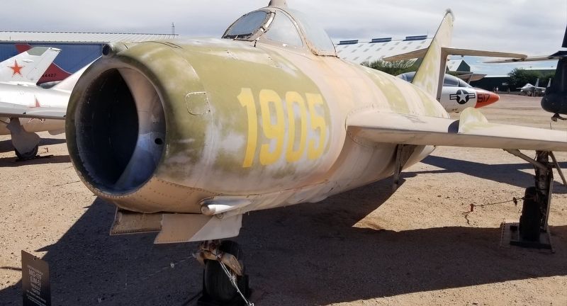
Mikoyan-Gurevich
MiG-17F (LIM-5)
Fresco-C Fighter
1950-Present Limited Service
On Loan From the National Museum Of the United States Air Force — — Map (db m189548) HM
Near East Valencia Road 0.3 miles west of South Wilmot Road.
Mikoyan-Gurevich MiG-17PF (LIM-6MR) Fresco-D Fighter/Reconnaissance 1955-1987
On Loan From the National Museum of the United States Air Force — — Map (db m189549) HM
Near East Valencia Road 0.3 miles west of South Wilmot Road.
Sikorsky VH-34C Choctaw 1955-1970
This aircraft served in the Presidential Fleet On loan from the National Naval Aviation Museum — — Map (db m185805) HM
Near East Valencia Road 0.3 miles east of South Wilmot Road.
Current Markings: National Aeronautics and Space Administration
The Thiokol Space Shuttle Solid Rocket Booster is the first solid fuel rocket used to propel a manned space vehicle into orbit. It is also the most powerful rocket motor ever . . . — — Map (db m185617) HM
On East University Boulevard 0.2 miles west of North Campbell Avenue, on the right when traveling west.
This seedling was grown from the very seeds that journeyed to the moon and back on board Apollo 14. It symbolizes the major role forests played in developing our American Heritage and the vital role forests have in our future.
This planting made . . . — — Map (db m83012) HM
On South 4th Avenue south of West 1st Street, on the right when traveling north.
On October 25, 1911, pioneer aviator Robert Grant Fowler touched down on this site, becoming the first person to land an airplane in Arizona under its own power. A native Californian, he had departed Los Angles October 19, and completed aviation . . . — — Map (db m29018) HM
A bronze patee on which is superimposed a four-bladed propeller, the Distinguished Flying Cross is awarded to any person who, while serving in any capacity with the Armed Forces of the United States distinguishes himself or herself by heroism or . . . — — Map (db m90865) HM
Near South Main Street north of Southeast 2nd Street, on the left when traveling south.
In 1936. Thaden won the Bendix Trophy Race in the first year women were allowed access to compete against men. She set a new world record of 14 hours, 55 minutes from New York City to Los Angeles, California. In her astonishing victory, she flew . . . — — Map (db m236883) HM
On Hudson Road (U.S. 62) at Cass Hough Drive, on the left when traveling north on Hudson Road.
USAF Century Series aircraft flown by active interceptor squadrons, the Air Defense Command, and the Air National Guard from 1959 - 1983.
The Voodoo is well known for its NATO role as a nuclear deterrent during the Cold War.
The RF-101 . . . — — Map (db m62520) HM
On North Lakeshore Drive 0.8 miles south of Club Drive, on the right when traveling south.
In April 1923 Lindbergh, then an unknown 21-year-old mail pilot, experienced engine trouble and landed his airplane on the now-abandoned golf course behind this site of the old Lake Village County Club. He remained in Lake Village overnight. During . . . — — Map (db m89779) HM
On Central Avenue (State Highway 7) at Spring Street, on the right when traveling north on Central Avenue.
Enlisted in 1917 to be a WWI pilot in Europe, at a time when planes were new and dangerous • First assigned to the RAF in England in 1918 • Became an “Ace” pilot with 12 confirmed kills, 3rd most • Awarded British / US Distinguished Service & . . . — — Map (db m265099) HM
On Central Avenue (State Highway 7) at Spring Street, on the right when traveling north on Central Avenue.
M.I.T. Aeronautical Engineer • Formed McDonnell Aircraft Corp 1939 • Primary supplier of fighter jets to US Military and worldwide • Built first space Mercury Capsule for NASA • Served as first CEO of McDonnell Douglas Corp • Arkansas and National . . . — — Map (db m265092) HM
Near Greenwood Avenue at 5th Street, on the right when traveling east.
Dedicated to the memory of Lt. Paul James Riley United States Navy killed 4 June 1942 Battle of Midway awarded The Navy Cross and The Distinguished Flying Cross Greater love hath no man than this that a man lay down his life for . . . — — Map (db m264382) WM
On Spring Street at Central Avenue (State Highway 7), on the right when traveling west on Spring Street.
Highly decorated helicopter pilot — Vietnam • Created dramatically improved attack ability and life saving low level combat techniques • Three combat tours, three Silver and Bronze Stars, four Distinguished Flying Crosses, three Purple Hearts plus . . . — — Map (db m265256) HM
On Grant 51 (County Rd. 51) 2 miles east of Ark. Hwy. 35, on the right when traveling east.
2nd. Lt. George H. Davis
Dubuque. Ia. Pilot
2nd. Lt. Robt. V. Turchetto
Nutley, N. J. Co-Pilot
T/Sgt Peter K. Ikanovich
Bisbee, Ariz.
S/Sgt Arthur N. Potter
Sutton, Mass.
2nd Lt. Philip E. Niewolak
Dunkirk, N.Y., . . . — — Map (db m228715) HM WM
On Grant 51 ( County Rd. 51) 2 miles east of State Road 35, on the right when traveling east.
On March 12, 1943 a B-17 Flying Fortress exploded mid-air while trying to
land in the field on the West side of this road. The B-17 replica marks the site
where the Flying Fortress came to rest. Over the years the gray monument
marking the crash . . . — — Map (db m227739) HM WM
On Southwest 2nd Street just south of West Main Street (U.S. 412), on the left when traveling north.
A quiet night in 1964 was interrupted by the unusual sound of an airliner approaching Walnut Ridge Airport. Its arrival sparked enough interest that three local teens went to investigate, only to discover John, Paul, Ringo and George walking from . . . — — Map (db m170608) HM
On North Beacon Road 0.1 miles north of Custom, on the left when traveling north.
Honoring the men of the Arkansas National Guard Company A, 2nd Battalion stationed in Walnut Ridge, Arkansas for selfless service. — — Map (db m174006) WM
On Ramp Road north of Douglas Road, on the left when traveling north.
2nd LT John W Gillette III 11-15-42 •
CPL Donald H Bucklin 11-15-42 •
Cadet Charles E Thiede, 12-1-42 •
2ND LT Harry B House, 1-4-43 •
2nd LT Frank W Roberts, 1-29-43 •
2nd LT Arthur Krasne, 1-29-43 •
Cadet, William M Cosine Jr., . . . — — Map (db m175050) WM
On North Beacon Road (at milepost 0.5), 0.1 miles north of Custom, on the left when traveling north.
Engineer - Top Turret Gunner
B-17 Flying Fortress - WWII
On September 27, 1943 his aircraft the Elusive Elcy was attacked by enemy aircraft near Norden, Germany. A giant explosion severed the left wing. Sgt. Roberts and 9 other crew . . . — — Map (db m174047) HM WM
On Southwest 2nd Street 0.1 miles south of West Main Street (U.S. 412), on the right when traveling south.
Newell Mock had a love for photography and a camera always at the ready. He captured these black and white images on September 20, 1964 as the Beatles returned to Walnut Ridge Airport from their weekend vacation at Pigman's Ranch in Missouri. John . . . — — Map (db m170243) HM
After the United States of America was drawn into World War II, the U.S. Army Air Forces urgently needed pilots. On April 15, 1942, its Site Selection Board recommended this location for a Basic Flying School, one of only 26 nationwide. The War . . . — — Map (db m286433) HM
On East Front Street east of Hicks Street, on the right when traveling east.
The Army Aviation Commission in 1917 accepted these 960 acres from Lonoke citizens to establish an aviators school. Approximately 2,500 enlisted men and officers were stationed here from 1918 to 1919. A thousand planes, sometimes known as "flying . . . — — Map (db m218159) HM
On W Vine Street at S. 3rd Street, in the median on W Vine Street.
Before 1776 this area was inhabited by Indian Mound builders, bayous were the only drainage and there was no flood control, there was an immense forest that consisted mostly of hardwoods and cypress, in the early 1900's drainage districts began to . . . — — Map (db m212074) HM
On Memorial Drive at Chestnut Drive, on the right when traveling east on Memorial Drive.
To honor the memory of these brave men from the 97th Bombardment Wing at Blytheville Air Force Base who did not return after their B-52 aircraft was shot down over Hanoi, North Vietnam in December 1972
Col. Keith R. Heggen • Lt. Col. Donald . . . — — Map (db m24056) HM WM
On Porter Street east of Pecan Street, on the right when traveling east.
Jet aircraft began replacing propeller-powered planes in the late 1940s. Differences in handling resulted in a high accident rate among pilots unused to the new aircraft. Lockheed developed this plane, the T-33 Shooting Star, to help pilots make the . . . — — Map (db m108005) HM
The United States Army Air Forces opened Stuttgart Army Airfield (SAAF) in October 1942 for the purpose of advanced pilot and crew training in Waco CG-4A Hadrian gliders for WW2 European operations. The 2,682-acre airfield consisted of four . . . — — Map (db m289708) HM
On Veterans Circle 0.1 miles West Main Street, on the right.
Not all soldiers wear uniforms and carry rifles. Those civilian workers who went into the Titan II Missile complex near Searcy August 9, 1965, were dressed in work clothes, wore hard hats, carried hammers and paint brushes, but who's to say they . . . — — Map (db m184023) HM
On John Harden Drive 0 miles north of Vandenberg Drive when traveling west.
This C-130E was manufactured by Lockheed Aircraft, Marietta Georgia
in May 1963. It was delivered to the 1608th Air Transport Wing, located at
Charleston AFB, SC. It was transferred to the 316th Tactical Airlift Wing
in March 1967, located at . . . — — Map (db m224385) HM
On West Broadway Street (State Highway 90/115) at South Van Bibber Street, on the left when traveling west on West Broadway Street.
This meteor fell July 1859 in the Black River Bottoms of Randolph County. It was discovered by A.H. Keith. Donated by the Keith family March 16th in celebration of Arkansas' sesquicentennial. — — Map (db m171651) HM
On 6th Street (State Highway 255) south of Rogers Avenue, on the left when traveling south.
This tree was grown from a seed
that journeyed to the Moon and back
aboard Apollo 14 1971
Planted here on Arbor Day March 15
Bicentennial Year 1976 — — Map (db m92358) HM
On Highway 65 South (U.S. 65 S) 0.1 miles north of Sulphur Road, on the left when traveling north.
Near this site on September 18-19, 1980, an accidental explosion destroyed Missile Complex 374-7, which housed an Air Force Titan II intercontinental ballistic missile (ICBM). At 103 feet tall and with a 9-megaton nuclear warhead, the Titan II was . . . — — Map (db m311547) HM
On Ferry Point north of Oriskany Avenue, on the right when traveling south.
Five Decades of Operation
From the Second World War through the Korean and Vietnam wars, Naval Air Station (NAS) Alameda supported the Department of the Navy's defense mission, until operational closure in 1997. During this period numerous . . . — — Map (db m232568) HM
Early Bay Area Aviation
During the early 20th century, early Bay Area aviators faced the challenge of frequent fog and limited areas of flat, vacant land for aircraft takeoff and landing. The western portion of Alameda was identified as . . . — — Map (db m191944) HM
Historically Alameda was a peninsula, rich in
natural resources. Native peoples gathered food
and materials from bay salt marshes, abundant
oak forests, and nearby shorelines. From the
early 1800's the western tip of the peninsula
now known as . . . — — Map (db m157046) HM
The Douglas SBD Dauntless is a World
War II American naval scout plane and
dive bomber that was manufactured by
Douglas Aircraft from 1940 through 1944.
The SBD ("Scout Bomber Douglas") was
the United States Navy's main
carrier-based . . . — — Map (db m191861) HM
The Grumman F6F Hellcat is an
American carrier-based fighter aircraft of
World War II. It was the United States
Navy's dominant fighter in the second
half of the Pacific War. It's first flight was
26 June 1942. 12,275 planes were
produced . . . — — Map (db m191498) HM
The Grumman J2F Duck is an American
single-engine amphibious biplane. The
J2F's were designed in 1934 specifically
for the Coast Guard. The second model
in the series was the J2F 4-6. It was used
by each major branch of the U.S. armed
forces . . . — — Map (db m191521) HM
Pan American World Airways fabled China Clipper (Martin M/130 Flying Boat) left Alameda Marina on November 22, 1935. Under the command of Captain Edwin G. Musick. The flight would reach Manila via Honolulu, Midway, Wake, and Guam. The inauguration . . . — — Map (db m100565) HM
On Ferry Point north of West Oriskany Avenue, on the right when traveling south.
Patrol, Rescue, and Transport Missions
The construction of the Seaplane Lagoon and two of the eventual five seaplane hangars prior to building landplane hangars and the airfield, confirms the high importance of seaplanes and flying boats to . . . — — Map (db m232538) HM
The Vought A-7A Corsair II is an
American carrier borne and land based
subsonic single-seat tactical fighter. The
A-7 was developed during the early
1960's as a replaccement for the Douglas
A-4 Skyhawk. Its design derived from the
Vought F-8 . . . — — Map (db m191518) HM
On Ferry Point north of West Oriskany Avenue, on the left when traveling north.
NAS Alameda
Encouraged by Alameda's trio of existing aviation facilities, Congress appropriated funding to build Naval Air Station (NAS) Alameda in 1937, after decades of urging for an air station by the Navy and local supporters. The air . . . — — Map (db m232301) HM
On Terminal Circle, on the left when traveling west.
Eight miles southwest of this location, in the Spring of 1904, Charles Tolliver built an airship.
With an aluminum superstructure covered with 6,000 yards of rongee silk, the craft was to be 250 feet long, 40 feet wide and 44 feet high. Four . . . — — Map (db m19968) HM
"There's more to life than being a passenger"
Amelia Mary Earhart
Just 600 feet south of where you now stand was Oakland's old North Field runway where aviatrix
Amelia Earhart made history. On January 11, 1935, Earhart flew . . . — — Map (db m179015) HM
On Earhart Road, on the left when traveling north.
To the memory of
the Australian aviators
Sir Charles Kingsford-Smith
and Captain Charles T. P. Ulm.
This plaque is dedicated by the Board of Port Commissioners of the City of Oakland as a permanent tribute to the courage and foresight of . . . — — Map (db m71201) HM
On Earhart Road, on the left when traveling north.
On Tuesday, June 28, 1927, at 7:08 a.m. Lieutenant Lester J. Maitland and Lieutenant Albert F. Hegenberger, Air Corps United States Army, took off from Oakland Municipal Airport on the first successful non-stop trans-Pacific air flight arriving at . . . — — Map (db m71200) HM
Near Earhart Road south of Langley Street, on the right when traveling north.
This is a VTOL (vertical takeoff and landing) aircraft. It was developed by the British company Hawker Siddeley as a single seat attack and reconnaissance aircraft.
A number have been built under license by McDonnell Douglas in the U.S.
Engine . . . — — Map (db m223775) HM
The Story of the Heroes of Flight 93
The events of September 11th, 2001 are forever etched into the hearts of the family members and loved ones of those who died, the Nation and the world. The United States experienced the worst incident of . . . — — Map (db m26392) HM WM
On Consolation Street at Main Street, on the right when traveling north on Consolation Street.
Here in Volcano in 1860, miner and amateur astronomer George Madeira built California's first astronomical observatory of record and operated it for two years. Using a three inch refractory telescope he studied sun and moon, stars and planets, and . . . — — Map (db m100583) HM
The City of Oroville
built the
Oroville Municipal Airport
in 1933 and it
proudly served as a
WW II Training Base
Mural circa 1942
Dedicated 1996 — — Map (db m61601) HM
A large flashing light atop this rotunda once guided airplanes flying through the night skies of the Bay Area. Originally held aloft on a 75-foot tower erected by Standard Oil in 1928, it served as a crucial route-finding aid in the days before . . . — — Map (db m93631) HM
Near Summit Road 11 miles north of Blackhawk Road, on the right when traveling north.
Mount Diablo has always been a guide and landmark to people far bellow, and so it became a natural location for many radio and transmission towers as well.
As early as 1928, the Standard Oil Company and U.S. Dept. of Commerce jointly . . . — — Map (db m103092) HM
On Los Gatos Creek Road 14 miles west of Derrick Avenue, on the right when traveling west.
On the morning of January 28, 1948, a plane went down
across the road from this memorial Killing 28 Bracero
workers, 3 crew members and an immigration officer.
The plane crash was observed by convicts from the
Fresno County Road . . . — — Map (db m310096) HM
On North Doolittle Drive 0.1 miles south of West Spaatz Avenue, on the left when traveling south. Reported missing.
Established October 23, 1946 as America's first aviation community. Through the efforts of Wm. and Doris Smilie, 130 acres of rolling "hog-wallow" and hardpan were transformed into a public use airport, with a sod runway, connecting taxi-way and . . . — — Map (db m290416) HM
On County Road G at Airport Road on County Road G.
The first operational air tanker was developed in Willows, by the Willows Flying Service in 1955, at the
request of the Fire Control Officer for the Mendocino National Forest. A Boeing Stearman 75 “Caydet” Agricultural
Aircraft was modified . . . — — Map (db m230783) HM
Near Leighton Lane 3.8 miles north of California Route 168.
The Millimeter Interferometer, built through the generous support
of the National Science Foundation.
May 4, 1985
Owens Valley Radio Observatory
California Institute of Technology — — Map (db m315890) HM
On Airport Road 0.7 miles north of East Line Street.
This plaque is dedicated to commemorate: Bishop Airport &
Robert F. Symons, local mountain pilot & “Dean of Sierra
Wave Soaring” (1910-1958).
Robert Symons’ early flight & cloud studies brought the
Air Force & UCLA to chart the . . . — — Map (db m288227) HM
On Airport Road 0.7 miles north of East Line Street.
Fifty years ago, the eastern edge of the Sierra Nevada was the site of intense atmospheric research to explore the cause and dynamics of the newly appreciated and powerful mountain wave phenomenon known locally as the Sierra Wave.
This . . . — — Map (db m156150) HM
On California Route 190 37 miles east of U.S. 395, on the left when traveling east.
Before
you is part of one of the largest military aircraft
training areas in the U.S. It has been used continuously since
the 1930s. Much of what is now the western portion of
Death Valley National Park was added under the condition
that . . . — — Map (db m194626) HM
Located on the hills in front of you, on the historic Tejon Ranch, the Arvin-Sierra Glider Port was the site for the West Coast Soaring Championships. Many of America’s famous glider pilots made record flights from here, soaring over the mountains . . . — — Map (db m156337) HM
On Twenty Mule Team Road at Boron Avenue, on the left when traveling west on Twenty Mule Team Road.
Florence Lowe “Pancho” Barnes was a pioneering aviator, rancher, and entrepreneur whose adventurous spirit left a lasting mark on aviation history in the United States. Born on July 22, 1901, in Pasadena, California, she grew up in a family well . . . — — Map (db m286047) HM
On Aerospace Highway (California Route 14), on the right when traveling south.
Florence Leontine Lowe was born July 29, 1901 in Pasadena. Through an arranged marriage in 1921, she became the wife of a minister, Rankin Barnes. She ended her relationship with him a few years after bearing a son, Billy.
Florence acquired the . . . — — Map (db m51666) HM
5621 entries matched your criteria. Entries 401 through 500 are listed above. ⊲ Previous 100 — Next 100 ⊳