Near Meadow Road Northeast, 0.1 miles west of Ellipse Road Northeast, on the left when traveling west.
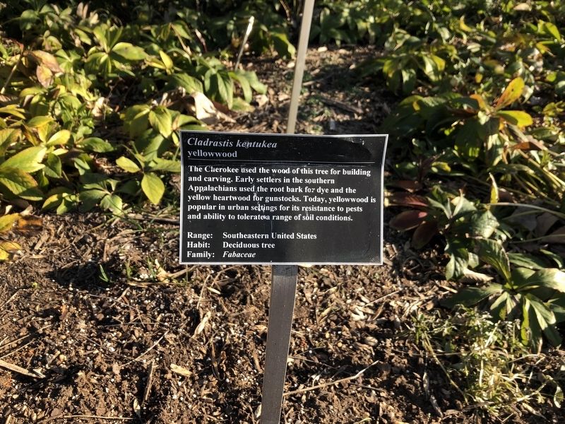
The Cherokee used the wood of this tree for building and carving. Early settlers in the southern Appalachians used the root bark for dye and the yellow heartwood for gunstocks. Today, yellowwood is popular in urban settings for its resistance to . . . — — Map (db m144694) HM
Near Elipse Road Northeast at Beechwood Road Northeast, on the left when traveling north.
These 22 Corinthian sandstone columns were among 24 that were part of the east portico of the United States Capitol. Architect Charles Bullfinch oversaw construction of the portico using a design handed down by his predecessors, William Thornton and . . . — — Map (db m918) HM
Near Elipse Road Northeast north of Beechwood Road Northeast, on the right when traveling south.
The presence of the National Capitol Columns on the knoll in this meadow was the inspiration of Ethel Shields Garrett, patron and friend of the National Arboretum. It was through her vision, courage, and determination for thirty years that these . . . — — Map (db m917) HM
On Eagle Nest Road Northeast north of Azalea Road Northeast, on the right when traveling north.
The sandstone base and capital are from a Corinthian column that once graced the east central portico of the United States Capitol. The columns were dismantled in 1958 to make way for the east front extension, where marble reproductions now stand. . . . — — Map (db m7621) HM
On 3rd Street Northeast at H Street Northeast, on the right when traveling north on 3rd Street Northeast.
The elegant Romanesque portion of the Senate Square condominium complex started life in 1874 as the Little Sisters of the Poor House for the Aged. St. Aloysius Church member Ellen Sherman, wife of Civil War General William Tecumseh Sherman, . . . — — Map (db m186806) HM
Near 14th Street Northeast at Quincy Street Northeast, on the right when traveling north.
Sacred to the memory of the servant of God
Aristides Leonori
Third Order of St. Francis.
Saintly Roman architect of this memorial church and monastery of the Holy Sepulcher, Wash. D.C.
Born - July 28, 1856
Died - July 30, 1938 . . . — — Map (db m208432) HM
Near 14th Street Northeast south of Quincy Street Northeast, on the right when traveling north.
Corinthian Capital Circa 2nd-3rd century AD. This capital, the top of a column, is from Jerusalem. Capitals of this type can be seen in Roman buildings constructed during the time of the Roman occupation of the Holy Land. Good examples can still . . . — — Map (db m111792) HM
On Monroe Street Northeast east of 12th Street Northeast, on the right when traveling east.
Dedicated in memory of the longest serving member of Engine Company 17, Wagon Driver Jackson H. Gerhart.
He was appointed on Feb. 3, 1963 and retired on Sept. 30, 1994. He succumbed to injuries sustained in the line of duty while operating . . . — — Map (db m111800) HM
On Columbus Circle Northeast at Delaware Avenue Northeast, on the right when traveling east on Columbus Circle Northeast.
Union Station
Architecture by
Daniel Burnham, 1908
Designed in the Beaux-Arts style, this was the world's largest train station when it opened - the station and terminal zone originally covered approximately 200 acres and included 75 . . . — — Map (db m8442) HM
On 11th Street Northeast south of C Street Northeast, on the left when traveling south.
Designed 1916
in Moorish Revival Style
Architect
William S. Plager
(1860-1946)
Photo: circa 1926
Goode Collection
Library of Congress
Redesigned 1941
in Art Deco Style
Architect
Mihran Mesrobian . . . — — Map (db m134068) HM
Near 1st Street Northeast south of Maryland Avenue Northeast.
General Plan for the Improvement of the U.S. Capitol Grounds by Frederick Law Olmstead, 1874
Following the extension of the Capitol in the 1850s-1860s, the grounds were enlarged in 1872. In 1874 Congress commissioned Frederick Law Olmstead . . . — — Map (db m27891) HM
On Benning Road Northeast at 21st Street Northeast, on the right when traveling west on Benning Road Northeast.
Langston Terrace Dwellings, opened in 1938, was the first federally funded public housing project in Washington and among the first in the nation. It honors John Mercer Langston (1829-1897), abolitionist, founder of Howard University Law School, and . . . — — Map (db m112792) HM
On Sheriff Road Northeast just east of 43rd Place Northeast, on the left when traveling west.
This quaint frame building has served several church congregations since its construction in 1908. The First Zion Baptist Church stayed for more than 60 years. Since 1993 members of Joshua's Temple First Born Church have worshiped within its . . . — — Map (db m130784) HM
On Jay Street Northeast at 49th Street Northeast, on the right when traveling east on Jay Street Northeast.
Largely ignored by city officials and isolated from downtown DC, Deanwood remained semi-rural until around World War II (1941-1945).
Lifelong residents who grew up in the 1930s and '40s remember outsiders telling them that they lived in . . . — — Map (db m130781) HM
On Hunt Place Northeast just east of 46th Street Northeast, on the right when traveling east.
Jacob Dodd (d. 1930) left the Government Printing Office in 1920 to join his brother Randolph (d. 1944) in the house-building business. Though they collaborated on at least 50 projects in Deanwood, they also worked individually, completing more . . . — — Map (db m187368) HM
On Hunt Place Northeast just west of 46th Street Northeast, on the right when traveling west.
Lewis Giles, Sr. (1894-1974) was an influential Washington architect who designed this Colonial Revival/craftsman style house in 1929. He lived here the rest of his life, and worked in his home office.
Giles graduated from Armstrong . . . — — Map (db m187369) HM
On 48th Street Northeast at Sheriff Road Northeast, on the right when traveling north on 48th Street Northeast.
Up the hill to your left are several signature handcrafted houses, Beginning in the late 1800s, Deanwood attracted skilled black migrants, who freely passed on their know-how.
In the 1920s Jacob and Randolph Dodd built about 50 structures . . . — — Map (db m153319) HM
Near Lincoln Road Northeast near Bryant Street Northeast, on the right when traveling south.
The Glenwood Cemetery Chapel
designed by renowned architect Glenn Brown in 1892, has been designated a District of Columbia Historic Landmark and is also inventoried on the National Register of Historic Places. — — Map (db m129029) HM
On Lincoln Circle Northeast north of Florida Avenue Northeast.
Chapel Hall
Gallaudet College has been designated a
Registered National Historic Landmark
under the provisions of the Historic Sites Act of August 21, 1935, this site possesses exceptional value in commemorating or illustrating the . . . — — Map (db m40459) HM
On Fitch Place Northeast just east of 49th Place Northeast, on the right when traveling west.
Howard Dilworth Woodson (1877-1962), a Pittsburgh native, arrived in Washington in 1907 to work as a structural engineer in the Office of the Supervising Architect, U.S. Department of the Treasury. One of the first African American professionals . . . — — Map (db m187367) HM
On Minnesota Avenue Northeast at Hayes Street Northeast, on the right when traveling north on Minnesota Avenue Northeast.
If you had stood here 100 years ago, you might have heard the cheering crowds and thundering hoofbeats of Benning Racetrack just across the tracks to your right.
Beginning in 1890, Benning was the best-equipped race course in Washington. . . . — — Map (db m130786) HM
On Kenilworth Terrace Northeast at Jay Street Northeast, on the right when traveling south on Kenilworth Terrace Northeast.
Mayfair Mansions, completed in 1946 on the site of the old Benning Race Track, was one of the city's earliest garden apartment developments. The 500-unit, first-class complex was designed by Howard University Professor of Architecture Albert I. . . . — — Map (db m136186) HM
On 17th Street Northwest south of V Street Northwest, on the right when traveling south.
Calvin T.S. Brent (1854-1899), believed to be Washington's first African American architect, lived here briefly in the early 1890s. (His other residences have been demolished.) Brent began practicing in 1875 and after a two-year apprenticeship and . . . — — Map (db m129528) HM
On 16th Street Northwest north of Euclid Street Northwest, on the right when traveling south.
You are standing in front of the Embassy of the Republic of Lithuania.
The Spanish Baroque style mansion is all that remains of what was once a duplex, or double, embassy building designed by George Oakley Totten for Mary Foote Henderson's . . . — — Map (db m82711) HM
On 17th Street Northwest just south of Fuller Street, on the right when traveling south.
The Ontario Theatre played a notable role in the history of the Adams Morgan neighborhood. Built for the K-B theater chain in 1951 in a contemporary Modern style, the Ontario began operations as an upscale first-run movie house, hosting local . . . — — Map (db m189086) HM
On 16th Street Northwest south of Kalorama Road Northwest, on the right when traveling south.
Park Tower
2440 Sixteenth Street, NW
Built 1928
has been placed on the
National Register
of Historic Places
by the United States
Department of the Interior — — Map (db m132726) HM
On Fuller Street Northwest at 16th Street Northwest, on the left when traveling west on Fuller Street Northwest.
People
Do you know
🌍 the name of the man who discovered that the Earth revolves around the Sun?
☢️ And do you know who was the only woman to win two Nobel prizes?
• Do you know who . . . — — Map (db m200379) HM
On T Street Northwest west of Florida Avenue Northwest, on the right when traveling west.
This hill, with its sweeping views of Washington and the Potomac, has tantalized visionaries since the 1800s. But few of their plans have been built. In 1873 businessman and city commissioner Thomas P. Morgan (whose name survives as part of . . . — — Map (db m93415) HM
On 16th Street Northwest north of Crescent Place Northwest, on the left when traveling north.
The Envoy
is a designated D.C. Landmark
and is placed on the
National Register of
Historic Places
by the
U.S. Department of the Interior
Built -- 1916
Restored -- 1981 — — Map (db m135080) HM
On 18th Street Northwest at Kalorama Road Northwest, on the right when traveling south on 18th Street Northwest.
The charming Victorian rowhouses you see along 18th Street are an Adams Morgan signature. But they were nearly lost in the 1960s in the name of progress.
During World War II, thousands flooded Washington to work for the government, . . . — — Map (db m130712) HM
On Columbia Road Northwest just north of California Street Northwest, on the right when traveling north.
This property has been
placed on the
National Register
of Historic Places
by the United States
Department of the Interior
circa 1905
— — Map (db m164266) HM
On River Road Northwest just west of Murdock Mill Road, on the right when traveling west.
Eldbrooke United Methodist Church's roots reach to about 1835, when Methodists gathered at the Loughborough Road home of Philip L. Brooke. Soon they built the simple, wooden Mount Zion Methodist Episcopal Church on land purchased from the . . . — — Map (db m184983) HM
On 42nd Street Northwest at River Road Northwest, on the left when traveling north on 42nd Street Northwest.
You are standing on the west side of Mt. Airy, a subdivision spanning Wisconsin Avenue laid out in the late 1890s. Mt. Airy evolved into a dense, working-class neighborhood, where policemen and dairymen lived in modest houses.
Among them . . . — — Map (db m130926) HM
On V Street Northwest at 1st Street Northwest, on the right when traveling east on V Street Northwest.
You are standing in the heart of Bloomingdale. Noted DC developer Harry Wardman, responsible for 180 Bloomingdale houses, was one of many builders who built here between 1890 and 1910.
These Victorian rowhouses were designed for . . . — — Map (db m130827) HM
On 14th Street Northwest at Rittenhouse Street Northwest, on the left when traveling north on 14th Street Northwest.
Apple and Peach Trees once covered the slopes to your left, some 40 acres' worth, all planted by noted horticulturalist John Saul (1819-1897). In the 1870s Saul was one of Brightwood's largest landowners. In addition to these orchards, he . . . — — Map (db m143797) HM
On Sheridan Street Northwest east of 14th Street Northwest, on the right when traveling west.
We have Harry Wardman to thank for the rich variety of Sheridan Street rowhouses. Wardman, considered Washington's most prolific developer, built hundreds of offices, apartments, hotels, and comfortable rowhouses from 1899 to 1939. When he . . . — — Map (db m72823) HM
On Missouri Avenue Northwest west of 13th Street Northwest, on the right when traveling west.
The School Building Just Ahead of You Opened In 1912 as the Military Road School, the area's third public elementary for African Americans. For decades it was the only public school serving black children in Upper Northwest and nearby . . . — — Map (db m110235) HM
On 38th Street Northwest at S Street Northwest on 38th Street Northwest.
Burleith's built environment dates to the early nineteenth century. The oldest existing home, 1814 35th Street (earlier known as Fayette Street), was built in 1803. Three other structures on 35th Street were built in 1830, and about fifty years . . . — — Map (db m113392) HM
On Louisiana Avenue Northwest west of North Capitol Street Northwest, on the right when traveling west.
On March 3, 1869, President Andrew Johnson signed the Congressional Act chartering The Masonic Mutual Relief Association that became Acacia Life Insurance Company
Built as its headquarters and occupied by Acacia until 1997, the building . . . — — Map (db m186817) HM
On Northwest Drive Northwest west of New Jersey Avenue Northwest, on the left when traveling west.
1 Summerhouse
Constructed in 1879-1880 , the Summerhouse offers visitors a shaded place to rest, admire views of the Capitol, and have a drink of water. Olmstead's principal architectural assistant Thomas Wisedell, was the designer. The . . . — — Map (db m111446) HM
On 1st Street Northwest at Northwest Drive Northwest, on the right when traveling north on 1st Street Northwest.
General Plan for the Improvement of the U.S. Capitol Grounds
by Frederick Law Olmsted, 1874
Following the extension of the Capitol in the 1850s-1860s, the grounds were enlarged in 1872. In 1874 Congress commissioned Frederick Law . . . — — Map (db m186819) HM
On 1st Street Northwest at Constitution Avenue Northwest on 1st Street Northwest.
The Robert A. Taft Memorial Carillon
Sculpture by Wheeler Williams
Architecture by Douglas W. Orr, 1959
The memorial consists of a 100-foot Tennessee marble tower and a 10-foot bronze statue of Senator Taft. The twenty-seven . . . — — Map (db m111460) HM
On 7th Street Northwest south of H Street Northwest, on the right when traveling south.
dragons to bring rain,
prosperity,
and friendship
More than 280 dragons, crowned by 700 glazed tiles, look down from the Chinatown Friendship Archway before you. Symbols of the spirits that bring rain and . . . — — Map (db m130938) HM
On H Street Northwest at 7th Street Northwest, on the right when traveling east on H Street Northwest.
This friendship archway was erected by the District of Columbia and the Municipality of Beijing, 1986.
Marion Barry, Jr.
Mayor of Washington, D.C.
Chen Xitong
Mayor, Beijing Municipal Government — — Map (db m9161) HM
On Quebec Street Northwest west of 37th Street Northwest, on the left when traveling west.
This property was designed and built, 1925, by David Lynn, 7th Architect of the U.S. Capitol, serving as his family home thru 1975. — — Map (db m127005) HM
On Porter Street Northwest at 30th Street Northwest, on the right when traveling west on Porter Street Northwest.
In the early 20th century, small apartment buildings and houses were constructed on Macomb, Ordway, Porter, Quebec, and Rodman Streets. Another popular style on these streets was the Bungalow, one of many styles that could be ordered by mail from . . . — — Map (db m111607) HM
On Macomb Street Northwest at Ross Place Northwest, on the right when traveling west on Macomb Street Northwest.
In 1912, renowned country house architect, Charles Adams Platt designed several buildings on this 20 acre country estate in collaboration with landscape architect Ellen Biddle Shipman.
Initially named The Causeway for its stone bridges . . . — — Map (db m112392) HM
On Newark Street Northwest at 33rd Place Northwest, on the right when traveling east on Newark Street Northwest. Reported unreadable.
In 1910, this was the site of a shed hosting a horse drawn chemical fire truck, an important amenity as the first houses in Cleveland Park were constructed mainly of wood, and the new suburb was far from city services. In 1916, the District . . . — — Map (db m112388) HM
On Reno Street Northwest at Quebec Street Northwest, on the right when traveling north on Reno Street Northwest.
An 1897 study for Washington, D.C. by the renowned landscape architecture firm of Frederick Law Olmstead influenced the layout of many streets in Cleveland Park. Rather than following the standard grid pattern, streets east of 34th Street (Reno . . . — — Map (db m112374) HM
On Newark Street Northwest west of Connecticut Avenue Northwest, on the right when traveling west.
This 1898 Queen Anne style house is an outstanding example designed by Robert Thompson Head, the most prolific architect during the first phase of the Cleveland Park neighborhood's development. Between 1897 and 1901, Head designed houses for John . . . — — Map (db m112391) HM
On Newark Street Northwest at 36th Street Northwest, on the right when traveling west on Newark Street Northwest.
The grand, 1,000 acre Rosedale Estate which was later subdivided to form Cleveland Park, was purchased by General Uriah Forrest, an aid-de-camp of General George Washington, who built a farmhouse in 1793. Between 1920-1959, the estate was owned . . . — — Map (db m112382) HM
On Highland Place Northwest at Ashley Terrace Northwest, on the right when traveling north on Highland Place Northwest.
Between 1903 and 1912, the second phase of Cleveland Park development featured houses in the Arts and Crafts style. Many of these were Sherman Cottages named for Ella Bennett Sherman, artist and wife of developer John Sherman. Smaller and less . . . — — Map (db m112390) HM
On 35th Street Northwest at Macomb Street Northwest, on the right when traveling south on 35th Street Northwest.
Cleveland Park derives it's name from it's most illustrious resident, President Grover Cleveland. In 1886, Cleveland purchased a stone farmhouse on the South side of now Newark Street, directly opposite Rosedale, which served as the Cleveland's . . . — — Map (db m112386) HM
On Connecticut Avenue Northwest north of Porter Street Northwest, on the right when traveling north. Reported damaged.
The Broadmoor epitomizes the luxury apartment/hotels built along Connecticut Avenue in the 1920s. Designed in 1927 by prominent architect Joseph H. Abel, the Broadmoor featured a pioneering underground garage, restaurant and bar, beauty salon, . . . — — Map (db m111655) HM
On Newark Street Northwest at 35th Street Northwest, on the right when traveling west on Newark Street Northwest.
The Rosedale farmhouse is said to be the oldest house surviving in Washington, DC. It was named to the National Register of Historic Places in 1973.
The farmhouse is a private home.
Please do not enter farmhouse grounds.
. . . — — Map (db m112385) HM
On Macomb Street Northwest west of Ross Place Northwest, on the right when traveling east.
The historic gardens of the Tregaron Estate with pathways, flowing streams and stone bridges are an enduring treasure and place of discovery.
Tregaron Conservancy is dedicated to the preservation and rehabilitation of the woodland garden . . . — — Map (db m112393) HM
On Otis Place Northwest at 14th Street Northwest on Otis Place Northwest.
Harry Wardman, Washington's prolific developer, built nearly all of the 300 houses to your right between Monroe Street and Spring Road. Wardman, an English immigrant and self-made millionaire, became known for his rowhouses, whose front . . . — — Map (db m130746) HM
Near 15th Street Northwest north of Chapin Street Northwest, on the left when traveling north.
At the beginning of its second century, the nation's capital was changing dramatically. In 1902, the United States Senate adopted a number of recommendations from the Senate Park Commission, popularly known as the McMillan Commission. By 1910, a . . . — — Map (db m63940) HM
Near 15th Street Northwest north of Chapin Street Northwest, on the left when traveling north.
Limited funds and dramatic change in elevation at the Meridian Hill Park site -- falling 75 feet from north to south -- challenged the Commission of Fine Arts and their designers. The 16th Street edge required massive retaining walls to transition . . . — — Map (db m63944) HM
On 16th Street Northwest north of W Street Northwest, on the right when traveling north.
Meridian Hill Park
has been designated a
National Historic Landmark
This site possesses national significance
in commemorating the history of the
United States of America
with its formal symmetry and grand central cascade, . . . — — Map (db m212706) HM
Near 15th Street Northwest north of Chapin Street Northwest, on the left when traveling north.
Noted landscape architects George Burnap and Horace Peaslee, who worked in the Office of Public Buildings and Grounds, designed Meridian Hill Park under the guidance of the Commission of Fine Arts. By 1914, Burnap had completed his basic design: a . . . — — Map (db m63952) HM
On 16th Street Northwest just north of Fuller Street Northwest, on the left when traveling south.
Built in 1922, this Beaux-Arts mansion was designed by renowned American architect George Oakley Totten, and it served as the Residence of the Ambassadors of Spain from 1927 until the late 1990s, when a new official residence was inaugurated on . . . — — Map (db m177215) HM
On M Street Northwest west of 9th Street Northwest, on the left when traveling east.
Blanche K. Bruce House has been designated a National Historic Landmark This site possesses national significance in commemorating the history of the United States of America 1977 National Park Service United States Department of the . . . — — Map (db m99178) HM
On H Street Northwest at 16th Street Northwest / Black Lives Matter Plaza, on the right when traveling east on H Street Northwest.
In 1961, First Lady Jacqueline Kennedy created the White House Fine Arts Committee and the White House Historical Association to restore the White House and preserve its collection of historic furniture, decorative arts, and objects. The . . . — — Map (db m178331) HM
Near Madison Place Northwest, 0.1 miles south of H Street Northwest, on the left when traveling south.
On this site Commodore John Rodgers built an elegant house in 1831. In it on April 14, 1865 an attempt was made to assassinate W.H. Seward, Secretary of State by one of the conspirators who murdered Abraham Lincoln the same night. The Hon. James . . . — — Map (db m195420) HM
On H Street Northwest at 16th Street Northwest / Black Lives Matter Plaza, on the right when traveling east on H Street Northwest.
On July 16, 1790, Congress passed the Residence Act, establishing a permanent capital for the United States along the Potomac River. President George Washington worked with French engineer Peter (Pierre) Charles L'Enfant to select the sites for . . . — — Map (db m178330) HM
On H Street Northwest at Jackson Place Northwest, on the right when traveling east on H Street Northwest.
Decatur House Has been designated a
Registered National
Historic Landmark
Under the provisions of the
Historic Sites Act of August 21, 1935
This site possesses exceptional value
in commemorating and illustrating
the history of . . . — — Map (db m31101) HM
On 15th Street Northwest at New York Avenue Northwest, on the right when traveling south on 15th Street Northwest.
This painting is based on the little-known 1801 watercolor "President House" by J. Benford, part of The White House art collection.
Some art historians claim the large building on the right is not the White House, but Blodgett's Hotel, which . . . — — Map (db m120236) HM
On 13th Street Northwest at K Street Northwest (U.S. 29), on the right when traveling north on 13th Street Northwest.
"Going into the country"
This urban oasis exists because President Andrew Jackson needed water. The site of excellent springs (a rare commodity in the early city, when everyone was dependent on private wells), . . . — — Map (db m211818) HM
On Jackson Place Northwest south of H Street Northwest.
[Sketch of townhouses along Jackson Place, NW - the western border of Lafayette Square - behind which the White House Conference Center was constructed in the 1960s & 70s.]
Dedicated to those whose spirit and vision helped to preserve . . . — — Map (db m32421) HM
On Pennsylvania Avenue Northwest east of 17th Street Northwest, on the right when traveling west.
This building
was erected in 1859 for
The Corcoran Gallery of Art
founded by
William Wilson Corcoran
banker and philanthropist
Designated for use of the United States
Court of Claims by Act of Congress.
Approved March 3, . . . — — Map (db m113101) HM
On Q Street Northwest west of 20th Street Northwest, on the right when traveling west.
Built in 1910 in the Italian Renaissance Revival manner by the American architect, Waddy Wood, as his residence.
Restored in 2002. — — Map (db m112667) HM
On 16th Street Northwest east of P Street Northwest, on the right when traveling east.
Administration Building
Carnegie Institution
of Washington
has been designated a
Registered National
Historic Landmark
under the provisions of the
Historic Sites Act of August 21, 1935
This site possesses exceptional . . . — — Map (db m129560) HM
On Q Street Northwest west of 17th Street Northwest, on the right when traveling east.
All the row houses in the 1700 block of Q St. (north and south pictured above) were built in the mid-1880s by one of Washington's most prolific architects/builders, Thomas Franklin Schneider. The prosperity and growth during the 1880s in DC . . . — — Map (db m80020) HM
On 17th Street Northwest at S Street Northwest, on the right when traveling north on 17th Street Northwest.
At 1740 New Hampshire Ave. (above) stands the Dove House (1898). The private home has been converted into a 12-unit condominium, including a single unit with a loft in the former high-ceilinged ballroom.
The Art Deco Carlyle Suites at . . . — — Map (db m128038) HM
On 21st Street Northwest near P Street Northwest, on the left when traveling north.
Before the city built a bridge over Rock Creek at P St., this area was a favorite fording place. In fact, it was here that the Baltimore Light Dragoons and French units led by Lafayette, Count Rochambeau and Duc De Lauzan crossed Rock Creek . . . — — Map (db m98789) HM
On Massachusetts Avenue Northwest near 20th Street Northwest, on the right when traveling west.
Development in the neighborhood got its first start in 1871 when the Board of Public Works, under the leadership of Alexander “Boss” Robey Sheperd, installed sewers, paved roads, extended gas pipes and planted trees here . . . — — Map (db m113907) HM
On Connecticut Avenue Northwest south of Dupont Circle Northwest, on the right when traveling south. Reported permanently removed.
Images Courtesy Of: Library of Congress, Prints and Photographs Division • DC Public Library, Washingtoniana Division • Heurich House Museum • Women's National Democratic Club Archives • Michael Cianciosi Private Collection, Potomac Bottle . . . — — Map (db m110851) HM
On 20th Street Northwest north of R Street Northwest, on the right when traveling north.
This Property is listed in
The National Register
of Historic Places
as a National Landmark for its
architectural and cultural contributions
to the District of Columbia — — Map (db m172187) HM
On Massachusetts Avenue Northwest east of 21st Street Northwest, on the right when traveling east.
Tycoon/philanthropist Thomas Francis Walsh built this 60-room, neo-Baroque mansion in 1903. An Irish immigrant who as a young man had struck it rich mining gold in Colorado, Walsh (1850-1910) brought his wife, Carrie Bell Walsh, and children to . . . — — Map (db m117414) HM
On Massachusetts Avenue Northwest at 20th Street Northwest, on the right when traveling east on Massachusetts Avenue Northwest.
Politician James G. Blaine (1830-1893), the three-time Republican presidential hopeful who represented Maine in the House and the Senate, built this house in 1881-82. Blaine and his family lived here only briefly because the mansion proved too . . . — — Map (db m98315) HM
On Massachusetts Avenue Northwest just west of Scott Circle Northwest, on the right when traveling west.
Constructed according to the plans of architect Appleton Prentis Clark, Jr as the residence of Linda M. Hutchinson-Webb and family, 1913-1916, and of Daniel and Stella Stapleton, 1917-1941. Purchased by the Philippine commonwealth . . . — — Map (db m240001) HM
On 16th Street Northwest at Q Street Northwest, on the right when traveling north on 16th Street Northwest.
The City's Jewish Community Center opened here in 1926. Its grand presence one mile north of the White House expressed Jewish residents' prosperity and their growing contributions to the federal city and the nation. With American Jews . . . — — Map (db m130847) HM
Near 18th Street Northwest south of Church Street Northwest, on the right when traveling north.
The park you are enjoying today was built on the site of the St. Thomas' Church, a beautiful Gothic structure built in 1893 and destroyed by fire in 1970. This park is intended by the parish to be a place of calm and meditation, as well as joy and . . . — — Map (db m96081) HM
On Massachusetts Avenue Northwest just west of 18th Street Northwest, on the right when traveling west.
The Sulgrave Club has occupied this Beaux-Arts mansion since 1932. Herbert and Martha Wadsworth of western New York State built the house in 1902 as their Washington social season home. Architect George Cary's design included a two-story ballroom, a . . . — — Map (db m179290) HM
On N Street Northwest at 22nd Street Northwest on N Street Northwest. Reported damaged.
Police Call Boxes such as this one (originally painted blue) were installed in the District after the Civil War. Officers on foot patrol used this secure telegraph system to contact the station, accessing the box with a now highly collectible . . . — — Map (db m112628) HM
On Q Street Northwest at 16th Street Northwest, on the right when traveling west on Q Street Northwest.
The Cairo apartment house, built in 1894, was (and remains) the tallest privately owned building in Washington. At 156 feet, it towered over its neighbors, prompting laws limiting building heights. Local architect Thomas Franklin Schneider packed . . . — — Map (db m123771) HM
On Q Street Northwest just east of 19th Street Northwest, on the right when traveling east.
John Cavanaugh (1921-85), a nationally admired sculptor, had his studio nearby at 1818 18th Street NW and was called "Master of Hammered Lead Sculpture" and "Mayor of Dupont Circle".
This garden extends a collection of Cavanaugh's work close . . . — — Map (db m143991) HM
On 21st Street Northwest at O Street Northwest, on the right when traveling south on 21st Street Northwest.
The first houses south and west of Dupont Circle were built mostly of brick or brick and sandstone using Queen Anne, Chateauesqe, Richardsonian Romanesque or Georgian Revival styles. The Queen Anne style building at 1400 21st St. has a . . . — — Map (db m89569) HM
On New Hampshire Avenue Northwest south of Q Street Northwest, on the left when traveling north. Reported permanently removed.
The Whittemore House
1526 New Hampshire Avenue, N.W.
(202) 232-7363
Museum Tours by Appointment
Designed by Washington architect Harvey L. Page (1859-1934), the house was built between 1892 and 1894 for Sarah Adams Wilcox Whittemore . . . — — Map (db m88744) HM
On New Hampshire Avenue Northwest south of Q Street Northwest, on the right when traveling south.
The Whittemore House
1526 New Hampshire Ave, N.W.
Washington, DC 20036
Designed by Washington architect Harvey L. Page (1859-1934), the house was built between 1892 and 1894 for Sarah Adams Wilcox Whittemore (1836-1907). Chartered in . . . — — Map (db m223332) HM
On Massachusetts Avenue Northwest west of 17th Street Northwest, on the left when traveling west. Reported damaged.
Fire Fact, 1871
The District of Columbia Fire Department was established on September 23, 1871 and included six fire companies. The "all-paid" fire department replaced the volunteer fire companies that had protected the Districts.
. . . — — Map (db m112655) HM
On Pennsylvania Avenue Northwest just west of 14th Street Northwest, in the median.
In front of you is an illustration of the sculpture that will be installed in this space in 2024. “A Soldier’s Journey” depicts a series of scenes based on the myth of “the hero’s journey,” in which a recurring figure of an American soldier . . . — — Map (db m179907) HM
On Pennsylvania Avenue Northwest east of 6th Street Northwest (U.S. 50).
Financier, Industrialist, Statesman
Secretary of the Treasury 1921-1932
Ambassador to Great Britain 1932-1933
Founder of the National Gallery of Art 1937
This fountain is a tribute from his friends. — — Map (db m71866) HM
On 12th Street Northwest south of Pennsylvania Avenue Northwest, on the left when traveling north.
The imposing Ariel Rios Building opened in 1934 to house the U.S. Post Office Department. Architect William A. Delano, of the New York firm Delano and Aldrich, drew inspiration from Paris and other European cities to design the building's . . . — — Map (db m57207) HM
On 14th Street Northwest north of Constitution Avenue Northwest (U.S. 1/50), on the right when traveling north.
The Ronald Reagan Building and International Trade Center honoring the 40th president, filled the last open space in the Federal Triangle. When former First Lady Nancy Reagan dedicated it in 1998, the redevelopment of this area of . . . — — Map (db m57205) HM
On Pennsylvania Avenue Northwest east of 13th Street Northwest, on the right when traveling east.
Senator
Daniel Patrick Moynihan wrote the Guiding Principles for Federal Architecture and the proposal for the redevelopment of Pennsylvania Avenue, which President John F. Kennedy proclaimed on May 23, 1962.
He served in the . . . — — Map (db m49586) HM
On Constitution Avenue NW (U.S. 1/50) east of 14th Street Northwest, on the right when traveling west.
The U.S. Environmental Protection Agency, whose mission is to protect human health and the environment, has occupied the majority of offices in this block since 2001. EPA West (this building), the adjacent Mellon Auditorium, . . . — — Map (db m57210) HM
301 entries matched your criteria. The first 100 are listed above. Next 100 ⊳