On Rue Iry Lejeune at South Horecky Street, on the right on Rue Iry Lejeune.
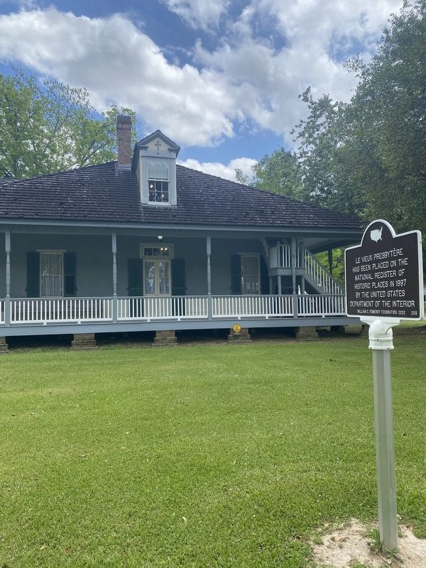
Le Vieux Presbytère has been placed on the National Register of Historic Places in 1997 by the United States Department of the Interior. — — Map (db m196525) HM
On North Parkerson Avenue (State Highway 13) south of West 12th Street, on the right when traveling south.
Founded 1886 & soon emerged as center of state's rice industry. Historic district listed on National Register of Historic Places. Significant for its impressive c.1890-c.1930 commercial area & its superb Victorian residences. — — Map (db m147011) HM
On River Road (State Highway 942) at St. Elmo Street (Parish Route 1435), on the right when traveling south on River Road.
Built in 1801 by Marius Pons Bringier as wedding gift for daughter Fanny, who married Christophe Colomb, a French refugee. Remodeled by Architect James Dakin 1837. Restored by Dr. & Mrs. E.G. Kohlsdorf 1941. — — Map (db m85285) HM
Near State Highway 942, 0.3 miles west of Stafford Levy Road, on the right when traveling west. Reported missing.
Greek Revival mansion built by Marius Pons Bringier as wedding gift for his son Michael Douradou, who named the house for General Andrew Jackson's home in Tennessee. The Jacksons visited here in the 1820s. — — Map (db m141734) HM
On State Highway 1, 0.2 miles south of State Highway 943, on the right when traveling south.
Scene of Civil War skirmish in fall of 1862. C.1850 Greek Revival plantation house owned 1854-1869 by Charles A. Kock, a prominent sugar planter. Listed on National Register of Historic Places in 1980. — — Map (db m96047) HM
On State Highway 308 at Madewood Road, on the right when traveling north on State Highway 308.
The first major building designed by noted architect Henry Howard. Construction of this Greek Revival mansion was begun in 1846, using materials from the land. Steamboats carried trade to Madewood on Bayou Lafourche. — — Map (db m87862) HM
On Whites Chapel Road, 0.3 miles south of State Highway 29, on the right when traveling west.
Gothic Revival church built in 1894 by Hugh and Lee Evans on land donated by Wilson A. O'Quin, Sr. It was named in honor of Rev. Frederick White who organized it in 1870. Listed on the National Register of Historic Places. — — Map (db m107478) HM
On L'Eglise Street (State Highway 107) south of Coco Street, on the right when traveling south.
Desfossé House Dr. Jules Charles Desfossé, second mayor of Mansura, acquired this c. 1790 house and rebuilt it c. 1850. This Louisiana French Colonial style dwelling was the 1st structure in Avoyelles Parish listed on the National . . . — — Map (db m97774) HM
On Spring Bayou Road (State Road 1190) east of Andrus Street, on the right when traveling east.
Large story and a half Acadian style residence built by Alfred Greenhouse and his wife Cecilia Bontempt. Greenhouse was a farmer, cattleman, landowner and hunter who often cared for cattle kept in the lowlands during the winter months. Indian . . . — — Map (db m117693) HM
On South Washington Street near East Odgen Street, on the right when traveling north.
Oldest commercial building site remaining in city. Built by Voinche, native of Paris, France. Later Victorian upper structure on only underground basement in city. Basement used to hide cotton from Union troops during Civil War. — — Map (db m98022) HM
On East Odgen Street near North Main Street (Louisiana Highway 107/115), on the right when traveling west.
Movie theater built in the Arts and Crafts style by the Mayer family. First known as the "Palace Theater". Home to "silent" movies and later "speaking" films until about 1975. High school commencements were held here prior to 1927. — — Map (db m98270) HM
On South Main Street (State Highway 115) south of West Barbin Street, on the right when traveling south.
Turn of the century Victorian home featuring Colonial influence. Wrap around porch with complete central hallway. Built by Dr. Aristide Barbin. Restored by Tucker Couvillon family in the 1950's and the Leon Satterthwaite family in the 1990's. — — Map (db m120982) HM
On North Washington Street north of Laurel Lane, on the right when traveling north.
Raised Greek Revival dwelling with Victorian influence built in 1872 by Alfred and Elizka Bordelon. Occupied by direct descendants. Listed on the National Register of Historic Places. — — Map (db m122655) HM
On North Monroe Street south of Tarleton Street, on the left when traveling south.
Full two story Arts and Crafts dwelling with Colonial Revival facade. Built by Michel Bettevy, prominent local banker. Later home to Leroy Havard family and the family of Dr. Alton DeNux, former Mayor and State Representative. — — Map (db m120955) HM
On South Washington Street north of Acton Street, on the right when traveling north.
Victorian dwelling Colonial influence. Built by Alfred Bordelon who practiced dentistry and law in Cottonport and Marksville. Built along northern edge of Spanish land grant of Francois Bordelon. — — Map (db m120984) HM
On South Main Street at West Barbin Street, on the right when traveling south on South Main Street.
Arts and Crafts style house built by Judge Lester Bordelon. Features a large central hallway flanked by gracious rooms and beveled glass entrance. — — Map (db m120973) HM
On West Bon Temps Street at Monroe Street on West Bon Temps Street.
Arts and Crafts style house
Circa 1920. Built as a spec
House by T. James and
Zepher Newton Brouillette.
Purchased as rental property
in May 1934 by Ceran R.
and Eliza Zimmer Guillot.
Similar to the house next
door, but smaller in size. — — Map (db m121174) HM
On West Bon Temps Street near North Monroe Street, on the right when traveling north.
Full two story dwelling built in classic Arts and Crafts style. Features tile roof, stained glass and original Arts and Crafts interior. Designed by Favrot and Livaudais of New Orleans for L. Jules Coco, prominent local merchant. — — Map (db m121066) HM
On South Main Street (State Highway 115) at Decuir Street, on the left when traveling south on South Main Street.
Modified Victorian and Arts and Crafts style home built by Albert Decuir, dairyman and farmer on Spanish land grant property of his ancestor, Francois Bordelon. Presently owned by Decuir's grandson. — — Map (db m120983) HM
On State Highway 1192 at North Main Street (State Highway 115), on the right when traveling north on State Highway 1192.
Arts and Crafts style home built by Forest Dupuis, merchant and undertaker. Located on the grounds were a mortuary, "filling station", dance hall, and garages to house a horse-drawn hearse and family vehicle. — — Map (db m97845) HM
On West Bon Temps Street at North Monroe Street, on the right when traveling north on West Bon Temps Street.
Arts and Crafts style house
Circa 1948. Rufus and Enola
Dupuy Guillory purchased the
property in April 1948 from
Tillman and Mabel Graham.
Perma Stone (faux stone) was
Placed on the exterior walls
and posts of the chain fence.
One of the . . . — — Map (db m121176) HM
On Waddil Street east of South Lee Street, on the right when traveling west.
Arts and Crafts style home built by Judge Phidias Gremillion. Is unique because it features a gabled roof. The wainscoted dining room is highlighted by a plate rail. — — Map (db m103700) HM
On South Main Street at Bon Temps Street, on the right when traveling north on South Main Street.
Two story brick mercantile store with Victorian embellishments features business quarters downstairs and living quarters upstairs. Mr. Printz, an Italian immigrant, began his career as a fruit peddler in Avoyelles Parish. — — Map (db m174211) HM
On North Monroe Street south of Tarleton Street, on the left when traveling south.
Classic Greek Revival home with heavy Colonial influence built by attorney, J.W."Buddy" Joffrion. Features a tile roof and spacious gardens. Designed by Favrot and Livaudais of New Orleans.Lower plaque: Joffrion House Has been placed on . . . — — Map (db m120928) HM
On North Main Street (State Highway 107/115) west of East Odgen Street, on the right when traveling west.
Arts and Crafts two story brick building built by Dr. E. M. Laborde and Cliffe E. Laborde for commercial use downstairs and dental and legal offices upstairs. Tidewater Marine, Inc., founded here in 1956. — — Map (db m103567) HM
On East Mark Street at South Washington Street, on the left when traveling east on East Mark Street.
Victorian mercantile store built by Lewis P. Roy, Sr. Restored in 1984-85 by attorneys Tucker Melancon and Rodney Rabalais and certified public accountants Aloysia C. Ducote and Van P. Major. — — Map (db m103699) HM
On West Mark Street at North Monroe Street, on the left when traveling south on West Mark Street.
Small brick edifice with
Victorian influence built
by William Peterman,
native of Pennsylvania
and a railroad attorney.
He married Belle Bordelorn
and later moved his practice
to Alexandria. — — Map (db m121177) HM
On South Monroe Street south of West Bon Temps Street, on the right when traveling south.
Built by L. P. Roy, Sr., prominent bank president, State Representative and local entrepreneur. Designed by Favrot and Livaudais of New Orleans in the Arts and Crafts style. Features a tile roof and much use of beveled glass throughout. "Sister" . . . — — Map (db m121196) HM
On South Washington Street near East Waddil Street, on the right when traveling north.
Founded by Rev. Fr. Jules Janeau in 1869 with worship in a Gothic frame Church. Replaced in 1926 by Msgr. Henry Van de Putten with this Romanesque structure designed by W. T. Nolan. — — Map (db m98023) HM
On Business U.S. 171 east of South Pine Street (Louisiana Highway 27), on the right when traveling east.
Center Panel
In 1912 when residents decided to divide Imperial Calcasieu Parish
into several smaller parishes, Beauregard Parish was born. The
people of Beauregard were optimistic about their future, and as . . . — — Map (db m229089) HM
Built by Don S. Coleman in 1960. Designed in the mid-century modern style showcasing an iconic wave roof of reinforced concrete and a free span vaulted ceiling. Originally “Holiday Bowl” with 32 lanes. — — Map (db m214288) HM
On Barksdale Boulevard (State Highway 72) at Monroe Street, on the right when traveling east on Barksdale Boulevard.
Cornerstone laid Nov. 26, 1926. Officially dedicated May 19, 1927. A fine example of the Spanish "Hacienda" style adapted for public buildings. The second floor still contains original jail cells. — — Map (db m109777) HM
On South Elm Street (Louisiana Route 157) 0.2 miles south of Fox Creek Street, on the right when traveling north.
Built 1883 after earlier house on site burned. Residence of Dr. Paul Lawrence. respected physician, who performed house calls for over 50 years despite the loss of a leg in the Civil War. Haughton was originally called Lawrenceville in his honor. — — Map (db m169679) HM
On Louisiana Route 157 north of Davis Road, on the left when traveling north.
Modified dog trot house is example of skills and creativity of early 20th century homes in Bossier Parish. It has one room on south side and three rooms on the north.
Built circa 1927 by Henry McDade for his wife, Artie Lee Patterson McDade and . . . — — Map (db m169361) HM
On Louisiana Route 612 west of Rogers Lane (Louisiana Route 157), on the left when traveling west.
This house was built in stages between 1832 and 1848, and by 1850 was owned by Doctor Abel Skannal. From this house the family controlled five plantations totaling over 8000 acres. Rumors about ghosts are sustained by the fact that Doc Skannal kept . . . — — Map (db m169284) HM
On Caddo Street (State Highway 3049) east of East Street, on the left when traveling east.
The original house was built in 1899 by Ruben T. Glassell, a planter, and his wife Vyvian. It faced west and had a center hall in the dogtrot style. The house was enlarged about ten years later with the addition of a new roof, interior columns, . . . — — Map (db m175072) HM
On Dixie Shreveport Road (Louisiana Route 3049) north of Louisiana Route 169, on the right when traveling north.
Killarney was built by James Stuart Douglas in 1920 and designed by Edward F. Neild, a prominent Shreveport architect in the firm C. E. Olschner Architect Assoc. This is one of the first homes designed by Mr. Neild. Mr. Douglas was a planter, civic . . . — — Map (db m175663) HM
On Louisiana Route 3049, 0.5 miles south of Sherman Drive, on the left when traveling south.
The Justice Chapel Baptist Church was organized in 1894 under the leadership of Rev. C.J. Justice and Brother Willie Davenport and his wife. Other leaders in this early church were Rev. Eddie Moore, Brother Eddy Green, Brother Frank Cook, Mathis . . . — — Map (db m174630) HM
On Louisiana Route 3049 south of Sartor Road, on the left when traveling south.
Organized June 6, 1919, with 12 charter members, and named in honor of Mrs. Linda Lay who had been instrumental in the development of the spiritual life in the town. Constructed in 1920, dedication of the building was held on August 14, 1921. The . . . — — Map (db m174628) HM
On U.S. 71, 0.1 miles north of Camellia Street, on the right when traveling north.
The house was built around 1878 and occupied by the William Adams family. James Patrick Fuller and his wife Gertie McKinney Fuller purchased the house in 1919. Their family included daughters Pattie Mae and Audrie, who was born in the house in 1920. . . . — — Map (db m244247) HM
On South Land Avenue, 0.1 miles south of Savage Street, on the left when traveling north.
Built 1910 at Trees, Louisiana. Moved to present site in 1983. Both Trees and Oil City are intimately associated with the oil boom of the early 1900s. Trees City was founded in 1909 by Trees Oil Company. Listed in National Register of Historic . . . — — Map (db m169898) HM
On Dixie Shreveport Road (Louisiana Route 3049) 1 mile north of Cash Point Plantation Road, on the right when traveling north.
Three historic plantations, Cash Point, Gold Point, and Buckhall Plantations, date back to 1839, when they were purchased by James Belton Pickett, Paulina de Graffenried, and James Blair Gilmer. The Buckhall portion on the north and east side was . . . — — Map (db m175957) HM
On Dixie Shreveport Road (Louisiana Route 3049) 1 mile north of Cash Point Plantation Road, on the right when traveling north.
In 1899, the large landholdings of James Pickett, one of the founders of Shreveport, began a series of ownership changes. In 1912, Samuel S. Pittman and his wife, Pattie, purchased land in Section 14, formerly held by James Pickett. The house, built . . . — — Map (db m175956) HM
Near Texas Avenue north of Lawrence Street, on the right when traveling north. Reported missing.
1057 Texas Avenue founded in 1866. Oldest Black Baptist Church in Shreveport. Built Present location in 1903. Romanesque Revival Style, by noted Architect N. S. Allen — — Map (db m180320) HM
On Austin Place south of Milan Street, on the right when traveling south.
752, The Hauser House, built 1867, remodelled c.1880. 754-56, The Cooke House, built c.1870. 758, The Dalzell House, built c.1870, was once rectory of St. Mark's Episcopal Church. Austin Place was originally known as Christian Street. — — Map (db m140833) HM
On Austin Place south of Milam Street, on the right when traveling south.
Built c.1883 at corner of Christian and Jewell Streets, opposite Oakland Cemetery. Moved from that site in 1976. Important example of Queen Anne cottage architecture. — — Map (db m140480) HM
On Austin Place south of Milam Street, on the left when traveling south.
Built 1897 by L.R. Logan, beer and ice manufacturer. Designed by architect Nathaniel Sykes Allen. One of the finest remaining Queen Anne Victorian houses in the city. — — Map (db m140477) HM
On Cotton Street, on the left when traveling north.
Designed by Edward Neild and Clarence Olschner with interior design work by Paul Heerwagen. Built in 1914. Housed B’nai Zion Synagogue -- founded 1859 -- from 1915 to 1956. Ten stained glass windows are by Lafarge. Listed in National Register of . . . — — Map (db m214289) HM
On Austin Place south of Milam Street, on the right when traveling south.
Designed by architect Luther T. McNabb. Built 1896 for grocer W.B. Olgilvie. Later residence of Samuel. G. Wiener, Sr. family. Noted architects Samuel G. Wiener, Jr. and William B. Wiener, Sr. were brought up in this house. — — Map (db m140478) HM
On Sprague Street at Christian Street, on the right when traveling west on Sprague Street.
Group of six Victorian cottages built circa 1890. Possibly remodellings of circa 1870 houses known to have stood on same site. Listed in National Register of Historic Places, 1983. — — Map (db m140460) HM
On Youree Drive (State Highway 1) at Ockley Drive on Youree Drive.
Built as Broadmoor School in 1929. Renamed in memory of Albert Coldwell Steere (1879-1930), influential businessman, philanthropist and real estate developer, and creator of Broadmoor area. Expanded 1938. Listed in National Register of Historic . . . — — Map (db m143801) HM
On Forest Avenue at Wheeless Avenue, on the left when traveling west on Forest Avenue.
Built in 1924 for Huey P. Long, Governor of Louisiana 1928-1932. Long's initials "H.P.L." are incorporated into the cast iron balcony above the front entrance. Listed in National Register of Historic Places, 1991. — — Map (db m143720) HM
On Ockley Drive at College Lane, on the right when traveling east on Ockley Drive.
Now called "Medjoy". Built 1929 as Dodd College President's Residence. Dodd College, named for its founder Dr. M.E. Dodd, operated 1926-1942. This house was Dr. Dodd's residence for many years, Listed in the National Register of Historic Places, . . . — — Map (db m143799) HM
On Fairfield Avenue near Kings Highway when traveling north.
Built 1921 by lumber and railroad executive Randle T. Moore. Moore was also chairman of the board of Commercial National Bank of Shreveport in the 1920's and a trustee and major benefactor of Centenary College. House designed by Shreveport . . . — — Map (db m143714) HM
On Line Avenue near Oneonta Street, on the right when traveling north.
Built in 1928. Designed in Bavarian Gothic style to blend with residential character of neighborhood. Listed in National Register of Historic Places, 1991. — — Map (db m143800) HM
On Fairfield Avenue at Kings Highway, on the right when traveling south on Fairfield Avenue.
Built 1923-25. Designed by Maritz and Young, architects, of St. Louis, Missouri. Considered one of the city's most important examples of Tudor Revival style architecture. — — Map (db m143719) HM
On Market Street (U.S. 71) at Crockett Street, on the left when traveling south on Market Street.
Parish Judge Washington Jenkins, on Nov. 4, 1840, sold his 2-story frame house to Caddo Parish for a courthouse. A jail replaced the kitchen. Courthouse was sold at foreclosure in 1855 at its own door. — — Map (db m138770) HM
On Texas Street (State Highway 79/80) east of McNeill Street, on the right when traveling east.
When the Caddo Parish Courthouse was built in 1926 it was the third one erected on this same plot of land and cost $1,2500,000. At the time of its dedication on April 21, 1928 it was debt free, paid for by taxpayers with a five year . . . — — Map (db m139869) HM
On Texas Street (U.S. 79/80) at Marshall Street, on the right when traveling east on Texas Street.
Third Courthouse to occupy site since 1860. First Courthouse on site served as Louisiana's Confederate Statehouse during Civil War. Present Courthouse designed by Neild & Somdal architectural firm. Built 1926-28. Served as model for numerous other . . . — — Map (db m109764) HM
On Edwards Street south of Travis Street, on the left when traveling north.
Built 1922, under the administration of Mayor John McWilliams Ford, to house Shreve Memorial Library. Designed by J. P. Annan in style of Roman Villa. Remained in use as central public library for over half a century. — — Map (db m139538) HM
On Edwards Street north of Texas Avenue (U.S. 79/80), on the left when traveling north.
Built 1922, under the administration of Mayor John McWilliams Ford to house Shreve Memorial Library. Designed by J. P. Annan in style of Roman Villa. Remained in use as Central Public Library for over half a century. — — Map (db m139864) HM
On Marshall Street at Fannin Street, on the left when traveling south on Marshall Street.
Established in 1856, Holy Trinity was moved to this site in 1858. Five of its priests lost their lives treating the victims of the Yellow Fever Epidemic of 1873. The present church, in Romanesque Revival style, was built in 1896. — — Map (db m168349) HM
On Texas Street (U.S. 79/80) at Marshall Street, on the right when traveling west on Texas Street.
Built 1910 to house Hutchinson Bros. Department Store. Has exceptional terra cotta detaining on front. Original plans called for a four story building, but was increased to six by contractor, who failed to meet deadline for completion. — — Map (db m109767) HM
On Cotton Street west of Mc Neil Street, on the right when traveling west.
Built 1924 to house Police department and City Court. Excellent example of early 20th century Neo-Classic/Federal architecture. Listed in National Register of Historic Places, 1982. — — Map (db m139543) HM
On Common Street (Louisiana Route 3036) at Cotton Street, on the right when traveling north on Common Street.
Designed by local architect Edward Neild who was an active member of the Shreveport Scottish Rite. It was built 1917. Listed in the National Register of Historic Places in 1986. — — Map (db m139902) HM
On Commerce Street at Texas Street, on the right when traveling south on Commerce Street.
100 block of Texas. Preserved block of early Shreveport commercial buildings, most dating from between 1860 and 1900. Excellent examples of 1880s-1890s cast iron found on many. Texas Street Bridge, which bisects block, was dedicated October, 1933 by . . . — — Map (db m109741) HM
On Louisiana Avenue south of Milam Street, on the left when traveling south.
Built 1925 for Saenger-Ehrlich Theatre Enterprises. Designed by architects Emile Weil and Charles G. Davis of New Orleans. Interior designed by Paul Heerwagen of Arkansas. Was flagship theatre of Saenger Amusement Co., a forerunner of Paramount. . . . — — Map (db m139906) HM
On Kirby Place west of Highland Avenue, on the right when traveling west.
Built circa 1859 as a farm house. Probably Highland's oldest surviving house. Originally located at the present site of Creswell School. — — Map (db m143537) HM
On Fairfield Avenue at Wilkinson Street, on the right when traveling south on Fairfield Avenue.
Built 1921 by prominent attorney John Bennett Files. Designed by noted Shreveport architect Edward Fairfax Neild, Mr. Files’ son-in-law. Outstanding example of pure Mediterranean Revival Style. — — Map (db m138878) HM
On Jordan Street west of Cicero Street, on the left when traveling west.
Founded 1845, present sanctuary built 1925, Designed by architectural firm of Jones, Roessle, Olschner and Wiener. Chapel adjoining buildings added later. Unusual curved pews are a noteworthy feature of the sanctuary. — — Map (db m142857) HM
On Kings Highway west of Line Avenue, on the right when traveling west.
Built 1925. Designed by prominent local architect Samuel Weiner, Jr. One of Shreveport's premier examples of Romanesque/Byzantine architectural styles. — — Map (db m143743) HM
On Jordon Street near Irving Place, on the right when traveling east.
Built 1898. One of the few remaining large Victorian houses in Highland. Named for owner Thomas C. Lewis, a Captain in the Confederate Army, and a pioneer druggist. — — Map (db m141031) HM
On Line Avenue near Wichita Street, on the right when traveling south.
Built 1904-05. Designed by noted local architect N.S. Allen. One of only 5 known Allen designed buildings remaining in Shreveport. Listed in The National Register of Historic Places, 1981. (1800 Line Avenue) — — Map (db m142708) HM
On Creswell Avenue at Wichita Street, on the right when traveling north on Creswell Avenue.
Built 1937. Designed by local architect Ted Flaxman. One of Shreveport's best examples of Modern Style. The building originally featured glass brick above the entrance. — — Map (db m142670) HM
On Line Avenue at Margaret Place, on the right when traveling west on Line Avenue.
Built 1938 for Agudath Achim Orthodox Jewish Congregation which occupied it from 1939 to 1980. Art Deco in style, the building was designed by Seymor Van Os. — — Map (db m142132) HM
On Margaret Place west of Line Avenue, on the right when traveling west.
Built 1925. Designed by local architect Clarence King. The Shreveport Little Theatre is the oldest continuously operating community theatre in the United States. — — Map (db m141658) HM
On Fairfield Avenue south of St. Mary Place, on the right when traveling north.
Designed as his own residence by John Y. Snyder in 1902. Snyder was a prominent area architect and a geologist of national importance. This house, which once had a wide front porch, is the last remaining residence on Fairfield north of Olive. — — Map (db m143008) HM
On Fairfield Avenue south of Sheridan Avenue, on the right when traveling south.
This grand Mediterranean-style mansion was built in the early 1900's as the home of James Alston Thigpen and his wife Mary Colvin Thigpen. Judge Thigpen was a respected lawyer and Caddo Parish judge, as well as a prominent landowner and oil . . . — — Map (db m143020) HM
On Fairfield Avenue at Wilkinson Street, on the right when traveling south on Fairfield Avenue.
Designed for banker William L. Trimble and wife Bessie by noted Shreveport architect Edward F. Neild. Completed 1929. Residence of the Trimble family until 1960. A pristine example of Georgian Revival Style. — — Map (db m138879) HM
On Greenwood Road (U.S. 79) east of Grosjean Street, on the right when traveling east.
Built 1937. Designed by Neild and Somdal architectural firm, of Shreveport. Frescoes over main entrance are by Conrad Albizio. Painted in 1938, they are believed to be the first outdoor frescoes in United States. Listed in National Register of . . . — — Map (db m143755) HM
On Greenwood Road (U.S. 79) east of Grosjean Street, on the right when traveling east.
The Louisiana State Exhibit Museum opened in 1939 under President Franklin D. Roosevelt's Public Works Program, "New Deal". It houses the largest topographical relief map in the state measuring 14 feet in circumference, and it also houses 22 . . . — — Map (db m143794) HM
On University Place, 0.2 miles west of Kigns Highway, on the right when traveling east.
Centerpieces of this center are Caspiana House, built at Caspiana, La., in 1856, and the Thrasher Cabin, a rural Caddo Parish "dogtrot" log cabin, built c. 1835. Caspiana house was listed in the National Register of Historic Places in 1981, the . . . — — Map (db m140326) HM
On Lake Charles Avenue near North Pine Street, on the right when traveling west.
Built in 1923, the depot is an outstanding example of Mission Revival architecture, and is one of the most architecturally significant railroad depots in the state. Listed on National Register of Historic Places. — — Map (db m140551) HM
On North Main Street at East Main Street, on the left when traveling west on North Main Street.
Built in 1860, this ante-bellum building was the point of departure for Confederate troops during the War Between the States. It is one of the finest examples of Southern expression of Greek Architectural style. — — Map (db m180237) HM
On Royal Street at North Boulevard, on the right when traveling south on Royal Street.
Beauregard Town founder Elias Toutant Beauregard was a retired military officer from New Orleans who became fascinated by neighborhood development. After buying a large parcel of land in Baton Rouge, Beauregard envisioned a community that would . . . — — Map (db m98527) HM
On Lafayette Street north of North Boulevard, on the right when traveling south.
Its architectural style has been both celebrated and criticized, but there's no disputing Louisiana's Old State Capitol is one of the nation's most distinct public buildings. Renowned architect James Dakin chose the building's Gothic Revival design. . . . — — Map (db m96602) HM
On North Boulevard east of Lafayette Street, on the right when traveling east.
James H. Dakin designed the 1850 Gothic Revival statehouse; the cast iron fence was added 1854-55. It served as the Capitol until occupied by Union forces during the Civil War. The interior burned in a fire in December 1862.In 1882, architect . . . — — Map (db m177928) HM
On Convention Street near North 4th Street, on the right when traveling west.
The congregation first organized in 1819, received their charter as St. James Church in 1844. The second church, of Gothic Revival style, was completed in 1895. Mrs. Zachary Taylor was an early member. — — Map (db m88274) HM
On North Sixth Street north of North Street, on the left when traveling south.
Founded in 1805, Spanish Town is Baton Rouge's oldest neighborhood having the oldest architectural history in the area. The surviving buildings represent popular styles from a period of Louisiana's history.
Spanish settlers from the Canary . . . — — Map (db m97968) HM
On North Third Street, 0.1 miles north of Capitol Access Road, on the left when traveling north.
The stately Old Governor's Mansion was commissioned in 1929 by Governor Huey P. Long in a style that deliberately mimicked the White House. It replaced a simple frame structure on roughly the same property and served as official residence until . . . — — Map (db m98053) HM
On North 3rd Street north of State Capitol Drive, on the right when traveling north.
Dedicated in 1932, the Louisiana State Capitol was commissioned by Governor Huey P. Long and was meant to symbolize the state's progress and modernity. At 34 stories, it is the highest state capitol in America and its Art Deco-inspired lines, . . . — — Map (db m96604) HM
The Acadian House was constructed on museum property in 1975. It was built from cypress lumber that was originally part of an old mule barn dismantled at Rapidan Plantation in St. James Parish.The frame was built in the mortise-and-tenon . . . — — Map (db m134472) HM
Near Essen Lane (State Road 3064) south of Interstate 10, on the right when traveling south.
The kitchen was built c. 1840 on Bagatelle Plantation near Union, Louisiana. It served as a kitchen originally but was later converted to a schoolhouse that was run by 3 of the Tureaud sisters. The building was changed back to a kitchen upon being . . . — — Map (db m112095) HM
240 entries matched your criteria. The first 100 are listed above. Next 100 ⊳