[English:]
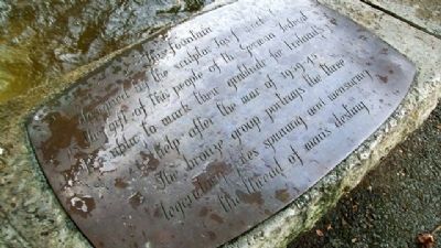
This fountain, designed by the sculptor Josef Wackerle, is the gift of the people of the German Federal Republic to mark their gratitude for Ireland's help after the war of 1939-45. The bronze group portrays the three . . . — — Map (db m25306) HM
On Merrion Row east of Saint Stephen's Green, on the left when traveling east.
Founded in 1693 by the French Huguenot non-conformist churches of Dublin and now belonging to the French Huguenot Fund. Restored in 1988 through a grant from the French Ministry of Foreign Affairs in association with FÁS. — — Map (db m307423) HM
Near Saint Stephen's Green at Grafton Street, on the left when traveling west.
[Gaeilge:]
Thaitin an Hibernian United Service Club stairiúil, os comhair na háite seo, go mór le hOifigigh Arm na Breataine mar chlub d’Fhir Uaisle.
Maidin Dé Máirt, an 25 Aibreán, ghabh Ceannaire agus tríocha fear ón 3ú . . . — — Map (db m307318) HM
Sunday Independent journalist,
was murdered on 26th June 1996.
Be Not Afraid
Greater justice was her ideal and it was her ultimate achievement
Her courage and sacrifice saved many from the scourge of drugs and other crime.
Her . . . — — Map (db m24078) HM
On Golden Lane at Chancery Lane, on the left when traveling east on Golden Lane.
Step into the history of Dublin and discover the rich heritage surrounding the Radisson Blu Royal Hotel, Dublin. Follow a self-guided trail through Le Pole Square, tracing Dublin’s story from its Viking roots to the lively tenement life of the 19th . . . — — Map (db m307808) HM
On The Square south of Haddington Road, on the left when traveling south.
Beggars Bush Barracks close to this location Volunteer Joseph Spooner 1901–1922 Dublin Brigade Oglaigh na nEireann of 67 McCaffrey Lane Mount Brown, Dublin was executed by The Free State Army on the 30th Nov. 1922 After being shot by . . . — — Map (db m304830) HM
On Anne Street South at Anne's Lane, on the left when traveling west on Anne Street South.
In the late 70’s DJ Dave Fanning performed weekly at this site, formerly McGonagles — which was the main venue for all major punk and new wave acts. — — Map (db m307775) HM
Near Ship Street Great south of Ship Street Little, on the left when traveling north.
Close to where you stand, Dublin’s name originated from ‘Dubhlinn’, meaning ‘Black Pool’ in Irish. This tidal pool was vital in shaping Dublin’s development. In 841, the Vikings established a harbour here, known as a longphort. The River Poddle, . . . — — Map (db m307786) HM
On Ship Street Great south of Ship Street Little, on the left when traveling north.
Entrance to S. Michael’s le Pole Church Yard Here anciently stood the church and the round tower. Adjacent lay the mill pond or “pool” which gave name to these buildings and to the old city gate in Bride Street. S. Bride’s Widows’ Alms . . . — — Map (db m307809) HM
Near Chancery Lane east of Bride Street, on the left when traveling south.
One of Dublin’s oldest parishes, a church is believed to have stood here even before the Vikings arrived. The churchyard once featured the city’s only round tower and gave the area its name, with “le Pole” referring to a pool from the nearby River . . . — — Map (db m307789) HM
On Custom House Quay (Leinster Route 801) 0.2 kilometers west of the Sean O'Casey Bridge, on the left when traveling west.
Commissioned and Donated to the People of Ireland
by Norma Smurfit
29th May 1997
'A procession fraught with most striking and most melancholy interest, wending its painful and mournful way along the whole line of the river, to . . . — — Map (db m269528) HM
On Custom House Quay (Leinster Route 801) 0.2 kilometers west of the Sean O'Casey Bridge, on the left when traveling west.
The Dublin Docklands comprises 520 hectares of land on the north and south banks of the River Liffey.
THE DIVING BELL
①950m←
Just a short walk from here stands the recently refurbished Diving Bell. Designed by . . . — — Map (db m269592) HM
On Custom House Quay (Leinster Route 801) 0.2 kilometers west of the Sean O'Casey Bridge, on the left when traveling west.
In memory of the victims of the Great Famine and for
their descendants who have done so much to build Canada.
En mémoire des victimes de la Grande Famine, et en hommage à
leurs descendants qui ont tant contribué à bâtir le . . . — — Map (db m269553) HM
On Custom House Quay (Leinster Route 801) at the Scherzer Rolling Lift Bridges, on the left when traveling west on Custom House Quay.
The Human Rights and Poverty Stone was inaugurated on 17 October 2008, the UN Day for the Eradication of Poverty. It was created by the Irish sculptor Stuart McGrath.
17 October Stones can be found in over 50 meeting places worldwide. They all . . . — — Map (db m269605) HM
On Custom House Quay (Leinster Route 801) at the Scherzer Rolling Lift Bridges, on the left when traveling west on Custom House Quay.
The Human Rights and Poverty Stone was inaugurated on 17 October 2008, the UN Day for the Eradication of Poverty. It was created by the Irish sculptor Stuart McGrath.
17 October Stones can be found in over 50 meeting places worldwide. They all . . . — — Map (db m269606) HM
On City Quay (Leinster Route 813) at Lombard Street East ( Route 814), on the right when traveling east on City Quay.
In honour of the Seamen lost
while serving on Irish merchant ships
1939 - 1945
City of Limerick 15-7-40
Brennan H. · Sullivan J.
Kerry Head 22-10-40
Begley T. · Byrne R. · Davidson W. · Drummond G. · McMahon M. · . . . — — Map (db m269632) HM WM
On Custom House Quay (Leinster Route 801) 0.2 kilometers west of the Sean O'Casey Bridge, on the left when traveling west.
In late May 1847, at the height of the Great
Famine, 1,490 tenants from the Mahon
Estate embarked on the gruelling 100 mile
(165 km) walk from Strokestown, County
Roscommon to Dublin Docks.
They were part of an assisted emigration . . . — — Map (db m269554) HM
On City Quay (Leinster Route 813) at Lombard Street East ( Route 814), on the right when traveling east on City Quay.
This park is named after Elizabeth O'Farrell
who was born here at 42 City Quay
Elizabeth played a full and active role
in the Easter Rising of 1916
Her life was dedicated to the cause of Irish Freedom
———————————————————
Tá . . . — — Map (db m269610) HM
On Sir John Rogerson’s Quay just east of Creighton Street, on the left when traveling east.
Sunk by U-boat
with twenty-four lives lost
27th December 1917
Chuir U-bhád go tóin poill í
Cailleadh ceithre dhuine is fiche
27 NoHaig 1917 — — Map (db m269684) HM WM
On Guild Street at North Wall Quay ( Route 801) when traveling south on Guild Street.
"But the general appearance of the river,
flowing between its quays and under its bridges,
has not changed. Yes, the river still gave the
impression it was flowing in the wrong direction."
The End.
———————————————
"Mais . . . — — Map (db m269692) HM
On Guild Street at North Wall Quay ( Route 801), on the left when traveling south on Guild Street.
Scherzer Bridges
In 1817 the Royal Canal was opened, connecting the River Shannon with
Dublin. The canal entered the River Liffey at North Wall Quay. A cast-iron single track swivel bridge was constructed to carry traffic on . . . — — Map (db m269703) HM
Near Inchicore Road west of South Circular Road, on the left when traveling west.
[Gaeilge:] Anseo, tar éis seachtain na Cásca, 1916, básaíodh na cinnirí seo a leanas [English:] Here, after Easter Week, 1916, the following leaders were executed P. H. Pearse • Thomas J. Clarke • Thomas MacDonagh — . . . — — Map (db m306841) HM
On Inchicore Road west of South Circular Road, on the left when traveling west.
[English:] Kilmainham Gaol & Courthouse Opened as the county gaol for Dublin in 1796, Kilmainham Gaol soon held a surge of Irish revolutionaries. From its first political prisoner, United Irishman Henry Joy McCracken, to its . . . — — Map (db m306835) HM
On Winetavern Street at High Street, on the left when traveling north on Winetavern Street.
1100’s Dublin Defends Itself by Building Outer Stone Walls [Français:] Dublin se défend en construisant des murs de pierre extérieurs [Deutsch:] Dublin verteidigt sich, indem Außenmauern aus Stein errichtet . . . — — Map (db m304824) HM
On Christchurch Place north of High Street, on the left when traveling south.
1500’s Silken Thomas Revolts Against the King of England [Français:] Silken Thomas se révolte contre le roi d’Angleterre [Deutsch:] Silken Thomas revoltiert gegen den König von England . . . — — Map (db m304828) HM
On Abbey Street Lower at O'Connell Street Upper, on the left when traveling east on Abbey Street Lower.
2nd Battalion Dublin Brigade
Irish Volunteers
who was shot and burned in these premises
Easter 1916
[Balance of marker in Cló Gaelach script is not transcribed] — — Map (db m240758) WM
On Parnell Street (Leinster Route 803) at Parnell Place, on the left when traveling east on Parnell Street.
"No man has a right to fix the boundary of the march of a nation; no man has a right to say to his country, thus far shalt thou go and no further."
Parnell Street
Formerly Great Britain Street, the street was renamed after Charles . . . — — Map (db m270490) HM
On Frederick Street North just south of Dorset Street Upper (National Route 1), on the left when traveling south.
This Building Housed the
Department of Labour
1919 - 1921
Countess Markievicz
First Minister for Labour
Dáil Éireann
Erected April 2016 — — Map (db m269811) HM
On Parnell Square North just east of Parnell Square West, on the left when traveling east.
Here on the 9th September 1914, the
Supreme Council of the Irish Republican Brotherhood
and other leaders decided upon a Rising
against British rule.
Anseo ar an 9 Meán Fómhair 1914, bhí
an Ard-Chomhairle Bhráithreachas . . . — — Map (db m269764) HM WM
On Frederick Street North at Frederick Lane North, on the left when traveling north on Frederick Street North.
I gcuimhe an dhglaigh, Diarmuid Ó Duidir, an
cúighiú cathán inneallcóirí, Driogáio Daile
Átha Cliath, Óglaigh na Éireann, a rugaoi Ros Mór,
Co. Chioora Arann, agus oa mhac léinn i Scoil Éanna,
Rath Fearnáin. Maraíodh e i . . . — — Map (db m269939) WM
On Parnell Square East just south of Parnell Square North, on the right when traveling south.
Sa Rotunda Rink a raibh a shuíomh sna gairdíní taobh leis sea
a bun aíodh oglaigh na hEireann 25 samhain 1913
The Irish Volunteers were founded in the Rotunda Rink, which was
located in the gardens next to [here], on . . . — — Map (db m269805) HM WM
On Parnell Square East at Parnell Square North, on the right when traveling south on Parnell Square East.
i ndorchacht an éadóchais rinneadh aisling dúinn.
lasamar solas an dóchais.
agus níor múchadh é.
i bhfásach an lagmhisnigh rinneadh aisling dúinn.
chuireamar crann na crógachta.
agus tháing bláth air.
i ngeimhreadh na . . . — — Map (db m269802) HM WM
On Grattan Bridge north of Essex Quay, on the right when traveling south.
Essex Bridge Erected 1755 Rebuilt by the Dublin Port and Docks Board 1875 Renamed Grattan Bridge By the Municipal Council 1875 Right Honble. Peter Paul M’Swiney, J.P., Lord Mayor Robert Warren, D.L., J.P., High Sheriff Bindon B. Stoney, . . . — — Map (db m304666) HM
On North Earl Street just east of O'Connell Street Upper, on the left when traveling east.
Unveiled by the Rt. Hon.
The Lord Mayor of Dublin
Alderman Senator Sean Haughey
on Bloomsday 1990.
Presented to the city by the
North Earl Street Business Association
and the D.C.C.B.A. — — Map (db m270502) HM
On O'Connell Street Upper at Prince's Street North, on the right when traveling north on O'Connell Street Upper.
And tyranny trampled them in Dublin's gutter until Jim Larkin came along and cried the call of freedom and the call of pride and slavery crept to its hands and knees and nineteen thirteen cheered from out the utter degradation of their . . . — — Map (db m241088) HM
On O'Connell Street Upper, on the left when traveling north.
[Top illustration caption reads]
The General Post Office and Nelson's Pillar in 1820
Nelson and the Spire
Long before the spectacular Spire of Dublin stood here this site belonged to a famous British admiral. Nelson's . . . — — Map (db m241105) HM
On O'Connell Street Upper at Prince's Street North, on the left when traveling north on O'Connell Street Upper.
[English:]
Nelson and the Spire
Long before the spectacular Spire of Dublin stood here this site belonged to a famous British admiral. Nelson’s Pillar was erected following Admiral Nelson’s victory over Napoleon at the . . . — — Map (db m307102) HM
On O'Connell Street Upper 0.1 kilometers south of Parnell Street, on the left when traveling south.
[Top photo caption reads]
Sackville Street, looking north, c.1750,
by Joseph Tudor
O'Connell Street
Long seen as the centre of Dublin, O'Connell Street is the city's favourite location for public commemorations and celebrations. . . . — — Map (db m241146) HM
On O'Connell Street Upper at Abbey Street Lower, on the right when traveling north on O'Connell Street Upper.
Erected by Public Subscription
to
Sir John Gray, Knt. MD. JP.
Proprietor of the
Freeman's Journal
M.P. Kilkenny City.
Chairman of the
Dublin Corporation Water Works
Committee 1860 to 1875,
during which period
preeminently . . . — — Map (db m240452) HM
On Jervis Street at Mary Street, on the left when traveling north on Jervis Street.
1700 The foundation stone of St. Mary's Church was laid in 1700. It was designed by SIR WILLIAM ROBINSON, the architect of the Royal Hospital Kilmainham and Marsh's Library.
1713 JONATHAN SWIFT, author of . . . — — Map (db m269914) HM
On O'Connell Street Upper at Parnell Street, on the right when traveling north on O'Connell Street Upper.
"No Man has a right to fix the
Boundary to the march of a nation
No man has a right
To say to his country
Thus far shalt thou
Go and no further
We have never
Attempted to fix
The ne-plus-ultra
To the progress of
Ireland’s . . . — — Map (db m269750) HM
On Mary Street just east of Jervis Street, on the left when traveling east.
On this site stood Ireland's very first
dedicated picture house, the
Volta Cinema
It was opened on Monday
20th December 1909
and managed by James Joyce.
The converted 430-seat venue was
renamed the LYCEUM in 1921. It . . . — — Map (db m269910) HM
On O'Connell Street Upper at Lower Abbey Street, on the right when traveling north on O'Connell Street Upper.
[Old Gaelic not transcribed]
Born 17th October 1803
Sentenced to death for
High Treason
on the
9th October 1846
Died
16th June 1864 — — Map (db m240453) HM
On Castle Street at Ship Street Great, on the right when traveling north on Castle Street.
[Gaeilge:] Sufraigéid A rinne smidiríní de na fuinneoga seo 13 Meitheamh 1912 [English:] Suffragette Smashed these windows 13th June 1912 — — Map (db m307813) HM
On Ship Street Great south of Ship Street Little, on the left when traveling north.
Once the Vikings established themselves in Dublin around 841, the city evolved into a major trading hub with links to mainland Britain and beyond. Over time the first Viking settlers developed their own identity by mingling with the native Irish, . . . — — Map (db m307783) HM
On Blessington Street just west of Dorset Street Upper (National Route 1), on the left when traveling east.
Ar an 27ú Meán Fomhair 1986
ainmníodh an foirgneamh seo in amós do
Chathal Mag Léid (1909-1982)
Óglaigh na hEireann
Chaith sé a shaol ag troid
ar son idéalacha an Fhorogra 1916
Beidh cuimhne go deo air.
———————————————— . . . — — Map (db m269813) HM
This basin was first commissioned by Dublin Corporation as a water
reservoir for the City in 1810. It underwent an extensive programme of
refurbishment between April 1993 and October 1994 and was formally
re-opened as a public amenity
by . . . — — Map (db m269816) HM
In 1810 the Basin at Blessington Street was constructed to act as a
reservoir to facilitate storage and distribution of water to the city from
the Royal Canal. The walls of the Basin are built from Calp limestone
and the bed is lined with blue . . . — — Map (db m270063) HM
On North Circular Road (Leinster Route 101) just west of Goldsmith Street, on the left when traveling west.
Do chum glóire Dé agus i mbuan-chuimhne na n-oifigeach agus na n-óglach nach maireann a throid ar son saoirse na h-Éireann is a bhí n-a (ina) mbaill tráth de chomplacht "C" den chéad chath de bhriogáid Átha Cliath d'arm na poblachta, . . . — — Map (db m270501) WM
On Eccles Street 0.1 kilometers west of Dorset Street Upper (National Route 1), on the left when traveling west.
Foundress of the Irish Branch of the
Institute of the Blessed Virgin Mary
(Loreto Sisters),
was born in this house
on the 6th January 1794
She died on the 19th May 1861 — — Map (db m269818) HM
Novelist and Philosopher
BORN HERE
Úrscéalaí agus Fealsamh
A RUGADH ANSEO
[Unveiled on 11th July 2019, to mark the 100th anniversary of her birth] — — Map (db m269817) HM
On Eccles Street just west of Dorset Street Upper (National Route 1), on the right when traveling west.
"At the housesteps of the 4th of the
equidifferent uneven numbers, number 7
Eccles St., he inserted his hand
mechanically into the back pocket of
his trousers to obtain his latchkey...."
Ulysses — — Map (db m269822) HM
On Blessington Street just west of Dorset Street Upper (National Route 1), on the right when traveling east.
Killed at Croke Park
on Bloody Sunday
LIVED HERE
A Maraíodh i bPáirc an
Chrócaigh ar Domhnach na Fola
A CHÓNAIGH ANSEO
[Unveiled 20 November 2023] — — Map (db m269815) HM WM
On Berkeley Road at Eccles Street, on the right when traveling north on Berkeley Road.
To the
Four Illustrious Masters
of the Franciscan Order
Michael O'Cleary, Fearfeasa O'Maolconry
Peregrine O'Cleary, Peregrine O' Duigenan
by whose untiring labours
at a time when hatred and persecution
raged against the Catholic . . . — — Map (db m270505) HM
On Little Britain Street at Green Street, on the left when traveling east on Little Britain Street.
(Inscription) [Gaeilge:]
A leac yo do togeaḋ é le arḃainc gur ar an ḃláiṫce ro ḃó ḃí con liġin lúaín na reaḃm. I rríoṫún Arḃeata nuaiḋ ris díoġas agur nar . . . — — Map (db m304652) HM
On Chesterfield Avenue 0.3 kilometers west of Parkgate Street/Conyngham Road (Route R109), on the left when traveling west.
These enclosed gardens were laid out in 1864 by the Earl of Carlisle. They cover an area of 9 hectares, including the lake and provide an opportunity to see a fine example of Victorian horticulture.
————————————————— . . . — — Map (db m241166) HM
On Chesterfield Avenue 0.4 kilometers west of Parkgate Street/Conyngham Road (Route R109), on the left when traveling west.
Asia and Europe saved by thee, proclaim
Invincible in war thy deathless name,
Now round thy brow the civic oak we twine
That every earthly glory may be thine.Conservata tuis Asia atoue Europa triumphis . . . — — Map (db m241169) HM WM
Near Newman House Saint Stephen's Green west of Leeson Street, on the left when traveling east.
[Gaeilge:] Go moch maidin Déardaoin, an 27 Aibreán 1916, ghabh Complacht de shaighdiúirí na Breataine ón Royal Irish Regiment, a raibh meaisínghunna Lewis d’arm acu, ionad ar dhíon Eaglais na hOllscoile, díreach os a chomhair seo. . . . — — Map (db m307212) HM
Near Saint Stephen's Green at Leeson Street, on the left when traveling north.
[Gaeilge:] Tugtar cur síos sa taispeántas seo ar an ról suntasach a bhí ag Páirc Fhaiche Stiabhna i rith Éirí Amach na Cásca 1916, nuair a bhí Éire ag iarraidh neamhspleáchas ó riail na Breataine. Tharla ceann de na cathanna ab . . . — — Map (db m307203) HM
On Superintendent’s Office, on the left when traveling south.
In remembrance of Anna Maria 1829–1922 and Thomas Haslam 1825–1917 This seat is erected in honour of their long years of public service chiefly devoted to the enfranchisement of women. — — Map (db m307010) HM
Near Saint Stephen's Green east of Harcourt Street, on the left when traveling east.
[Gaeilge:] Bhí cónaí ar Stiúrthóir na Páirce, James Kearney agus a theaghlach, sa lóiste i rith Éirí Amach na Cásca 1916. Bhris duine de na hÓglaigh fuinneog sa lóiste chun dul isteach ann agus thug sé ordú d’iníon an Stiúrthóra an . . . — — Map (db m307278) HM
Near Saint Stephen's Green at Leeson Street Lower, on the left when traveling north.
Páirc Fhaiche Stiabhna | Saint Stephen’s Green Park [Gaeilge:] Fáilte chuig Páirc Fhaiche Stiabhna Is féidir an pháirc phoiblí is ársa i mbaile Átha Cliath a rianú siar go dtí na meánaoiseanna. Ghac Tionól na Cathrach le . . . — — Map (db m307112) HM
Near Saint Stephen's Green at Harcourt Street, on the left when traveling east.
Páirc Fhaiche Stiabhna | Saint Stephen’s Green Park [Gaeilge:] Fáilte chuig Páirc Fhaiche Stiabhna Is féidir an pháirc phoiblí is ársa i mbaile Átha Cliath a rianú siar go dtí na meánaoiseanna. Ghac Tionól na Cathrach le . . . — — Map (db m307280) HM
Near Saint Stephen's Green north of Cuffe Street, on the right when traveling north.
[Gaeilge:] Luan Cásca, an 24 Aibreán, bhailigh an Chuntaois Markievicz eochracha do na tithe gloine chun óglaigh a gortaíodh a choinneáil ann agus ceathrar príosúnach freisin. Shonraigh an Stiúrthóir Kearney ina thuairisc an Sáirsint Hayden . . . — — Map (db m307281) HM
Near Saint Stephen's Green west of Leeson Street, on the left when traveling east.
[Gaeilge:] Is i gCath Fhaiche Stiabhna is mó a d’imir Óglaigh mhná ról in Éirí Amach na Cásca 1916, mar bhaill d’Arm Cathartha na hÉireann nó de Chumann na mBan den chuid is mó. Thug Arm Cathartha na hÉireann cead do mhná teacht isteach agus . . . — — Map (db m307205) HM
Near Saint Stephen's Green east of Harcourt Street, on the left when traveling east.
[Gaeilge:] As an áit seo, Luan Cásca an 24 Aibreán, chuaigh fórsa d’Óglaigh faoi cheannas an Chaptaein Richard McCormack amach le horduithe le seilbh a ghabháil ar Stáisiún Iarnróid Shráid Fhearchair agus é a choinneáil chun bac a . . . — — Map (db m307238) HM
Near Saint Stephen's Green west of Leeson Street, on the left when traveling east.
[Gaeilge:] Bunaíodh Ospidéal Catha anseo, ag Ardán na mBannaí Ceoil, mar chuid de gharastún Fhaiche Stiabhna i rith Éirí Amach na Cásca 1916. Bhí an Sáirsint Madeleine Ffrench-Mullen i gceannas ar an ospidéal catha agus bhí roinnt de . . . — — Map (db m307216) HM
Near Saint Stephen's Green at Leeson Street, on the left when traveling east.
[Gaeilge:] Gníomh míleata is ea cóir chosanta, i bhfoirm trinsí, chun áit a dhaingniú i gcoinne ionsaí. Rinneadh iad seo a thochailt ag na ceithre phríomhbhealach le teacht isteach agus os comhair Shráid Dhásain agus Hume i rith Éirí . . . — — Map (db m307202) HM